

GIS-based Environmental Sensitivity Index (ESI) mapping for oil ...
GIS-based Environmental Sensitivity Index (ESI) mapping for oil ...
GIS-based Environmental Sensitivity Index (ESI) mapping for oil ...
- No tags were found...

Create successful ePaper yourself
Turn your PDF publications into a flip-book with our unique Google optimized e-Paper software.
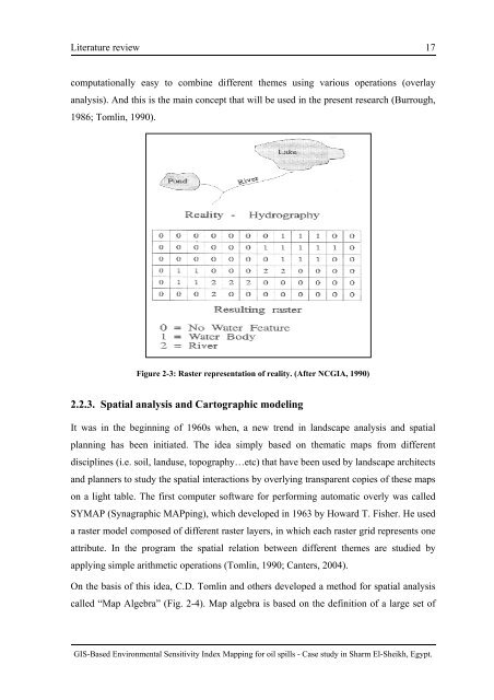
Literature review 17computationally easy to combine different themes using various operations (overlayanalysis). And this is the main concept that will be used in the present research (Burrough,1986; Tomlin, 1990).Figure 2-3: Raster representation of reality. (After NCGIA, 1990)2.2.3. Spatial analysis and Cartographic modelingIt was in the beginning of 1960s when, a new trend in landscape analysis and spatialplanning has been initiated. The idea simply <strong>based</strong> on thematic maps from differentdisciplines (i.e. s<strong>oil</strong>, landuse, topography…etc) that have been used by landscape architectsand planners to study the spatial interactions by overlying transparent copies of these mapson a light table. The first computer software <strong>for</strong> per<strong>for</strong>ming automatic overly was calledSYMAP (Synagraphic MAPping), which developed in 1963 by Howard T. Fisher. He useda raster model composed of different raster layers, in which each raster grid represents oneattribute. In the program the spatial relation between different themes are studied byapplying simple arithmetic operations (Tomlin, 1990; Canters, 2004).On the basis of this idea, C.D. Tomlin and others developed a method <strong>for</strong> spatial analysiscalled “Map Algebra” (Fig. 2-4). Map algebra is <strong>based</strong> on the definition of a large set of<strong>GIS</strong>-Based <strong>Environmental</strong> <strong>Sensitivity</strong> <strong>Index</strong> Mapping <strong>for</strong> <strong>oil</strong> spills - Case study in Sharm El-Sheikh, Egypt.


