GIS-based Environmental Sensitivity Index (ESI) mapping for oil ...
GIS-based Environmental Sensitivity Index (ESI) mapping for oil ...
GIS-based Environmental Sensitivity Index (ESI) mapping for oil ...
- No tags were found...
Create successful ePaper yourself
Turn your PDF publications into a flip-book with our unique Google optimized e-Paper software.
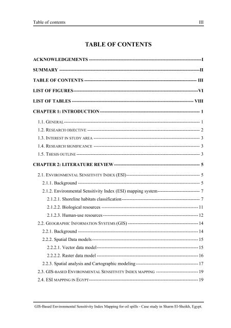
Table of contentsIIITABLE OF CONTENTSACKNOWLEDGEMENTS ------------------------------------------------------------------------ISUMMARY ------------------------------------------------------------------------------------------IITABLE OF CONTENTS ------------------------------------------------------------------------ IIILIST OF FIGURES--------------------------------------------------------------------------------VILIST OF TABLES ------------------------------------------------------------------------------ VIIICHAPTER 1: INTRODUCTION ---------------------------------------------------------------- 11.1. GENERAL--------------------------------------------------------------------------------------- 11.2. RESEARCH OBJECTIVE ------------------------------------------------------------------------ 21.3. INTEREST IN STUDY AREA -------------------------------------------------------------------- 31.4. RESEARCH SIGNIFICANCE -------------------------------------------------------------------- 31.5. TH<strong>ESI</strong>S OUTLINE ------------------------------------------------------------------------------- 3CHAPTER 2: LITERATURE REVIEW------------------------------------------------------- 52.1. ENVIRONMENTAL SENSITIVITY INDEX (<strong>ESI</strong>)----------------------------------------------- 52.1.1. Background ------------------------------------------------------------------------------ 52.1.2. <strong>Environmental</strong> <strong>Sensitivity</strong> <strong>Index</strong> (<strong>ESI</strong>) <strong>mapping</strong> system--------------------------- 72.1.2.1. Shoreline habitats classification-------------------------------------------------- 72.1.2.2. Biological resources --------------------------------------------------------------112.1.2.3. Human-use resources -------------------------------------------------------------122.2. GEOGRAPHIC INFORMATION SYSTEMS (<strong>GIS</strong>) ---------------------------------------------142.2.1. Background -----------------------------------------------------------------------------142.2.2. Spatial Data models--------------------------------------------------------------------152.2.2.1. Vector data model-----------------------------------------------------------------152.2.2.2. Raster data model -----------------------------------------------------------------162.2.3. Spatial analysis and Cartographic modeling----------------------------------------172.3. <strong>GIS</strong>-BASED ENVIRONMENTAL SENSITIVITY INDEX MAPPING ---------------------------192.4. <strong>ESI</strong> MAPPING IN EGYPT----------------------------------------------------------------------19<strong>GIS</strong>-Based <strong>Environmental</strong> <strong>Sensitivity</strong> <strong>Index</strong> Mapping <strong>for</strong> <strong>oil</strong> spills - Case study in Sharm El-Sheikh, Egypt.


