Historic Self-Guided Walk Beaumont - Meetup
Historic Self-Guided Walk Beaumont - Meetup
Historic Self-Guided Walk Beaumont - Meetup
- No tags were found...

You also want an ePaper? Increase the reach of your titles
YUMPU automatically turns print PDFs into web optimized ePapers that Google loves.
<strong>Historic</strong> <strong>Self</strong>-<strong>Guided</strong> <strong>Walk</strong><strong>Beaumont</strong>
BEAUMONTThe district was named <strong>Beaumont</strong> in 1846 by Samuel Davenport (1818- 1906) (knighted in 1884). He subdivided some of his land (Section 296)in 1849 in the style of an English village and laid it out around a ‘common’which still exists as public land. ‘<strong>Beaumont</strong>’ means ‘beautiful mount’ inFrench. The Davenport home was renamed <strong>Beaumont</strong> House in about1857 when Samuel and his wife first occupied it.The wider district was originally rural in character, with a scatter of namedproperties such as Gleeson’s Farm on which the family home of ‘Gleeville’(see Item 5) was established by Edward B Gleeson, from whom Davenportpurchased it. Gleeson’s Farm was later owned by J F Cleland. Other nearbyproperties were Belle Vue and Sunnyside, both established in about 1848.Davenport’s land was bounded by the following modern suburban roads:Glynburn Road, Dashwood Road, Devereux Road, and Cooper Place. Themodern suburb known as <strong>Beaumont</strong> covers more than double that area,including hilly lands to the east and south of the original holding.‘Glynburn’ is a composite name applied first in 1964 to provide a singlename for the whole length of the road whcih formerly had three names:<strong>Beaumont</strong> Road, Burnside Road, and Glynde Road.‘Dashwood Road’ was named after Captain G F Dashwood RN (1806 -1881) Commissioner of Police, who leased ‘Gleeville’ in 1852.Davenport was one of South Australia’s great pioneers - a scholar anda gentleman. He held many leading public offices and duties, as wellas heading various significant voluntary organisations. In 1846 he wasappointed a member of the Legislative Council when that body consistedof the Governor and four nominee members. He twice held office as aMinister of the Crown after responsible government was established in1851. He was a remarkably successful promoter of South Australian tradeespecially through the many international exhibitions held in major citiesduring the 19th century. He was also a vigorous experimenter with arange of agricultural activities including various livestock, grapes, olives,and tobacco; and mulberry trees for the raising of silk worms to supply anembryonic silk industry.The walk begins and ends at <strong>Beaumont</strong> House, at Stop 20, 631Glynburn Road, <strong>Beaumont</strong>. A public bus service terminates a fewhundred metres north on Glynburn Road and there is usually carparking outside <strong>Beaumont</strong> House.For more information on bus routes and timetables please referto www.adelaidemetro.com.au The distance covered by thiswalk is 2.5 km and takes approximately 1.5 hours to complete.There is a moderately steep uphill grade on the return from the<strong>Beaumont</strong> Common to <strong>Beaumont</strong> House.
1 <strong>Beaumont</strong> House - 631 Glynburn RoadThe dwelling on this Glynburn Road site began as a small five-roomedcottage around 1848.In 1851 Bishop Augustus Short (1802 - 1883),the first Anglican Bishop of Adelaide, movedinto the cottage, extended it and called it‘Claremont’. In 1855, when Bishop moved tothe new Bishop’s Court at North Adelaide, SirSamuel Davenport bought and occupied thehouse which he then renamed ‘<strong>Beaumont</strong>House’. They lived there until close to his deathin 1906. Other additions were made by Major Vincent between 1907 and1911. In 1967 the Brock family gave <strong>Beaumont</strong> House to the NationalTrust of South Australia.The design and construction of the building is unusual, especially theflat roof hidden by the decorative brick parapets. Inside the roof are thickinsulating tiles.<strong>Beaumont</strong> House is owned by the National Trust of South Australia and isopen to the public on the first Sunday of every month from 2 pm - 4.30 pm.<strong>Walk</strong> south along Glynburn Road towards the hills and on your right passand observe Item 2.2 A replica post and rail fenceLike those erected by Bishop Short and an olive grove planted bySamuel Davenport in the 1860s. This grove is but a tiny remnant of thethousands of trees of earlier times.Ahead of you are the <strong>Beaumont</strong> Hills. Turn right into Dashwood Road.3 Site of former winery and olive press - near 43 Dashwood RoadOn the western side of Short Crescent (named after Bishop Short),Samuel Davenport established a winery and also produced olive oilwith the help of his nephew G F Cleland, then living at ‘Gleeville’.Continue west down Dashwood Road.4 Occasional remnant olive trees - in the general areaWhen <strong>Beaumont</strong> was first sub-divided the original blocks were each ofabout two acres. Davenport planted olives in 1852 around the verges ofmost blocks. A few occasional trees have survived and may still be notedby the casual observer. However, the vines which filled the allotments arenow gone.Take care crossing at the round-about at Dashwood Road/Devereux Road.
5 Site of first house - 1 Dashwood RoadIn 1838 Edward Gleeson erected the first house,‘Gleeville’. This timber cottage was pulled down in1903 because of damage by white ants. Gleesonalso built the surviving stone stables on the wall ofwhich is a National Trust plaque which reads: 1839(sic). The barn of Gleeville-Under-the-Hills. Restoredafter the fire 1942.6 New plaque (2002)Generations of the Cleland family have occupied this property (‘Gleeville’)since 1852. At first they leased it and later purchased it from SamuelDavenport whose wife Margaret was the sister of John Fullerton Cleland.The Cleland’s added to the original wooden cottage in stone and it isthese rooms which are still standing. Over generations the family hasbeen prominent in several professions in more than one state of Australia.7 House - ‘The Croft’, Sunnyside RoadThe house at the western end of Dashwood Road on Sunnyside Road wasbuilt by Malcom Tweedie around 1903. His apricot orchard stretched toPortrush Road. It was established around 1909 but by the early 1920s theorchard was abandoned and the land was subdivided by two separateplans.Enter the walkway, on the corner of Sunnyside and Dashwood Roads andgo to Inverness Avenue. Turn right (east) then left through a narrow entryto the Davenport Olives.8 The Davenport Olives (and memorial plaque)This remnant grove planted in 1864 was given to the City of Burnside bySir John Cleland’s family to commemorate Davenport’s contribution tothe olive oil industry. The grove was established from cuttings brought toSouth Australia in 1845. The plaque provides further information.<strong>Walk</strong> to the northern end of this grove into John Cleland Drive, then turnleft into Devereux Road.9 Devereux RoadWas named after Jane Devereux, mother of Samuel Davenport.Turn right into West Terrace and walk east to the open parkland known as<strong>Beaumont</strong> Common (‘the Common’).
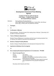
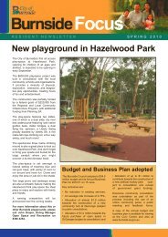
111214<strong>Beaumont</strong> C1510131650m100m
1819ommon17a202117b2223NW ES
10 House - 15 Sturt PlaceFormerly owned by the Cleland family, this houseis built on a sloping block facing the Common.Notable landscaping features include the matureolives which border the property. These trees areprobably part of the Cleland family’s early olivegroves and are important for this association withthe family.11 Plaque on <strong>Beaumont</strong> CommonMounted on a rock at the western end of the Common, the plaquecommemorates the centenary of Samuel Davenport’s 1849 vesting of thisland ‘in perpetuity for the enjoyment of the inhabitants of the village of<strong>Beaumont</strong>.’ It was passed to the City of Burnside in 1973.<strong>Beaumont</strong> Common vegetationThe numerous survivors of the original pre-European vegetationmake this public space an important conservation area. Over the years<strong>Beaumont</strong> Common has been regarded as a park and has thereforebeen planted with ornamental trees, both native and exotic. Most of thesupplementary planting has taken place around the edges, perhaps withthe object of improving the outlook for residents in the neighbouringarea. Some exotics have also been planted along the creek line.Among the survivors are remnants of the original ‘Black Forest’ whichcovered part of the Adelaide Plains from south-east of central Adelaide,extending roughly from the current suburb of Black Forest to GreenhillRoad and up to, and including, <strong>Beaumont</strong> Common. The name ‘BlackForest’ derived from the dark trunks of the numerous rough-barked gumtrees known as the grey box, Eucalyptus microcarpa. Despite the name,the Black Forest was a grassy woodland of mixed species. The largestspecimen on <strong>Beaumont</strong> Common is probably over 500 years old.The City of Burnside works to protect all indigenous remnant vegetationas part of its biodiversity initiatives. In places it has encouraged the understoreyof local native grasses and planted local shrubs and wild flowers.Mulch is used to suppress weeds and to stop further compaction of thesoil. Mulch under trees indicates that the specimens are almost certainlyremnants from before 1849. In two areas there are fenced enclosuresaround damaged old trees. The soil in the enclosures has a fungal diseasewhose spread can be controlled by exclusion of walkers.The following descriptive list of species is presented in suggested walkingsequence from west to east citing the identification numbers shown onthe map. By following the map it should be possible to find the correctspecimens described in the text.
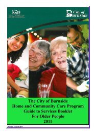
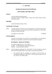
12 Grey Box (Eucalyptus microcarpa)Is wide-spread across the Common. This particularspecimen is unusual and is the largest and oldesthere, perhaps over 500 years old. Its swollen baseis a lignotuber. A lignotuber produces new stemswhich become new trunks to replace the centraltrunk as is gradually ages.13 Blue gum (Eucalyptus leucoxylon)This tall pair is situated either side of the road on the south edge of theCommon. There are others on the Common.14 Moreton Bay Fig (Ficus macrophylla)Although this shady tree is not native to the area, it is of historicalimportance because it is said to have been planted in 1857 tocommemorate the visit of the then Duke of Edinburgh.15 Wilga (Geijera parviflora)A solitary graceful tree from the range lands of South Australia.16 Tower House - 14 The CommonThis is one of the enduring landmarks beside<strong>Beaumont</strong> Common. The first rooms were builtbefore 1850 by William Vansittart. The tower wasadded in about 1880 by a later owner (probablySt. Barbe Miller).17 Vegetation typical of the originalThis is one of the two small patches (17a and 17b on the map) on theCommon where the City of Burnside has recreated a sample of theoriginal ‘Black Forest’ plant community once widespread across theAdelaide Plains. Under the Blue Gums and Golden Wattles have beenplanted at least 15 different grasses, herbs, lilies and small shrubs. All ofthese would have grown here originally as native ground cover. In theirseason they provide a diversity of colours and important shelter andfood for small animals - birds, lizards and insects. It now also providesthe observer with insight into how the woodlands have changed. Moreinformation is available on the Council’s signboard (Item 19) at thenorthern edge of the Common near the only River Red Gum (Item 18).
18 River Red Gum (Eucalyptus camaldulensis)This is the only specimen on the Common and stands at the downhillend of a creek line. It is of moderate size and age, and may have grownsince European settlement.19 City of Burnside Information boardThis explains the conservation and restoration project, and lists species ofspecial interest. (Some of these names are included at the end of thesenotes - see appendix).20 The creek lineThis usually dry drainage hollow carries a mix of introduced eucalyptsalong with native Swamp Wattle (Acacia retinodes), a variety of sedges andHop Goodenia (Goodenia ovata). The creek line carries a lot of water fromstreet run-off at times of rain.21 Aleppo pines (Pinus halepensis)A pair on the eastern side of the creek line. These are fast-growing weedytrees that are damaging the original Grey Box trees near them.22 Native or Slender Pine (Callitris gracilis)Tall and slender, this is the only specimen on the Common and certainlypre-dates settlement. It carries no cones and the young ones aroundit have been planted from seed collected from other remnant treesin Burnside.23 Plaque near the eastern car park (on the south side)This acknowledges an award made in 2000 by the Civic Trust of SouthAustralia to the City of Burnside for its work in conservation of remnantGrey Box woodland.24 Site of the former Lodge - 30 The Common (south west corner)By 1852, Samuel Davenport had built a house in which he lived until1857, after which it became ‘The Lodge’ when he transferred to <strong>Beaumont</strong>House. A driveway connected the two houses.To conclude, walk east up East Terrace to Glynburn Road and turn right(south) to <strong>Beaumont</strong> House.
An electronic copy of this historic self-guided walk and other historic walkswithin the City of Burnside can be found on www.burnside.sa.gov.auEvery effort has been made to ensure the content of this brochure is accurate.If you have any feedback about the content, please contact us via the BurnsideCouncil website at www.burnside.sa.gov.auAPPENDIXNames of some of the original species in the rich understorey of<strong>Beaumont</strong> Common/Black Forest.Kangaroo Grass Themeda triandraWallaby Grass Danthonia spp.Short-leaved Bluebush Maireana brevifoliaKangaroo Thorn Acacia paradoxaGold Dust Wattle Acacia acinaceaClasping Goodenia Goodenia amplexansChristmas Bush Bursaria spinosaTwiggy Daisy-bush Olearia ramulosaCreeping Saltbush Atriplex semibaccataRuby Saltbush Enchylaena tomentosaHopbush Dodonaea viscosaSpreading Flax-lily Dianella revoluta
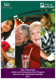
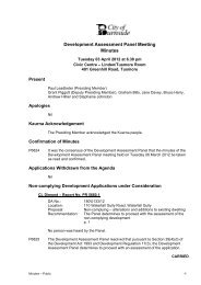
SUNNYSIDE RDBYRONCOOPERPLPENARTHVANSITTARTGLYNBURNFERNLEIGHADNUNDACLEARVIEWWILLIAMSKINCARDINEDEVEREUX RD8GLENROY AV9JOHNWEST TCECLELAND DRSTURT PL10THE COMMON<strong>Beaumont</strong> Commonsee separate mapTHE COMMONBENNETT AVSTARTROADBURTONGREY AVBUCHAN24EAST TCESHORT157 6DASHWOODTHIRKELL AVEBELLEVUE DRTENNYSON DR4AVMILTON AVECAITHNESS AVE3ROAD2MONTROSE PLTRAVERS DR250m500mNW EOriginal text by the Burnside Branch of theNational Trust and the Burnside <strong>Historic</strong>al SocietyS1st Revision August 19812nd Revision May 19913rd Revision August 20074th Revision February 2011Published by City of Burnside401 Greenhill Road, Tusmore 5065
401 Greenhill RoadTusmore SA 5065Telephone (08) 8366 4200Facsimile (08) 8366 4299www.burnside.sa.gov.au