Geophysical and hydrogeologic investigation of groundwater in the ...
Geophysical and hydrogeologic investigation of groundwater in the ...
Geophysical and hydrogeologic investigation of groundwater in the ...
- No tags were found...

Create successful ePaper yourself
Turn your PDF publications into a flip-book with our unique Google optimized e-Paper software.
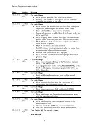
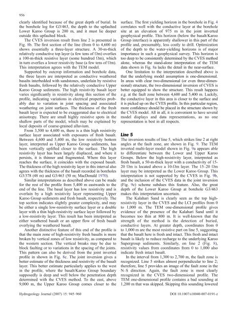
956clearly identified because <strong>of</strong> <strong>the</strong> great depth <strong>of</strong> burial. In<strong>the</strong> borehole log for G3/463, <strong>the</strong> depth to <strong>the</strong> upfaultedLower Karoo Group is 200 m, <strong>and</strong> it must lie deeperoutside this upfaulted block.The CVES <strong>in</strong>version result from l<strong>in</strong>e 2 is presented <strong>in</strong>Fig. 8b. The first section <strong>of</strong> <strong>the</strong> l<strong>in</strong>e (from 0 to 4,600 m)shows essentially a three-layer structure. A 30-m-thickrelatively conductive top layer (a few tens <strong>of</strong> Ωm) overliesa 100-m-thick resistive layer (some hundred Ωm), which<strong>in</strong> turn overlies a lower resistivity base (a few tens <strong>of</strong> Ωm).This <strong>in</strong>terpretation agrees with <strong>the</strong> TEM model.Supported by outcrop <strong>in</strong>formation <strong>and</strong> borehole data,<strong>the</strong> three layers are <strong>in</strong>terpreted as conductive wea<strong>the</strong>redbasalts <strong>in</strong>terbedded with s<strong>and</strong>stones, underla<strong>in</strong> by resistivefresh basalts, followed by <strong>the</strong> relatively conductive UpperKaroo Group sediments. The high resistivity basalt layervaries significantly <strong>in</strong> resistivity along this section <strong>of</strong> <strong>the</strong>pr<strong>of</strong>ile, <strong>in</strong>dicat<strong>in</strong>g variations <strong>in</strong> electrical properties probablydue to variation <strong>in</strong> jo<strong>in</strong>t spac<strong>in</strong>g <strong>and</strong> associatedwea<strong>the</strong>r<strong>in</strong>g on jo<strong>in</strong>t surfaces. The thickness <strong>of</strong> <strong>the</strong> freshbasalt layer is expected to be exaggerated due to electricalanisotropy. There are small highly resistive spots <strong>in</strong> <strong>the</strong>shallow parts <strong>of</strong> <strong>the</strong> model, which may be expla<strong>in</strong>ed bylocal deposits <strong>of</strong> coarse-gra<strong>in</strong>ed alluvium.From 3,500 to 4,600 m, <strong>the</strong>re is a th<strong>in</strong> high resistivitysurface layer associated with exposures <strong>of</strong> fresh basalt.Between 4,600 <strong>and</strong> 5,400 m, <strong>the</strong> low resistivity bottomlayer, <strong>in</strong>terpreted as Upper Karoo Group sediments, hasbeen vertically uplifted closer to <strong>the</strong> surface. The highresistivity layer has been largely displaced, <strong>and</strong> where itpersists, it is th<strong>in</strong>ner <strong>and</strong> fragmented. Where this layerreaches <strong>the</strong> surface, it co<strong>in</strong>cides with <strong>the</strong> exposed basalt.The thickness <strong>of</strong> <strong>the</strong> high resistivity layer <strong>in</strong> this <strong>in</strong>terval alsoagrees with <strong>the</strong> thickness <strong>of</strong> <strong>the</strong> basalt recorded <strong>in</strong> boreholesG3/378 (48 m) <strong>and</strong> G3/463 (50 m; MacDonald 1970).Similar <strong>in</strong>terpretations as described above can be madefor <strong>the</strong> rest <strong>of</strong> <strong>the</strong> pr<strong>of</strong>ile from 5,400 m eastwards to <strong>the</strong>end <strong>of</strong> <strong>the</strong> l<strong>in</strong>e. The basal layer has low resistivity <strong>and</strong> isoverla<strong>in</strong> by a high resistivity layer represent<strong>in</strong>g UpperKaroo Group sediments <strong>and</strong> fresh basalt, respectively. Thetop section <strong>in</strong>dicates slightly greater complexity, <strong>and</strong> maybe ei<strong>the</strong>r a s<strong>in</strong>gle low-resistivity surface layer or a doublelayer with a th<strong>in</strong> high-resistivity surface layer followed bya low-resistivity layer. This result has been <strong>in</strong>terpreted asei<strong>the</strong>r wea<strong>the</strong>red basalt or an upper flow <strong>of</strong> fresh basaltoverly<strong>in</strong>g <strong>the</strong> wea<strong>the</strong>red basalt.Ano<strong>the</strong>r dist<strong>in</strong>ctive feature <strong>of</strong> this end <strong>of</strong> <strong>the</strong> pr<strong>of</strong>ile isthat <strong>the</strong> ma<strong>in</strong> zone <strong>of</strong> high-resistivity fresh basalts is morebroken by vertical zones <strong>of</strong> low resistivity, as compared to<strong>the</strong> western section. The vertical breaks may be due toblock fault<strong>in</strong>g or to variations <strong>in</strong> <strong>the</strong> spac<strong>in</strong>g <strong>of</strong> <strong>the</strong> jo<strong>in</strong>ts.This pattern can also be derived from <strong>the</strong> jo<strong>in</strong>t <strong>in</strong>vertedpr<strong>of</strong>ile <strong>in</strong> shown <strong>in</strong> Fig. 8c. The jo<strong>in</strong>t <strong>in</strong>version gives abetter estimate <strong>of</strong> <strong>the</strong> thickness <strong>and</strong> resistivity <strong>of</strong> <strong>the</strong> basaltlayer. This better estimate particularly applies to <strong>the</strong> west<strong>in</strong> <strong>the</strong> pr<strong>of</strong>ile, where <strong>the</strong> basalt/Karoo Group boundarysupposedly is deep <strong>and</strong> well below <strong>the</strong> penetration depthdeterm<strong>in</strong>ed with <strong>the</strong> CVES method. To <strong>the</strong> east, above9,000 m, <strong>the</strong> Upper Karoo Group comes closer to <strong>the</strong>Hydrogeology Journal (2007) 15: 945–960surface. The first yield<strong>in</strong>g horizon <strong>in</strong> <strong>the</strong> borehole <strong>in</strong> Fig. 4correlates well with <strong>the</strong> conductive layer at <strong>the</strong> boreholesite at an elevation <strong>of</strong> 975 m <strong>in</strong> <strong>the</strong> jo<strong>in</strong>t <strong>in</strong>vertedgeophysical pr<strong>of</strong>ile. This horizon (below <strong>the</strong> basalt/KarooGroup <strong>in</strong>terface) is apparently shallower <strong>in</strong> this part <strong>of</strong> <strong>the</strong>pr<strong>of</strong>ile <strong>and</strong>, presumably, less costly to drill. Optimization<strong>of</strong> <strong>the</strong> depth to <strong>the</strong> water-yield<strong>in</strong>g horizons is <strong>of</strong> majorimportance <strong>in</strong> such a geophysical survey. This horizon istoo deep to be consistently determ<strong>in</strong>ed by <strong>the</strong> CVES methodalone, whereas <strong>the</strong> st<strong>and</strong>-alone <strong>in</strong>terpretation <strong>of</strong> <strong>the</strong> TEMdata shown <strong>in</strong> Fig. 8a lacks <strong>the</strong> detail <strong>in</strong> <strong>the</strong> near-surface.One limitation to <strong>the</strong> <strong>in</strong>terpretation described above isthat <strong>the</strong> underly<strong>in</strong>g model assumption is one-dimensional.In areas with clear two-dimensional (or even three-dimensional)structure, <strong>the</strong> two-dimensional <strong>in</strong>version <strong>of</strong> CVES isbetter equipped to show <strong>the</strong> structure. This result happense.g. at <strong>the</strong> fault zone between 4,600 <strong>and</strong> 5,400 m. Luckily,<strong>the</strong> conductive layer <strong>in</strong> this area is closer to <strong>the</strong> surface <strong>and</strong>it is picked up on <strong>the</strong> CVES pr<strong>of</strong>ile. In this particular region,more confidence should be placed <strong>in</strong> <strong>the</strong> structure shown by<strong>the</strong> CVES model. All <strong>in</strong> all, it is convenient to have severalmodel displays <strong>and</strong> data representations, as no onerepresentation is best <strong>in</strong> all respects.L<strong>in</strong>e 5The <strong>in</strong>version results <strong>of</strong> l<strong>in</strong>e 5, which strikes l<strong>in</strong>e 2 at rightangles at <strong>the</strong> fault zone, are shown <strong>in</strong> Fig. 9. The TEM<strong>in</strong>verted multi-layer model shown <strong>in</strong> Fig. 9a appears ableto differentiate between <strong>the</strong> Lower <strong>and</strong> Upper KarooGroups. Below <strong>the</strong> high-resistivity layer, <strong>in</strong>terpreted asfresh basalt, a 50-m-thick layer with a conductivity <strong>of</strong> 15-20 Ωm is located above a 10-Ωm layer. The 15–20 Ωmlayer may be <strong>in</strong>terpreted as <strong>the</strong> Lower Karoo Group. This<strong>in</strong>terpretation is not supported by <strong>the</strong> CVES <strong>in</strong> Fig. 9b,<strong>and</strong> <strong>the</strong> <strong>in</strong>clusion <strong>of</strong> <strong>the</strong> CVES data <strong>in</strong> <strong>the</strong> jo<strong>in</strong>t <strong>in</strong>version(Fig. 9c) scheme subdues this feature. Also, <strong>the</strong> greatdepth <strong>of</strong> <strong>the</strong> Lower Karoo Group at borehole G3/463makes this <strong>in</strong>terpretation uncerta<strong>in</strong>.The Kalahari S<strong>and</strong> is clearly seen as <strong>the</strong> top highresistivitylayer <strong>in</strong> <strong>the</strong> CVES <strong>and</strong> <strong>the</strong> LCI pr<strong>of</strong>iles from 0to 1,000 m. The TEM one-dimensional pr<strong>of</strong>ile givesevidence <strong>of</strong> <strong>the</strong> presence <strong>of</strong> <strong>the</strong> Kalahari S<strong>and</strong> until itbecomes too th<strong>in</strong> at 800 m. It is well-known that <strong>the</strong>strength <strong>of</strong> <strong>the</strong> method is <strong>the</strong> detection <strong>of</strong> buried,conductive layers. At greater depth, coord<strong>in</strong>ates from 0to 1,000 m are <strong>the</strong> most resistive part on l<strong>in</strong>e 5, suggest<strong>in</strong>gthat <strong>the</strong> basalt here is fresh <strong>and</strong> <strong>in</strong>tact. This fresh <strong>and</strong> <strong>in</strong>tactbasalt is likely to reduce recharge to <strong>the</strong> underly<strong>in</strong>g KarooSupergroup sediments. Similarly, on l<strong>in</strong>e 2 (Fig. 8),resistivity values from coord<strong>in</strong>ates from 0 to 1,000 also<strong>in</strong>dicate fresh <strong>in</strong>tact basalt.In <strong>the</strong> <strong>in</strong>terval from 1,300 to 2,700 m, <strong>the</strong> fault zone isrecognized. L<strong>in</strong>e 5 strikes almost perpendicular to l<strong>in</strong>e 2;<strong>the</strong>refore, l<strong>in</strong>e 5 provides an image <strong>of</strong> <strong>the</strong> fault zone <strong>in</strong> <strong>the</strong>N–S direction. Aga<strong>in</strong>, <strong>the</strong> fault zone is most clearlyrecognized <strong>in</strong> <strong>the</strong> CVES two-dimensional pr<strong>of</strong>ile. TheTEM one-dimensional pr<strong>of</strong>ile conta<strong>in</strong>s a bad sound<strong>in</strong>g at1,200 m that was skipped. Skipp<strong>in</strong>g this sound<strong>in</strong>g loweredDOI 10.1007/s10040-007-0191-z