Burma Development 1953 Vol1 Part11.pdf - Nathan Associates
Burma Development 1953 Vol1 Part11.pdf - Nathan Associates
Burma Development 1953 Vol1 Part11.pdf - Nathan Associates
- No tags were found...

Create successful ePaper yourself
Turn your PDF publications into a flip-book with our unique Google optimized e-Paper software.
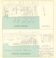
376 ECONOMIC AND ENGINEERING DEVELOPMENT OF BURMAroad surface in many districts also deteriorated extensivelyfor want of maintenance due to the fact that some of theroads were inaccessible."The main districts affected were Pegu, Toungoo,Magwe, Mandalay, Meiktila, Insein, Prome, Thaton,Amherst, Tavoy, Mergui and Akyab."As far as it is possible to estimate, more than 150bridges costing about Rs. 11,00,000 were destroyed. Thecost of repairs to some of these amounted to Rs.3,81,840as the rest of the destroyed bridges had not as yet beenreconstructed as the bridges had not been accessible, hav¬ing been in insurgent areas."Then follows a hst of some 47 roads which wereaffected in insurrection, and some of them were veryseriously damaged.The destruction of bridges is very great, for therepair or replacement of 150 structures is in itself amajor operation, one that the department would findweU nigh impossible to cope with in any one year.Also, the cost of replacement is still another heavyburden to be placed on the shoulders of the wholepopulation.Civil strife, too, is not without human tragedy tothose who must perform public work. During 1950 51,one coohe foreman was taken to a newly restoredbridge near Gwegyo and murdered as "a threatagainst future offenders." And, in an attack on Merguiin 1951 the deputy commissioner was killed in action.During the year, also, a department transport driverwas killed by an insurgent land mine and threelaborers were killed in an attack on a departmenttruck.6. GAPS IN SYSTEMAs indicated in preceding paragraphs of this sectionof the Report, there are some important gaps in thecontinuity of the highways of <strong>Burma</strong>. The gaps dis¬cussed in detaU thus far have been almost entirelythose resulting from lack of structures along the mainroutes of the system. In many cases, bridges aresimply war casualties which have not yet been re¬placed, or casualties of the later civil strife. In othercases, the lack is simply that the current stage ofdevelopment of the system is such that the need forthe particular river crossing, or other improvement,has not fully manifested itself.In a few cases, such as those of the replacement ofthe demolished spans of the Ava Bridge, and of therelocation and reconstruction of the Sittang crossing,the need for the facility is so great that its building islong overdue. For these major projects, the generalfacts and brief background relating to each are listedbelow. Necessarily, the order in which these are under¬taken is a problem with many facets, not the least ofwhich is the availability of funds for the work. All ofthe projects are important, and in the fuU develop¬ment of highway transport in <strong>Burma</strong> all these (andmany others, as yet unknown in either nature orscope) will be undertaken. The order in which theyare set down is a reflection of their urgency and oftheir importance to the orderly and adequate up¬building of the highways of the Union.(a) At Ava, 12 miles south of Mandalay, Route VIIcrosses the Irrawaddy River. The original structurehere, a combined railway-highway bridge, was a warcasualty, two 350-ft. spans having been demohshed bythe British during the evacuation in AprU 1942. Thebridge is a very important link in the whole networkbut has not yet been put back in service. Two crudeand wholly inadequate ferries are now operating be¬tween Amarapura and Sagaing, and a traffic delay ofup to 25 minutes can occur under the present opera¬tion. The ferry having the larger vessels, carryingloads up to eight tons, is a toll facility and the fee forpassenger cars is KIO. The closing of this gap is themost vital step to be taken in the highway rehabihta¬tion program, and should be given very high priority.(b) At Myitnge, 12 miles south of Mandalay onRoute I, a 1 |-mile diversion is now in effect to replacethe bridge over the Myitnge River. The diversion con¬sists of Bailey spans, the total length being 580 ft. Theoriginal crossing was a combined raUway-highwaystructure, and was destroyed during the war. The re¬placement bridge carries only the raUway, and tendersare now (July <strong>1953</strong>) being invited for the substructureand superstructure of the new highway bridge whichis to have a total length of 755 ft.(c) At Pegu, Route I crosses the Pegu River at thewest edge of the city. Using parts of BaUey trusses,and cables, a suspension span was constructed here bythe British IV Corps during the war. However, thebridge is in such a bad state of repair at present that itis in dangerous condition and needs replacement. Ithas a single-lane roadway, traffic being controlled frompohce booths at the ends of the bridge. The towershave no cross bracing nor struts, and are very badlyout of vertical. It is understood that the Departmentexpects to replace this structure with a two-span trussbridge located slightly upstream from the present site.(d) At Takaw, Route IV crosses the Salween River,the service being afforded by a toll ferry the fee forwhich is K5 for a private car and KIO for a truck. Ithas been proposed that a bridge be constructed at thiscrossing, and on September 15, 1952 the consultanttransmitted to the Secretary of National Planning andReligious Affairs his preliminary views on the design,type of structure, etc. Later, conferences were heldwith the Principal Works Officer, Shan States, and onDecember 10,1952, recommendations for the crossingand estimates of cost were submitted to him. As a