Burma Development 1953 Vol1 Part11.pdf - Nathan Associates
Burma Development 1953 Vol1 Part11.pdf - Nathan Associates
Burma Development 1953 Vol1 Part11.pdf - Nathan Associates
- No tags were found...

You also want an ePaper? Increase the reach of your titles
YUMPU automatically turns print PDFs into web optimized ePapers that Google loves.
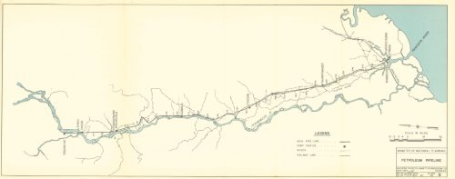
LEGENDMAIN PIPE LINEPUMP STATION 0ROADSRAILWAY LINE ,,,,,,SCALE IN MILES8 4 0 16MINISTRY OF NATIONAL PLANNINGPETROLEUM PIPELINEKNAPPEN TIPPETTS ABBETT ENGINEERING CONEW YORK.^-7^ RANGOONCK BY! n.R.n DATEPLATEMAY 53. NO. 8
The summary of these costs and charges then is asfollows:Interest and AmortizationOperation, Maintenence, and Over¬headToll Charges at Twante Canal375,000tons/year(K)7,20,60033,98,03082,500INLAND WATERWAYS 347500,000tonsjyear(K)9,41,33044,43,8301,10,000The transport distance is 417 miles and the numberof ton-mUes would be 156,375,000 and 208,500,000respectively for the two cases under investigation. Thecorresponding costs would be:Cost per tonCost per ton-mile375,000 tonsjyear 500,000 tonsjyear(K) (K)11-203 10-99000269 0-0264e. Transport by PipelineThe oil pipeline from the fields at Yenangyaungand Chauk to Rangoon and Syriam was destroyedduring the war. An exact survey of the damage wasnot made; however, it is considered that at least 50 %of the Une can be assumed to be destroyed as well asaU plant and equipment, the majority of the buildings,and other facilities. Therefore, for the purpose of thisstudy, two estimates of the costs of the pipehne wereprepared. One estimate is based on the assumptionthat it would be necessary to rehabihtate 50 % of thehne, 95 % of the houses and buildings and all of theplant, equipment and bridges. The second estimateevaluates the costs of the new construction of theentire hne and of all appurtenant faciUties.tion of amortization charges and maintenance coststhe foUowing useful-Ufe periods and maintenancerates were used:Useful- Annual maintenlife ance, per centyears of first costsHouses, buildings and quarters 50 1Pipeline and fittings 25 1Plant and equipment 15 3Since greater maintenance costs are to be expected onthe rehabilitated hne than on an entirely new one, theannual maintenance costs of the latter were assumedat about 90 % of the maintenance costs of the rehabili¬tated Une.In estimating the annual operating costs and thecosts of management and administration it was con¬sidered that the personnel costs would remain thesame, whether the daUy pumping rate would be 7,500bbl. or 10,000 bbl., but that the pumping costs wouldvary directly with the quantity of material pumped.On this basis the summary of annual costs and chargesfor the rehabilitated pipeline and for a newly con¬structed one would be as follows:Interest and amortiza¬tionOperation, maintenanceand overhead375,000 tonsjyear 500,000 tonsjyearRehab,line(K)29,12,80028,85,280Newline(K)42,70,91028,19,850Rehab,line(K)29,12,80031,94,400Newline(K)42,70,91031,28,970f. Cost of Transport by Pipeline(1) First CostsThe summary of the two estimates is as follows:Foreign Local TotalCosts Costs Costs(K) (K) (K)Rehabilitation of exist¬ing pipeline (cost permile Kl,28,390) 2,37,04,150 1,63,53,670 4,00,57,820Construction of a newpipeline (cost per mileComparison of Costs of Riverine Transport ofPetroleum and of Transport by Pipeline375,000 tonsjyear(K)Cost per ton500,000 tonsjyear(K)(2) Annual Costs and Charges and Costs per TonIn estimating the annual costs and charges theinterest rate as well as the rate of compound interestof sinking amortization fund was 5% on foreignexpenditures and 4% on local costs; in the determina¬h. ConclusionsThe preceding analyses were made of the two mosteconomical types of petroleum transport, by bargefleets and by pipehne, and were determined on asequitable a basis as possible. The comparison of
348 ECONOMIC AND ENGINEERING DEVELOPMENT OF BURMAtransport costs per ton demonstrates that the riverinetransportation of petroleum from the fields at Chaukis more economical than by pipeline, even though anew flotUla is compared with a rehabilitated pipeline.An additional advantage of riverine transport is itsflexibility. The fleet provided for the transport ofpetroleum from the upper Irrawaddy can be used onany of the major inland waterways of <strong>Burma</strong>. For thepurpose of this study the sizes of riverine fleet weredetermined for transport of either 375,000 tons or500,000 tons annually from Chauk to Rangoon. Thefunds required for the acquisition of this fleet aretentatively included in the program of expenditures ofIWTB for capital investments in the fiscal years <strong>1953</strong>-54 to 1961-62. However, the final size of the petrol¬eum fleet would be determined by the extent of thedevelopment and the location of the new oil-fields.E. PERSONNEL TRAINING PROGRAMWith the progressive rebuilding of the general-cargoand passenger fleet to prewar strength the InlandWater Transport Board would need additional quali¬fied personnel of approximately the foUowing classi¬fications:1. SHOP FOREMENIn 1952 IWTB and ECA TCA submUted firm re¬quests for funds for overseas training for a foundryforeman, a galvanizing-plant foreman, and a dieselshopforeman. With the termination of the ECA/TCAprogram these requests were cancelled and the neces¬sary funds would have to be provided by IWTB.2. INSTRUCTORS IN DIESEL ENGINEERINGTo train additional diesel operators which would berequired with the progressive increase of the number ofdiesel-powered craft.3. MARINE ENGINEERING DESIGNERSStructural (hull) and mechanical, who wUl thentrain the design force of IWTB in modern practices ofship design.This program of training of technical personnel inEurope and in the United States already has beeninitiated by IWTB and its continuation and develop¬ment are recommended.In the handling of bulk cargoes such as coal andpetroleum the method of transport would be by fleetsof barges propelled by push towboats. Since that formof propulsion is entirely new to <strong>Burma</strong>, it would benecessary to train phots completely in that form oftransport and the recommended training program in¬cludes the costs of such instruction. Pilots' schoolswill be required and towing units used for practicaltraining.F. CONCLUSIONSThe foregoing considerations with respect to theoperations of the riverine fleet lead to the followingsummary of conclusions and recommendations:(1) The Inland Water Transport Board is a trans¬port agency and should not be engaged in river con¬servancy operations.(2) All marine shipbuilding and repair facUitiesshould be merged under one department, the Depart¬ment of Yards and Docks, and be administeredthrough the Ministry of Transport and Communica¬tions.(3) The Government should acquire the ArakanFlotiUa Company, Ltd., and incorporate it in the In¬land Water Transport Board.(4) The IWTB's three-year and ten-year programsfor rehabihtation of its fleet, together with a similarplan for rehabilitation of the river conservancy fleet isconcurred in and should be prosecuted vigorously.(5) To relieve the friction developed by misunder¬standings with labor and to improve technical skiUs,educational instruction and training should be system¬atically provided.(6) Facihties for landing, cargo handling andstorage, at the main river ports on the Irrawaddy andChindwin Rivers, should be improved insofar asjustified by the increase in commerce requirements.(7) When the Kalewa coal and the Myingyan in¬dustrial projects are developed, most bulk productsshould be transported by water.G. ESTIMATED REQUIRED EXPENDITURESThe accompanying Table XIII-1 shows the esti¬mated program of expenditures for capital invest¬ments and for personnel training. This program ex¬tends over ten succeeding years. The main costs arefor the flotUla required in rehabihtating the prewargeneral-cargo and passenger fleet, and for the fleetsrequired in the transport of the products of the pro¬posed Kalewa coal development, the Myingyan indus¬trial development, and for transporting crude oil fromthe producing fields in the Irrawaddy basin to the pro¬posed refineries at Syriam. The investment costs ofrehabilitating the dockyards and improving them forthe fabrication and maintenance of the new vesselsand craft are included in the table basically becausethey have been an incremental cost in the determina¬tion of transport unit rates. These expenditures wouldnot be a part of the transport agency's operating costs,but would be diverted to the Department of Yardsand Docks which was recommended in Chapter XII.In a similar manner the costs shown in the table forwaterway conservation fleet and operations would bediverted to the operating costs of the MercantileMarine Department.
^ 8 8 81 I §• ^"8. 8.r."5 o" v, In >o in »n «o in W)■^O O Q O o1^ 8 S 8 Scn^ rn O^ en^ en^«■irT in »^ irT in" in'"S 8o. o^ o^ o^ o^ O^ o^0\ '"' .^ ^ ^ ,-, "^ ■^o^ 8 8 8o""5>o q. vo vo in vo^ vo vo00 ^^ —*-H 1-H■^ '^ "^ '—'§ ^- ^" 1 8. 1;i; 8 8 8 8 8. 8 8 8 8 8!0"VO vo" vo" vo"vo"•«: t--_^ ^« oo oo r*- oo oo»—» °^»—1 1-H 1—1 t-H 1—1--'K"IIIQh-i!/3pi!i-J1—^ Q >;>< Z .vi"^ w ^I-lm■< X ""^h-li; 8K8.8 8. 8 888 8888 .... 8 8 8 8 8 8 8 8 8 8 8.O*— " c^ ON >n o O O N vo Ocn^ ■^ (N (S 1--" vo ''i^ oC■^ o ^ (N n^ t^ O mo" cTts f-i rn t^o r^" «rr»o OfS fS" O en T-. -*" en vo" en" t-T ON"" vo""S »n \o^ -H Tt as
A. COASTAL STEAMSHIP SERVICES INPREWAR AND POSTWAR PERIODS1. PREWAR PERIODBefore the war the following steamer services wereoperating between the seaports of <strong>Burma</strong>:(a) Two steamship companies provided regular sailingstwice a week between Rangoon and Chittagong, calling atthe ports of Sandoway (Andrew Bay), Kyaukpyu andAkyab.(b) Two coastal steamers were operated on a weeklyservice between Rangoon, Mouhnein, Tavoy, Mergui andVictoria Point.(c) The Straits Shipping Company operated a fort¬nightly service between Moulmein and Penang, calling atTavoy, Mergui and Victoria Point.2. POSTWAR PERIODDue to the loss of numerous vessels during the warand due to other causes it was impossible to re-estab¬hsh the regular steamer services of the prewar period:(cr) On the Rangoon to Akyab run the commercialoperators were reluctant to call at Kyaukpyu and Sando¬way and it was possible to obtain only the irregular ser¬vices of the British India Steam Navigation Company andothers on the Rangoon Akyab Chittagong Calcutta run.{b) One of the coastal steamers was reinstated on afortnightly service, Rangoon Moulmein Mergui, in 1946.This vessel was lost in 1947 and has not been replaced.(c) The Straits Shipping Company extended its service toRangoon and its vessel S.S. Matang, of about 1,470 grosstons, is the only vessel supplying scheduled service to theTenasserim ports of Moulmein, Tavoy, Mergui and VictoriaPoint. This vessel makes a round trip between Rangoonand Penang approximately once in every three weeks.Thus, in the postwar period there were no scheduledsteamer services between Rangoon and Arakan portsand only one three-weekly service between Rangoonand the Tenasserim ports. The additional demandwas partly covered by non-scheduled private operatorsoften sailing with vessels of low safety factors.B. INVESTIGATION OF NEEDS FOR STEAMERSERVICESCHAPTER XIVOCEAN SHIPPINGthere were no prospects that these essential serviceswould be supplied by private shipping companies,domestic or foreign, their provision by Governmentwas indicated. At the same time, a favorable possibilityto enter the international shipping business presenteditself to Government as a consequence of the national¬ization of rice export trade. The government agencyhandling all rice export, the State Agricultural Market¬ing Board, sells rice f.o.b. One of the principal im¬porters is India, which in turn supplies the coal im¬ported in <strong>Burma</strong> by the Coal and Coke Agency forand on behalf of Government. Should the import coaland part of the export rice be transported in govern¬ment-owned vessels, rice for India could be sold c.i.f.,thus allowing a more favorable position in the worldmarket. Simultaneously, transport of coal from Indiain Burmese vessels would produce savings in transportcosts and in foreign exchange.It could be reasonably estimated that even with thedevelopment of the indigenous Kalewa coal depositsand with the progressive dieselization of power, anannual import of not less than 150,000 to 180,000 tonsof coal would be required. If a foreign commerce wereestablished on the basis of importing that amount ofcoal and exporting a similar amount of rice the vesselswould be guaranteed full cargoes for each trip, an idealeconomic condition for transport.In the realization of these benefits the Nautical Ad¬viser reported to the Ministry of Transport and Com¬munications in August and September 1951, recom¬mending the organization by the Government ofcoastal services with three vessels and of rice-coaltrade with India with four vessels. While it wasindicated that the <strong>Burma</strong>-India steamship servicewould be a very profitable venture, it was pointed outthat the operation of coastal service may show atemporary loss. However, the Nautical Adviser con¬cluded that "what is of paramount importance is thatservices of this most essential nature will have beenestablished under the direct control of the Govern¬ment of the country and not be subject to the whimsand fancies of outside influences."1. PRELIMINARY STUDIES2. RECOMMENDATIONSThe needs for re-establishing regular coastal steamer The reports of the Nautical Adviser are concurred in,services between <strong>Burma</strong>'s seaports have been made and it is recommended that the operations of proposedstill more pressing due to the restriction of all forms of services be placed under a separate agency or aland commerce since the beginning of insurgency. As maritime board.350
C. UNION OF BURMA SHIPPING BOARD1. AUTHORIZATIONBy executive order No. 75, dated June 6, 1952, to becalled Union of <strong>Burma</strong> Shipping Board Order, 1952,the President established the Shipping Board respon¬sible to the Minister of Transport and Communica¬tions and consisting of a full-time chairman and othermembers not exceeding ten, to be appointed by thePresident. As of June <strong>1953</strong> the Board consisted of fourmembers, the chairman, the general manager, and onerepresentative each of the Ministry of Transport andCommunications and of the Ministry of Finance andRevenue. The Nautical Adviser and Principal Officer,Mercantile Marine Department, acts as adviser to theBoard.2. FUNCTIONSAccording to the Executive Order "the functions ofthe Board shall, subject to the control of the Presidentof the Union, be generally to regulate, maintain andoperate coastal steamer service and steamer servicebetween India and the Union of <strong>Burma</strong>, and to con¬trol the rates at which a vessel in such service, registeredin the Union of <strong>Burma</strong>, may be hired and the rates atwhich persons or goods may be carried in such vessel,and the Board shaU, subject to the control of the Presi¬dent of the Union, also undertake other activitiesnecessary or expedient for the proper carrying out ofits functions under this order."3. ORGANIZATIONAs of June <strong>1953</strong> the organization of the Board,under the direction of the general manager, consistedof the headquarters staff at Rangoon of about 50persons and of about the same number of ship andfield personnel. It is intended to nominate the portofficers of the outports as agents of the Board, supply¬ing them with a separate staff" for the purpose. AtAkyab the port officer, due to a heavy work load, wasunable to take on additional duties and the Boardnominated the senior pUot as its agent. At the portswhich do not have port officers (as Kyaukpyu andSandoway) the Board has its own full-time agents.4. INITIATION OF COASTAL STEAMSHIP SERVICESIn July 1952 the Board acquired in Norway a second¬hand vessel of about 1,420 gross tons. The vessel, re¬named S.S. Pyidawtha, was rebuilt so as to accom¬modate 12 first-class passengers, 14 second-class pas¬sengers, some 350 deck passengers and cargo. Thevessel arrived in Rangoon at the end of January <strong>1953</strong>and started the regular service between Rangoon andAkyab on February 10, <strong>1953</strong>. It calls at the port ofKyaukpyu and at Sandoway except during monsoonseason. A landing place to replace Sandoway duringOCEAN SHIPPING 351monsoon season will be provided in the near future.Bassein has not been made a port of call since it canbe served adequately from Rangoon by the InlandWater Transport Board. A trip from Rangoon toAkyab and return requires about seven days, and thedepartures from Rangoon to Akyab take place aboutevery ten days. The key positions on S.S. Pyidawtha,such as Master, First Officer, and Chief Engineer aremanned by foreign personnel under three-year con¬tracts. A similar arrangement probably will be neces¬sary on future vessels of the Board until adequateBurmese personnel can be trained. Eventually allvessels will be manned by nationals.5. PLANNED ADDITIONAL STEAMSHIP SERVICESAs of June <strong>1953</strong> the Board had on order two newcoastal steamers of approximately the same capacityas S.S. Pyidawtha. Their delivery is scheduled forAugust 1954 and November 1954 respectively. It isplanned to put one of the vessels in the Rangoon toAkyab service with the possible extension to Chitta¬gong, East Pakistan. The other vessel wiU start theservice between Rangoon and Tenasserim ports withpossible extension to Penang should the circumstanceswarrant it.For the <strong>Burma</strong>-India coal and rice trade the Boardhas on order two new vessels of about 8,000 grosstons. Their respective dehveries are scheduled forAprU 1954 and August 1954.6. BUDGETThe total budget of the Union of <strong>Burma</strong> ShippingBoard, as approved by the Board (but not yet ap¬proved by the Government), is Kl,80,00,000 for fiscalyear 1952-53, and K 1,50,00,000 for fiscal year<strong>1953</strong>-54.D. CONCLUSIONIt was indicated in the interim report that in orderto improve the over-all economics of the shippingoperations of the Board, investigations were neededof more efficient methods of loading of export rice andunloading of import coal for the purpose of reducingthe handling costs and the turn-around time of vessels.The results of these investigations together with re¬commendations for the construction and operation ofseparate rice-handling wharves and a coal-handlingwharf in the Port of Rangoon are presented in ChapterXII. In the event that economic disadvantages preventthe use of the indigenous Kalewa coal in the Rangoontrade area, it is recommended that the Board at theproper time acquire such additional vessels for the<strong>Burma</strong>-India rice and coal trade as will permit thetransportation of the entire tonnage of imported coalin government-owned vessels.
CHAPTER XVPORTS AND WATERWAYS CONSERVANCYA. INTRODUCTIONIt has been shown in the preceding Chapters XIIand XIII that the seaports and commercially navi¬gated inland waterways of <strong>Burma</strong> are of extremeimportance to the economic needs of the country.Foreign trade is necessary to the national and eco¬nomic life. Since seagoing transport is the principalmedium for shipping and receiving foreign goods, it isevident that the seaports and their entrance channelsmust be adequate to provide safe and dependablenavigating conditions. The inland water-borne tradeover the rivers and canals has long been and wUl con¬tinue to be a principal method of transporting freightbetween the principal cities, trade centers and sea¬ports. The inland waterways, too, must be conserved,maintained and improved to insure efficient andeconomical handling of the nation's goods.Because of the difference between the types andrequirements of vessels engaged in coastwise andforeign commerce and the craft engaged in the riverinetrade, conservancy activities may be divided into twogroups, one dealing with seaports and the other withinland waterways.B. CONSERVANCY FOR SEAPORTSExcept for the Port of Rangoon, the responsibUitiesof maintaining properly the project dimensions of theentrance channels and harbors of the seaports of<strong>Burma</strong> rest with the Mercantile Marine Department,under the Ministry of Transport and Communications.At the ports of Akyab, Bassein, and Moulmein theresponsibihty rests with a Port OflScer who is assignedto each station by the Department. At these ports thePort Officer, assisted by the local District Commis¬sioner who is responsible for the funds, maintainsproject depths and widths; provides aids to navigation;markers and buoys; provides harbor anchorage buoysand general-cargo handhng facilities and furnishesvessel pilotage services. At the ports of Tavoy andMergui the commerce does not yet warrant the assign¬ment of a separate Port Officer, and conservancy isaccomplished through the local District Commissionerunder the general supervision and direction of theNautical Adviser and Principal Officer, MercantileMarine Department.The Mercantile Marine Department maintains twodredges, buoy vessels, pUot vessels, hydrographic sur¬vey equipment and other necessary craft. Except forthe dredges, all other equipment should be replacedat the earliest practicable date, and the estimatedreplacement costs of the necessary plant have beenincluded in Chapter XII under the sections for thePorts of Akyab, Bassein, Moulmein, Tavoy andMergui. The government boatyard at Dawbon isoperated by the Mercantile Marine Department. Italso operates a boatyard at Mandalay for the UpperIrrawaddy and Chindwin Rivers conservancy fleets,and is to construct as soon as practicable boatyardsat the Ports of Akyab, Moulmein and Mergui. Thesubject of marine repair facilities has been discussedin the pertinent sections of Chapter XII, and therecommendation has been made therein to transferthese facihties to a Department of Yards and Docks.The costing of these facihties was included in ChapterXII.Under the Rangoon Port Act of 1905, the Com¬missioners for the Port of Rangoon are responsiblefor maintaining, marking and lighting the entrancechannel and the harbor; for pilotage of vessels enter¬ing, leaving or moving within the harbor area; andfor providing and maintaining moorings and anchor¬ages. The rehabilitation of the conservancy and pilot¬age fleet requhements were detailed in Chapter XIIunder the section on the Port of Rangoon, togetherwith the estimated costs of conservancy.C. CONSERVANCY FOR WATERWAYS1. ORGANIZATIONWhile the marking and maintenance of river chan¬nels is the responsibility of the Mercantile MarineDepartment, it appears that other government agen¬cies are active simultaneously in the general field ofriver regulation and maintenance.In upper <strong>Burma</strong>, the Irrigation Department, Minis¬try of Agriculture, is concerned exclusively with theproblems of irrigation; however, in lower <strong>Burma</strong> itsresponsibihties also include navigation and bank pro¬tection. The Irrigation Department at present ovmsand operates two dredges and other marine equip¬ment and it is responsible for the maintenance ofTwante Canal and of Pegu-Sittang Canal. Whenevera bank erosion endangers agricultural lands, the pro¬tective measures are the responsibihties of the Irriga¬tion Department. However, when the erosion en-352
dangers a vUlage or a town the necessary protectiveworks are the responsibility of the municipahty. Inthe case where actual work is carried out by the Irri¬gation Department the costs are paid out of localfunds.In several instances, particularly when the Irriga¬tion Department experiences a shortage of manpoweror equipment, the required work is carried out by thePubhc Works Department, Ministry of Pubhc Worksand Rehabihtation, with the costs charged to the Irri¬gation Department. Thus, in the Arakan area (accord¬ing to the records of the Arakan FlotUla Company)river conservation in the Sandoway district was andis accomphshed by Pubhc Works Department forces.It consists principally in excavating shallow placesduring the low-water period, and clearing smaU creeksof sunken trees and snags.The conservancy fleet and marine plant of theMercantile Marine Department suflfered severely dur¬ing the war. Consequently, whenever necessary theIrrigation Department carries out the channel mainten¬ance work, particularly in the Irrawaddy delta, atthe request of IWTB and with the agreement of theMercantile Marine Department. However, the com¬bined equipment and efforts of all agencies are notsufficient at present to carry out the maintenance ofinland waterways in an entirely satisfactory manner.Although the marking of waterways apparentlyshould be a function of the Mercantile Marine De¬partment, it appears that it was also performed by theIrrawaddy Flotilla Company before the war and bythe Inland Water Transport Board at present, asindicated by the foliowdng tabulation:PORTS AND WATERWAYS CONSERVANCY 353TABLE XV - 1PROJECT DEPTHS AND WIDTHS OFNAVIGATED CHANNELSMinimum MinimumDepths WidthsIrrawaddy—Rangoon toMandalay 4 ft. 6 Ins.* 150 ft.Irrawaddy—Mandalay toBhamo 4 ft. 0 ins. 100 ft.Chindwin—mouth to Maw¬laik 3 ft. 6 ins. 100 ft.Chindwin—Mawlaik toHomalin 2 ft. 9 ins. 100 ft.All Delta Waterways 5 ft. 6 ins. 150 ft.All Arakan Waterways 5 ft. 6 ins. 150 ft.* The Nautical Adviser considers 5 ft. 3 ins. as being possible toobtain economically.b. Proposed Project DimensionsThe existing project dimensions are adequate onlyfor the prewar type of general-cargo and passengertrades; however, those hmits would be inadequate forthe safe and dependable operations of the fleets re¬quired in the proposed Kalewa coal development andthe Myingyan industrial projects, and for the riverinetransport of petroleum from the producing fields tothe proposed refineries at Syriam. The project dimen¬sions would have to be increased to comply withthe requirements indicated in Table XV-2.TABLE XV-2EXISTING AND PROPOSED PROJECTDIMENSIONSTotal number of vessels of I.F.Co. Ltd. and IWTBNumber of vessels assigned toriver conservancy1939 1947 1950 1951679 617 534 53198 87 54 81Depth(ft.)ExistingWidth(ft.)Depth(ft.)ProposedWidth(ft.)As the above figures show, from 10 % to 15 % of thetotal number of vessels of the riverine fleet wereassigned to "river conservancy". These vessels wereengaged mostly in the marking of waterways,apparently in addition to simUar activities of theMercantile Marine Department.2. PROJECT DIMENSIONS OF INLAND WATERWAYSa. Existing DimensionsThe presently adopted project depths and widthsof the navigated channels of the inland waterways of<strong>Burma</strong> are as shown in Table XV-1. These are theminimum clearances to be maintained during the lowwaterperiods usuaUy occurring in the period fromDecember to May each year.R.B.—23The channels wUl have to be widened on the insideof aU bends; the extent of widening will be determinedby the degree of curvature of each bend.3. WAR DAMAGE AND REHABILITATION OF FLEETThe MercantUe Marine Department flotiUa wasalmost completely destroyed during the war and the
354 ECONOMIC AND ENGINEERING DEVELOPMENT OF BURMAvessels acquired since are in poor condition. The De¬partment has entered a plan for rehabilitation of theirfacilities the main items of which are additionaldredges, snag lifters and rock pounders. It is pro¬posed to use a total of four dredges for Moulmein andArakan streams, for lower Irrawaddy, for Pakokkuand Myingyan areas and for the Mandalay to Bhamostretch of the Irrawaddy River.These four dredges would be in addition to twodredges supplied under the United States assistanceECA/TCA program for use on the minor seaports.Six snag lifters and three rock pounders would berequired for Chindwin and for Irrawaddy Rivers. Atpresent there are in operation two snag lifters and onerock pounder. One salvaged dredge is being re¬constructed at Mandalay boatyard. The MercantileMarine Department is submitting to the Govern¬ment a request for three additional dredges, four snaglifters and two rock pounders. Furthermore, thegovernment boatyard at Dawbon is actively engagedin the construction of new launches and of othercraft for the purpose of rehabihtating the conservancyfleet to its prewar strength.4. MARINE REPAIR FACILITIESThe maintenance and repair of the conservancyflotiUa and marine equipment is accomplished at theirprincipal repair unit (government dockyard at Daw¬bon) and at the up-river yard at Mandalay. At Daw¬bon, across the Pazaundaung Creek from Rangoon,small-vessel construction also is accomphshed. InChapter XII there was included a detailed descriptionof these facilities, the estimated expenditures requiredfor modification, and the recommendation that allmarine repair facilities in <strong>Burma</strong>, including those inoperation by the Mercantile Marine Department,should be transferred to and operated by a new De¬partment of Yards and Docks under the Ministry ofTransport and Communications.D. THE CONSERVANCY PROBLEM1. SEAPORTSAt the port of Rangoon, the responsibUity of con¬servation rests with the Commissioners for the Portof Rangoon. That organization understands com¬pletely the requirements and is capable of coping withthe conservation problems. The conservancy of allother seaports of <strong>Burma</strong> is under the supervision ofthe Mercantile Marine Department, Ministry ofTransport and Communications.At the Ports of Akyab, Bassein and Moulmein,conservation is carried out under the direction of aPort Officer at each port who is in the employ of theMercantile Marine Department. Since conservancyusually is accomplished with local funds the DistrictCommissioners control the progress of conservationmeasures.At the minor seaports of Tavoy, Mergui and Vic¬toria Point, conservation is accomplished by theDistrict Commissioners under the supervision of theNautical Adviser and Principal Officer, MercantileMarine Department. Local funds are used. In a simi¬lar manner conservancy is accomphshed at the newlyre-established ports-of-call for coastwise vessels atKyaukpyu and Sandoway.The functions and operations of seaport conserv¬ancy are well understood by the responsible agencies.2. WATERWAYSAll inland waterways which serve the principaltrade centers of <strong>Burma</strong> and which are essential to thetransfer of goods between supphers and market mustbe developed and maintained adequately to providefor safe and dependable navigating conditions. Pro¬ject dimension depths and widths must be maintained,curvature of bends reduced, and channels markedplainly for both day and night navigation, whicheveris required. In order to accomplish these requirementsit is evident that the responsibihty should rest withone department. However, under present conditions,the Mercantile Marine Department, the IrrigationDepartment, the Public Works Department, and theInland Water Transport Board apparently aU partici¬pate in waterway conservancy. In some instances itappears that the Mercantile Marine Department andIWTB are marking the same waterways. This over¬lapping and duplication of functions and responsi¬bihties clearly indicates the need for the coordination ofall activities pertaining to river regulation and con¬servancy, and their integration in a long-range rivercontrolplan for all main navigated rivers of <strong>Burma</strong>.3. FUNDSIn considering the rehabilitation of <strong>Burma</strong>'s sea¬ports and inland waterways it must be reahzed thatthe mihtary activities of the past war destroyed almostaU of the conservation flotiUa and equipment, andthat postwar conservation has been carried out pri¬marily with makeshift equipment. The ports andwaterways must be placed in safe operating conditionand made ready to carry the normal trade when in¬surgency ceases. Therefore, the flotUla must be re¬habilitated as soon as possible and the necessary con¬servation measures completed. As conservancy opera¬tions are not revenue bearing, except as carried out inthe operations of the Port of Rangoon, it is necessarythat Government provide the required funds underearly appropriations. Waterways conservancy costswill continue as an annual Government cost. How¬ever, once the ports have been re-estabhshed as
efficient working units, the maintenance at most ofthem can be accomphshed under local and revenuefunds.The funds required for the conservancy of seaportsare shown in Chapter Xll. The funds necessary forwaterways conservation are listed in Chapter Xlll.4. PERSONNEL TRAININGIn order to cope with conservancy problems,especially those in which hydraulic structures may beinvolved, it is important that qualified personnel beengaged to make the proper studies, analyses anddesigns, and supervise the construction. In a greatnumber of instances critical shoals and bars, mean¬dering channels, and other conditions requiring con¬stant vigilance and dredging can be eliminated throughthe use of training walls or similar structures whichshould be designed only by engineers well versed inthe subject. To encourage the development of aquahfied group, inducements should be offered forcompletion of appropriate studies, and a program ofadvanced instruction provided by the university or byan educational contract.E. CONCLUSIONSThe economy of <strong>Burma</strong> is affected materially bythe operating efficiency of its seaports and waterways.Therefore, every effort must be expended to keep thechannels in the conditions required for safe and de¬pendable navigating conditions and for the efficienthandling of commerce. To eliminate duphcation,conservancy operations for water transport should beaccomphshed by one agency with no more exceptionspermitted than such concentrated and interrelatedoperations as are conducted at the Port of Rangoon.(1) It is therefore recommended that the responsi¬bilities of maintaining the navigation channels to allother seaports and of the improvement and mainten¬ance of the inland waterways, both natural andartificial, should be vested in the Mercantile MarinePORTS AND WATERWAYS CONSERVANCY 355Department of the Ministry of Transport and Com¬munications. Since river training and bank control isso closely related to the important problem of trans¬port conservancy it is the natural conclusion that thissame agency should be responsible also for thosefunctions. The Mercantile Marine Department is wellstaffed with personnel trained in port channel andwaterway conservancy, and, with the addition ofpersonnel schooled in river hydraulics and river train¬ing, should be able to cope with all conservancy prob¬lems. This department should be the only one respon¬sible for conservancy operations and the IrrigationDepartment, the Public Works Department, and theInland Water Transport Board should not engage inthose operations.(2) To function efficiently in maintaining the chan¬nels, proper flotilla and operating equipment are re¬quired. The Mercantile Marine Department hasevaluated the needs well, and early appropriationsshould be made by Government for these necessaryexpenditures.(3) The Mercantile Marine Department at presentmaintains two boatyards, one the government dock¬yard at Dawbon and the other at the up-river stationof Mandalay. In Chapter XII it was concluded thatall marine repair facUities should be consohdated un¬der a new Department of Yards and Docks. There¬fore, the Mercantile Marine Department should rehnquishthose facilities and functions to the new de¬partment.(4) The presently adopted inland waterway chan¬nel project dimensions appear adequate for the generalcargoand passenger trade vessels now operating.However, with the development of the Kalewa coalproject, the Myingyan industrial projects, and theriverine transport of petroleum these project dimen¬sions will require modifications as shown in TableXV-2 for the Irrawaddy River from Mandalay toRangoon and on the Chindwin River from Kalewa toits junction with the Irrawaddy.
A. INTRODUCTION1. BASIC TRANSPORT NEEDSMan strives, as he always has, for a wider and richerlife, and all civilizations, ancient and modern, dependupon communication and transportation to achievethis end. In present-day life, the rapid and accuratetransmission and interchange of information and theeconomical and rapid movement of goods of allkinds, and of travelers, is essential. The exchange ofinformation, and of ideas, has become almost in¬stantaneous as a result of the development of thetelephone, the radio and other electronic systems.People and goods are now transferred from place toplace by air, water, rail or by highway.In <strong>Burma</strong>, as everywhere, highway transport can¬not supplant the other means of transportation, someof which are much older in point of time. Here, thebasic traffic arteries are the main rivers, especially theIrrawaddy and its main tributary, the Chindwin.Over these streams move great quantities of the bulkcommodities of commerce and trade, rice and teakand coal and oU. During the last quarter of the lastcentury, another mode of transport, the railroad,came to <strong>Burma</strong>, and the pattern of the complement¬ary services began to emerge.While the highways in <strong>Burma</strong> are very old, goingback to the early times of mining in the upper portionof the Union, it is only in recent years, since the ad¬vent of the motor vehicle and the heavy truck forcommercial haul, that they have developed andbecome sufficiently integrated into connecting routesto become an important part of the whole transportnetwork.Previous to the recent war, the total transportsystem was adequate for the limited needs of theUnion. This is no longer true, for two reasons:(a) The prewar facUities were so severely damagedduring the war and the subseq uent civil strife that manyyears may elapse before the physical conditions arerestored to even approximately the prewar condition.(b) Meantime, <strong>Burma</strong>'s industrial, commercial andeconomic life has not stood still. Growth has beenaccompanied by the opening up of new areas, newindustries and new needs. The deficit in total transportfacility is very great, and must be eliminated if thecultural and economic life of the Union is not to bestrangled.CHAPTER XVIHIGHWAYSThe Government of the Union is in a unique andadvantageous position with respect to its transporta¬tion system. It owns and operates the <strong>Burma</strong> Airways,the <strong>Burma</strong> Railways and the Water TransportBoard; it builds the main highways of the country andregulates traffic thereupon, and it can guide and directthe development of the local road systems in all partsof the Union. It also possesses and administers theRoad Transport Department. Government thereforehas all of the essential means of transport within itsown hands. From such a situation, with wisdom, candevelop a fully integrated establishment, in which eachof the modes of transport can develop fully within itsown proper area, and in which fair competitionbetween modes in overlapping areas results in ade¬quate and economic transport for the entire Union.2. HIGHWAY TRANSPORT IN BURMAEach basic mode of transportation has its ownadvantages and shortcomings, and each is thus able tofurnish economic and adequate service to some por¬tion of the population, and for some commodities,better than any of the competing facUities. The exis¬tence of these areas of superiority, and their equahtyor even overlapping in some circumstances is due tomany factors and some very complex relationships.Basically, water transport is cheap for bulk commodi¬ties; rail transport also hauls bulk commodities, butat a higher cost and higher speed; and highway trans¬port enjoys great advantages of flexibihty in routesand schedules either on short or long hauls. Low in¬vestment in fixed plant and equipment also contri¬butes to the pre-eminent position of highway trans¬port in many situations.As previously stated, the river systems of <strong>Burma</strong>exercised a great influence on the development oftransport. They have also had two influences uponthe nature of the highway system. The primary one isthat until quite recent times there were so few motorvehicles in the Union that this form of transport waslargely an adjunct to the river shipping. Vehicles wereused to bring freight shipments to the watercourses.There they were loaded and shipped by boat. WorldWar II, however, brought the motor truck and manyanother heavy vehicle to <strong>Burma</strong>. They stayed to be usedin a civihan capacity. Since that time there has beena phenomenal rise in the use of motor trucks and ofpassenger buses as means of bulk and mass transport.356
At present, and this will go on into the future asweU, the motor vehicle is a transport entity in itself,operating to haul passengers and freight between allparts of the Union and with little or no recourse to,or reliance upon, other modes of transport. On theother hand, it has aided in the re-estabhshment of theraUroad freight traffic, so completely paralyzed as aresult of the destruction of the war and the subsequentinsurgent activities, and serves as a valuable feeder forRailways, especially in replacing links destroyed bythe war and upon which the traffic is not sufficientlyre-estabhshed to justify the relaying of track and thereconstruction of other demolished facilities. Simi¬larly, though to a lesser extent, the motor truckbrings much freight traffic to the shipping points inthe river transport system.The secondary effect of the river systems uponhighways is really the effect of topography upon anyfacility which is essentially laid at grade and can crosswater gaps only vrith difficulty and at a substantialexpense. Through the years, for example, severalfairly well-planned and built local highway networkshave grown up in <strong>Burma</strong>, east and west of the Irra¬waddy. But the existence of the large watercourseand the consequent cost of bridging it, have preventedthe joining together of these local highway systems toform parts of a larger whole. In the whole length ofthe Irrawaddy, only the bridge at Ava afforded acrossing. This structure was partially demolished in1942, and has not yet been put back into service. Thiskind of discontinuity and interruption to the con¬tinuous flow of traffic is costly, and is another hin¬drance to the commercial, economic and culturalgrowth of <strong>Burma</strong>.Topography, too, has determined to a large degreethe nature and general outline of the road system.The main highways. Routes I and II between Ran¬goon and Mandalay, extend generally north andsouth, along the edges of the level portion of themain "land mass," as defined by the Irrawaddy andSittang Rivers. In general, the other main routes fol¬low the watercourses in reaching higher altitudes,especially in upper <strong>Burma</strong>. The lack of adequate inter¬connections between the main routes, which areessentiaUy north and south arteries, is to a largemeasure due to the mountain ranges between them,and over which road alignments with reasonablegrades and horizontal curvature characteristics can¬not be laid.<strong>Burma</strong>, nationally and especially as to transport, isa nearly self-contained unit. The great central valleyand the delta in lower <strong>Burma</strong> are encircled bymountain ranges and by the Shan Plateau. This"horseshoe" keeps the Union from significant inter¬course with its neighboring states, except by sea andHIGHWAYS 357air. There are almost no open routes by land, al¬though the growth of inter-country commerce willone day cause important highway arteries to be openedbetween <strong>Burma</strong> and Yunnan, Indo-China, Thailandand probably Pakistan and India.3. PURPOSES OF REPORTThe purposes of this report on the highway trans¬port system of <strong>Burma</strong> are:(a) To trace its historical features, as affecting itspresent development.(b) To examine the present system to establish itspresent condition.(c) To study the entire network and to discover itsinadequacies as to location, methods of constructionand of upkeep in order that any shortcomings may becorrected.(d) To establish the present density and pattern oftraffic on the several parts of the system, to determinethe present and anticipated future needs of the traffic.(e) To examine the design requirements now beingused on the several parts of the system, as measuredagainst current highway engineering practices else¬where, and to modify these as necessary for the pres¬ent and anticipated needs of traffic.(/) To study the need for, and costs of, mechanizinghighway construction and maintenance operations in<strong>Burma</strong>.(g) To review the 1907 Motor Code, with subse¬quent modifications, to determine its adequacy in thelight of modern highway traffic and practices and tomodify it as needed.(h) To study commercial traffic and economic fac¬tors, and to make comparisons with other modes oftransport in order that the process of integration ofall modes of transport as envisioned in the pre¬liminary report may be facilitated.(/) To develop an improvement program, with pro¬posals as to the sequence in which the several com¬ponent parts should be carried out, and to comparethe benefits to be derived against the cost of the work.B. CLASSIFICATIONThe 1950 51 Report of the Department, issued in<strong>1953</strong>, carries the most recent figures as to the totalmileages in the several parts of the highway system.The total mileage is classified by categories and roadtypes in Table XVI 1 (see next page).1. POLITICAL CATEGORIESOn the basis of governmental units, the road systemmay be classified as follows:(fl) Union highways, which are occasionally caUednational highways, are roads connecting the district
358 ECONOMIC AND ENGINEERING DEVELOPMENT OF BURMATABLE XVI -1NOTIFIED MAIN ROADS AND DISTRICT ROADS1950-51MainRoads(miles)^DistrictRoads(miles)Total(miles)PercentBituminous 1,847 233 2,080 26Metaled 819 734 1,553 19Surfaced 1,058 916 1,974 25Earth 928 842 1,770 22Mule Track 570 109 679 8Totals for Union* 5,222 2,834 8,056* Excluding the following notified Union Highways:(a) Portion of Rangoon-Mandalay-Lashio-Bhamo-MyitkyinaUnion Highway lying in Shan States, 271 miles.(b) Portion of Rangoon-Mandalay-Lashio-Bhamo-MyitkyinaUnion Highway lying in Kachin States, l67 miles.(c) Myitkyina-Ledo road from Myitkyina passing throughShingbwiyang up to Pangsan Pass, 228 miles.(d) Myitkyina-Sailaw-Sadon-Wanchon-Kaliang Hkyet (Kambaiti),103 miles.Rangoon-Mandalay-Lashio-Bhamo-Myitkyina Union Highwaylying in <strong>Burma</strong> proper is 488 miles long and is included under mainroads in the tabulation.t District Roads include Deputy Commissioners Local FundRoads.capitals with important towns and cities in the dis¬tricts and autonomous states of upper <strong>Burma</strong>. Theentire cost of construction and maintenance for theseroads is taken from the general revenue funds of theUnion.(b) Main roads are those lying in more than onedistrict, and those connecting the township or subdivisionalheadquarters with the district headquarters.Most of these are motorable at all times of the year.(c) District roads lie in only one district, althoughoccasionally they wiU connect with a similar highwayin the adjacent district. They are the responsibUity ofthe district councils, and generally the funds formaintenance and repair are derived from local taxa¬tion and occasional grants from the Government.(d) Municipal roads, sometimes called town roads,are those streets and roads falling within the limits ofa local community. Generally, if carrying national andprimary highways, their repair and upkeep cost isborne by Government.(e) VUlage roads, which are generally cart tracks,are those whose maintenance is entirely a local matter,generally left to the voluntary efforts of villagers.(/) Mule paths are seasonal roads in out-of-the-wayviUages and places, and are usable by pack animalsand pedestrians only. No administrative responsibU¬ity is fixed for these, although some 570 miles of suchconstruction are in the hst of notified main roads,Table XVI-1, and are therefore government-main¬tained.2. PHYSICAL CATEGORIESThe Department, for its own purposes, classifies thevehicular roads on the basis of type of construction, aslisted and described below:(a) Bituminous (or "tarred," or "tar painted")which indicates that the travehng surface of the roadhas been treated or mixed with tar or bitumen.(b) Metaled, or surfaced, road has a travehng sur¬face composed of consolidated sohng stone, crushedstone, laterite, or other similar hard aggregates, orcombination of these, and placed to a substantialthickness.(c) Surfaced road is a dry-weather road, vrith thetraveling surface consisting of the natural groundwhich has been graded and upon which, in some cases,a thin layer of gravel has been placed.(d) Earth road, not motorable, is not for motorvehicles, but only carts. If for non-vehicular traffic itis usually designated as a mule path, since it has nospecific construction classification.Table XVI-1 indicates that the total length of noti¬fied main roads, including that in the Shan and KachinStates, etc., is 5,991 miles, and for these the Govern¬ment is responsible. The district roads, including thosemaintained from the Deputy Commissioners LocalFund, total 2,834 miles. One fourth of the total ofmain and district roads is of bituminous construction,another fourth is surfaced, one fifth is metaled, justover one fifth is earth construction, and the muletracks total 8% of the whole.3. PROPOSED CLASSIFICATIONIt is proposed in this Report, and for study andestimate purposes, to classify the highways on thefollowing basis:(a) The Union road system, having a measured totallength of 3,231 miles, and consisting of the eightnumbered national highways. Routes I-VIII.(b) The District road system, comprising the roadsin the several districts, and including also the moreimportant secondary roads, largely tributary tonational roads. The system is estimated to have a totallength of 6,750 miles. The national and district roadsystems are further classified into rural and urbansections, and the programs and estimates in thisReport are so prepared.(c) Farm-to-market roads, in rural areas and gener¬ally planned to be constructed to give the smaUcultivator the chance to conveniently reach, by allweatherroads, other communities than his own. Thesystem in its proposed development is estimated tototal 3,750 nules in length.
Plate A, <strong>Burma</strong> Highways, is a general map of theUnion upon which have been shown the national,district and farm-to-market road systems, suitablydistinguished. Certain of the more important re¬locations of the numbered routes are also designated.(d) Other roads. There are a number of specialpurposeroads to which consideration has been givenand for which rough cost estimates were made in con¬nection with the over-all program. Such roads asthose into the timber-reserve areas, which are includedwith the project costs for the continuation and ex¬pansion of the timber-extraction industry; those intodeveloped or exploratory mineral areas; those furnish¬ing access to present or proposed irrigation, hydro¬electric or industrial projects are classed under thisgeneral category. The total length is estimated roughlyto be 1,400 mUes since neither the scope nor magni¬tude of these special roads can be known until thedevelopment program begins to unfold. Of theseroads, the ones to mineral properties are of specialimportance, and are treated separately below.Access Roads to Mineral Properties(1) As indicated in the Preliminary Report, themineral resources of <strong>Burma</strong>, and especially the metalhemineral deposits, will prove to be of great impor¬tance in the development of the nation's economy. Theexport of these metals, both in bar form and as con¬centrates, wiU be of direct and substantial benefit tothe nation's foreign-exchange balance. Likewise, theexchange balance will be further increased with therehabilitation of the oil industry and the resumptionof production of petroleum products. There-establish¬ment and further development of these two com¬ponents of the resources of <strong>Burma</strong> will also be ofbenefit to the domestic economy, in that the industrieswill again become large employers of labor.Previous to the recent war, a number of the mineralproperties and deposits of the country were notdeveloped, or were only partially developed, becauseof the inconvenience and cost of bringing the productof the mining operation to its place of use, or of export.Likewise, lack of road access to extensive areas whichare known to be mineralized has prevented, or ham¬pered to a large degree, the carrying out of a systematicand adequate program of prospecting by which theextent and economic significance of the variousdeposits could be established.Since the end of the war there has been only a par¬tial resumption of mining activity at the deposits whichhad previously been operated. While the lack ofactivity is due in part to insurgent activity, domesticinsecurity and other similar uncertainties, the lack ofroad reconstruction and maintenance has been amajor factor. Without adequate haul facilities, it isHIGHWAYS 359not possible to bring out the products of the miningoperations. The resumption of the fuU-scale miningoperations of the prewar period, and the furtherdevelopment of the known mineral deposits wUlrequire the rehabilitation and improvement of theprincipal haul and access roads throughout the entiremining areas, the adequate maintenance .of theseroads, and the construction of new access roads topotential mining areas.While this highway construction and maintenancemust be coordinated with the mining exploration anddevelopment programs, it must also be properly timedwith respect to the general program of highway con¬struction, which will be a continuing process duringthe next eight to ten years. It will be necessary that thecorollary portions of the three programs be so carriedout as to result in the maximum over-all benefit tothe nation as a whole.Outlined below are certain of the highway accessprojects required to serve the metallic mining pro¬gram, and which should be integrated with the pro¬gram of general highway rehabUitation and improve¬ments. Only brief and identifying descriptions aregiven, since the details of the mining and processingfeatures are to be found elsewhere in the Report.(2) Antimony(a) Mong Sang Mine. 26 miles north of Kunhing(Route IV), at 21 41', 98" 25'. Currently in produc¬tion at 150 tons per month, transport by mule and oxcart to Wan Hpaka, across the Nam Pang River,thence over a very rough dry-season road by truck toTaunggyi or to railhead at Shwenyaung. The totaltransport cost from mine to Rangoon is K425 perton.(b) Nan Hok Mine. 35 miles north of Kunhing andwest of the Nam Pang River, at 21 47', 98° 17'.Current production 100 tons per month, similar trans¬port difficulties to those for Mong Sang Mine. Forthese two properties, improved access wih require theconstruction often mUes of new road, a structure overthe Nam Pang River, the improvement of 18 miles ofthe north-south secondary road, the improvement ofportions of Route IV, and its utilization as a truckroad for the mining operation.(c) Lebyin Mine. One mile south of Lebyin and 85mUes west of Kalaw at 20 39', 96 26', 30 120 menworking, 8 50 active pits. Haulage is one to threemiles, by road, to railroad. This property has beenfound of little promise, but if further developmentshould be found desirable, only a small road improve¬ment project will be required to improve the accessto the mine.(d) Ping Chit Mine. 20 miles north of Loikaw, at19° 56', 97 09'. Site shows mining promise for
360 ECONOMIC AND ENGINEERING DEVELOPMENT OF BURMAdevelopment. If developed, it will be necessary to con¬struct an access road (three miles), to construct a streamcrossing and to improve a secondary road (six miles)west from To-Saikha (seven miles north of Loikawon Route V).(3) Tin and TungstenIn addition to the tin and tungsten deposits inTavoy, in other parts of the Tenasserim, and theMawchi Mines, deposits of these two minerals occurin a number of other places in <strong>Burma</strong>. As for theseother deposits, it wiU be necessary to further prospectand study these, to estimate the reserves, and to con¬struct access roads into such of the sites as offeropportunity for economic development. Included inthese deposits are the foUowing:(a) A group of four workings, north and slightly eastof Thazi. The principal of these is the NyaunggyatMine at 21° 06', 96° 13'. For the group, h wiU benecessary to construct seven to eight miles of newaccess road to Htandaw; and thence to improve theexisting secondary road westward (including a bridgeover Saman Chaung) approximately seven miles toThedaw on the Railway, and 2^ miles farther to RouteI. The latter is also being improved to Meiktila aspart of the general road program.(b) Palamon Mine, 20 miles east of Kalaw and tothe west of Isle Lake, at 20° 37', 96° 52'. To developthis property will require the construction of sevenmiles of access road, including a stream crossing,northward to the Railway and to Route IV, and theimprovement of Route IV.(c) A group of seven workings at Byinge (20° 01',96° 29') and in this area (19° 36', 96° 26'); at HmanPyutaung (19° 37', 96 26'); at Kwedugyi (19 50',96° 25'); at Padatygyaung (19° 40', 96° 36'); at KyatPyin (19° 46', 96° 33'); and near Nyenmatauk, at19° 48', 96° 27'. GeneraUy these deposhs are located16 to 30 miles to the northeast and southeast ofPyinmana. Road work will be necessary to improvethe access to such of these mines as are further de¬veloped under the tin-tungsten program. The ByingeMine wUl require the improvement of approximately17 miles of the secondary road extending eastwardfrom Route I near Shwemyo, and the construction ofa short section of new access road to the property, notmore than 11 miles in length. The Kwedugyi Mine ifdeveloped will require a one-mile access road, and theimprovement of ten miles of the secondary roadeastward from Yezin, on Route I. The other five pro¬perties are in general adjacent to and not excessivelydistant from the new Pyinmana-Loikaw road con¬struction. Direct access is all that wiU be required ineach case. The total length of this access constructionis estimated to be 20 miles for the five properties.(4) ZuicIn addition to the zinc operations at the BawdwinMines west of Lashio in the northern Shan States, theconcentrates of which are processed at Namtu, a verylarge deposit of zinc carbonate has recently been dis¬covered at the Lough Keng Mine, near Mong Pawnin the southern Shan States. The mine is located to thewest of the Nam Pawn River, 18 miles south of MongPawn (29 miles east of Taunggyi on Route IV), at20° 34', 97° 25'. The rough reconnaissance and surveyindicate an ore body of not less than one milhon tons.At present the mine is being operated at a rate of 200tons per month. The ore is transported by mule frommine to road at a cost of Kl 50 per ton, and the truck¬ing to railhead and shipment to Rangoon totals K75per ton. To develop this property to reasonable pro¬duction wUl require the construction of an access fromthe mine northward to Mong Pawn and the improve¬ment of Route IV westward through Taunggyi tothe raUhead at Shwenyaung.(5) ManganeseDuring their occupation of <strong>Burma</strong>, the Japaneseopened up a manganese deposit, but the mined orewas not refined or shipped, and some 3,000 tons isnow stored at raUhead at Shwenyaung. The materialis of good grade, and is a very profitable exportablemetal at the present time. The deposit is located at20 44', 97° 15', about six mUes southeast of Ho-Pongvillage which is 9| miles east of Taunggyi on RouteIV. The development of the property will require theconstruction of an access road westward from themine to Route V, and the improvement of the latternorthward to Ho-Pong and that of Route IV west¬ward to the railhead at Shwenyaung.(6) LeadAside from the Bawdwin Mine, a very old and richlead-silver lode appears to be an important metal re¬source of the Mansan-Taunggyi-Kalaw areas. Thepresent mining activity is greater in the Mansan area,about two miles south of the vUlage of Bawdwin(Mansan) and 16 miles northwest of Taunggyi. Thelargest properties are those of U Sit Han (producing200 300 tons of ore per month) and the R.M. AldworthMine, just to the south (with an output of more than300 tons per month). Other properties in the immediatevicinity average a total production of 600 tons permonth. No explosives are used. The transport costsby truck from the mine to Rangoon total about K90per ton.The properties are centered at approximately20° 55', 96° 50'. There are other lead mines in the areasuch as the Bawzaing Mine, three miles southeast of
the village of Mansan, which has a very sub¬stantial ore reserve; the Loi Kwang Mine, six milessouth of Taunggyi; the Panzaw Mine, 21 06', 96° 33';and at Kyaukmaung, 21° 13', 96° 30'. For the U SUHan and Aldworth properties and the Bawzaing Mine,it wiU be necessary to construct access road eastwardfrom the deposits including a structure over NanletChaung, and to improve the secondary road south¬ward to the railhead at Shwenyaung. To serve the LoiKwang property, it will be necessary to improve thesecondary road north from the mine to Taunggyi, andRoute IV westward to Shwenyaung. For the Panzawand Kyaukmaung Mines, short access roads areneeded, plus improvement of the secondary roadsouthward into Aungban and Kalaw.(7) The foregoing list of highway improvementsrequired to furnish or improve access to mines includesonly roads to major properties for the more importantmetaUic minerals. Further investigation of othersources of these metals, and prospecting for otherminerals in the various parts of <strong>Burma</strong>, will becomenecessary as the development program gets underway (these include possible beryl deposits north ofPyinmana; the chromites in the Arakan Yomas andnorthwest of Mogaung; the iron-ore deposits nearTavoy, northwest of Mandalay, southwest of Lashio,and possibly at Loilong, northeast of Bawlake; furthertin-tungsten deposits in various locations especiallyin the Tenasserim). Some of the prospecting sited wUlrequire access and development roads. This highwayconstruction, too, should be integrated with generalhighway rehabilitation and development in order tokeep the entire program in balance.While accurate estimates of the construction cost ofthese latter development roads cannot be made at thistime, the over-all total wUl be of the same magnitudeas that estimated for the known metallic mineraldeposits.As part of the general survey for the economicdevelopment of <strong>Burma</strong> the rehabilitation and furtherdevelopment of the petroleum industry was investi¬gated. In the "Report on the Economics of the Petro¬leum Industry in the Union of <strong>Burma</strong>," certain areashave been recommended for more complete prospect¬ing and economic study. The likely areas are generallyin the Magwe-Chauk region and in the lower Delta.The program is expected to extend over several years,and the estimated cost of K45,00,000 includes thenecessary construction of access roads.C. EXISTING HIGHWAY SYSTEM1. HISTORICALThe road system of <strong>Burma</strong> extends far back intohistory. In 206 BC, parts of it, in primitive form, servedthe early Chins and Chinese who were then workingHIGHWAYS 361the amber mines near Mogaung, west of Myitkyina.The gem mines at Mogok were served by a 60-mileroad from what is now Tabeikkyin, on the Irrawaddy.The jade deposhs in the Kachin Hills are known tohave been operated as early as 100 BC, and the traderoutes from there into China, where the stones werecut, were regularized around 1750-1800.The lead-silver mines at Bawdwin were worked bythe Chinese from approximately 1400 until 1868, whenthey were abandoned as a result of the Mohammedanuprisings in Yunnan. In 1900 European interests againreopened the workings, and the private carrier railline into Namtu was then built. Earlier the mineralsand ores had been brought out by mule and cart overseveral routes into China, the principal one being viaHsenwi and on eastward, along the vaUeys of theNam-Nam and Nam-Ting Rivers.The tin-tungsten mines at Mawchi in the KayahState have also been operated for a long period. Inold times, the ores were taken out by mules over trails,leading to the Salween at Kampayu, and thence bycountry boat to Kyauknyat, thence by mule transportoverland to Papun, and from there by country boatto Moulmein. With the completion of the Rangoon-Moulmein rail hne, the trip from mine to port tookabout nine days. In 1934 a new road was constructed,and the material traveled via Loikaw and Taunggyito the railhead at Shwenyaung. The trip over thisroute took about three days. In 1937 a private roadwas opened between Mawchi and Toungoo, to servethe mine. The new route makes Mawchi about 280miles, by road, from Rangoon and the driving time bycar is about 14 hours. Here again, the ultimate routewas a highway replacing the earlier mule-team-riverroute from the mine to the port.To a large degree, the development of the roads innorthern and eastern <strong>Burma</strong> has followed the samepattern. Early trails led to waterways, these werejoined together through the years, and finally theroutes became of such length that they joined majortowns and vUlages. Still later, as the motor vehiclecame to <strong>Burma</strong>, the primary and more traveled routeswere surfaced.In southern <strong>Burma</strong>, the rice and farm area, thedevelopment has been related more to shipping. Inold times Pegu was the major shipping port for a largearea thereabouts. As the building of the delta forcedthe river mouth farther and farther to sea, the in¬fluence of Pegu diminished, and this was accompaniedby an increase in the importance of shipping on theIrrawaddy River, especially at Prome and Henzada.The latter was at one time also an ocean port, but ittoo has been left inland by the buUding of the delta. Inthe period since the middle of the 18th century Ran¬goon, which was at that time a fishing viUage called
362 ECONOMIC AND ENGINEERING DEVELOPMENT OF BURMADagon, became the pre-eminent port of the nation.The water transport routes, and later those by landand rail, branched out to join these commercial andshipping centers. In the delta, however, this develop¬ment was always arrested, and even prevented, by theextreme cost of constructing through land routes overthe numerous streams and in poor foundationmaterial.The lower network, then, developed to connectRangoon to the ports along the Tenasserim; to Peguand Prome, the latter later extending via Magwe intoMandalay. Route I, north from Pegu, gave convenientthrough routes from Rangoon to the eastern portionof <strong>Burma</strong> via Toungoo and Meiktila, and on intoThailand and Indo-China. Tributary roads developedwest of the Irrawaddy also, especially in the Henzadaarea and around Pakokku.In 1894 a Public Works Department was establishedand the responsibihty for the construction and main¬tenance of the main highways was entrusted to thatbody. After the recent war, the Department becameknown as the Building and Roads Department, andis now in the Ministry of Public Works and RehabUi¬tation.During the war, for mihtary purposes, several im¬portant links were added to the highways of <strong>Burma</strong>.The Japanese opened up, although on a very crudeand makeshift basis, several routes into Thailand. Theportion of Route VI north and west of Myitkyina wasconstructed and surfaced as the Ledo Road by theUnited States Army, to be a supply line into the areafrom India eastward over existing roads into Yunnan.Also, the British reconstructed in 1944-45, for mihtarysupply purposes, the westerly portion of Route VII,from Kalewa to Tamu, at the Assam border. The por¬tion of Route IV between Kengtung and the Thaiborder, a distance of 90 miles, was graded and graveledby the Siamese between 1942 45, while they occupiedthis portion of <strong>Burma</strong>.The railroad to Ye was destroyed during the war,and the semi-permanent secondary road which existedbetween Thanbyuzat and Ye at that time has sincebeen metaled with local material. The bridges alongthe route, constructed by the Japanese, were crudeand inadequate and are being replaced by permanentcrossings.At the close of formal hostilities in 1945, the high¬ways as a whole were in very poor condition becauseof the incessant pounding by all adversaries duringthe conflict. Insurgency, too, took its toll in destruc¬tion, especially during 1949-50. Neither the recon¬struction nor the very necessary maintenance hastaken place since that time. These are the basic prob¬lems which must be faced during the program whichlies immediately ahead.2. PRESENT MILEAGESThe national system of highways in <strong>Burma</strong> consistsof eight numbered routes, having a total length of3,231 miles. They are designated and have lengths anddistances between larger communities as follows:Route I Rangoon-Mandalay (east)RangoonMiles53Pegu11Payagyi (Jet. VIII)113Toungoo (Jet. V)69Pyinmana91Meiktila (Jet. IV)51Ye-Wun (Jet. II)42Mandalay (Jet. Ill) 430 miles total, IRoute n Rangoon-Mandalay (west)RangoonMilesRoute I (21)Taukkyan57Tharrawaddy64Paungde34Prome44Allanmyo55Taungdwingyi50Magwe66Kyaukpadaung57Myingyan58Ye-Wun (Jet. I)485 miles total, IIRoute IHMandalay (Jet. I)MaymyoHsipawLashioHsenwiMuseRoute VIYunnan BorderMiles41844432\\(17)282 miles total, III
Route IVMilesMeiktila (Jet. I)14Thazi59Kalaw44Taunggyi12Ho-Pong (Jet. V)46Loilem86Kunghing (Nam-Pang River) )29Takaw (Salween River)113Keng-Tung100Indo-China Border(Haung-Luk)503 miles total, IVRoute VToungoo (Jet. I)BawlakeLoikawHo-Pong (Jet. IV)Route VIYunnan BorderMuse (Jet. Ill)BhamoMyitkyinaMogaungAssam Border(Pangsau Pass)Route VIIMandalay (Jet. I)SagaingShweboYe-UKalewaAssam Border (Tamu)Miles1244884Miles179110752230Miles145628103256 miles total, V497 miles total, VI97- 298 miles total, VIIHIGHWAYSRoute VIIIPeguPayagyiWawSittangRiver CrossingMokpalinBilinRoute IMartaban (Salween River)MoulmeinYeTavoyMerguiMiles(10)10'5160-51-532-563398100155480 miles total, VIIISUMMARY, NATIONAL SYSTEMRoute I 430 milesII 485III 282IV 503VVIVIIVIIITotal Length2564972984803,231 miles3. IMPORTANCE OF ROUTES I AND IIa. To Population363Based on 1941 population figures, there are 16 dis¬tricts in <strong>Burma</strong> each of which has a population inexcess of 500,000. Of these, three are in the Irrawaddydelta, and it is therefore impossible to consider themas being directly served by through primary highways.Of the remaining 13 districts, four are tributary toRoute I and six are tributary to Route II.Route I of the primary system, extending from Ran¬goon to Mandalay via Pegu and Toungoo, is 430 milesin length and serves (either directly or secondarily) apopulation of 4,300,000. Of this number, 1,150,000 areclassed as urban, i.e., live in communities of greaterthan 1,000. This highway artery thus serves almostone fourth of the whole nation, and almost 40% ofthe entire urban population. Also, it connects a totalof six district capitals (Pegu, Toungoo, Yamethin,
364 ECONOMIC AND ENGINEERING DEVELOPMENT OF BURMAMeiktila, Kyaukse and Mandalay) to the nation'scapital, Rangoon.Similarly, Route II of the primary system is 485miles in length, and extends from Rangoon to Man¬dalay, by way of Prome and Magwe. The route servesa total population of 6,300,000 people, of whom al¬most 1,300,000 are urban residents. A third of theentire nation is thus tributary to Route 11, as is almost45% of the urban population. The highway directlyconnects seven of the district capitals (Insein, Tharra¬waddy, Prome, Thayetmyo, Magwe, Myingyan andMandalay) and three others are indirectly linked bymeans of the route.b. To the Agricultural EconomyLikewise, Routes I and II are located to pass throughthe finest and most productive cultivated areas of<strong>Burma</strong>. The total land area of <strong>Burma</strong> is 170-4 miUionacres. Of this, 75-9 miUion acres are unsuited to agri¬culture (the land not being cultivated or less than 1 %cultivated), leaving a total area available for agricul¬ture of 94-5 milhon acres. Based on 1952 figures(Saunders, Economic Classification of Land in <strong>Burma</strong>)a total of 17-2 miUion acres is sown to crops. On thisbasis, 18-2% of the total land in <strong>Burma</strong> which is suit¬able for cultivation is now being sown. There are 14districts in which this usage factor (ratio of sown landto cultivable land) is greater than 50%. Of these, fourare in the delta area of the Irrawaddy, where a primaryhighway system is not feasible, and the Sagaing Dis¬trict is tributary to Route VII.The next nine districts, in decreasing order of use,are as foUows:Usage FactorDistrict {per cent) Tributary toInsein 48-3 Route IIMyingyan 45-1 Route 11Henzada 40-5 Route 11Pegu 39-8 Route ITharrawaddy 36-7 Route IIBassein 36-1 None, deltaMeiktila 33-0 Route IMagwe 26-9 Route IIThe two main primary highways. Routes I and II,serve all but one of these districts, and are thus ofmajor transport influence upon the agricultural hfeof the Union and therefore upon its economy.Of the 94-5 million acres of cultivable land in <strong>Burma</strong>,21 miUion acres, or 22% of the total, lie in districtseither on or tributary to Route II. Likewise, the arteryserves 5-2 miUion acres of sown land, 30% of thenation's total. Route I is also of major importance,since it serves 13 million acres of cultivable land (al¬most 14% of the total), and gives access to 3 millionacres of sown land, or 17 % of the nation's total.4. CONDITIONa. GeneralAs a whole, the system of national roads in <strong>Burma</strong>is in an unsatisfactory state at present. The systemsuffered very severe deterioration during and afterWorld War II. Many segments of each of the mainroutes were battered by air attack by enemy and allyalike, as the fortunes of war shifted, and almost theentire system was subjected to incessant pounding asheavy military vehicles passed over it again and againduring the hostilities. The prewar routes were gener¬ally designed and built for light traffic of moderatedensities, and the use of overloaded, high-speed trucks,weapons carriers, command cars, artillery carriages,and even tanks, took a toll from which only a veryextensive repair and rehabUitation program carriedout in all parts of <strong>Burma</strong> can bring recovery.Since 1951, the year in which the civil strife sub¬sided to a large degree, except in certain small dis¬connected areas, it has been possible to begin the longtask of rehabilitation. However, extensive work couldnot be done without incorporating the necessarybetterments. This was not done, except in a limitedway. The result is that as yet (<strong>1953</strong>), no really sub¬stantial progress has been made toward reconstruc¬tion.Limited budgets for the construction and mainten¬ance of the highway network of <strong>Burma</strong> appear to havebeen the rule, rather than the exception, during thelast years. This lack of funds has hampered, if notnearly prevented, any important and extensive re¬locations, and the budgetary allowance made formaintenance is completely inadequate for the task athand.The use of hand methods for road construction andrepair, or the very meager use of modern road machin¬ery and equipment, has also hindered the carrying outof any rehabUitation program, in that the total outputof the labor force with hand methods is so smaU asto make the costs of the work undertaken very high,and this still further restricts the whole program. Thecosts of work done in this period, too, were drivenupward by the very high cost of road materials ofvarious kinds.A large proportion of the secondary system is atpresent only suitable for travel in the dry season. Asrecommended later in this Report, the basic objectivein the rehabilitation of the District road system is toraise the quality of the system to the "all weather"condition.As to the farm-to-market roads, the tertiary system
is now in a very low state of development. Almost allroads are unusable in the monsoon season and thestream crossings are generaUy only fords. The road¬ways are very narrow, and in most instances are onlycart tracks. A very important part of the entire re¬habihtation program is the improvement of theseroads and tracks to furnish the rural residents of thecountry the opportunity to reach an all-weather roadand thus to be able to go to, and to trade in, othercommunities than their own.The urban portions of the national and districtsystems also suffered the same sort of destructionfrom the war and the civil unrest as did the ruralroads. Since the war the number of vehicles in use hasincreased markedly. The high proportion of trucksregistered and using the highways and the size andweight of these vehicles are such in some cases as totend to destroy the pavement, especially in those caseswhere local drainage is poor and the subgrade is thussoftened.The general lack of maintenance seems also to haveHIGHWAYS 365plagued the city and town streets, with the result thatsome of the most deteriorated portions of the throughroutes are within cities, and also upon parallel streetswhich share the traffic. Later in this section wUl befound a description of the conditions existing at oneof the major intersections in Rangoon, as an indica¬tion of the type and degree of deterioration, disrepairand hindrances to traffic flow that can occur anddevelop unless maintenance is adequate and enforce¬ment of traffic and police regulations is continuous.b. Roadway ConditionDuring the analysis of the road system to establishthe basis for the rehabilitation program, field trips andstudies were made of the pavement widths and sur¬faces of the highways, and of the present condition ofthe shoulders and other features. The conditions ob¬served are tabulated for each of the numbered Unionroutes, and certain secondary routes, with supple¬mental comments. The field trips were made in 1952and early <strong>1953</strong>.ROAD CONDITIONSPavementRoute Width Surface and Condition(ft.)Minimum ID'S Much raveling in lower section.generally 12Meiktila Mandalay Upper section, rough, some ravelsectiongenerally 12-14 ing.with 5 mi. 16 18ShouldersNarrow, generally depressed fromroadway, difference being 3-4inches in most cases. Most shoul¬ders rough, need blade work andother maintenance.IIFirst 32 mi.Next 10 mi.Next 15 mi.Next 17 mi.Next 11 mi.Next 57 mi.Next 35 mi.with 1 mi.14-18 Raveled edges.12-148-10 Considerable raveling.10 Surface fair, edges repaired.9-1016Shoulders narrow, 3-6 inchesbelow pavement edge.Condition poor, much mainten¬ance needed in some sections.177 mi. to PromeIII Mandalay-MaymyoFirst 3 mi.Next 14 mi.Next 25 mi.12 Bituminous treated, bad raveling.14-16 Bituminous treated, bad ravehng.12 14 Bituminous treated, bad raveling.Grade up shoulders.Shoulders 2 21 inches low.42 mi. to Maymyo
366 ECONOMIC AND ENGINEERING DEVELOPMENT OF BURMAPavementRouteWidth(ft.)III Maymyo-LashioFirst 3 mi. 12Next 15 mi. 11Next 14 mi. 10Next 21 mi. 12Next 18 mi. 10135 mi. to LashioROAD CONDITIONS—(continued)Surface and Condition ShouldersBituminous treated, rough, badraveling.Next 10 mi. 12-14 Edges fair, not too much raveling.Next 25 mi.Next 11 mi. 10-12Next 18 mi. 10-12Badly raveled.Badly raveled.8 mi. good condition, 10 mi.under construction.Bituminous treated, very bumpyand rough.Wavy, rough.Regrade bad portions.Wavy and bumpy.1-3 inches low.Narrow, especially at switchbacks.Shoulders satisfactory.Poor.Narrow, roughIII Lashio-HsenwiNext 24 mi. 1032 mi. to HsenwiSecondary Route to IIILashio to LaihkaFirst 7 mi. on Route 111Next 18 mi. 12Next 20 mi.Next 122 mi.167 mi. to LaihkaSecondary Route to IIILaihka to Lashio via MongnaungFirst 27 mi. 10Next 49 mi. 1076 mi. to Kehsi10-1210-11Bituminous surface, fair shape butneeds some cold patching.Fair condition, had heavy trafficduring war, no foundation fail¬ures.Two 3-ft. tracks, has high mainten¬ance cost, in rough condition.Traffic-bound macadam, rough andneeds blading and shaping. Somefoundation failures.All traffic-bound macadam. Rough,many potholes, much mainten¬ance needed. Some raveling, andmuch raveling in about 20 milesof length.Traffic-bound macadam, crownneeds reshaping, rough to veryrough in some spots.2 mi. with Telford base, all trafficboundsurface, rough to veryrough, much blade work needed.Some shoulders too low.Shoulders below pavement.Need patrol grader work.Shaping and raising of shouldersneeded. Patrol grading, on aregular basis, is best mainten¬ance.Build up shoulders, which are verylow.Raise and reshape shoulders mostof length.
HIGHWAYS 367ROAD CONDYliONS—(continued)RouteIV Taunggyi-ThaziPavementWidth(ft.)Surface and ConditionShouldersFirst 15 mi.Next 29 mi.Next 60 mi.161211Bituminous surfaced, ravelededges, needs major maintenance.Raveled edges, potholes.Badly in need of maintenance andrepair, and more bituminousmaterial is needed.Rough.104 mi. to ThaziIV Taunggyi-Loilem53 mi. Average 12 Bituminous surfaced, raveled,large potholes, needs surfacerepair.Raise shoulders to proper grade.Secondary Route to IVLoilem to Laihka33 mi. 11 Half bituminous surface, halfmacadam, rough and badly inneed of repair and treatment.Shoulders are low for entire length,need to be built up.V Hopong toward Namhkok9 mi. 10 Macadam, short sections of bitu¬minous treated, needs treat¬ment and much repair.Regrade shoulders.VII Mandalay-ShweboFirst 3 mi. 16Next 9 mi. 12Next 19 mi. 10Next 9 mi. 12Next 9 mi. 12Next 1 mi. 12Next 5 mi. 1270 mi. to ShweboBituminous surfaced, someraveling.Bituminous-treated gravel, ravel¬ing.Macadam and bituminous.Bituminous treated, 6 inchesgravel surface, foundationfailures.Gravel surface, poor condition andnumerous foundation failures.Macadam, very rough.Gravel surface, well maintained.Surface in good condition.Shoulders low, need raising andshaping.Raise low shoulders.1 mile cobbled shoulders, poorcondition. Other shoulders satis¬factory.Shoulders need reshaping andsome regrading.
368 ECONOMIC AND ENGINEERING DEVELOPMENT OF BURMA(1) Other Data on Road Condhion(a) Route I. While the pavement is much reducedby raveling there is believed to be sufficient foundationmaterial to have an 18-ft. width on the mileage toPegu. No evidence of foundation failure.(b) Route 11. Mile 32 42 (measured from Rangoon)has embankment, the maximum possible surfacewidth is 16 ft. Trees up to three feet in diameter are onseveral long embankments, and their roots are break¬ing the pavement surface.(c) Route HI. The alignment and grades upon twosegments of the route are very severe, and nearly im¬possible for truck traffic, and the route should be re¬located between Mile 16-2 and Mile 31 (measuredfrom Mandalay) and from Mile 80 to Mile 92 (whichincludes many switchbacks where the pavement isdangerously and inconveniently narrow).The 24 miles of Route III south of Hsenwi werebuilt in 1939, consist of 4^ in. soling stone, 4^ in. ofmacadam, and bituminous-treated surface. First milesouth of Hsenwi subject to floods and should beraised at least three feet, resurfaced.(2) General CommentsDuring the field inspection trips, numerous ex¬amples of the inadequacies of the maintenance pro¬gram and of the costliness of hand labor methodswere observed. During the inspection of the secondaryhighways of the Laihka Mongnaung area, 167 milesof road were covered. In this distance, the total roadgangs consisted of 33 coolies, working entirely byhand methods and without tools.On Route III east of Maymyo, water was beingapplied to macadam construction by driving the watertank over the roadway surface, dipping water out ofthe tank and applying it to the roadway in buckets.Instead, two pieces of pipe, a valve and one hour'swelding would have mechanized the whole opera¬tion.As illustrative examples of the present conditionupon the national system of highways, and to an evengreater extent upon the district and other secondaryroads, see Plate 1. These illustrations demonstrategraphically the worsening of the condition of thepavement when the shoulders are not properly main¬tained, and when surface water is not disposed of. inthe three illustrations, which are representative of theconditions encountered on Route I, the shouldershave been neglected and permitted to recede from thepavement edges, and are now four to six inches belowthe latter. This is the basic cause of the raveling, andmust be repaired as a first order of business in therehabilitation program. Note also in the notes withthe pictures, that the net width of pavement is materi¬ally reduced by the raveling. This forces stiU morevehicles to leave the pavement, and this act producesstill more ravehng and narrowing.The entire story of the present condhion and stateof repair of the highway system of <strong>Burma</strong> can be seenin outline from the comments offered above as toroadway condition and width, foundation condition,and general lack of adequate and safe shoulders. Thelatter condition especially is almost completely amaintenance problem.The general concept of adequate and proper main¬tenance must be raised. If it is not, there is no pointin rehabilitating the highways, for they wih faU intodisrepair as fast as they are reconstructed. Asrecommended later in the Report, the general useof machine methods for both heavy construction andmaintenance is mandatory if this problem is to besolved within the money and labor limitations of theUnion.c. Location, Alignment, Existing GeometriesThe field trips indicated the need for an intensivestudy of the geometries, alignment, and general loca¬tion concept of all parts of the system, especially theUnion network. This study was made, and the resultsand corrective measures to be taken are included inthe recommendations of the Report.Basically, the faults in alignment, geometries andgeneral design were found to be:(1) That many of the curves and sharp bends onthe routes were too abrupt for either the presentvehicle speeds or the increased speeds to be expectedwith the rehabilitation and improvement of thesystem.(2) That the grades, in some cases, were too steepfor truck and bus operation at reasonable speeds.(3) That there are a number of instances, especiallyon Routes I and II, where long embankments havetheir grade hnes low enough to be subject to flooding.These should be raised.(4) That there are a great many railroad-highwaygrade crossings which could easUy be eliminated. Forexample, between Pegu and Meiktila, Route I crossesand recrosses the <strong>Burma</strong> Railways line a total of 21times, or an average of one crossing per 13-5 miles.Such crossings are a source of constant expense formaintenance, and of danger under busy rail or motortraffic. Present traffic is not such as to make thesehighway relocations vitally necessary now, but thelong-range program should include the design andscheduling of these projects in an orderly and plannedmanner. The earlier the land acquisition, the lessexpensive will be its cost.(5) That the routings of the highways through localcommunities are, in some cases, needlessly tortuous.
A. Opposite B.A.F Basenear Mingaladon.Shoulder 6-6^ belowadjacent pavement.Net pavement width 10'-7"NOTE:-Standing 12" ruler,foundation course-8. At Mile 13Shoulder 4" below pavementNOTE:- Water filled chuckholes,vehicle tracks off ofpavement, old foundationcourse.At Mile 16. opposite HIeguRubber Estate.Shoulder 6" below pavement.Net pavement width ll'-l"NOTE:-Ruler, standing water.PLATE ICONDITION OF PAVEMENTPROME ROAD (Route E)
In most instances the condition can be corrected, andthe cost of the betterment will not be great.(6) That in some portions of the routes, thereappear to be an excessive number of small drainagestructures. The more important ones must be main¬tained in effective service, and it would be preferableto enforce this concept, rather than dissipate themaintenance funds and efforts on the whole group.Recommendations for the correction of these faults,and others which are not so numerous, are includedin Section Q.d. DrainageDrainage, the process of removing surface and sub¬surface water from the roadway, or preventing suchwaters from reaching it, is of supreme importance inthe maintenance of a highway. All soils become softwhen wet, and they are then unsuitable as a road sur¬face or subgrade. Further, excess water standing onthe surface of a highway and the adjacent shouldersinterferes with the safe and proper flow of traffic. Itshould be promptly removed or prevented fromgathering.In the rural portions of the highway system of<strong>Burma</strong>, drainage is effected generally by means ofopen ditches. These must be maintained to permitfree Uow of drainage water at all times. Neglect of this,the most important feature of road maintenance,results in the failure of the foundation, and of thesurface course as well.There are indications of the lack of adequate drain¬age maintenance on many miles of the highway net¬work. This neglect is due to several causes, but theprime factor is the widespread reliance upon theformula that a proper job can be done with "onecoohe per mile" of highway. This degree of mainten¬ance is completely inadequate, even for the leasttraveled and least important roads in <strong>Burma</strong>. Instead,as is discussed in Section I, and subsequently recom¬mended in the Report, an adequate program of main¬tenance with modem highway machinery, such asis used in many countries, should be instituted atonce.Mechanized maintenance operations have beenadopted, on a limited basis, in several of the States in<strong>Burma</strong>. In the Shan States, for example, the use ofmodern procedures and techniques began as an eco¬nomy measure. However, the existing equipment isWorld War material now seven to eight years of age,and the shop repair costs are steadily increasing. Also,the securing of repair parts is very difficult at presentbecause of exchange difficulties.To indicate the degree to which poor maintenanceexists, and is causing foundation and surface failurein aU parts of the system, the following abstracts fromR.B.—24HIGHWAYS 369the detailed reports on highway condition will estab¬lish the common pattern:Route IMandalay to Meiktila—clean out ditches, re-establishditch lines.Meiktila to Yamethin—foundation failures in numer¬ous places, due to poor drainage.Route IIIMandalay to Maymyo—reditching needed for 25 mileswest of Maymyo.Maymyo to Lashio—foundation failure due to faultyand inadequate drainage (Miles 13-38, 49-56, 61-65,82-96). The side slopes in cuts should be flattened,to avoid local slides which fill up the ditches.Lashio to Hsenwi—ditches should be cleaned out, andin some cases enlarged to permit adequate flow.Route IVTaunggyi to Kalaw—a major maintenance operation iscalled for, and the ditches must be cleaned out and resloped.Taunggyi to Loilem—ditches must be opened up, andthe pipe cross drains are blocked in many places.General reditching is necessary over the whole route.Route VSouthward from Ho-Pong toward Loikaw—Mainten¬ance of both the shoulders and ditches is badlyneeded.Route VIISagaing to Shwebo—Ditches need cleaning out, and reslopingback slopes. Ditches on several portionsshould be enlarged, to furnish adequate drainage.Numerous foundation failures because of inadequatedrains, poor underdrainage. Replace the ford at Mile26 (from Sagaing), to avoid delay at time of flood.As to secondary roads, the comments and observa¬tions in the field notes on the routes between Lashioand Laikha are much the same, as indicated below:Lashio to Laikha, via Hsipaw—ditches are filled andnot in service; ditches, shoulders and back slopesneed attention; foundation failures due to poor drain¬age, ditches need cleaning, resloping and sloping;ditches are filled and not functioning; ditches arepartly filled and need cleaning out.Lashio to Laikha, via Mongnaung—ditches are partlyfilled, inadequate, need to be cleaned out and resloped:Miles 19-23, 23-27 (cut side banks back),29^6 and 65-67, where a major operation is neededon the ditches.These indications of the existing drainage con¬ditions parallel those which have been permitted to
370 ECONOMIC AND ENGINEERING DEVELOPMENT OF BURMAdevelop for the roadway surfaces and shoulders. Lackof adequate maintenance is the prime cause of thedeterioration. If the rehabihtation of the highwaysystem is to be effective, it must be preceded andaccompanied by adequate maintenance, and thisshould be carried out by modern road machinery andequipment.e. StructuresIn general, the structures on the union highwaysystem were found to be in fair condhion, although agreat many are in need of maintenance, and a fewneed reconstruction or replacement. However, nearlyall of them have a very serious drawback, in that theywere generally designed for very light loads as com¬pared to the heavy trucks now using them.There are some important gaps, especially in theprimary system, some of which seriously impede themajor traffic flow movements, and lessen the utUity ofthe entire network. Some of these are of many years'standing, and result from topographic features andwatercourses. These are discussed in the next sub¬section of the Report. Others have resulted from thedestruction of war, and the succeeding period of civilunrest. StiU other structures have been damaged, orhave failed, as a result of overloading. This over¬loading first occurred during the war years, but theshortage of vehicles and lack of adequate truck trans¬port that have existed since the cessation of hostilitieshave continued and even accelerated the overloading ofheavy vehicles. Other structures, especially those en¬tirely of concrete, have suffered deterioration fromlack of maintenance and need repair and strengthen¬ing. These effects and conditions, as observed andrecorded during the inspection trips, are tabulatedbelow.One noticeable fact with regard to the existingstructures is that they include a very high proportionof Bailey bridges. These were placed in service duringthe war, and in some cases have been used, fromsurplus military stocks, as replacements for struc¬tures destroyed during insurgent activity. While theload limits of the original design were very wellestabhshed, conditions and needs have caused thesestructures to be installed in sites where the span wastoo great for the loads using the highway. As a result,overloading has occurred and the stability and safetyof the structure have been seriously impaired. Ingeneral, the sagging of the floor and excessive trussdeflections are the best indications of overload anddistress.For highway loadings the Bailey bridge design,as adapted to civihan use, has the following safeload limitations, for the several spans and arrange¬ments:Single truss, single storySpan 40 60 80 100Safe Load,*tons 32 26 18 10Double truss, single storySpan 60 80 100 120Safe Load,*tons 67 51 31 18Double truss, double storySpan 100 120 140 160Safe Load,*tons 75 50 31 19* Safe load can be placed anywhere on the deck; the vehiclespeed should not exceed 25 miles per hour; there should be nosudden stopping or accelerating; and the vehicles should be spacedat least 100 feet apart.On this basis, it does not appear that the bridgesthat have suffered distress from overload did so froma single heavy vehicle, unless this happened during thehostilities, where there were occasional mUitaryvehicles which could have been at fault. The distresswas probably caused by the passage of vehicles travel¬ing rapidly, or too close together.The most obvious shortcoming of the BaUey bridgein civilian use is that the effective roadway, betweeninner faces of curbs, is only 12 ft. 6 in. This width isnot sufficient for the passage of two vehicles, so thatdelay results to the one which must wait for the pas¬sage of the oncoming vehicle. In other countries whereBailey bridges have been erected on primary highways,the usage is generally only temporary to meet anemergency condhion. It is suggested that the Baileystructures in use on the primary highways, especiallythose on Routes I and II, be dismantled and re-erectedupon the district and less important roads, where thetraffic demands are less severe. As noted below, firstpriority should be given to those structures on whichthe overloading has been severe enough to producedistress.Current practice in countries where the density ofvehicle traffic is constantly increasing, resulting inever widening roadways as a remedial measure, is to¬ward the general use of deck structures, rather thanpony trusses and short span through-trusses. With theuse of either of the latter two, the roadway width isfixed and cannot ever be increased. The deck struc¬ture, which in general has its most economical use forbeam spans up to about 90 ft. in length, and more fortrusses, can have its framing and slab detaUs so ar¬ranged as to permit removal of either or both curbs,and the convenient widening of the roadway. Thedeck structure is also generally safer, as there is
greater visibihty and no possibUity of structuraldamage to the main load-carrying members.It is also recommended that all present timber decksbe replaced whh concrete slabs. The maintenancecosts of the former are very high, and the structuresrequire almost constant attention, tightening, and re¬placement of defective planks, railing and similarfeatures.The list of structures found to be in unsatisfactoryor unsafe condition is given below, as an abstract ofthe notes made during the inspection trips. In general,the grouping is by routes, extending from Rangoon orfrom the origin of the route. See Plate A for the generallocations. The route mileages, between importantpoints, are as shown earlier in this section. Based onthe condition surveys, proposals as to repair, re¬construction and replacement are included in thedetaUed recommendations of the Report. The majorstructures are treated separately.Route I (Rangoon-Mandalay, east).Mile 26—Ngamoyeik River, two pony trusses in badrepair.Mile 36—Double Bailey bridge, which should be re¬placed to permit two-way traffic.North of Pyawbwe—Two small unbridged chaungs,some flooding and delay at certain times of year.Mile 329 (8 mi. south of Meiktila)—Three 100-ft.pony trusses over Chaungga River are out, needreplacement.Mile 331—Single Bailey bridge, in only fair condition.The Bailey bridges on the Meiktila-Mandalay sec¬tion are in fair, or nearly fair, condition.Mile 379-5—100-ft. Bailey span, floor sags from over¬loading.Route II (Rangoon-Mandalay, west). Floors on anumber of bridges have had to be replaced as a resultof destruction by insurgents, and the structures are infairly good repair. The longer structures consist ofpony trusses or BaUey bridges, and a number of thelatter have been overloaded, as indicated by deflectionin both the floor and trusses.Mile 262, 9 mi. north of Nyaungbintha—small un¬bridged chaung, some delay when flooded.Mile 310-5, 14-5 mi. south of Magwe—-Yin Chaung,east of Thayetlebin, with ford or ferry crossing.Bridge should be constructed (700-ft. span), unlessroute is relocated.Mile 339, 14 mi. north of Magwe—KhodaungChaung, often in flood after heavy rainfall, shouldbe bridged if Route II is not to be relocated.A general relocation of Route II between Taung¬dwingyi and Kyaukpadaung to bypass both Magweand Yenangyaung is recommended. See Section Q,and Plate 13.HIGHWAYS 371On the Kyaukpadaung-Meiktila Road, there arenine unbridged chaungs, which may be flooded anumber of times each rainy season, causing delay totraffic. The crossing at Mile 14, known as the "WaterHole Chaung" should be improved, especially as toalignment.On the Taungtha-Meiktila Road, the ThinbonChaung is crossed at Mile 33, and several hours' delayfor traffic often results from a heavy rain.The last remaining timber bridge on Route 11 be¬tween Taungtha and Myingyan, should be replaced.A relocation of Route II from Taungtha to Man¬dalay, to by-pass Myingyan and take advantage ofthe abandoned railway grade from Natogyi to Ava isproposed in Section Q. For the location, see Plate 14.Route HI (Mandalay-Lashio-Yunnan).Mile 15—The BaUey bridge shows considerablesagging, from overloading, but its condition other¬wise is good.Other structures between Mandalay and Maymyoare in good condition.Mile 16-2 to Mile 31—A general relocation to avoidthe hairpin turns, switchbacks and steep gradeswhich now confront the traffic using the presentroad, is recommended in Section Q, below. Theproposed location is shown on Plate 15.Mile 52—The reinforced-concrete bridge (four 50-ft.spans) at this location shows considerable crackingand spalling of the rails and along the curbs, andthe superstructure should be reinforced and re¬paired.Mile 80 to Mile 92—A general relocation is proposedfor this portion of Route III, to avoid the great num¬ber of switchbacks and severe grades (up to 15 %)existing on the present location. Improvement ofthese conditions is needed to permit the use of theroad by developing heavy common carrier or pri¬vate trucking. See Section Q for recommendations.Mile 84—100-ft. deck truss and two 30-ft. concreteapproach slabs, in good condition at present.Mile 150—120-ft. and 40-ft. Bailey spans, with oneconcrete flanking span, only in fair condition.Mile 180, 4-5 miles north of Lashio—125-ft. Baileybridge, with excessive sag in floor, but otherwise infair shape.Mile 206, 1 mile south of Hsenwi—125-ft. Baileyspan, with two 30-ft. approaches, noticeable sagbut floor in fair shape.Mile 3-5, east of Hsenwi on Kunlong Road—50-ft.Bailey span, with considerable sag but floor other¬wise in good condition.Lashio-Laikha Road (via Mong Yai). Mileages aremeasured from Lashio, including seven miles alongRoute III.
372 ECONOMIC AND ENGINEERING DEVELOPMENT OF BURMAMile 24—50-ft. and 150-ft. Bailey spans, the laUerwith excessive permanent deflection. Timber floorof both spans loose and in bad shape. Approachroadway section too low—needs \^ mile regradingto eliminate flooding.Miles 30,49, 51, 57—Pony truss spans, in good or faircondition. At Mile 54, 40-ft. Bailey span in goodcondition.Mile 61-3—30-ft. I-beam span, plank floor loose andin bad shape.Mile 77-5 (Boundary, NSS)—100-ft. pony truss withsag due to overload, but flooring is in good condi¬tion.Mile 98-5—80-ft. pony truss in fair condition.Mile 112—50-ft. I-beam span, with loose woodenfloor in poor condition.Miles 119-5 and 128-5—I-beam span and triple-spanconcrete-slab bridge, in fair and good condition,respectively.Mile 137 I-beam bridge, three spans of 30 ft. badlyin need of repair.Miles 140 and 161—Three 25-ft. and two 30-ft. con¬crete-slab spans, with very badly spalled concrete;rails are partially gone and general condition is bad.Laikha-Lashio Road (District road, via Mong¬naung and Man Sam).Mile 2-5—30-ft. I-beam span, with plank floor andrailings in bad condition.Mile 3 Trestle bent wooden structure, with two40-ft. and five 30-ft. spans. Built by Japanese dur¬ing war, has a load capacity of less than four tons.Miles 15 and 55—I-beam bridges in good condition.Route IV (Meiktila Taunggyi Loilem-Takaw).Mile 3—I-beam bridge, 30-ft. span, andMile 115—60-ft. Bailey bridge, both in fair condition.From Thazi (Mile 14) to Kalaw (Mile 74)—nobridges in excess of 100-ft. span; all structures areeither BaUey or pony trusses.Route V (Toungoo-Ho Pong).Mile 24, at Paletwa—Bailey bridge over ThaukyequatChaung.Mile 108, 16 miles south of Bawlake at the crossingof the Htu Chaung, there is a flying ferry, and onehalf hour is taken up in the operation.Route VI (Assam-Yunnan, via Myitkyina andBhamo). There are many fords on the route, and anumber of these cause so much delay during the floodseason that they should be studied for possible re¬placement.Ledo Myitkyina section is motorable only duringdry weather.Mile 88 (from Bhamo), at Kazu—Crossing of NamChaung by flying ferry.Mile 95, Ferry over Irrawaddy, at Waingmaw—Kacchaw, and route goes on into Myitkyina, Mile107. This ferry will, with developing traffic, becomea bottleneck on the route and should be plannedfor replacement by a structure.Route VII (Mandalay-Tamu, via Shwebo andKalewa).Mile 40—Concrete-paved ford, which cannot becrossed during flood, should be replaced.Mile 14-Mile 56.—Between Sagaing and Shwebo,there are only minor structures, either Bailey bridges(3) or plate girder spans (3) and all are in good stateof repair.Mile 95—At Ye-U on the Kin U-Ye U road, the MuRiver is crossed by a temporary bamboo bridgeduring dry season, and a ferry during wet season.With increasing traffic along this route this condi¬tion will have to be eliminated by the constructionof a permanent structure.Mile 115-Mile 148, between Kaduma andPyingaing■—Numerous unbridged chaungs result in delay totraffic during rains.Mile 148—Pyingaing to Pyinsama—four unbridgedchaungs, with very tortuous and steep approachesover pierced-metal matting.Pyinsama to Shwegyin—Chaungs now all bridgedand structures are in good condition.Mile 192—Shwegyin to Kalewa. Six-mile toU ferryand approaches, the west of which is steep and inpoor condition. Fees are:3-ton trucks|-ton trucksCars and jeepsK37.50K25.00K12.50Shwebo Kyaukmyaung Road.Mile 14 and Mile 16—very narrow and dangerousbridges.Kyaukmyaung to Thabeitkyin—Ferry crossing ofIrrawaddy River.Route F///(Rangoon-Mergui, via Payagyi). On thebasis of the anticipated rate of growth of vehiculartraffic in <strong>Burma</strong>, and especially the Tenasserim, it doesnot appear that the water gaps along this route willneed to be bridged for some time to come. The loca¬tion and size of the streams entering the AndamanSea from the peninsula, roughly normal to the generaldirection of Route VIII, are such as would make thecost of a through primary facility very expensive. In¬stead, this highway should be developed at present ona local service basis, to bring the smaller towns andvUlages within the convenient range of Moulmein,Tavoy and Mergui. Then, as traffic developed, thewater gaps could be closed, the ferries eliminated oneby one, and the continuous highway would grow inlength and usefulness as the developing needs required.
The planning, on a long-range basis, should be forthe maximum social benefit for the entire community,as balanced against the several major incrementalcosts.The first stage in the process has begun, in that adecision was finally taken, late in 1952, to proceedwith the design of the new Sktang River bridge as acombined railway-highway bridge. The delay ofnearly six years in reaching the decision was un¬fortunate as the whole transport system will sufferuntU the gap is closed.Early steps should be taken to study the relativeneed for the completion of the highway bridge atWaw, to complete the upper end of the route, as com¬pared to the construction of a "down country" streamcrossing to improve the local highway utilizationbelow Moulmein. In the solution of this problem, asin all of the other simUar choices, one of the factorsto be considered is the relative degree of serviceoffered, in over-aU transport, by the Railways.These larger water gaps in the route are listed indetail in the following subsection. Other commentsas to condition of structures, as revealed during thefield inspections, follow. Mileages are measured fromPayagyi, the start of Route VIII.Mile 11, Waw—Bailey bridge over Pegu-SittangCanal, in only fair condition, and the approachgrades and ahgnment are not good. At presentvehicles proceeding west of Waw during the rainyseason must be shipped from Pegu to Sittang.The Railways operate a ferry across the Sittang River,and there is also a PWD ferry at this location.MUe 168-Mile 225, Thanbyuzayat to Ye—Follow¬ing the destruction of the permanent structuresearly in the war, temporary and very weak bridgeswere crudely constructed by Japanese labor. Thepresent program of replacement by permanentstructures should be completed.f. Urban ConditionsThe detailed inspections of the conditions of high¬ways through cities and towns to establish the short¬comings which should be recognized in formulatingthe recommended rehabilitation program, were en¬couraging in that they revealed no basic faults otherthan actual damage which had not been repaired.They were discouraging, however, in that in almostall cases adequate maintenance was lacking on thelocal street and road systems. Also, as noted earlier,many of the faults which impeded traffic were thosewhich would not have existed with complete enforce¬ment of regulatory legislation by the police and othercity authorities.As an example, Plate B shows the traffic andphysical conditions at one of the busiest intersectionsHIGHWAYS 373in Rangoon. The summary is a literal copy of thecomments made by the observer, in July <strong>1953</strong>, withexplanatory diagram. The faults found and the im¬pediments to traffic are those which occur repeatedlyon the streets of almost all of the cities and towns.The basic objectives of the local improvement pro¬gram, recommended in the Report, are to correct suchconditions as those shown; to repair and repave allrough and deteriorated pavements; to properly gradeand pave the entrances on the main streets from lessimportant side streets; to ehminate all sidewalk stallsand other unnecessary infringements on the traveledroadway; to prevent the use of street areas for opengarages, timber merchants and other workshop ac¬tivities. Generally, except in a few streets and atseveral intersections, the pavement condition appearsto be good, except immediately adjacent to curbs.Often, with the flat grades that generaUy exist alongthe city streets, water stands in these "edge" areas.Drainage, too, needs to be improved, and specificsuggestions and recommendations are made later inthe Report.Many, if not all, of the impediments and obstaclesto the flow of traffic in busy urban areas can beeliminated by a formal determination of the policiesto be followed in street access and parking matters,continuing local police enforcement of these policies,and an alert and high degree of maintenance of allfeatures, especially drainage.g. NeedsTo summarize the findings as to condition of thepresent highway system of <strong>Burma</strong>, and to draw shortconclusions as to the indicated needs, the followingpoints are made.(1) The system of national and district highways in<strong>Burma</strong> is at present not in satisfactory condition,measured by modern standards. The causes are thedestruction during war, the further deteriorationduring the insurgency years, the lack of funds and ofadequate planning for the rehabihtation programs.More detrimental to the physical condition of theroads is(2) The continued use of hand methods for bothhighway construction and maintenance in almost aUparts of the Union. Very little modern road-buildingmachinery is in use, and that is of such age that themaintenance of the units has become both expensiveand troublesome.(3) The lack, for example, of the use of patrolgraders or other similar maintenance equipment hasbrought about the gradual lowering of the shouldersand the deterioration of their surfaces, and the resulthas been to cause the ravehng of the edges of theexisting blacktop pavements, the reduction in net
SUMMARY OF TRAFFIC AND PHYSICAL CONDITIONSCANAL ST AND CHINA ST INTERSECTION, RANGOON.PLATEBDDDINorthO■Vm_/7 ^ fII 11Sidewolkafi3Open market ]areao.otnM3CD/< UJ nOStalls07777777y7V77V7^ China/Market/CHINASTREETPHYSICAL CONOITIONS:-a.b.c.d.e.f.g-J20ft. X 50 ft. chuckhole, 6-8 Inches deep, water filled.Sewer manhole under head and flowing 30 -40 gallons per minute.Garbage containers on steel stands, taking up 40 7© of street width.Accumulation of decaying vegetable matter, 3-4 inches deep.Stalls infringe 6-9 ft. on roadway widths.18-24 inch street cut, 12 inches deep, not backfilled.One quarter of space between rails Is gone, the chuckholes being 6-8inches deep. 10% of whole street area here is bumpy, and with ruts.One third of the northwest quarter of Intersection is rough brokenpavement.The sidewalks are poor, or there are none.There was some water standing in ail gutters, where there were any.TRAFFIC CONDITIONS:-k.I .m.n.0.12 trishaws seem to park here, partly impede south bound traffic.Terminal for 6 buses,which also congests the free roadway.Terminal for 4 buses.East bound buses parked here, on wrong side of street.Sidewalk booths interfere with traffic and slow down bus loading atseveral locations.374
width or destruction of pavements, and the wastageof the public funds which went into the making andkeeping of the system.(4) The drainage system of the highways is badly inneed of maintenance. The pavement foundations mustbe kept properly drained to avoid deterioration anddestruction of pavement surfaces.(5) A very general modernization of the alignmentof the entire system is required. There are many sharpcurves and abrupt bends which should be eased, oreliminated, in the interest of the comfort and safety ofthe traveling pubhc.(6) Relocations are also needed in a number ofsegments of the system, largely to reduce the rulinggrades so that heavy trucks will be able to travelsafely and conveniently on all parts of the nationaland district systems.(7) The routing of the national highways throughsome cities and towns should be improved, as it isoften very tortuous and time-consuming. The un¬necessary mixing of local and through traffic withinthe communities should be eliminated to the greatestpossible degree.(8) Grade hnes, in a number of instances, should beraised to prevent the flooding which now occurs.(9) Structures in general have been overloaded, arelacking in load-carrying capacity, or are of insufficientroadway width, especially in the case of the Baileysingle-lane structures. A gradual and ordered replace¬ment of the existing structures is caUed for, and theBaileys that are retired from the main roads should bere-erected upon the minor roads.(10) The Ava bridge should be again placed inservice for motor-vehicle traffic, and at an early date,and the structure over the Pegu River at Pegu shouldbe replaced.5. COST OF INSURGENCYInsurgency and the acts of lawless elements havebeen of great cost to <strong>Burma</strong>. Primarily, the effectappears to be one of physical destruction of bridgesand roads. The secondary effect is the prevention ofweU organized maintenance operations. Nowhere isthere clearer evidence that the lack of sustained main¬tenance is ruinous to a highway system than in <strong>Burma</strong>at present.The 1949-50 report of the Department, issued in<strong>1953</strong>, indicates that the following road repairs weremade during the year to road surfaces and structures,largely to repair the damage and destruction by in¬surgent forces and other lawless groups:Route I. 55 bridges were burned or blown up. The nor¬mal program for seal coating was abandoned duringthe year in order that staff could be used on the in¬stallation of the communications system for theHIGHWAYS 375army. 15 major and minor bridges, located betweenMile 272 and Mile 381, had also suffered severedamage, but were repaired and kept open.Route II The road north of Letpadan (Mile 90) wasliberated from the insurgents in May 1950. The sur¬face was found to be deteriorated, the anti-govern¬ment groups continued to harass the working of thelocal quarries, the highway maintenance continuedto be shockingly inadequate, and further damage re¬sulted.34 bridges were repaired, but neither the extent of thedamage nor the cost of the reconstruction are indi¬cated.Route III. One Bailey bridge (at Nadaunggya Chaung)was erected, to replace a demohshed permanentbridge, and should itself be replaced as soon as pos¬sible. Two other Baileys were replaced with I-beamspans.Route VII. On the Ye U-Tamu Road there are 795structures. Of these, 143 Baileys were maintainedproperly, but many other structures could not be pro¬perly repaired.Route VIII. At Mile 48, a deck structure was burned outtwice during the year and replaced. Another struc¬ture at Mile 33 was thrice damaged. Five timberbridges were completely destroyed and were recon¬structed.The damage was great too, on the secondary roads,and this also imposed a burden and expense on theDepartment. Repeatedly in the report, the tragedy ofthis kind of destruction and its terrible total cost tothe Union as a whole is conveyed by such entries as:"Ye U-Monywa Road (23| miles). The area alongthe road was occupied by insurgents and most of thebridges were believed to have been destroyed andbetween Ye U and Tabayin trenches had been cutacross the tarred portion of the road.""Monywa-Ye U Border Road. This remained in thehands of insurgents till late in April 1950 when thefirst ten miles could be open to traffic.""Myinmu-Monywa Road. The insurgents haddestroyed almost all the bridges and traffic was ondiversions and improvised bridges and causeways."Perhaps the best statement of the performance bythe Department, under these conditions, is that madewith regard to Route I:"It was possible to keep the road just trafficable at avery low standard of maintenance."In the 1950-51 Report of the Department, ChapterVII is tided "Destruction Caused by Insurgents." Itbegins as follows:ROADS AFFECTED"The destruction caused by the insurrection to roadswas very extensive. Numerous major and minor bridgessuffered destruction and in several cases repeatedly. The
376 ECONOMIC AND ENGINEERING DEVELOPMENT OF BURMAroad surface in many districts also deteriorated extensivelyfor want of maintenance due to the fact that some of theroads were inaccessible."The main districts affected were Pegu, Toungoo,Magwe, Mandalay, Meiktila, Insein, Prome, Thaton,Amherst, Tavoy, Mergui and Akyab."As far as it is possible to estimate, more than 150bridges costing about Rs. 11,00,000 were destroyed. Thecost of repairs to some of these amounted to Rs.3,81,840as the rest of the destroyed bridges had not as yet beenreconstructed as the bridges had not been accessible, hav¬ing been in insurgent areas."Then follows a hst of some 47 roads which wereaffected in insurrection, and some of them were veryseriously damaged.The destruction of bridges is very great, for therepair or replacement of 150 structures is in itself amajor operation, one that the department would findweU nigh impossible to cope with in any one year.Also, the cost of replacement is still another heavyburden to be placed on the shoulders of the wholepopulation.Civil strife, too, is not without human tragedy tothose who must perform public work. During 1950 51,one coohe foreman was taken to a newly restoredbridge near Gwegyo and murdered as "a threatagainst future offenders." And, in an attack on Merguiin 1951 the deputy commissioner was killed in action.During the year, also, a department transport driverwas killed by an insurgent land mine and threelaborers were killed in an attack on a departmenttruck.6. GAPS IN SYSTEMAs indicated in preceding paragraphs of this sectionof the Report, there are some important gaps in thecontinuity of the highways of <strong>Burma</strong>. The gaps dis¬cussed in detaU thus far have been almost entirelythose resulting from lack of structures along the mainroutes of the system. In many cases, bridges aresimply war casualties which have not yet been re¬placed, or casualties of the later civil strife. In othercases, the lack is simply that the current stage ofdevelopment of the system is such that the need forthe particular river crossing, or other improvement,has not fully manifested itself.In a few cases, such as those of the replacement ofthe demolished spans of the Ava Bridge, and of therelocation and reconstruction of the Sittang crossing,the need for the facility is so great that its building islong overdue. For these major projects, the generalfacts and brief background relating to each are listedbelow. Necessarily, the order in which these are under¬taken is a problem with many facets, not the least ofwhich is the availability of funds for the work. All ofthe projects are important, and in the fuU develop¬ment of highway transport in <strong>Burma</strong> all these (andmany others, as yet unknown in either nature orscope) will be undertaken. The order in which theyare set down is a reflection of their urgency and oftheir importance to the orderly and adequate up¬building of the highways of the Union.(a) At Ava, 12 miles south of Mandalay, Route VIIcrosses the Irrawaddy River. The original structurehere, a combined railway-highway bridge, was a warcasualty, two 350-ft. spans having been demohshed bythe British during the evacuation in AprU 1942. Thebridge is a very important link in the whole networkbut has not yet been put back in service. Two crudeand wholly inadequate ferries are now operating be¬tween Amarapura and Sagaing, and a traffic delay ofup to 25 minutes can occur under the present opera¬tion. The ferry having the larger vessels, carryingloads up to eight tons, is a toll facility and the fee forpassenger cars is KIO. The closing of this gap is themost vital step to be taken in the highway rehabihta¬tion program, and should be given very high priority.(b) At Myitnge, 12 miles south of Mandalay onRoute I, a 1 |-mile diversion is now in effect to replacethe bridge over the Myitnge River. The diversion con¬sists of Bailey spans, the total length being 580 ft. Theoriginal crossing was a combined raUway-highwaystructure, and was destroyed during the war. The re¬placement bridge carries only the raUway, and tendersare now (July <strong>1953</strong>) being invited for the substructureand superstructure of the new highway bridge whichis to have a total length of 755 ft.(c) At Pegu, Route I crosses the Pegu River at thewest edge of the city. Using parts of BaUey trusses,and cables, a suspension span was constructed here bythe British IV Corps during the war. However, thebridge is in such a bad state of repair at present that itis in dangerous condition and needs replacement. Ithas a single-lane roadway, traffic being controlled frompohce booths at the ends of the bridge. The towershave no cross bracing nor struts, and are very badlyout of vertical. It is understood that the Departmentexpects to replace this structure with a two-span trussbridge located slightly upstream from the present site.(d) At Takaw, Route IV crosses the Salween River,the service being afforded by a toll ferry the fee forwhich is K5 for a private car and KIO for a truck. Ithas been proposed that a bridge be constructed at thiscrossing, and on September 15, 1952 the consultanttransmitted to the Secretary of National Planning andReligious Affairs his preliminary views on the design,type of structure, etc. Later, conferences were heldwith the Principal Works Officer, Shan States, and onDecember 10,1952, recommendations for the crossingand estimates of cost were submitted to him. As a
preliminary recommendation, three 240-ft. throughcantileverspans were caUed for, with concrete deckslab of 18 ft. clear roadway, and the total estimate ofcost was K26-2 lakhs.(e) On Thingangyun Road, the old location of RouteI, the highway bridge over Pazundaung Creek was avictim of the hostilities and is not now in service.Several spans were demolished, and a considerablearea and population north of the crossing no longer hasaccess to Rangoon, except by a total travel of 80 mUes.The long-range program calls for the eventual re¬placement of the structure, which wUl have a totallength of approximately 580 ft. The cost of the newstructure wiU be approximately K21 lakhs. As atemporary expedient to again open the crossing totraffic, it is suggested that it would be possible toadapt the adjacent railroad bridge to also take thehighway traffic.The highway could be carried on embankmentapproaches to the railroad bridge, and then over thedeck girder and through truss spans on a temporaryheavy plank roadway between the inner raUs of thetwo tracks. This would give a 7-ft. 6-in. roadway, lessthan the customary one-lane width. However, it wouldbe adequate, on a controlled one-lane operation, anduntil highway and rail traffic picks up markedly andthe major structure is replaced. It is estimated thatthe temporary relocation on the railroad bridge, withembankment approaches and pavement would costabout K2-3 lakhs.(f) As indicated in the previous subsection, the costof bridging the water gaps along Route VIII will pre¬vent its being developed for some time as a continuousprimary route into the lower Tenasserim. These gaps,served by ferry, are hsted below, extending southwardfrom the one over the Sittang River and with themileages being measured from Payagyi, where RouteVIII diverges from Route I.MileCrossingEstimatedLengthHIGHWAYS 377FerryToll37 Sittang River, near Mokpalin* 2,500 ft. See below127 Salween River, Moulmein 3 miles See below225 Ye Chaung 650 ft. K5352 Mindat Chaung 500 ft. K3372 Pe Chaungt 300 ft. K3387 Palauk Chaung 300 ft. K3409 Palaw Chaung 800 ft. K3443 Tamofc River 1,050 ft. K3* Now under design as a combined railway and highway bridge,and tenders will then be asked, with completion expected by 1958.t Ferry during rainy season only. Low-level bridge used in dryseason. The approaches at a number of these ferry crossings havepoor alignment and grades and are difficult to negotiate, especiallyat low tides and after heavy rains. Delays too often occur in makingthe Palaw, Tamok and Kyaukpyu crossings.The ferry tolls at the Sittang and Salween crossingsare as follows:Sittang River Rwy. Ferry PWD FerryCars and Jeeps K20 K20Stadon Wagons and |-tonTrucks K35 K303-ton Trucks K55 K45Salween River, MoulmeinJeepsCars and Station Wagons|-ton TrucksFerryK15K20K20It will be noted from the location of the ferry crossingson Route VIII as above and as shown on Plate A, thatthe southerly seven crossings occur between Mile 352,which is 30 miles south of Tavoy, and Mergui, in atotal distance of 115 miles. Except for the interrup¬tions to through traffic in this rather short distance,and the cost of the three-mUe structure needed atMoulmein, the rest of the route could be madereasonably continuous.The most urgent of the crossings to be buUt is thatat the Sittang River, and the very large structure atMoulmein should be undertaken ahead of the smallerones to the south, as soon as funds become available.It is beheved that the Sittang bridge should be builtearlier than the bridge proposed over the Salween atTakaw.(g) Starting at Hsenwi, on Route III, there is agraveled district highway extending eastward intoYunnan. Traveling generally down the valley of theNam Nam River, it crosses the Salween River atKunlong. It is proposed to construct a bridge at thislocation, and recommendations and a cost estimatewere transmitted to the Principal Works Officer, ShanStates, on December 10, 1952. It is proposed to usethree 220-ft. through-cantilever spans with concretedeck slab having an 18-ft. clear roadway. The costestimate was K23-6 lakhs for the total work.(h) Network deficiencies. In addition tothesephysicaland structural gaps in the present highway system,there are certain potential inadequacies in the high¬way network as a whole which in the long run willbecome evident. The river system of <strong>Burma</strong> is suchthat motor transport, and to a limited extent railtransport as well, has become an adjunct of waterborneshipping. Ships and river craft, of course, pre¬ceded both the raUroad and the motor vehicle, but thedevelopment, especially in the last 25 years, of thelatter two forms of competitive transport has been sophenomenal that a re-examination of the wholeproblem seems in order.A striking thing about the highway system of <strong>Burma</strong>is that it hardly ever crosses a major waterway, except
378 ECONOMIC AND ENGINEERING DEVELOPMENT OF BURMAby ferry. There are over 5,000 miles of navigable waterin the delta area; the Irrawaddy is navigable for 800miles of its length in <strong>Burma</strong>; the Chindwin for another400; and the Sittang and Salween are open to naviga¬tion for 350 and 50 miles of their respective lengths.But the only bridge crossing of any of these water¬ways, at present, is the combined rail and highwaystructure at Ava, south of Mandalay. This structure isnot in service, nor has it been since its partial demo¬lition in 1942. Except as the major connections aremade by ferries, the over-all system therefore consistsof a number of discontinuous pieces.As time goes on, and traffic develops, the need willarise for more adequate connection between all partsof the Union, and it is believed that the expandinghighway network will have to include at least twomore crossings of the Irrawaddy. The bridges to bebuilt upon the present system have been indicated. Inaddition, the population and traffic growth wUl neces¬sitate that crossings by bridge be provided over theIrrawaddy at Henzada, and between Magwe andMinbu.Ultimately, it is possible that the Irrawaddy wiUalso need to be bridged in the Myingyan region, andpossibly at Prome; that the improvement of a primaryhighway between Bhamo and Katha may require an¬other crossing of the Irrawaddy; and that the develop¬ment of the Kalewa area may necessitate the replace¬ment of the ferry over the Chindwin with a structure.Consideration should also be given to the possiblefuture hnks between parts of the road network whichare not adequately connected at present.Based on traffic considerations, the arrangement ofthe existing network, the needs of the agricultural andurban population, the topography, and other physicalfeatures, it is suggested that on a long-range basis, thefollowing extensions of the present primary systemshould be brought into being:(1) Improvement of district highway east fromRoute III, at Hsenwi, to the crossing of the Salweenat Kunlong, and on to Yunnan.(2) A connection to Route VIII, at its upper endnear Payagyi, extending westward to Tharrawaddy,on Route II, thence westward to and across the Irra¬waddy at Henzada to serve the secondary networknow existing west of the river.(3) Complete the link between Maubin and thesecondary system extending southward from Henzada.(4) A cross connection between Routes I and II, inthe Loikaw-Pyinmana region. Ultimately, it is be¬lieved that this should extend westward to Taung¬dwingyi and on to the Irrawaddy, with the river beingcrossed between Magwe and Minbu. The crossingwould be 218 river miles above Henzada, and fromMinbu to Mandalay is 203 river miles.(5) Construct a connection between Routes II andI, extending from Prome to Toungoo, and there con¬necting to the west end of Route V.(6) Extend the district road south from Maymyo toLawksawk; then improve the existing road to RouteIV, at Kalaw, or near Taunggyi.(7) Improve and complete the highway from Kathato Bhamo as an east-west link between the districthighways in that area.(8) Improve Route VII between Shwebo and Kale¬wa at the time that traffic has shown the need for thebridging of the Chindwin, at Kalewa.Judging from present trends, traffic and trade willdevelop in such order and to such degree that the im¬provements will become necessary in the order listed.Their construction, however, must also be integratedwith the bridge projects proposed earlier in this sub¬section. Other future needs will also manifest them¬selves as the traffic increases.7. HIGHWAYS TO ADJACENT COUNTRIESBecause of the topography and other physicalfeatures of this portion of southeast Asia, <strong>Burma</strong> ismore or less isolated from her neighbors, except bywater and air. The freight and bus traffic that at pres¬ent moves across her borders is of smaU volume andimportance. However, as the economy of the nationdevelops, and trade with close neighbors becomesnecessary and desirable, the traffic on the highwayroutes to the borders of adjacent countries wUl in¬crease in importance.At present only three national highways reach theborders of <strong>Burma</strong>, as trade gateways. Route VI ex¬tends from Pangsau Pass, on the Indian border, to theborder of Yunnan, east of Muse. The east end ofRoute IV is at Haung-Luk on the Indo-China bound¬ary. Route VII, northward from Mandalay, reachesEast Pakistan at Tamu.Along the lower reaches of Route VIII, how¬ever, there are several district and secondary roadswhich extend eastward to enter, or at least reach,Thailand. These are all of minor importance at presentbut should develop, as trade arteries, when trafficgrows and the roads themselves are improved. Theyinclude:(a) The Bilin Papun road, now 76 miles in length.Another 30 miles to the east, of which 22 are muletrack, reaches Dagwin, where the Salween River maybe crossed into ThaUand.(b) The Thaton-Hlaingbwe road, 48 miles in length.This includes a ferry crossing of the Salween atPa-an, and the route extends, as a mule track, toMyawadi, on the Thai border.(c) The Mudon-Kawkareik road also extends tothe Thai border, with a total length of 124 miles.
■(d) The Tavoy-Myitta road becomes a cart trackand at Mile 66 the Thai border is reached.The future planning for highway transport in<strong>Burma</strong> should include the development of each ofthese inter-country routes, to the appropriate degree,as channels for trade with neighbors. The improve¬ment of Route VII, including a bridge over the Chind¬win at Kalewa, has previously been indicated as aproject in the future highway program.D. TRAFFIC1. MOTOR VEHICLE REGISTRATIONa. Procedure and FeesAt present, all privately owned cars in <strong>Burma</strong> areregistered and hcensed upon an annual basis (privatecars and trucks) or a semi-annual basis (taxis, busesand conunon-carrier trucks). The proper registrationis accompanied by the payment of a wheel tax, for theseveral categories and sizes of vehicles. The currentschedule of such registration fees and wheel taxes isshown below, in Table XVI-2.TABLE XVI - 2REGISTRATION FEES AND WHEEL TAX, <strong>1953</strong>VehicleRegistration FeeWheel TaxInitial Renewal Initial Renewal(kyats) (kyats) (kyats) (kyats)Private Vehicles(aimual renewal)Private Car, Jeep 16 1 50 50Private Truck, 1 ton or less 16 2 120 120Private Truck, 1-2 tons 16 2 150 150Private Truck, over 2 tons 32 16 180 180Each additional ton — 30—30Hire Vehicles(semi-annual renewal)Taxi 25 25 25 25Truck, one ton or less 30 30 60 60Truck, two tons 30 30 75 75Truck, three tons 30 30 90 90Bus, 14-16 passenger 30 30 50 50Bus, 18-20 30 30 60 60Bus, 24 30 30 75 75Registration fees are placed in the general revenueaccount of the Government. Receipts from wheeltaxes are used for street maintenance in corporations,and for district road maintenance in districts. In <strong>1953</strong>,for the first time, vehicles of the Road TransportBoard were registered and had fees paid thereon. Ascompared to the fees and taxes in force in January1952, hsted in the KTA preliminary report, it wUl benoted that there has been a sharp rise in the wheeltax, especially on heavier vehicles.HIGHWAYS 379Later in this Report, it is recommended that a newmotor vehicle code be enacted and placed in effect.In the draft, submitted herein, certain changes in theregistration procedure and limitations are outhned.The new limitations should be based upon the ac¬cumulated administrative experience of the registra¬tion staff, modified by current experience elsewhere.The main purpose of registration is to establish con¬trol by the regulatory body over the operation anduse of the vehicles under its jurisdiction, largely in theinterest of pubhc safety and convenience, and onlysecondarily as a revenue measure.The wheel tax, on the other hand, is the counterpartof revenue measures in force in many other places,and in many forms. Primarily it is the practical recog¬nition of the fact that larger vehicles require heavierroad and bridge structures for their support, andthat in some way and to some degree, the contributionon the part of each vehicle should be in proportion tothe share of the total cost for which the vehicle isresponsible. In this connection, the matter of highwayrevenues is more fully discussed in Section M, High¬way Financing, and other comparisons are drawn inSection E.b. Vehicle RegistrationData on motor vehicle registration was assembledand studied in detaU, to estabhsh the nature and pro¬portion, by categories, of the vehicles using the high¬ways and streets of <strong>Burma</strong>. Table XVI-3A (seep. 380)shows the number of privately owned vehicles, byclassifications, in each of the districts in <strong>Burma</strong> during1952. As would be expected, the highest total registra¬tions occur in the more populous districts. There isvery wide disparity, however, in the case of Rangoon.The caphal, with only 3-5% of the entire population,has registered in it more than 45% of aU of the vehiclesin <strong>Burma</strong>. Another difference of consequence is thatwhUe in Rangoon five eighths of the vehicles are eithercars, jeeps or taxis, and that private and commoncarriertrucks account for another quarter of the totalregistration, in the remaining districts only one thirdof all vehicles are cars, jeeps or taxis, while almosthalf of the total are trucks. Likewise, buses in theoutlying districts make up more than one sixth of theregistration, while in Rangoon the bus population isless than one eighth of the total. This greater usage ofboth buses for passenger transport and trucks, of boththe private and common-carrier categories, is indica¬tive of the essentiaUy rural character of a larger partof <strong>Burma</strong>.The 1952 vehicle registration figures for Rangoonindicate that there is one vehicle for each 71 people inthe city. The corresponding figure for the MandalayDistrict is 1: 280, while those for Insein and Pegu Dis-
380 ECONOMIC AND ENGINEERING DEVELOPMENT OF BURMATABLE XVI - 3AMOTOR VEHICLE REGISTRATION, BURMA, 1952uisinci nivfrirtJeepsand CarsTaxisTrucksBusesPrivate Hire Private HireTotalHanthawaddy 36 13 114 21 4 203 391Insein 298 — 234 99 23 238 892Pegu 179 36 236 524 10 115 1,100Tharrawaddy 129 — 76 356 6 91 658Prome 92 1 37 285 — 37 452Toungoo 83 2 75 141 11 61 373Yamethin 49 4 4 158 12 227Kyaukse 19 — 14 1 8 49 91Thayetmyo 13 — 12 26 1 3 55Minbu 18 — 3 35 — 7 63Pakokku 14 4 1 53 — 6 78Magwe 41 — 72 60 1 9 183Myingyan 36 — 24 223 — — 283Meiktila 98 — 65 284 3 — 450Mandalay 823 131 285 362 13 66 1,680Sagaing 31 1 1 14 1 110 158Lower Chindwin 30 — 11 96 — 2 139Upper Chindwin 13 1 12 41 — — 67Katha 3 — 4 4 — 7 18Shwebo 38 — 6 123 2 58 227Bhamo 48 13 19 16 — 38 139Myitkyina 78 4 30 31 2 22 167Thaton 32 — 15 9 29 82 167Moulmein 231 — 82 57 54 172 596Chin HiUs 6 — 17 — — — 23Tavoy 141 3 18 27 7 69 265Mergui 180 — 20 48 8 85 341Henzada 13 — 14 91 8 40 166Maubin 7 24 22 15 1 14 83Pyapon 1 — — — — — 1Myaungmya 14 — 1 — 4 27 46Bassein 33 7 23 7 3 15 88Sandoway 2 '— — 11 — 3 16Kyaukpyu 11 2 4 2 4 5 28Akyab 70 39 25 36 — 26 196S.S.S. 283 3 43 284 — — 613N.S.S. 264 5 46 319 1 53 688Kayah 8 — 3 15 — — 26Total, without Ran¬goon 3,468 293 1,668 3,874 204 1,725 11,232 54-5%Rangoon Town District33- 4%49- 2%17- 4%5,483 417 1,173 1,135 — 1,254 9,462 45-5%Total, <strong>Burma</strong> 8,951 710 2,841 5,009 204 2,979 20,69443-2% 3-4% 13-7% 24-3% 1-0% 14-4%
HIGHWAYS381TABLE XVI - 3BREGISTRATION OF MOTOR VEHICLES, BURMA, 1948-521948 1949 1950 1951 1952RangoonTownOtherDists.Govt.Ve¬hiclesRan¬goonTownOtherDists.Govt.VehiclesRan¬goonTownOtherDists.Ran¬goonTownOtherDists.Ran¬goonTownOtherDists.ClassificationJeepsPassenger Cars2,743 -j2,912 J3,4503184542,8653,0332,8521,027320 1454 J5,1543,0494,8032,8565,4834173,468293Cars and JeepsTaxisLight TrucksHeavy TrucksBuses218 13,335 J1,7899,8002,3502812,79902203,3441,7893849,9093,295281 12,799 J02,2451,3516,2201,9022,3701,8115,9172,0831,1731,13501,2541,6683,8742041,725Private TrucksHire TrucksPrivate BusesHire BusesTotal, MajorVehicles 10,997 15,600 3,852 11,251 17,467 3,854 8,750 11,171 8,984 10,856 9,462 11,232Sources: 1948, 1949,1952: Office of Motor Vehicle Registration, Rangoon. 1950, 1951: KTA Preliminary Report, dated January 1952.Notes. Light Truck: Less than 2 tons. Heavy Truck: 2 tons and over.* Government vehicles not included.tricts are 1:495 and 1: 605 respectively. For the Unionas a whole, there is one vehicle per 800 persons.Table XVI-3B indicates the motor vehicle registra¬tion in <strong>Burma</strong> for the period 1948-52, the earhest forwhich adequate and reasonably accurate figures areavaUable. The registration and record system hasimdergone several basic modifications during the fouryearperiod, the definitions and categories of vehicleshave been changed, and the protracted and severe(especiaUy during 1949) conditions of insurgency haveexisted, and the direct comparison from year to yearis almost impossible.WhUe motor cycles were enumerated during 1948-51, they have not been included in the totals of majorvehicles, since their number and nature are such as tomake them a negligible factor in vehicle and trafficstudies. Figures for government-owned vehicles, whichare registered in Rangoon but used in all parts of thecountry, are not available for years after 1949. How¬ever, if their number is estimated for these years onthe basis of the 1948-49 figures, the total number ofmajor vehicles, for comparative purposes, might be:1948 30,4491949 32,5721950 24,230 (government vehicles estimated)1951 24,170There appears to be a very large discrepancy betweenthe 1948-49 totals, and those for the more recentyears. This could be because of the confusions, andpossibly over totals, during the period of extreme in¬surgency. However, it is certain that with the presentinsurgent activity, even though it be much lower thanin previous years, there is an appreciable number ofvehicles not included in the 1951 or 1952 totals shown.On this basis, and considering the relative importanceof the insurgency factor and the administrative diffi¬culties in carrying out registration procedure in pre¬dominantly rural areas, it is beheved that the presentnumber of vehicles in <strong>Burma</strong>, registered and using thehighways, totals approximately 26,0(X) at the presenttime.One of the most significant aspects of the compara¬tive registration figures for different years, even forthe short period for which figures are reasonablydependable and available, is the smaU growth of thevehicle population of <strong>Burma</strong>. Most of the heaviermotor vehicles are either pre-World War II or areconverted surplus military vehicles on hand at theend of hostihties.As a measure of the low rate of import of motorvehicles in the postwar years, the Uiuted States ex¬ported 2-3 % of the passenger-car production in 1950.Of these 120,000 exported vehicles, 13 came to <strong>Burma</strong>.Similarly, 11-3 % of the US trucks produced that year
382 ECONOMIC AND ENGINEERING DEVELOPMENT OF BURMAwere exported. None of these 125,000 vehicles wereimported into <strong>Burma</strong>. The United Kingdom exporteda total of 144,500 trucks in 1950, and 396,000passenger cars.At present, the condition is developing where thenumber of vehicles being retired, because of age andwear, exceeds the number being imported, and thetotal number of units using the highways is decreas¬ing. With the growth in population at the rate nowexperienced, it is especially important that the numberof trucks and passenger buses, already abnormallylow with relation to the population, be increased sothat it may furnish adequate transport for the in¬creasing population and the developing industry andeconomy of the country. Specific proposals in thismatter are made elsewhere in the Report.c. ComparisonsAs a matter of interest, in measuring the presentstatus and intensity of motor vehicle transport in<strong>Burma</strong> with respect to other countries and places, the1952 figure of one motor vehicle per 800 persons in<strong>Burma</strong> may be compared to the much lower ratios inTable XVI-4. Likewise, the truck ratio of one suchvehicle to each 1,830 persons in <strong>Burma</strong> is comparedwith others in Table XVI-4.While the number of persons per motor vehiclevaries widely between countries, <strong>Burma</strong> and Turkeyhave comparatively low degrees of development ofmotor vehicle transport.In this connection, it seems pertinent to retrace theearly development of the motor car in the UnitedStates as measured by this factor. 'While the auto¬mobile appeared as early as 1895 (four vehicles wereregistered in the US in that year), 1900 really saw thebeginning of its development as a transit vehicle. Thatyear, there were 8,000 registered motor cars in the US,or one for each 9,500 persons in the country. As thenumber of cars very rapidly increased, this ratio de¬creased to one in 40 by 1915, to one in 11-5 in 1920,and to one in 4-6 by 1930. During the next ten years,in spite of the catastrophic effects of a widespreadeconomic depression, this number continued to de¬crease, and by 1940 stood at one vehicle per each 4-1persons. With the tremendous production of carswhich occurred immediately preceding World War II,and from its end untU 1950, the registration representsone vehicle for each 3-1 persons in the United States.This was an average figure for the nation, andindividual states had even lower ratios. Of the stateslisted in Table XVI-4, three had values of one vehicleper 2-3 persons, representing a use one third higherthan the national average.The relatively high proportion of trucks in <strong>Burma</strong> isvery noticeable in the table, the figure being nearlytwice that for Kansas and South Dakota, two pre¬dominantly agricultural states in the United States,and for Ceylon. The percentage of trucks in <strong>Burma</strong> ishalf again as great as that in Guatemala or Iraq.The total 1952 bus registration, in <strong>Burma</strong>, of 3,183vehicles constitutes 15 % of the entire vehicle registra¬tion. In the Ututed States, the 1950 bus registrationtotaled 223,600 vehicles, just under 0-5 % of the totalvehicle registration. Of these buses in the US, one halfwere school buses. It is an almost universal practice,there, to furnish free bus transportation to pubhcschoolpupUs in rural and small urban areas. InCeylon, buses total only 6-5 % of the total registration,while in Turkey and Guatemala the proportion is12%, and in Iraq 18%.TABLE XVI - 4MOTOR VEHICLE REGISTRATIONS AND RATIOSTotal VehicleRegistration, 1950Persons per VehicleTruckRegistration, 1950Persons per TruckTrucks, as per cent ofTotal Vehicles<strong>Burma</strong> (1952) 25,050 800 10,930 1,830 43-5Entire U.S. 49,161,700 3-1 8,604,000 18 17-5Iowa 1,072,300 2-5 187,500 14 17-5Kansas 853,500 2-3 202,700 10 23-8Ohio 2,795,100 2-9 350,100 23 12-5California 4,620,000 2-3 652,000 16 14-2South Dakota 290,100 2-3 73,100 9 25-0Iraq 14,475- 332 4,367 1,098 30Ceylon 49,284 153 11,827 640 24Guatemala 12,754 291 3,593 1,035 28
TRUCKS a BUSESAS% OF TOTALVEHICLES-I 60YEAR %1910 2 . 21915 6. 41917 7, 61920 12. 01925 12.51930 13.41935 14.31940 14.61945 16.21910 30 35YEARS.NOTES-PASSENGER CARS INCLUDE TRUCKSWITH CAPACITY 1500 LBS. aLESS.50 1952383MINISTRY OF NATIONAL PLANNINGHIGHWAYSMOTOR VEHICLE REGISTRATIONIN UNITED STATES1910-1952.KNAPPEN TIPPETTS ABBETT ENGINEERING CONEW YORK. RANGOONDR. BY. J^-Jr-P DATE PLATECK. BY. A-^.-^. JUNE 53 NO.
384 ECONOMIC AND ENGINEERING DEVELOPMENT OF BURMASince motor cars in appreciable numbers have onlybeen used in <strong>Burma</strong> for a hmited number of years,considering the hfe of the motor vehicle, no welldefinedtrend as to the vehicle population is avail¬able. The relative cost of cars and the problems ofimport for both vehicles and parts are both obstaclesto a very rapid growth in vehicle registration and usein the foreseeable future. Such growth has occurredin the United States through the past 40 years, asshown on Plate 2 and as discussed above.Passenger-car registration in the US had risen to458,000 vehicles by 1910, and the figure climbedrapidly through the years, with a levehng off duringthe depression years (1929-35) and a minor setbackduring World War II, reaching a total of more than 40million pleasure vehicles in use in 1950. Likewise thenumber of trucks and buses in use in the United Statesmounted rapidly during the entire period from amodest 10,000 heavy vehicles in 1910 to a 1950 totalof 8,415,000 units.The growth in the number of motor vehicles in usein the United States has been amazingly great, es¬pecially in the period since the end of World War II.As to passenger cars, the vehicle registrationdoubled between 1918 and 1922, doubled again be¬tween 1922 and 1927, and still again between 1927 and1933. During the depression, the number of vehiclesregistered did not increase and the war years (1941-46)saw a further setback in the trend. However, the totalnumber doubled again in the period 1933-50. The in¬crease for the last several years has been at the rate ofabout 9% per year. On this basis, the 1950 total of40,166,000 passenger-car registrations seems likely todouble again by the year 1958, unless there is a majoreconomic catastrophe or a major war.The increase in registration and use of trucks andbuses has been even more spectacular. The 1950 truckregistration (8,272,000 vehicles) is half again as greatas that in 1946, and almost double that in 1938. Buseshave doubled in number between 1940 and 1950 (forwhich latter year the registration was 143,200 privatelyowned vehicles).The table shown on Plate 2 brings out this trend,one which would probably always occur to somedegree in a country which was developing agricultur¬ally and industrially. Consistently during the entire40-year period, the proportion of trucks to totalvehicles registered has been increasing in the US, andby 1950 more than one sixth of the vehicles were ofthe heavier types.Since the proportion of trucks to total vehicles in<strong>Burma</strong> is already approaching one half, it seems ex¬tremely unlikely that the changing in this proportionwill occur as rapidly here as it has in the United Statesin the last ten years. With the advancing industrializa¬tion of <strong>Burma</strong>, however, and with improving agri¬culture, and assuming that the recommended remedialmeasures as to customs and finance have been taken,the increase will occur, and the long-range highwayand traffic planning must recognize this fact.Study of the increasing use of trucks as comparedto pleasure cars brings out another factor in the over¬all plan, one which has been recognized in the pro¬posed Motor Vehicle Code in Section N of this chap¬ter.From the statistics on US highways it can be estab¬lished that heavy multiple vehicles (trucks and com¬binations) hauled 36 % more ton-mileage of freightin 1950 than in 1949 and over 100% more than in1941. This increase resulted largely from an increasedusage of commercial vehicles of aU types, but par¬ticularly from the greater proportionate use of com¬binations. The average carried load for all trucks andcombinations in 1950 was 10 % above that in 1949 and55 % above the 1941 figure. Another important factorin the increase in ton-mileage has been the increase inthe percentage of trucks and truck combinations thatare loaded, which, from 1949 to 1950, increased from51-5 to 54% of aU such vehicles.The frequency of heavy gross loads has been in¬creasing, with the occurrence of loads of 30,000 poundsor more per 1,000 vehicles being 26% more in 1950than in 1949, and almost 30% more than in 1945, theprevious year of highest frequency of such loads. Theincrease in frequency of loads of 50,000 pounds andover per 1,000 vehicles is even more striking, the 1950figure being 61 % above that in 1949 and 152% above1945.There are indications that more attention is beinggiven to proper load distribution and observance ofaxle-load restrictions, since there is a leveling off inthe frequency of heavy axle loads. The frequency ofaxle loads of 20,000 pounds and over was lower in1950 than in 1948.The tendency toward heavier and heavier loads intruck operations is thus shown, and adequate registra¬tion and enforcement must be carried out by aU unitsof Government in <strong>Burma</strong> if pavements and structuresare not to be damaged by the overloads, as has beentrue in some of the states in the United States. Evenwith the axle loads restricted to much lower values, asin the recommended code, the tendency to overloadwill still exist as a source of faUure and needlessexpense.2. PRESENT TRAFFICa. Rural TrafficExcept immediately adjacent to the larger com¬munities in <strong>Burma</strong>, the rural traffic upon the highwaysis not heavy. There are, as in traffic flow in much more
[258•——' 251 32227T I 15B 3dC 710 2227T 143B 46C 59q 3251a
386 ECONOMIC AND ENGINEERING DEVELOPMENT OF BURMAdeveloped areas and transport systems, certain pat¬terns and peak traffic loads, but with only a moderatetotal volume, these generally do not cause congestionand undue delay at the present time. However, withthe proposed rehabilitation of the entire highway sys¬tem, it will be well to eliminate as many of the pointsof serious present congestion as is possible. Also theimprovements and new increments of the networkshould be so planned as to permit growing traffic tomove expeditiously, conveniently and safely, and thusto avoid the costly and inconvenient relocations andcorrective modifications, etc., which would otherwisehave to be made.While the limitations of time, and to an even greaterextent those of insurgency, have prevented the makingof complete traffic counts and surveys, a beginninghas been made in this direction. With the techniques,short cuts, and the processes of partial sampling thathave been developed in countries where vehiculartraffic has become a serious engineering and economicproblem, it is easily possible to conduct such surveys,to analyze the results, and to establish the several as¬pects of the total flow. This data, properly analyzedand wisely interpreted, wUl serve as the criteria for thebasic design for both present and future conditions ofthat portion of the network that is under considera¬tion.As an example of the procedure and also to estab¬lish the basic traffic data for Routes I and II in theRangoon area as an aid in the planning of local im¬provements, 12-hour traffic counts were made on May13, <strong>1953</strong>, in the viUage of Taukkyan, for traffic in eachdirection on the two routes. The 12-hour total counts,by categories of vehicles and by direction, are shownon Plate 3. In addition to the basic volumes shown thefollowing corollary facts appear:The turning movements (southbound from Route Iand east into Route II, and north from Route II intoRoute I) are small, totaling only 11 to 12 % of the totalmovements. The intersection, which is 21 miles fromdowntown Rangoon, is sufficiently rural that the pro¬portion of truck traffic resembles the "up country"pattern of Table XVI 3A rather than that of Ran¬goon Town. Of the total 12-hour flow, 57 67% istruck traffic. The proportion of buses was 15-17%of the total flow, approximately the same proportionas exists in both the Rangoon and "up country"registration.This close to Rangoon, the proportion of ox cartswas abnormally low, as compared to more rural areasnot too much farther from the capital. The animaldrawnvehicles constituted only 1 % of the total flow.Possibly too, with rice plowing in its early stages, thisfact had a bearing on this low proportion. It wasestablished from the count, and supplementary counts,that except for Sundays, there is no especiaUy notice¬able variation in traffic volume due to the day of theweek.As a start on the making of fractional counts, it wasfound that the most consistent flow occurred during7-8 a.m. and 9-10 a.m. and that the flow during eachof these two one-hour periods was close to 10% of thedaily (i.e., 12-hour) flow. As would be expected fromthe location with respect to Rangoon and smallercommunities in the area, and from normal workinghours, bus traffic was heaviest between 7 and 9 a.m.,this period accounting for more than a fourth of thetotal daily bus count.Although no exact conclusion was drawn, it appearsthat the rain storms of short duration served only todelay the anticipated bus and general flow by aboutthe same amount of time, and had no other significanteffect. The total 12-hour flow below the intersection(i.e. toward Rangoon) was 899 vehicles, that on RouteII to and from Prome totaled 541 vehicles, and thaton Route I toward Pegu totaled 484.Insurgency, as it now prevails, prevents night travel,but the travel day is more nearly 14 hours in lengththan the 12 measured. On this basis, and projectingthe trends at the start and end of the day, it appearsthat the combined flow, below Taukkyan, would totalabout 970 vehicles, the Prome (II) and Pegu (1) fuUday flows being 580 and 515 respectively. The tabula¬tions of the hourly flows for the 12-hour count on thetwo routes is shown in Table XVI-5.During the period of field investigation, trafficcounts and spot checks were made at various locationson the rural highway network, and from this data,approximate daily totals were developed. These totals,the locations at which counts were made, and pertinentdata are shown in Table XVI-6 (see p. 388).b. Urban TrafficOf the cities in <strong>Burma</strong>, only the four or five largesthave traffic problems resembhng those currentlytroubling cities in the United States and Europe wherethe vehicle population is proportionately greater.There are local problems in the smaller communities,but these are in part due to local development and inpart due to highway routing as affected by topography,direction of other roads in the area, watercourses, etc.In the larger cities, these factors plus those of vehiclevolume and inadequate control give rise to trafficcongestion and delay.While at present the congestion and delay in mostcases are not severe nor protracted enough to causeeconomic loss to the motoring and general pubhc, thesituations should be corrected in an orderly andplanned manner, to the end that developing trafficmay flow through the cities as smoothly as possible.
HIGHWAYSTABLE XVI-5HOURLY TRAFFIC FLOW, TAUKKYAN, MAY 13, <strong>1953</strong>387Route I TrafficRoute II TrafficJeepsTrucks Buses orCarsOxCartsTotalsJeepsTotalsOxTrucks Buses or CartsS N All Cars S N AllPer centA.M. 6-1 54 42 7-8S 15 2 2 0 19 11 3 2 0 16N 30 3 1 1 35 20 2 4 0 267-8 52 49 9-1S 11 10 2 0 23 11 7 2 1 21N 22 2 5 0 29 19 6 3 0 288-9 58 51 9-5S 20 8 1 0 29 17 6 4 0 27N 20 5 3 1 29 13 3 7 1 249-10 46 55 10-2S 12 5 3 0 20 16 5 4 2 27N 12 5 5 4 26 16 3 8 1 2810-11 40 46 8-5s 16 5 5 0 26 11 6 1 1 19N 5 5 3 I 14 12 5 10 0 2711-12 48 43 70S 18 3 6 0 27 11 3 7 3 24N 12 3 3 3 21 9 3 7 0 19P.M. 12-1' 26 32 5-9S 13 2 1 0 16 14 3 4 0 21N 7 2 1 0 10 6 3 2 0 111-2 48 55 10-2S 27 3 1 0 31 19 2 10 0 31N 12 3 2 0 17 13 2 9 0 242-3 22 38 7-0S 12 0 2 0 14 10 1 8 0 19N 2 2 4 0 8 11 3 5 0 193-4 39 41 7-6S 17 1 7 0 25 18 1 5 0 24N 9 3 2 0 14 9 3 5 0 174-5 22 57 10-4S 10 2 2 0 14 19 7 9 0 35N 6 2 0 0 8 5 9 8 0 225-6 29 32 5-9S 5 1 4 0 10 8 7 4 0 19N 11 5 3 0 19 8 1 4 0 13Totals :S/N 176/148 42/40 36/32 O/IO 254/230 165/141 51/43 60/72 7/2 283/258All 324 82 68 10 484 484 306 94 132 9 541 541 100Notes: Route I. 8-9 a.m. flow—12% of 12-hour total. Notes: Route II. 9-10 a.m. flow—10-2% of 12-hour total.6-9 a.m. flow—34% of 12-hour total. 7-10 a.m. flow—28-8% of 12-hour total.Of 324 trucks, tally sheets mdicate that eight were Of 306 trucks, nine were "heavy","heavy" (greater than five tons).General Notes: Recorders: U Kin Maung, Tin U Kyaing.During day, three 20-minute rains occurred.For turning movements, see Plate 3.In Rangoon, as a direct example, the traffic con¬gestion that develops every week-day afternoon be¬tween 4.30 and 6 p.m. along Commissioner Road andespeciaUy at its intersection with Sule Pagoda Road issevere enough to require immediate attention. Thetraffic flow along Commissioner Road has a niaximumobserved value of about 1,200 vehicles per hour atthis time of day whUe that along Signal Pagoda andSule Pagoda Roads simultaneously totals 1,130 and1,220 vehicles per hour respectively. MontgomeryStreet adds 950 vehicles per hour to the total. Thistotal congestion, with the present layout and grading
388 ECONOMIC AND ENGINEERING DEVELOPMENT OF BURMATABLE XVI - 6OBSERVED TRAFFIC DENSITIES, 1952-53RouteVehiclesper dayLocation of Count Date of Count RemarksI 750 South of Taukkyan and near Pegu June 27 95 % trucks and buses(2 counts)I 290 Near Kyaukse October 16II 380 15 mi. south of Tharrawaddy July 7 90% trucks and busesII 200 10 mi. south of Prome Julys -'O/o J, ,, ,,III 440 West of Maymyo October 17 —III 170 Near Kyaukme October 18 —III J25 South of Lashio October 18 —(On Route IV, between Thazi and LoUem, the count does not exceed 120 vehicles per day except closeto the larger towns.On the secondary roads around Taunggyi (January 7, <strong>1953</strong>) the traffic counts do not exceed 30 vehiclesper day.)IV 80 South of Hsenvri November 16 _Secondary Road,IV to IIIVII 450-500 East of Sagaing October 14Notes: All traffic coimts include bullock carts.Dates of counts are 1952, except those starred (*) which are <strong>1953</strong>.of the traffic circle, necessitates the use of two, andoften three, pohcemen to direct and control the flowof traffic. Concrete recommendations are made (Sec¬tion Q, paragraph 3), for the modernization of thisintersection to improve the traffic flow in the area.Likewise, the traffic flows at a number of otherintersections in the area were studied, and recom¬mendations are also made for the improvement of anumber of these where the solution is simply a matterof modernizing the intersection to conform to develop¬ing traffic and current good highway practice.The traffic densities along some of the main arteriesand at the more important intersections were estab¬hshed in June-July <strong>1953</strong>, the values being tabulatedbelow:At the Myenigon Circle, on Prome Road:360 veWcles per hour on Prome Road, and 66 onBagaya Pongyi Road, with approximately 15%of the vehicles engaged in turning movements.Along Prome Road:480 vehicles per hour, midway between U WisaraRoad and Victoria Road. Of this total, 18 % werebuses and 12% trucks.350 per hour, just north of Myenigon. One thirdwere buses and 15% trucks.At the U Wisara-Hanthawaddy Circle, on PromeRoad:420 vehicles per hour through the intersection,almost two thirds being along Prome Road.«These are just a smaU number of the intersectionsin Rangoon at which traffic covmts should be madeperiodically to estabhsh the trends in traffic flow andto obtain fundamental data for the planning of im¬provements to the urban highway and street networkof the capital. The administrative arrangement forthe responsible group to undertake this and theother planning functions is shown in Plate C andspecffic recommendations are also made along thisdirection.Traffic congestions sometimes develop in an ac¬cumulative manner, in which graduaUy through theyears practices are permitted which cause encroach¬ment, httle by httle, upon the traveled way. Eachrestrictive practice, in itself, does not reduce thecapacity of the roadway nor hamper the movementsin the intersection, but the whole effect impedes thevehicular traffic and thus stUl further reduces the freeflow.As an example, there is cited in Section C (seePlate B), the existing condition of the Canal Street-
China Street crossing in Rangoon. The intersection isone of the busiest in downtown Rangoon, and allpossible impediments to smooth traffic flow shouldhave been guarded against. This would not have beena difficult task. Instead, the combination of circum¬stances makes it one of the most chaotic crossings inthe city, even at mid-day. A conscientious and com¬petent traffic engineering group will be ever watchfulof bad developments of this kind, and wUl see that thenecessary preventive and regulatory police measuresare taken.Since the systematic planning and carrying out ofmunicipal highway and street improvements will, atleast for some years, be a departure from the presentpractice, the officials of the local communities wUlneed assistance in gaining the experience that must gointo this kind of study, planning and construction. Asindicated in the recommendations, strengthening ofthe planning group in the Public Works Ministry isneeded to carry the increased responsibilities that gowith the rehabilitation program. For municipal im¬provements, the planning group will have to establishgeometric standards, grades, drainage standards,minimum requirements for access and many othersuch factors in the design; wUl have to assist in thepreparation, or prepare, the plans and specificationfor the work; and will then have to give guidance andcounsel in the carrying out of the construction. Withmaintenance also a partial responsibihty of thenational government, maintenance programs andprocedures will have to be set up, in order that thework done may be properly cared for, kept in aserviceable and useful condition, and not be per¬mitted to deteriorate.In planning for the rehabihtation of the highwaysystem of <strong>Burma</strong>, it was found that a vital part of theimprovement program must be local improvements inthe towns and villages. In the past the growth of thesmaUer communities has been a haphazard and un¬planned development, and this is characteristic of therouting of the national and district roads throughthese cities and towns, especiaUy the latter. From thestudy that was made of the highway and traffic con¬ditions in these urban areas, certain basic items devel¬oped as a common need of almost all of the com¬munities, and these have been included in the recom¬mendations of the Report.The planning of a program of urban highway im¬provement for any particular city must be a coopera¬tive enterprise between the national and districtgovernments on the one hand, and the local authori¬ties. One of the prime factors in the planning is theflow of traffic in the area, and since local trafficregulation and enforcement can either aid or impedethis flow, it is necessary that the local police officialsHIGHWAYS 389and other municipal authorities share in the over-allplanning and carrying out of the improvement. Like¬wise, the municipal officials have an intimate and dayby day knowledge of local problems, and what otherimprovements (such as housing, sewers, drainage) arein prospect and should be integrated with the highwayand street program.It has been found in the United States, where motorvehicle traffic is highly developed, that the effect ofdense urban traffic extends, to a decreasing degree,some distance away from the center of the com¬munity, which is generally in the downtown businessdistrict. This effect is only gc eral in nature, and noprecise rules can be set down for its extent. However,studies of a large number of American communitiesindicate that the radius of effect of urban trafficbegins to be appreciable at about these distancesfrom cities and towns:Population300,000-1,000,000100,000-300,00050,000-100,00025,000- 50,00010,000- 25,0005,000- 10,000Radius of Effect*(miles)251512963While the effect is not felt so strongly, nor for asgreat a distance, in the corresponding cities and townsin <strong>Burma</strong>, since the vehicle densities are much less,the relationship manifests itself in the same manner.Based on the field studies of urban traffic here, it isbelieved that the effect exists to an appreciable degreefor a distance of 3^ to 4 mUes from cities of 10,000to 25,000 population and 2 miles for towns in the5,000 to 10,000 class. This means that in making im¬provements in a community the planning will have toconsider developments within a circle of at least thisradius, if the future growth of the community andits developing traffic are not to be adversely affected.3. POPULATION FACTORSa. GeneralIn developing a long-range plan for highwaydevelopment, one of the main influences upon trafficis found to be population, especially its distribution inurban areas. As population grows, so does trafficvolume, and especially travel by public vehicles inurban areas, and between urban areas. Likewise, trucktraffic between cities and towns increases, as the needto transport food and other commodities increases.The number and use of passenger cars, taxis and othertypes of motor vehicles increases correspondingly.The increase in motor vehicle traffic may, in some
390 ECONOMIC AND ENGINEERING DEVELOPMENT OF BURMAcases, be accompanied by significant shifting in theuse and type of motor vehicles. As a communitygrows, the use of public transport becomes more andmore necessary, if traffic congestion in closely built-upareas is to be avoided, or its results minimized.As the population shifts within a local communityit may also become necessary in the interest of propercivic development and of accommodation, both localand through traffic, to re-route the main highwaysthrough the community, and even to replan and re¬locate local streets to expedite the flow of traffic.All of these operations are costly, in developedareas, both in construction and land acquisition, andthe carrying out of the construction also results inmajor inconveniences to both the travehng public andthe local residents and shopkeepers. In addition, inthe larger communities, where there are extensiveelectrical, water, and other utility installations, therewill be still further expense and inconvenience in¬volved in the relocations which accompany the roadand street modifications.For all these reasons, then, it is necessary that theproper weight and consideration be given to the fac¬tors making the relocation and reconstruction neces¬sary, one of the most important influences being thatof population, its distribution, and trends.b. Census of Urban Population, <strong>1953</strong>There was conducted in <strong>Burma</strong>, in <strong>1953</strong>, and to thedegree possible under condhions of insurgency andlocal unrest then prevaihng, a population census ofcities, towns and villages. The resulting figures maybe summarized as follows:242 cities, towns, and villages had a total populationof 2,843,135.Excluding the 22 villages enumerated for which thepopulation was less than 1,000, 220 cities and townshad a total population of 2,826,991.Of these, the five largest cities had a total populationof 1,133,655 persons, divided as follows:1. Rangoon (Town) 711,5202. Mandalay 182,3673. Moulmein 101,7204. Bassein 77,3825. Henzada 60,6661,133,655The remaining 215 cides and towns, each having apopulation less than 50,000, are distributed numeri¬cally as foUows, for size:8 30-50,000 14 8-10,000 30 3-4,00013 20-30,000 15 6- 8,000 33 2-3,00016 15-20,000 17 5- 6,000 36 1-2,000215For the purpose of this section of this Report, asrelating to highway programs, classifications, etc., thecommunities wUl be classified as foUows:Major Cities Population over 50,000 5Other Cities „ 20-50,000 21Towns „ 5-20,000 74Villages „ 1- 5,000 120220c. Urban DensitiesIn planning the local improvement program, con¬sideration was given to planning the street improve¬ments in proper relationship to the population andareas of the communities involved. The relationshipbetween population, developed area of the communityand highway and street lengths within this area, issubject to variation from a number of factors. Themore important factors are the population of thecommunity, its basic nature, its stage of development,topography, barriers to expansion.In developing the details of the local projects in thefirst stage of the highway rehabihtation and improve¬ment program, it was found that with a few explain¬able exceptions, the population-area relationship wasfairly consistent. The following cities will serve asexamples:Density(persons persquare mile)Mandalay 10,200Henzada 25,100Prome 25,500Myingyan 24,400Chauk 28,400Pyinmana 18,700MeiktUa 18,500Shwebo 20,800Thayetmyo 14,700The density is based on the area of the developedportion of the city, as observed or estabhshed fromlocal maps. These are very high densities, as comparedto cities in the United States. Nine comparableAmerican cities of populations between 40,000 and220,000, based on the 1950 census, were compared tothose above. It was found that the average density wasapproximately 7,700 persons per square mile; thefigure varying from 6,200 to 9,800. The disparity be¬tween the cities in <strong>Burma</strong> and those in the UnitedStates, however, is not as great as the figures show,since the areas in the United States are those withinthe corporate limits. These are often somewhat beyondthe limits of the present developed area. As a result itis believed that the average density value in the USwould be approximately 9,000 to 10,000 persons persquare mile, based on the developed area.
This compares to a reasonable average of 23,000persons per square mile for the Burmese communities.This relatively high density produces no immediateproblem, insofar as general traffic is concerned, due tothe relatively small number of cars in most of thecommunities, as indicated in the vehicle registrationfigures in Table XVI-3A. It does point, however, toone serious current need, and this is borne out bycommon experience in and between a number ofcommunities. The facihties provided for travel by busare very inadequate, almost all vehicles in and be¬tween local communities are much overcrowded, andthe service in general is not good.As a long-range problem, the overcrowding of citiesand towns will produce traffic congestion of a veryserious nature, as the number of motor vehicles in¬creases, and the use is intensified. For this reasoncareful planning of highway improvements is es¬pecially necessary. Many of the decisions taken in thisdirection will commit and influence the future develop¬ment of the communities, and the long-range trendsof population, community development and motorvehicle traffic.d. Urban and Rural PopulationIt was necessary in establishing the basic trends ofhighway traffic, and its proper accommodation uponthe highway network, both existing and as plannedfor future development, to establish the relative popu¬lation, as between rural and urban areas, in the dis¬tricts, divisions and the autonomous states of <strong>Burma</strong>.Because of insurgency, no decennial census wasmade in 1951 in <strong>Burma</strong>. Based on the growth patternsindicated by the 1931 and 1941 censuses, and themuch more rapid increase in the population of theurban areas, as revealed by a comparison of the 1941and <strong>1953</strong> urban censuses, factors of increase were setup for the various parts of the nation. From thesedata, estimates were made of the rural, urban, andtotal population in each of the political subdivisionsin <strong>Burma</strong>. These estimates are shown in Table XVI-7(see next page). Also shown in the table are theestimated total populations of the divisions and ofthe eastern States. For the latter, no current figuresare available as to urban population, and totalestimates only could be made.As shown in the table, the total population of<strong>Burma</strong> in 1951 is estimated to be 19,250,000, of which2,940,000 (15-3%) are urban and 16,310,000 (84-7%)are rural residents. Almost half of the total populationlives in the southerly three divisions (Pegu, Irrawaddyand Tenasserim) and if the Magwe and MandalayDivisions are added, more than two thirds of thenation's population is accounted for.The Pegu Division, which includes Rangoon, hasHIGHWAYS 391an urban population which is 33-8 % of the total. Theurban percentages for other divisions are materiallyless, the second largest being the Mandalay Division,in which 18-5 % of the population is urban. In four ofthe light divisions the urban population is less than10% of the divisional total.4. TREND AND ANTICIPATED TRAFFICThe growth of motor vehicle traffic in <strong>Burma</strong> hasbeen a sporadic and irregular matter, largely affectedby extraneous influences for which no known ex¬perience factors can serve as a basis of estimate. Pre¬vious to World War II there were only a few motorvehicles in the whole Union. Military opsrations, andespecially the transport and logistical problems createdthereby, brought a great number of vehicles to <strong>Burma</strong>,but the majority were either for the haul and use ofmilitary equipment or for military personnel. Manyof these vehicles remained here after the end ofhostUities, and of these a considerable number—pos¬sibly 3,500—are now in use by the army of the Union.The vast majority, however, were immediately put tocivilian use, either directly or after being converted.In this way, the number of trucks and buses in usebecame a very large proportion of the total numberof registered vehicles.Even so, there is a deficiency of vehicles in <strong>Burma</strong>,especially those for public hire and transport ofpassengers. The older vehicles now operating on thestreets are from eight to ten years old, have been sub¬jected to very severe operating conditions (as a resultof the rough and otherwise maltreated and neglectedpavements encountered since the war and insurrec¬tion) and cannot continue to operate much longer.Actually, at present, the loss due to "wearing out" isslightly greater than the increase each year due toimport of cars.Probably one of the most striking features of trafficin <strong>Burma</strong>, to the casual observer who has comparableexperience elsewhere, is the persistent and almostcomplete overloading of hire vehicles, especially buses.On a recent field trip, for example, it was observedthat a bus designed for 18 passengers, seated, wascarrying a total of 46, including the two spare-menand three other passengers who were standing on therear bumper of the bus and precariously clinging tothe rear portion of the body. Such conditions are verycommon, and can be observed in every communityand on the open, rural road as well. Buses so over¬loaded are a menace to the safety of the passengers,and to occupants of other motor vehicles as well.The truck condition is scarcely better. Very heavyand bulky loads are often placed on the tops of truckbodies, thus raising the center of gravity of the loadedvehicle to an alarming degree. And more and more, of
392 ECONOMIC AND ENGINEERING DEVELOPMENT OF BURMATABLE XVI-7ESTIMATED POPULATION OF BURMA, 1951(in thousands)Total Division Total Urban Rural1951 1951 1951 1951Arakan Division 1,350 (7-3%) (92-7%)1. Akyab 866 68 7982. Arakan HiU Tracts 39 6 333. Kyaukpyu 287 16 2714. Sandoway 158 9 149Pegu Division 3,470 (33-8%) (66-2%)5. Rangoon Town 676-4 676-4 06. Pegu 663-6 158-6 5057. Tharrawaddy 668 98 5708. Hanthawaddy 523 50 4739. Insein 441 112 32910. Prome 498 81 417Irrawaddy Division 3,030 (12-6%) 87-4%)11. Bassein 757 103 65412. Henzada 790 91 69913. Myaungmya 556 76 48014. Maubin 488 48 44015. Pyapon 439 64 375Tenasserim Division 2,405 (15-5%) (84-5%)16. Salween 65* 8* 57*17. Thaton 676 70 60618. Amherst 677 138 53919. Tavoy 241 41 20020. Mergui 206 39 16721. Toungoo 540 77 463Magwe Division 2,170 (8-7%) (91-3%)22. Thayetmyo 338 39 29923. Minbu 345 13 33224. Magwe 638 73 56525. Pakokku 637 45 59226. Chin Hills 212 18 194Mandalay Division 2,175 (18-5%) (81-5%)27 ^2C,' > Mandalay incl. Town466 222 24429. Kyaukse174 15-5 158-530. MeiktUa 392 37 35531. Myingyan 614 71-5 542-532. Yamethin 529 57 472Sagaing Division 2,630 (6-8%) (93-2%)33. Bhamo 147 9-5 138-534. Myitkyina 340 14-5 325-535. Shwebo 547 42-5 504-536. Sagaing 441 32-5 408-537. Katha 332 18 31438. Lower Chindwin 488 40 44839. Upper Chindwin 239 13 226
HIGHWAYSTABLE XVI - 7 (continued)393Total1951Division Total1951Urban1951Rural1951Eastern StatesNorth Shan StatesSouth Shan StatesKarenniWa7881,05880942,020 (7%*) (93%*)Notes: Urban: Includes aU communities of 1,000 or more.Rural: Includes rural and all communities less than 1,000.* Estimated.late, the overcrowding of the buses has caused truckoperators to engage, on the side, in the bus transportbusiness. Many loaded and nearly loaded trucks areobserved to be carrying two to five passengers, inaddition to the working crew. This unregulated andiUegal practice should be stopped at once, as it alsocreates a dangerous condition in traffic.With a demonstrated shortage of vehicles for thepassengers and goods now desiring to be carried bypubhc transport, the Government should exerciseevery effort to improve the conditions for the importof vehicles, to take the place of those worn out and nolonger on the highways, and additional vehicles, es¬peciaUy trucks and buses, to serve the increasedtraffic already desiring such service.As to the rate at which the traffic wUl increase, theanswer is difficult to make. Total registrations incountries where the vehicle population is low can in¬crease more rapidly than ones in which the number ofcars and trucks is already substantial and somewhatstabilized. On this basis, and if there were no importrestrictions to impede the process, it seems possiblethat the vehicle population in <strong>Burma</strong>, and thus thetotal traffic, could double in the next five years. How¬ever, the import exchange obstacles cannot be com¬pletely removed even if the recommendations areeffectively put into force. On the basis of experiencein evaluating factors of this nature, it is estimated thatthe vehicle registration in the Union wiU increase byone third in the next five-year period. Thus, by 1958,the vehicle population of <strong>Burma</strong> would be approxi¬mately 35,000. It is suggested that the highway plan¬ning and expenditures be geared to that level ofgrowth.Betterment of the conditions of the Union roads.especiaUy the national system as recommended below,wiU bring about an increased use by vehicles of aUroads, and this increased road usage wiU also be animportant growth factor.5. THE OX CARTOne of the problems that has plagued the Depart¬ment of Building and Roads, and its predecessorbodies, is that of the accommodation of the ox cartupon highways with mixed traffic, travehng at differ¬ing speeds.Based on the best available data on agriculture, in1948-49, it can be demonstrated that there are1,500,000-1,700,000 ox teams in <strong>Burma</strong> at the presenttime. While the larger figure is subject to some qualffi¬cation, there are certainly not less than one and onehalf mUlion teams in service, and occasionaUy usingthe pubhc highways of the Union. On the basis thatthese buUock teams are in use by the owner-cultiva¬tors, for plowing and other farm duties, at least halfthe time, and possibly two thirds, the ox-team popula¬tion represents a net total of say 700,000 vehicle unitson the local, and occasionally on the main roads. As aconsequence of this number, as compared to the totalmotor vehicles in use at present, and the wide dis¬parity in their respective speeds and behavior intraffic, the ox cart is important as a traffic factor inrural areas and smaUer communities.The vehicle is important for another reason as well.On narrow pavement surfaces, such as exist now inall parts of <strong>Burma</strong>, a motor vehicle which overtakes acart going in the same direction or meets an approach¬ing one, causes the animal-drawn vehicle to turn offthe pavement surface and on to the shoulder. Thisprocess, since ahnost aU of the carts have narrow band
394 ECONOMIC AND ENGINEERING DEVELOPMENT OF BURMAsteel tires, is destructive to the edges of pavements,especially bituminous surfaces. The condition is es¬pecially damaging in recent times, for the lack ofadequate highway maintenance has permitted the sur¬face of the shoulder to become depressed, adjacent tothe edge of the roadway surface. This step, which isbumped over twice each time a cart leaves the pavedway and then returns to it, is sometimes six to eightinches in height, and hardly ever, except immediatelyafter the visit of the road gang, less than two inches.A great deal of the raveling and ragged-toothed edgesof the present pavements is due to this cause.As examples of the destructive effect of "turningoff," see Plate 1, in Section C of this chapter.In the case of gravel and earth roads, the result ofthe turning-off process by carts is to produce ruts inthe road surface. These are dangerous to other trafficand costly to eliminate by maintenance.The problem has several solutions:(a) The development of a pneumatic-tired cart, toavoid damage to the pavement edges, and to reducerutting on gravel and earth roads.(b) The insistence, by the traffic regulatory agencies,that the present narrow (in some cases as little as oneinchwidth) steel-band tires be replaced by wider tires,to reduce the high unit pressure on the pavementimmediately under the tire as it goes off or comes onto the pavement surface, and to reduce the effect ofrutting on gravel and earth rgads.(c) To force the carts to use only the shoulders, orother berm roads.(d) To reconstruct the road surfaces with sufficientwidth to eliminate, or at least drasticaUy reduce,the "turning-off" process. This scheme will only becompletely successful if it is accompanied by a majorimprovement in the quality of shoulder maintenance,for the surfaces immediately adjacent to the pavementmust be well kept, and at the same elevation as thesurface of the latter.(e) To surface the shoulders, to provide on them asurface of sufficient strength to carry the cart loads,even with narrow tires.It is the consultant's view that a combination ofsolutions (d) and (e) is the preferable answer to theproblem. Strong recommendations as to road main¬tenance and especially that on shoulders, are made inthis Report. The recommendations for roadway sec¬tions on the national roads, district roads and farmto-marketroads, as more fully described elsewhereand shown on Plates 6-9, provide treated shouldersurfaces, of sufficient width to accommodate mixedtraffic with a minimum necessity to leave the pave¬ment.In several countries, and especiaUy in the PhUlipines,the governments have been fairly successful in obtain¬ing the use of wider cart tires by having wheels withsuch tires made by prison labor and sold to the cartowners at a very nominal price. Various methods wereused to popularize the pubhc interest and participationin the program, but the most important factor appearsto have been the low price at which the equipment wasmade available. It may well be that with present con¬ditions in <strong>Burma</strong>, a parallel idea would have fruitfulresults, and that the road maintenance costs would besufficiently reduced, over a reasonable period, to makethe program economically feasible.Highway grades, too, have to be held to a very lowfigure in areas where the bullock carts and coohe cartsare used. It has been found in India, for example, thata gradient of 1 : 40 (which is 2^ %) is about the maxi¬mum that can be negotiated by either of these vehicleswith the weight of loads that are commonly carried.In recent years, several major structures and highwayapproaches have been designed and constructed underthis hmitation.E. COMPARISONS WITH OTHER HIGHWAYSYSTEMS1. GENERAL COMPARISONS<strong>Burma</strong> has been previously compared with othercountries as to motor vehicle registration density(Table XVI-4). It was indicated that there was in<strong>Burma</strong> in 1952 one vehicle for each 800 persons, ascompared to one for each 350 for several othercountries and one for each 3-2 persons in the UnitedStates. However, the number of vehicles per capita isnot the sole measure of the adequacy or inadequacyof motor transport. The stage of development of thecountry, its size, physical characteristics, climatology,topography, essential industries and agriculture, andother transport facUities, and many other factors havea bearing on the general problem.To iUustrate the influence of these factors, a generaldiscussion of their effects in other countries and inseveral states of the United States is presented in theremainder of this section. The states are hereafter re¬ferred to as "comparative states," and a brief descrip¬tion is given of each. The statistical data is later setdown in tables applicable to the several aspects of thestudy.The total road construction program, as carried outyear after year in the United States, although varyingin extent somewhat in times of economic upheaval,has been on a constantly increasing scale. The magni¬tude of the increase is shown in Plate 4. In the pastthirty years a total of 830,195 miles of state roads havebeen buUt in the United States. In the average year,more than 27,000 miles of highway were constructed,and in 1951, the maximum year, the figure was 43,900
40DEPRESSIONWWII•3m UiUJ -I^ iUJ ll.d oAVERAGE 1/ YEAR I27.670 ML '^^.(TOTAL MILES BUILT 1923-5230 YEARS 930195 MILESI1930 1935 1940 1945 1950YEARMAXIMUM YEAR (1951)43,900 Ml.AVERAGE YEAR (1923-52)27,670 MLQ:oQ.XooUJ.N> CD<
396 ECONOMIC AND ENGINEERING DEVELOPMENT OF BURMAmUes. Also shown on the plate are the pavement typesfor an average year and for 1951.a. Comparative StatesIowa. This is a midwestern state, predominantlyagricultural, although there is also some coal mining.The state road system dates from about 1900, and theHighway Commission was estabhshed in 1913.Kansas. This is also a farming state. The earliesttransport was by water, on the Missouri. This was re¬placed by rail transport, and then by the motorvehicle. There were 9,000 miles of improved roads inthe state in 1937, and this has since grown to more than37,000.Ohio. This is a farm-industrial state. Early trafficused the Ohio River, and the earhest transcontinentalhighway, the National Pike, traversed southernOhio.California. Since the start of World War II, thisstate, once predominantly agricultural, has grownrapidly in the dhection of hght industry. Highwaytransport began to develop rapidly in 1900, and theHighway Commission was instituted in 1909. Thestate has been very progressive in the development ofgood highway construction and maintenance techluques.South Dakota. This is a small farming state. Thestate road system came into being about 1905, andsince then almost aU the prairie traUs have been con¬verted to motor highways.To indicate the degree to which the farmer in theUnited States has conveiuent access to communitiesother than his own by reason of being on or close toall-weather roads, consider the data in Table XVI-8.TABLE XVI - 8DISTANCE FROM FARMS TO ALL-WEATHERROADS, U.S.(per cent of all farms)seasons), and in the northeast and Pacffic coast states,the figure was four fifths.The increasing access which the rural citizen hasto the developing road network is also weU shown onPlate 5, US Rural Road Mileage, 1904-53. Both thesurfaced mUeage and the non-surfaced mUeage roserapidly during the 50-year period, the latter at anespecially high rate during the ten years precedingWorld War II. The proportion of the total rural mUe¬age which is surfaced has also climbed steadUy, andat the present time 57 % of the total rural mUeage ispaved.b. Comparative CountriesTo estabhsh the current nature and probable futureof motor transport in <strong>Burma</strong> in the foreseeable future,the similarities with other countries, both in Asia andelsewhere, were scrutinized. While the data fromseveral of these is incomplete, the attempt was madeto cast it in a form to be useful in the studies of thehighway trends. There follow some signfficant figuresand comments on highway work in several selectedcountries.Turkey. Turkey had a national income in 1950 ofTL7,162 mUUon (TLl = $0.36 =K1.72), ahnost halfof which was derived from agricxUture, forestryand fishing. In 1950, the total highway budget wasTL82-5 million, as follows:RevenuesGeneral BudgetLoansTL53 mUhon19-510TL82-5 miUionThis income was expended as foUows:Provincial Highways TL7 miUionTrunk-hne Construction 50Maintenance and Administration 25-5TL82-5 mUhOnStateDistance from Farm to All-weather Road, miles0-0-2 0-2-0-3 0-5-0-9 1-1-9 2-0-50Over5 MilesIowa 66 9 3-5 10-5 6 1Kansas 47 10 3 16 14 6Ohio 82 5 1-5 4-5 2 0-3California 85 3-5 1 2-5 1-5 0-7South Dakota 40 12 4 17 13 11In 1945, two thirds of all farms in the United Stateswere on aU-weather roads (passable at aU tunes andGuatemala. In 1950, the national income was Q50mUhon (Ql =$1 =K4.75), and ahnost 60% wasderived from agriculture, fishing and forestry.The net highway budget of Q4-03 milhon, 8% ofthe national income, was not sufficient for the propermaintenance and restoration of existing roads, andmore funds were made avaUable by the addition ofQl-43 milhon from the receipts of the coffee tax. Inthe original budget Ql-8 miffion had been aUotted formaintenance, including shops and incidentals, a totalof $525 per mile of highway.Ceylon. In 1951-52, the expenditures for replace¬ment and reconstruction totaled Rs.21-8 miUion, andthe bridge and road maintenance was Rs.17-2 mUhon,
UJ^UJ^
398 ECONOMIC AND ENGINEERING DEVELOPMENT OF BURMATABLE XVI - 9APOPULATION, LAND AREAS, HIGHWAY MILEAGESState or CountryPopulationTotalLand Area(sa mi.)Per centCultivatedPresent Highways, milesMetaled Metaled Dirtand Surfaced Only RoadsTotal<strong>Burma</strong> 19,250,000 261,749 10 2,080 3,527 2,449 8,056Entire U.S. 150,555,592 2,977,128 19 1,616,557 1,319,495 66,457 3,002,509Iowa 2,621,073 56,280 60 66,518 34,769 22 101,309Kansas 1,905,299 82,276 43 37,415 91,749 337 129,601Ohio 7,946,627 41,222 41 76,112 9,383 8 88,503Cahfornia 10,586,223 1,569,213 8 58,634 38,587 269 97,690So. Dakota 652,740 77,047 33 31,079 64,079 174 95,332Iraq 4,800,000 168,400 Not known 1,550 320 3,130 5,000Ceylon 7,550,000 25,000 20 11,100 8,000 19,100Guatemala 2,787,000 45,452 6-5 — — 3,400*Turkey 20,900,000 299,000 Not known(National roads) 8,000t 2,700 2,700 13,400Note: For Vehicle Registration, see Table XVI-4.* National and departmental roads.t Includes 2,850 miles of ruined macadam.making a total of Rs.39 miffion. These funds were ex¬pended on a national system 11,095 miles in length.This represents only Rs. 1,550 per mile per year.Iraq. In Iraq, the provincial governments and thetowns control the secondary roads and urban streets.For the national system, administered by the pubhcworks department, the maintenance costs are allo¬cated on the basis of the Ministry's budget. The unitcost per year was ID40 per km. (ID 1 = $2.80 =K13.3) or $180 per mile per year, or K850 per mileper year.2. STATISTICAL DATA, DENSITIESThere are presented here two tables, from whichcomparisons can be made to evaluate the currentstate of development of <strong>Burma</strong>'s highway system.The tables are XVI-9A, Population, Land Areas,Highway Mileages; and XVI-9B, Highways—LandAreas. From these tables, the following observationscan be made:(a) <strong>Burma</strong> is proportionately less developed, agri¬culturally, than any of the comparative Americanstates, except California, which has a high proportionof rugged mountainous area. However, the cultiva¬tion of individual holdings here is much more intensethan for the other countries or states listed.(b) In Table XVI-9A, the comparison of types ofpavement and pavement surface is of interest in viewTABLE XVI - 9BHIGHWAYS—LAND AREASCOMPARATIVE STATES AND COUNTRIESState orCountryTotal Mileage,Roads and StreetsMiles of Roads andStreets per sq. mileLand AreaSurfaced Total Surfaced Total<strong>Burma</strong> 2,080 8,056 0-008 0-031Entire U.S. 1,864,405 3,321,472 0-63 M2Iowa 74,209 111,526 1-33 1-99Kansas 42,442 136,844 0-52 1-67Ohio 91,346 104,821 2-22 2-55California 75,266 117,022 0-48 . 0-75So. Dakota 32,615 97,713 0-43 1-28Iraq 1,550 3,450 0-009 002Ceylon — 19,100 — 0-77Guatemala — 3,400 — 008Notes: For vehicle registration, 1950, see Table XVI-4.For land areas, see Table XVI-9A.of the differing degree of development of the severalstates and countries. The high percentage of surfacedroad for the older systems is significant, in that this isprobably the direction into which the pressure oftraffic wiU force the highway administration in plan¬ning for the principal Union routes, I and II, and laterthe others, III-VIII.
HIGHWAYSTABLE XVI -10OUTLAYS OF STATE REVENUESSTATE-ADMINISTERED HIGHWAYS, 1950(in thousands of dollars)399StatePrimary(Rural)Capital Outlay, Roadsand BridgesUrbanExten¬sionsTotalMaintenance Outlay General Outlays •■ „ .Retire-Primary(Rural)UrbanExten¬sionsTotalAdmin.Engrg.High¬wayPoliceInter¬estSubtotalObligationsTotalDisburse¬ment* Includes 132,971 (park, etc., roads) and 176,230 (secondary roads under state control).(c) It is from Table XVI-9B that the lack of high¬way facilities in <strong>Burma</strong> really appears. For the averageof all of the Uiuted States there are 0-63 miles of sur¬faced street or highway per square mile of land area.For <strong>Burma</strong>, the figure is one fortieth as great. Fortotal pavements (both smrfaced and unsurfaced), thestory is oiUy shghtly better, the ratio being one thirtysixth.Only Iraq has a comparable figure, as shown inthe last two columns of the table.3. STATE ADMINISTERED HIGHWAYSIn Section M of this chapter, the sources of the staterevenues for highway purposes in the United Statesare tabulated. The fuel tax totals almost half of thestates' highway income, and vehicle hcence fees totala quarter of the whole.In Table XVI-IO, the disbursement of these fundsfor state-administered highways is shown by basiccategories. The values in the table are listed inthousands of dollars, and represent the capital out¬lays for roads and bridges, the maintenance outlay,and the general outlays for state-administered funds,in 1950.It wiU be noted that for both Kansas and SouthDakota, almost 95 % of the capital outlay was on theprimary system. The counterpart proportion was 60 %for the entire United States. Likewise, almost 80%of the outlay for maintenance went for service to theprimary system.The total outlays of state revenues for state ad¬ministered highways, for the total of all of the statesmaking up the United States may be summarized,from Table XVI-IO, as foUows:Thousands Per centof Dollars of WholeCapital Outlay 1,533,859 62-0Maintenance 501,487 20-0Administration, Engineering 109,841 4-5Highway Police 77,612 3-0Subtotal, Current ExpensesDebt RetirementTotal Disbursements to StateadministeredHighways2,283,513199,40792-08-02,482,920 100-0During 1949, also, local governmental units ex¬pended on the streets of the cities, towns and villagesof the United States a total of more than twentymillion dollars, divided as follows:Total 20,633In the same year, the spending by local urban unitson streets of cities and towns was, for the entireUnited States, more than seven hundred miUiondollars, as foUows:Right of Way 13,062Construction 301,062Maintenance 341,530Miscellaneous 53,169Total 708,823
400 ECONOMIC AND ENGINEERING DEVELOPMENT OF BURMA4. MAGNITUDE OF PROGRAMDuring 1950, the magnitude of the operationscarried out by the state highway departments was asshown in Table XVI-11. These were contracts awardedduring the year, with and without federal funds in¬volved in the financing. The work had to be planned;the contract drawings, specifications and estimatesTABLE XVI-11CONSTRUCTION CONTRACTS AWARDEDBY STATE HIGHWAY DEPARTMENTS, 1950StateProjects with, or Partlywith. Federal FundsNo. ofCostPro¬jects($1,000)MilesProjects withoutFederal FundsNo. ofCostPro¬jects($1,000)MilesIowa 407 22,260 1,257 682 10,903 2,399Kansas 345 17,400 1,754 198 4,948 923Ohio 231 48,676 470 298 14,408 2,141California 113 36,139 381 253 25,407 528South Dakota 187 11,988 1,194 9 1,293 r 98had to be prepared; and the work had to be supervisedby the several departments.There were in progress during the year a total ofalmost 13,500 projects, involving the expenditure of abiffion and a half doUars and resulting in the con¬struction and improvement of some 55,000 miles ofhighway in the United States.Likewise, the federal aid projects completed duringthe year, on primary and secondary rural and urbanhighways, are shown in Table XVI-12.5. TYPES OF CONSTRUCTIONVarious types of highway construction are used ineach of the states in the United States. Engineeringcomparisons are constantly being made to determinethe most suitable and economic surface to use in anygiven location and set of circumstances, and alternatebids on different types are sometimes called for toverify the comparisons. Also, the price of local materi¬als often has a determining influence.Table XVI-13 brings the picture into focus for thewhole United States. In it are shown the mileages ofvarious types of pavement at the beginning of 1950,and the mileage changes resulting from new construc¬tion and replacement during the year.6. SOURCES OF DATAIn this section, and in the part of the Report relatingto highways, material and factual data, as weU ascomparisons and general information, have beendrawn from many sources, the more important ofwhich are listed below:<strong>Burma</strong>(a) BuUdings and Roads Department, Ministry ofPubhc Works, data on operations of Department, itsadministrative organization, programs, budgets, costs,etc., from prewar and postwar reports of the Depart¬ment; records of the Department; Highway Act of1907 and notffications; and numerous consultationswith officers and staff of the Department and execu¬tive and district engineers in the central office anddistrict offices throughout <strong>Burma</strong>.(b) Motor vehicle registration and related datafrom Office of Motor Vehicle Registration, Rangoon.(c) Population figures and growth rates (in part)TABLE XVI -12US FEDERAL AID HIGHWAY PROJECTS COMPLETED, 1950(costs in thousands of dollars)Rural HighwaysTotalState Primary SecondaryUrbanHighwaysMiles Cost Miles Cost Miles Cost Miles CostIowa 1,164-8 24,328 291-6 13,400 864-5 8,571 8-7 2,357Kansas 1,980-1 23,386 427-5 13,834 1,537-1 6,963 15-5 2,569Ohio 209-7 28,802 66-9 14,668 133-9 4,695 8-9 9,439Cahfornia 223-1 26,149 64-1 12,005 145-2 7,845 13-8 6,299South Dakota 823-1 8,655 283-6 4,358 538-5 4,081 1-0 216
** Ov .—.oo
402 ECONOMIC AND ENGINEERING DEVELOPMENT OF BURMAfrom Office of the Commissioner of the Census, Ran¬goon.(d) "Report to Government of <strong>Burma</strong> on Low CostRoads," F. L. D. Wooltorton, Public Works Depart¬ment, 1948.(e) "The Motor Roads of <strong>Burma</strong>," 4th Edhion(1948), pubhshed by <strong>Burma</strong>h Oil Co. Ltd., Rangoon.(f) "<strong>Burma</strong> Handbook," 1945, published byGovernment of <strong>Burma</strong> at Simla.Other Sources(a) From US Bureau of Public Roads:(1) "Highway Statistics," Summary to 1945, and1950.(2) "Standard Specifications for Highway Bridges."(3) "Standard Specifications for Testing andMaterials."(b) From Committee on Inter-Regional Highways,US: Report to the President and Congress, 1944. Thiscontains much data on long-range regional highwayplanning, basic standards for design of roadways andstructures in both rural and urban areas.(c) United States Census of Agriculture, 1945, fordata on farms, farm income and land areas.(d) From Highway Research Board, U.S.:(1) Bulletin 13, "Appraisal of Terrain Conditionsfor Highway Engineering Purposes," 1948.(2) July 1951 Abstracts, Maintenance Costs.(e) SoUs investigations and testing:(1) American Society for Testing Materials,PhUadelphia, Pa, "Procedure for Testing SoUs."(2) US Bureau of Public Roads: Many reports in"Public Roads," various issues, on general and de¬tailed aspects of the problem, including research onsoil constants, soU road surfaces, pressures on culvertstructures, subgrade surveys and studies, non-rigidpavements, drainage of sub-grades, and others.(f) "American Highway Practice," by Dr. L. I.Hewes of US Bureau of Public Roads, John Wileyand Sons, 1949.(g) "Highway Maintenance Manual," Division ofHighways, State of California, US.(h) "Organization Manual," Ohio Department ofHighways, US, and Sixth Annual Report (<strong>1953</strong>),showing administrative structure of Division of High¬ways, State of California, US.(i) Worid Bank Reports on Ceylon (<strong>1953</strong>), Guate¬mala (1951), Iraq (1950) and Turkey (1951). Pub¬lished by Johns Hopkins Press, Baltimore, Maryland,US.(j) "Regulatory Administration," Geo. A. Gra¬ham and Henry Reining, Jr., Editors. Pubhshed byJohn Wiley and Sons, 1943.(k) "Automobile Facts and Figures," and "TruckFacts and Figures," published annuaUy by Auto¬mobile Manufacturers Association, US general dataon vehicles registration, road and street mileages,highway costs and financing.(1) Associated General Contractors, U.S.: Paperon the "Influence of Modern Equipment on HighwayConstruction," 1952, a complete historical review ofthe invention and development of modern mechanicalequipment for highway construction, and the effect ofits use on prices, productivity and the industry.F. DESIGN REQUIREMENTS1. GENERAL CONSIDERATIONSAs with all road systems, the one in <strong>Burma</strong> suffersfrom having been built in segments, each of which waspresumably modified from the last construction tomeet the current requirements of good design prac¬tice. As a result, the design standards are different ondifferent parts of the system, and even on differentportions of the same road. These inequities and pecu¬liarities should be removed whenever opportunitypermits in order that the operating and maintenanceconditions shall be as nearly uniform and to as high astandard as possible.As a motorist drives along a through highway heshould not be confronted with frequent and unreason¬able changes in pavement width, with alternately wideand narrow structures, and with variable shoulderwidths and treatments. Also the standards for hori¬zontal curvature and for sight distance, and especiallytheir combination under unusual conditions, need tobe such that the vehicle can be driven at a fairly con¬stant speed, and with a feeling of confidence on thepart of the operator. Likewise, the grades should besuch as to produce safe and feasible operating speeds,with no undue strain on the vehicle, and this is espe¬cially true for the use of heavy trucks in mountain areaswhere the operating speeds are also likely to be ham¬pered by alignment restriction due to topography.The design standards to be adopted and used forthe rehabilitation program have to be developed con¬currently with the basic requirements which should beadopted for all new construction under the long-rangeprogram for highway improvement. The latter stand¬ards should be of as high quality as the economics ofthe program will permit, and there should not be anycompromises with basic requirements.Very serious consideration, too, should be given tofashioning the details of the roadway and shouldersection for the Union and district road system tofacilitate the use of modern maintenance equipmentin order that the "housekeeping" on the reconstructedand new sections of the highways may be of the bestquahty, and economic as well. Likewise, the drainagedetails should be adequate, as simple as possible, andalso susceptible to good maintenance.
In general, the design standards now being used bythe Department are basicaUy sound but need modffi¬cation to be adapted to good modern practice. Com¬promises have been made in the past, in most cases tosolve some local alignment, grade or property acquisi¬tion problems. The reconstruction offers a goodopportunity to correct a number of these situations atthe time that other construction operations are beingcarried on in the immediate locality.The standards now established, though not alwaysadhered to in adverse circumstances, are:(a) Design speed: 30 m.p.h. With the sharp curveswhich now exist in a number of places on main roads,this speed could not be achieved.(b) Sight distance: 800 ft. minimum, though thereare a number of vertical curves on various roads of thesystem that are sharp enough to yield only 400-450 ft.,and in a few instances 350 ft., or slightly more.(c) Limiting grade: 3-33% (= 1 : 30). Many gradesare much steeper than this, especially in upper <strong>Burma</strong>.In some instances the grade is too steep for only shortstretches.(d) Side slopes: 1^ to 1 and 2 to 1. It was noticed inthe inspection trips that the cut slopes needed to becut back at a great many locations, to prevent theblocking of the drainage ditches by slope earth.(e) Crown of road: 1 : 60 (one fifth inch per foot,transverse to the centerline) is striven for, but notalways obtained; 1 : 40 is observed to have been usedin many cases.(f) It is understood that in prewar times it was thepractice to grass the slopes at bridge abutments. Thispractice should be re-estabhshed at once, followingthe shaping up of the embankment contours.The development of design standards for the farmto-marketroad section, and geometries is importantfrom the viewpoint that the most important factor,other than construction cost, is inexpensive mainten¬ance.For the determination of roadway capacity therecommendations and definition for capacity offeredby the Highway Research Board are apphcable. Thedefinition foUows:The practical capacity of a roadway has been de¬fined as "the maximum number of vefficles that canpass a given point on a roadway or in a designatedlane during one hour without the traffic density beingso great as to cause unreasonable delay and hazard,or restrictions to the driver's freedom to maneuverunder the prevaihng roadway and traffic conditions."The distinction should be noted between practicalcapacity, which is qualified by the degree of conveni¬ence experienced, and possible capacity which is notrelated to convenience. The practical roadway capac¬ity depends on a number of factors such as the trafficHIGHWAYS 403speeds, the proportion of commercial vehicles to totalvehicles, lane widths, lateral clearances, shoulder con¬ditions, ahgnment and grades. These factors werestudied in detail in developing the criteria from whichto estabhsh the pavement widths for the recommendedtypical sections for the Union and district roadsystems.2. CONCLUSIONS AND RECOMMENDATIONSIt is proposed that new basic cross-sections beestablished for the Union road system and the districtroad system. It is preferable to have a wider sectionfor those portions of Routes I and II just north ofRangoon. It is therefore proposed that from Rangoonto Pegu on Route I, and from Taukkyan to Prome onRoute II, the roadway be reconstructed to a minimumwidth of 20 ft. The remainder of Routes I and IIshould have a roadway width of 18 ft. The otherUnion Routes, Nos. III-VIII, are designed with arecommended pavement width of 16 ft., while thewidth for the district road system is estabhshed at 14ft. The design for the proposed farm-to-market roadsection incorporates a 12-ft. surface width.The sections were designed on the basis that themodern techniques of compaction with moisture con¬trol, using mechanical construction equipment, wouldbe used.Proposed details of the four sections are as shownon Plates 6, 7, 8 and 9. The basic characteristics anddimensions are shown in Table XVI-14, wffich follows:TABLE XVI - 14RECOMMENDED PAVEMENT AND SHOULDERWIDTHSUnion RoadsRoute I, Rangoon to PeguRoute I, remainderRoute II, Taukkyan to PromeRoute II, remainderWidth ofWidenedand Re¬constructedPavement20 ft. min.18 ft.20 ft. min.18 ft.Width ofShoulder6 ft.6 ft.6 ft.6 ft.TotalPlatformWidth32 ft. min.30 ft.32 ft. min.30 ft.Routes III-VIII 16 ft. 6 ft. 28 ft.District and Secondary Roads 14 ft. 6 ft. 26 ft.Notes: (a) Routes I and II, south of Pegu and Prome, respectively,are planned for future widening, as necessary withdeveloping traffic, to an ultimate pavement width of 24ft.(b) Other portions of Routes I and II are similarly plaimedfor an ultimate pavement width of 22 ft.
SHOULDER AND CART TRACKr-FUTURE SURFACE WIDENING^3'-*^-6'-iGUTtfER IDP.2-i'tol'SLOWIDEN AND RECONSTRUCTSURFACE18'^ ►9t,ol2^EXISTING SURFACESLOPE 3:1 SURFACE WIDENirJc 6" MACADAMI \ BASEIOO**PER SQ.YD-BITUMINOUSSLOPE CUTjuNDER4n2M \ WEARING SURF^E, .. IROCK kttol 1/2 TRAFFIC BOUND SURFACE1HIGHWAYNOTESUNDER4Ft.2:|OVER 4Ft.I kg: IX PAVEMENT SURFACE FOR WIDENED AND RECONSTRUCTEDHIGHWAY TO HAVE 20 FT MINIMUM WIDTH FOR:-ROUTE I-RANGOON TO PEGUROUTE ¥-TAUKKYAN TO PROME.WIDEN SECTION ACCORDINGLY.MODERN TECHNIQUES OF MOISTURE CONTROL AND COMPACTIONTO BE USED FOR EMBANKMENT AND FOUNDATION CONSTRUCTION.MINISTRY OF NATIONAL PLANNING404HIGHWAYSTYPICAL SECTIONUNION ROADS I & IIKNAPPEN TIPPETTS ABBETT ENGINEERING CONEW YORK. RANGOONDR BY. EJ.P.CK BY. K-evv.DATEJULY. 53.PLATENO.
TRAFFIC BOUND SHOULDER AND OX-CART TRACKWIDEN AND RECONSTRUCT16 Ft.SURFACE9 to 12EXISTING SURFACEDUNDER4Ft. 2:|SLOPE CUT j OVER 4Ft. Ll]R IROCK ^4 to I.SURFACE WIDENING 6" fjlACADAM BASE 100**PER SQ.YD. BITUMINOui WEARING SURFACE1^2 TRAFFIC BOUND SUF^FACESLOPE FILLlUNDER4Ft.2:|JOVER 4Ft.|J^-lNOTEMODERN TECHNIQUES OF MOISTURE CONTROL AND COMPACTIONTO BE USED FOR EMBANKMENT AND FOUNDATION CONSTRUCTION.MINISTRY OF NATIONAL PLANNING405HIGHWAYSTYPICAL SECTIONUNION ROADS III - ViOKNAPPEN TIPPETTS ABBETT ENGINEERING CONEW YORK. RANGOONDR BY. E J P- DATE PLATECK BY. K 6W JULY. 53. NO.
{UNDER 4' CUT 2.1OVER 4' CUT I : IROCKi-'^UNDER 4' FILL 2:1SLOPE FILL
SLOPE CUT I: IROCK f:i 4SLOPE FILL 1-^ : I^HIGHWAY^.— 3'—*SLOPe ^ to IFt.-O12^.0.0o • « -' o '- •- °2 CHIP OR TRAFFIC BOUND SURFACETRAFFIC BOUND STABILIZED SHOULDERNOTE:-ON CONSTRUCTION, PROVIDE STOCK PILES OF STONE, ONE MILEAPART, CONTAINING 30 % OF THE TONNAGE PLACED ROAD SUR¬FACE, THIS STONE TO BE USED BY MAINTENANCE FORCE TOREINFORCE WEAK SPOTS APPEARING IN SURFACE AFTER USEBY TRAFFIC.SPECIFICATIONS FOR TRAFFIC BOUND STONE, SIZE 1-^ DOWNTO DUST "CRUSHER RUN" , WITH DUST CONTENT RANGE TO BE20 7o - 30 %MINISTRY OF NATIONAL PLANNING407HIGHWAYSTYPICAL SECTIONFARM-TO-MARKET ROADSKNAPPEN TIPPETTS ABBETT ENGINEERING CONEW YORK RANGOONDR BY e-J.P DATE PLATECK BY l
408 ECONOMIC AND ENGINEERING DEVELOPMENT OF BURMABased on the 1944 report on Inter-regional High¬ways* and on 1950 "Pohcies on Geometric HighwayDesign,"f it is proposed that the following standardsbe established for the rehabilitation program and allfuture designs for the Union, district and farm-tomarketroads:(a) Each part of the system as hereafter constructedor improved shaU provide, or allow for the subsequentprovision of facihties capable of serving safely a mixedtraffic of passenger cars, motor buses and motortrucks, and that the volume of each of the constituentelements be that which is estimated to exist 20 yearsin the future from the date of construction.(b) All roadways and structures shall provide forthe passage and support of vehicles having a designload of 15 tons for the Union system, ten tons for thesecondary and district roads, and five tons for thefarm-to-market roads. Loadings shall be the cor¬responding H-loads, as estabhshed by the AmericanAssociation of State Highway officials.(c) Widths, heights, lengths and other load requhe¬ments of vehicles shall be as prescribed in Section N,"Proposed Highway Code," of this Report.(d) Rural sections of the system shall be designedfor the following safe travel by passenger vehicles:Union System 60 miles per hourDistrict System 50 miles per hourFarm-to-market System 40 miles per hour(e) Urban sections shall be designed for the follow¬ing safe travel by passenger vehicles.Union System 50 miles per hourDistrict System 40 mUes per hourUrban System 40 miles per hour(f) All road surfaces, pavements and structures onthe system, when maintained with a reasonable ex¬penditure of effort, shall be capable of supportingvehicles of the recommended weights without reduc¬tion in either weight or speed at any season of the year.(g) On the rural sections, the maximum horizontalcurvature for the several design speeds shall be asfollows:Maximum60 miles per hour50 miles per hour40 miles per hourAbsolute6° 5°go JOW 9°Preferable(h) On the rural sections, the no-passing sight dis¬tance for the various speeds shall be as foUows:60 miles per hour50 miles per hour40 miles per hourMinimum Distance550 ft.450 ft.400 ft.* A publication of the 78th US Congress, 2nd Session.t Established and issued by the American Association of StateHighway Officials.(!) Side slopes shaU be as shown on the sections, inPlates 6-9 inclusive.(j) The maximum deshable grades shall be asfoUows:Union System 6-0%District System 5-0%Farm-to-market 6-0 %Grades shall in no case exceed the above values bymore than 2%, and then only for short distances. Inportions of the system such as approaches to struc¬tures where a long approach grade is appropriate, thegrade shall not exceed 2|% in these situations wherecoohe carts and bullock carts are an appreciable partof the traffic volume.(k) Right-of-way acquisition shaU be on the basisof the traffic and road widemng, if any, expected tooccur during the 20-year period.(1) The clear height of bridges, over the entirewidth of roadway, shall be not less than 14 ft.(m) Structures preferably shaU be of the deck type,to facUitate later widening.(n) The necessary provisions shall be made for ox¬cart travel, as shown on the typical cross-section.(o) The urban standards shaU conform as closely aspossible to those outlined above for the rural sections,except as to the basic limitations already stated.(p) Special-purpose roads, such as those to themineral development areas and the timber areas, shaUbe of the minimum proper characteristics to meet thedemands of the purpose, and shall generally conform,to the degree feasible, to the details in the recom¬mended sections above. The grade hmitation shall beestabhshed at a maximum of 7-5%.G. CONSTRUCTION METHODS1. TRADITIONAL METHODSExcept for a limited mUeage in the urban sectionsof the more important routes, the surfaced highways of<strong>Burma</strong> are at present one-lane facUities. The methodsused for their construction were the conventionaltechniques used for some years in Asia. For thesetarred and metaled roads, the process consists of theplacing of a base course of sohng stone, 6 to 12 inchesin thickness, with 4 to 4^ inches of compacted metal,having a limiting size of 2 or 2\ inches, as a wearingcourse. The wearing course is then bitumen-coatedand is occasionally resurfaced with 1- to 2-inch gradedstone, premixed with the asphaltic material. As analternative method, the surface is sometimes preparedby applying 3 to 4 inches of bituminous bound mac¬adam, using stone having a maximum size of either1 inch or l-^ inches. The shoulders are of laterite, orof local stone where this is convenient.Generally the surfaced roads consist of 10 to 12
inches of laterite soling, and the wearing course con¬sists of laterite or other spaUs. The surface is occasion¬ally primed and sealed with bitumen, but this processhas not been neariy as well nor as frequently usedsince the end of the war.Both bitumen and road metals are very expensivein <strong>Burma</strong>, and the cost has been pushed to still higherlevels in recent years by the depredations of insurgencyand dacohs. Every possible effort should be made tointroduce modern techniques to profit from the ex¬perience of others in the search for less expensiveasphaltic pavements. Materials such as bitumen whichcome in bulk should be bought and processed in thatmanner, with suitable storage facilities in order tocheapen the unit price. Also there are many localdeposits of good aggregate for highway purposes, andthese, too, should be developed to the greatest degree.The subgrade preparation needs to be of a higherquality, usmg modern techniques, in order that it shallbe firm and behave properly in all conditions ofweather. If this were to be accomplished, it wouldtake only a relatively thin flexible pavement to carrythe existing traffic. The saving in material, too, wouldaid in reducing the total pavement cost. The improve¬ment of the subgrade construction wUl also neces¬sitate the development of a soils laboratory, with theproper testing techniques, in order to take advantageof current compaction methods. All of these steps,however, are in the direction of mechanizing thehighway construction procedures in <strong>Burma</strong>.The use of modern methods and machines for thiswork is a "must," and it is of such vital importance tothe whole program that it should be undertaken at theearliest possible moment.There are some small quantities of used mechanicalequipment in several districts. Most of it is old,material brought here during the war, and the problemof repair is becoming serious. Likewise, there is needfor adequate training for operators and other tech¬nicians to enable them to properly use the equipment.There are discussed in the succeeding sectionseveral modern bituminous paving techniques, withwhich very good results have been obtained elsewhere.It is suggested that one or more of these be studiedand adapted to use in <strong>Burma</strong>. Again, however, goodcompaction of the subgrade is needed and this cannotbe obtained at a reasonable cost without the use ofmechanical road-building equipment. Especially inthe use of "road mix," the proper inter-mixing of theaggregates and the bituminous material is vital, andthis, too, requires modern equipment.2. MODERN METHODSIn the United States, because of the great totalmileages of highways and the very general use ofHIGHWAYS 409motor vehicles of all types, the processes of highwayconstruction have become more completely mechan¬ized than in any other country.Of all the processes that go into the building of ahighway, that of earth moving has undergone themost mechanization. The moving of earth, sand androck in large quantities is a necessary part of the con¬struction of the road.The ability of man, aided by cheap mechanicalpower, to produce more has freed him from drudgeryand has given him a better life, more leisure, betterearnings, the chance to have modern conveniencesatid comforts, and to improve his social conditions.The changes and developments in road construc¬tion in the last half century have been revolutionary.Possibly the earliest improvement of major conse¬quence was the road roller as a tool for compaction.The earliest rollers were manual, but steam had beenapplied as a motive force in the period 1865-80.And by now, this tool has become improved to thedegree that it has three or four speeds in each direc¬tion, low-pressure hydraulic steering, and gasoline ordiesel high-speed heavy-duty engines.The hauling of earth was improved, too, in 1850,when a self-loading cart was invented. Almost 75years later, the scraper became a self-propelled vehicle.And the improvement since has been truly pheno¬menal in the direction of making the device more andmore flexible, and in adapting the improvements inmotive power.Power graders and blade graders, too, were in¬vented and perfected to solve a real need as thestandards of construction rose and adequate roadmaintenance was needed for the growing highwaynetwork. The earliest bulldozers were animal powered,while the current diesel-driven "dozers" are possiblythe most flexible and useful devices in the entire in¬dustry. The motive power unit, the self-laying-tracktype tractor, was a development of the early part ofthis century. In the twenties the use of horses andmules for power was replaced by the gasoline engine.In the early thirties construction costs were furtherreduced by substituting diesel power for gasoline. Inthe late thirties costs were lowered still more by theuse of rubber tires, the development of rigs of greaterspeed, the improvement in ease and safety of opera¬tion, and the production of units of greater capacity.Early in the twenties, the US Bureau of PublicRoads, together with a number of the state highwaydepartments, began a study, as an aid in budgetingprocedures, of the costs of various road-buUdingoperations. One of the processes receiving attentionwas that of excavation, and as a record-keepingdevice, a cost index was developed. Of this index, theBureau has said:
410 ECONOMIC AND ENGINEERING DEVELOPMENT OF BURMA"Since the index was started we have made a con¬tinuous study of the contractors' costs as determinedby wage rates and the price of equipment and materi¬als plus other factors. Over the years there has been acontinued rise in labor rates, in the price of equipmentand materials, and in the contractors' overhead. Ifthese increases had not been offset by the develop¬ment and skillful use of modern construction equip¬ment, road excavation costs today would be aboutthree times as great as they actually are."This is borne out by the price trend for commonexcavation. The Bureau of Public Roads index startedin 1922 is based on the average of all federal-aid pro¬jects awarded by all the state highway departments.The base period for the BPR index is the five years1925 through 1929.The Bureau's index shows that for the last 25 yearscommon excavation costs were reduced continuously,as shown by the graph on Plate 10. In the early 1940sconstruction prices rose as a result of the impact ofWorld War II with its greatly increased wage rates,higher prices for materials, shortage of equipmentand decreased efficiency of labor.In contrast to the reduction of the cost of commonexcavation, wage rates on road work climbed con¬tinuously during the same years. Plate 10 also givesthe average hourly wage rates for unskilled labor onall federal-aid projects. The national average, whichwas 38 cents for 1926, in 1951 had skyrocketed to$1.27, an increase of 243%. As a matter of interest,the average price for roadway excavation on contractwork in California during the spring of <strong>1953</strong> was$1.22 per cubic yard. Moreover, today's skilled laboris used on many operations on which unskilled laborwas employed in the past. The variation in the high¬way excavation index as compared with average un¬skilled wage rates is shown in the graph at the top ofPlate 10, and this indicates the continuous downwardtrend (excluding the war years) of the real cost of ex¬cavation. The ratio represents the unit price of excava¬tion, the index figure, as compared to the hourly wagerate for unskilled labor. The continued decrease in thecost of common excavation was obtained despite thecontinued increase of refinements in specifications andengineering designs.This period of cost decrease, and therefore of abetter use of man's energies, occurred during theperiod of greatest advancement in the adaptation ofheavy mechanical equipment to the road-building in¬dustry—for this was when the bulldozer was develop¬ing, diesel power was replacing gasoline power, ve¬hicles were being speeded up, and the units were in¬creasing in capacity.The progressive mechanization of the operations ofroad construction and maintenance has also broughtabout rapid advances in paving techniques. Probablythe greatest development has been in compactionequipment, for better consolidation of materials hasproduced better subgrades, better foundation coursesand improved methods of surfacing. The costly pavingfailures of the past, especially in non-rigid surfaces onsecondary and county roads, have been largely elimin¬ated or avoided. Also, by the use of the newermethods, it has been possible to gradually reconstructthe pavements already placed and in use, and thus tolengthen their lives also. Along with bettered com¬paction has come improvement in the grading of themineral materials, in order to produce better struc¬tural characteristics of the pavement surface and subgrade,and in the application of the asphaltic materialsto the surfaces. Rapid advances have been made in thetechnology of asphalts, especially in the cutbacks andin emulsified asphalts, to make them more suitable forhighway surfacing and to permit their applicationduring a greater portion of the year, and thus to gaina greater utilization of equipment.Because some of the techniques are new to engineersand highway administrators in <strong>Burma</strong>, and becausethe improvements in existing methods have been veryrapid in the United States, especially in the last de¬cade, it seems wise to review current American high¬way practice for the construction of several types ofpavements, especially those with non-rigid asphalticsurfaces. Many of the newer techniques can be readUyapplied to the rehabihtation of the highway system ofthe Union if well carried out by careful operators andconstruction men, and properly guided by engineerswith experience in the methods. Specific recommenda¬tions are made later in the report for the accomphsh¬ment of this program.One development especially merits the serious studyof the Department, and that is the method of roadconstruction which has come to be known as "roadmix."Of the more recent advances that have comeinto being with the mechanization of the highway-con¬struction industry, this process offers the greatestadvantage in the reconstruction of some portions ofthe road network of the Union. The general featuresand requirements are therefore more fully describedbelow, in order that its apphcation and limitationsmay be understood. A typical specffication for theconstruction of this type of surface is also included.a. Sand-clay RoadsProduction of a sand-clay road consists in theproper selection of materials and in their proportion¬ing and proper combination under good moisture con¬ditions. In areas where gravel or crushed stone is ex¬pensive, and especiaUy where cheap labor is avaUable,the modern sand-clay road is economical for traffic
.WORLD WAR ][r———HRATIOPRICE INDEX-WAGE RATEorO COOb o-^«^r^ 1|»tfU"PRICE INDEXCOMMON EXCAVATIONL-DOLLARS PER CUBIC YD.roo" '^IA y\ *»■"-^/ /p*"0
412 ECONOMIC AND ENGINEERING DEVELOPMENT OF BURMAdensities of less than 500 vehicles per day. Later, astraffic develops, it can serve as a subbase for a pave¬ment surface.It has been found that the best results are obtainedwhen the maximum clay content is approximately25% of what is caUed the "topsoil mixture," althougha proportion of 20 % is preferable. The object of thewhole construction operation is to secure the maxi¬mum density of material in the upper three or fourinches of depth.In compacting the road material, the use of threewheelpower rollers has not been found especiallyeffective. Team and traffic action, however, has a verygood effect. The rollers used for compaction shouldbe of the sheep's-foot type or the old-fashioned ringroUer.It has now become common practice to crown theroad to a slope of l-^ inch per foot. Generally also,the surface width in the US has become established atapproximately 20 ft. for two-lane traffic, and, with a30-ft. road bed, 4-ft. shoulders are available. It is con¬sidered preferable that the shoulders be treated in thesame manner, with a thin sand and clay mixture.Perhaps the best indication of the general requhe¬ments for the construction of a sand-clay surfacecourse or a subbase for a pavement surface will begiven by a detailed specification for a particular case.This is given in the following exhibit in which specifi¬cations covering the materials, construction methodsand basis of pavement are shown. The specificationalso indicates, as a side product, the current Americanpractice in detaU specifications, which is somewhatdifferent from that in use in <strong>Burma</strong>. It is essentially a"performance" specification so framed that theengineer can compel the contractor to adhere to thevarious requirements.SPECIFICATION FOR TOPSOIL OR SAND-CLAYSURFACE COURSE(ALSO SUBBASE OR SUBGRADE)DescriptionThis item consists of a surface of topsoil, sand-clay, orartificially mixed sand and clay constructed on the pre¬pared subgrade under these specifications and as shownon the plans.MaterialsGeneral. The surfacing material shall consist of topsoilor natural sand-clay of quahty equal to that obtainablefrom locations designated by the engineer or of an arti¬ficial mixture of sand and clay, each of quahty equal tothat obtainable in pits designated by the engineer. Allmaterial shall be subject to prior tests and free fromforeign matter and pebbles on a 1-inch round screen.Tests. Surfacing material shall meet the following re¬quirements:(a) Clay. Material separated by subsidence eighvminutes through water and possessing plastic adhesiveproperties.(b) Silt. Fine material other than clay which passes a200-mesh sieve.(c) Sand. Hard material, usually siliceous, which passesa 10-mesh sieve and is retained on a 200-mesh sieve. From40 to 60% of sand shall be retained on a 60-mesh sieve.(d) Coarse Material. Hard material of gritty nature re¬tained on a lO-raesh sieve and passing a 1-inch roundopening. Sand and coarse material shall be free from feld¬spar, mica, schist, hardpan, or other soft or friablematerial in excess of 5%.(e) Material Passing lO-Mesh Sieve when subject tomechanical analysis shall meet with the following require¬ments: clay, 9 to 25%; silt, 5 to 20 %o; and sand, 60 to80%.Construction MethodsPlacing, Mixing and Shaping Topsoil and Sand-clay Sur¬facing. Placing sand, clay, natural sand-clay and topsoilshall start at a point farthest from the source of supplyand progress toward the source. Hauhng wiU not beallowed over the material placed until mixed and shapedas hereinafter specified.The material deposited each day shall be twice plowedand harrowed, except when judged by the engineer to betoo dry or too wet. Plowing shall begin on the outer edgeand the material turned away from the center, thenthoroughly harrowed with a cut-away disk harrow untilpulverized; it shall then be plowed again beginning at thecenter and turning the material toward the center, thenagain harrowed with a cut-away disk harrow until thesurfacing material is thoroughly mixed and pulverized;after which it shall be shaped by a standard road machineweighing not less than 2,500 pounds, to the cross-sectionand grades shown on the plans, and so maintained untUaccepted. During the process of plowing, harrowing andshaping, the contractor shall, at his own expense, rake orthrow out any roots, sod, weeds and stones. Unless thematerials contain sufficient moisture to insure propercombination and bond, they shall be sprinkled as directedby the engineer.When the road under construction is being used by thepublic, the contractor, at his own expense, shall keep thesubgrade and surfacing in such condition that the travel¬ing public may use the road with comfort and safety.Where the surfacing material consists of either ap¬proved topsoil or natural sand-clay without any admixture,it shall be evenly spread on the subgrade to such depththat when completed the surface will have the thicknessshown on the plans. Compacting usually is one third ofdepth of loose material. The material shall be dumped onthe subgrade in longitudinal rows containing not morethan one third of a cubic yard to ten linear feet, and thenumber of rows shall be such that when the material isspread, the desired cross-section and thickness of surfacewill be obtained. After sufficient material has been dumpedfor one hundred to two hundred hnear feet of surface, andbefore any part of the rows have commenced to pack, the
material shall be spread approximately to the requiredcross-section and harrowed to secure uniformity.When the surfacing material is to consist of an artificialmixture of sand and clay made by mixing the material of theroadbed with sand or clay from some other source, the con¬struction shall proceed thus:(a) The surface of the roadbed shall be thoroughlyloosened and pulverized to a depth of from four (4) toeight (8) inches, according to the nature of the twomaterials to be mixed, first by plowing, then by harrowingwith a cut-away disk harrow.(b) The material to be added shall be dumped andspread in the manner described above to form a looselayer of from three (3) to eight (8) inches as directed bythe engineer.(c) The added material shall then be thoroughly mixedand incorporated with the pulverized material of the road¬bed. This mixing shaU be done by means of plowing andharrowing as above specified and shall continue until thetwo materials are thoroughly mixed in proper propor¬tion.(d) If, after the two materials have been mixed as abovedescribed, any deficiency of the added material is apparentat any point, such deficiency shall be immediately cor¬rected by spreading more of the required added materialat that point and continuing the mixing as above de¬scribed.(e) After the mixing is complete, as above specified, theroad shall be shaped and maintained as provided above,except that wherever later a poor mixture is observed, itshall be corrected by additional mixing or by addingnecessary material and mixing.When the surfacing is to be a mixture of sand and clay,both of which materials are obtained from outside sources,a layer of clay from three to six inches in depth shall beevenly spread and thereon a layer of sand of four to eightinches, and the two layers thoroughly mixed and shapedas above specified.The order of spreading the clay and the sand may bereversed if required by the engineer.Remixing and reshaping. If at any time before accept¬ance of the job, the surfacing materials appear to havebeen improperly mixed or exhibit a deficiency of eithersand or clay, the contractor shall remix and reshape thesurfacing or shall add material shown deficient as directedby the engineer and then remix and reshape the surfacingwhich appears unsatisfactory and again reshape the sur¬face. After each rain prior to the acceptance of the job,the contractor shall repeat the process of remixing and re¬shaping.Basis of PaymentThis item of sand-clay surfacing will be paid for at thecontract prices per cubic yard of sand-clay or topsoil sur¬facing in place, which prices shall include all clearing,grubbing, loosening, loading, spreading, plowing, harrow¬ing, incidental work and hauling of surfacing material,and all labor, tools, and supplies necessary therefor. Itshall also include all mixing, shaping, and maintainingtrue to section prior to acceptance.HIGHWAYS413As with almost all low and intermediate types ofpavement, the sand-clay road needs constant and care¬ful maintenance. The main portion of the operation isthe dragging or blading to keep the road shaped andto eliminate any depressions that appear. Bladingdone after the material has been slightiy softened byrain is preferable and light equipment can be used.The use of patrol graders has been found to be thebest form of maintenance for this type of road. Thecost of ordinary patrol maintenance, if the traffic doesnot exceed 600 vehicles per day, will average $220-$275 per mile per year. With a density of 400-600vehicles the total annual cost of services appears to bemoving in the direction of about $1.25 per vehicle perday.It has been observed that with this type of mixtureof basic materials the fundamental composition of themixture is retained, with proper maintenance, for ap¬proximately five years, and the average life of the roadhas been found to be about nine years. Previous to1930, and based on many projects with this type ofconstruction, the original cost was found to be ap¬proximately $1,850 per mile, and the present costapproximately $2,650 per mile. The present total costof maintenance per mile averages $565, broken dovmas foUows:Annual depreciation, based on nine-year lifeInterest at 5 %Annual maintenanceb. Crusher-run Base (Slurry Base)$26174230$565The use of macadam paving in the United Stateshas undergone several stages. In recent times it be¬came less used because of the cost of placing thematerial. In about 1936, however, the State of Cali¬fornia developed a modern macadam pavement whichwas called by them "Slurry Base." The use of thismethod of base construction became quite widespreadand the process is now generally known as "CrusherrunBase."Essentially, the mineral material is clean quarrywaste, broken stone, crushed gravel, or a combinationof these, all material being able to pass a 2|-inch sieve.Further, 30-50% must pass a J-inch sieve and 7-14%must pass a 200-mesh screen. In California the prac¬tice is generally to use the material in a thickness offive inches. The 1937 unit cost was $1.50 per ton or$2.25 per cubic yard in place. The correspondingcurrent prices are $2.10 and $3.15 respectively.This material, as a base course, is used under bitu¬minous surfaces, and a tack coat is spread first on theslurry base.
414 ECONOMIC AND ENGINEERING DEVELOPMENT OF BURMAc. Gravel RoadsThe use of gravel roads is gradually decreasing inthe United States although many tertiary local roadsare stiU of this material. As shown on Plate 5, morethan one half of the total urban road mileage is nowsurfaced.GeneraUy, eight inches of loose material is placedon the surface and then compacted to approximatelysix inches in thickness. The cost of such gravel inplace is currently about $1.60 $1.75 per cubic yard.On this basis a five-inch by 28-ft. base course wouldinclude 3,057 cubic yards of material per mUe at acost of $5,100. Also the three-inch compacted 22-ft.top will total $2,400 per mile and the total cost permile is thus $7,500.In the construction of gravel roads, the major itemsof cost are the stripping of the deposits at the pit, theloading to the crusher, the crushing process itself, thehaul to the site, the separating of the gravel materialand the blading and shaping of the surface.d. Crushed Rock or GravelThe untreated crushed rock or gravel road has beendeveloped as an economical secondary and tertiaryhighway facihty where the total daily traffic does notexceed 450 vehicles. It has been found that thesematerials can be crushed to a size of approximatelyone inch very cheaply, and bond well. In Oregon, asearly as 1924, on a 20-mile road project, with a haulof 5-2 miles, the construction cost was $2.75 per cubicyard. On this project the base course was 11 inches inmaximum size and the surface course | inch.It has been found necessary to keep the size of theparticles in the top course to at least no larger thanthose in the bottom course. If this is not done, any oiltreatment of the surface will tend to bring the largerpieces to the top.A traffic density of about 450 vehicles per day is thedividing point between a dry stone or gravel surfaceand an oU-treated surface. One factor in the choice isthe dust which accompanies heavy traffic and theother is that with this vehicle density there is a ten¬dency for corrugations to develop transversely withthe surface.The maintenance of a crushed rock or gravel roadis a combination of motor blade patrol work withsupplementary gangs using motorized equipment.These gangs supply extra gravel and do extra bladegrading and scarifying. It is essential that the mainten¬ance be very carefully done in the early spring,following the winter frost, and the late faU. In thelatter case it is quite essential to see that the drainagesystem is working weU.The maintenance of the secondary state and countyroads is a difficult problem since the operations arequite varied and also scattered in area. This results ina high overhead cost. While it is important to keepaccount of the cost per vehicle-mile of traffic, theknowledge of the total cost per mile is very importantfor budgetary reasons. In establishing the total cost,it is necessary to adhere to a very strict system of ren¬tal charges against equipment. If this is not pains¬takingly done the total cost of operations may becompletely false and incomplete. When the traffic ona crushed-stone road is at or near its maximumoperating capacity the loss of gravel, which must beconstantly replaced during the maintenance operation,wiU total $400-$425 per mile per year on a 22-ft.roadway.For this type of construction prompt and watchfulmaintenance is also necessary. The sections for theuse of motor patrol maintenance should be 20-25miles in length. The crew consists of two men with atruck having a drag planer or a scraping grader andnumerous small tools. The surface is kept smooth byplaning or dragging and this can best be done withtwo 3-ton trucks having demountable blades, forthese can be removed and the trucks used in haulingmaterials as well. For hght blading, such as is com¬monly used, the blade should operate at a speed of8-10 miles an hour. Bladers propeUed by a caterpiUartractor are also now in widespread use, the bladesbeing 8 ft. to 12 ft. in length.This is a hard use to subject a metal blade to, sinceits original depth of ten inches may be reduced to ashttle as three inches in from two to three weeks if thevehicle travels 25 miles a day.The costs of the maintenance operations are esti¬mated to be as follows:Per mile per year1. Prior to surface treatment S4252. Cost of patrol $200450 vehicles—total cost wiU be $625or approximately $ 1.40 per mile per vehicle per day.e. Road MixSince about 1926 there has been developed a newtype of asphalt-mineral road in the United States inwhich liquid asphalt is incorporated to a compacteddepth of about 2^ inches in the top of old and newgravel and crushed rock roads. The process is com¬monly called "road mix" and is also known as "oUmix" or "mixed in place." The mixture of oil with themineral materials is made in place on the road, bywholly mechanical equipment. It is necessary to usescarifiers and tooth harrows to break up the surfacelumps, after which the material is bladed to secure a
HIGHWAYS 415uniform distribution. Hot oil, at a temperature of100° F. or more, is then applied with a pressure dis¬tributor in increments with mixing between passes,the latter being effected with spring tooth or diskharrows. FoUowing this step the entire mixture isbladed across the road surface and finally into a cen¬tral windrow. When the material is fully mixed thewindrow is taken down by blading to an accuratecross-section, and the road is then opened to traffic. Itis sometimes rolled first, and possibly a seal coat oflight asphalt is applied later.The road mix must be placed on a solid base anddry, stable subgrade. It has been found that a fourinchconsolidated base course is the minimum thatshould be used. It is common to lay the base course aseason in advance, followed by a prime coat. Slowcuringasphalts are used if the materials are denselygraded and rapid-curing types are used with materialhaving a very open grading.It is essential to use graders having blades of suffi¬cient length, preferable 12 feet or more, and withample motive power. Two-, three- or four-bladegraders are often used in tandem. The blades shouldbe set at an angle approximately 45° to the roadwayand the vehicle should be operated at a speed of 4-5miles per hour so that the material will roll and notslide as it leaves the blades. The full process takes 30-40 bladings, including the windrow. It is essential tohave good equipment, amply powered, and very care¬ful operators are needed in order that the process becarried out uniformly. The common optimum is touse 4 % of oU by weight. Material can be taken fromroadside pits, although crushed aggregate is prefer¬able, the limiting size being one inch. There is in¬cluded, below, a current specification from one of thestate highway departments to indicate in detail thecurrent requirements and practices in construction ofa road-mix base course and surface.ROAD-MIX BITUMINOUS SURFACE COURSE(CLASS C)D701. DescriptionThis item consists of an intimate mixture of aggregateand bituminous material, mixed on the road, compactedby rolhng and finished with a seal coat, the whole con¬structed on a prepared base in compliance with thesespecifications and conforming in all respects with theUnes, grades, thickness and typical cross-section shown onthe plans, or as otherwise specified.D702. MaterialsThe materials used shall be those prescribed for theseveral items which constitute the finished work and shallcomply with all the requirements for such materials as setout in this specification and in Division III, "MaterialDetails." Specific references to Division III are as follows:Materials ReferenceCoarse Aggregate,Class A or B, Size No. 7, 8,9, 63*,Crushed Stone, Crushed Gravel, Slag Kl, K2, K3.Covering Aggregate,Class A, Size No. 12, Crushed Stone,Gravel, Slag Kl, KB.Bituminous Material for Mixture,Liquid Asphalt RC-2, RC-3, RC-4 M2.Emulsified Asphalt AE-150, AE-200t,AE-M M5.Tar RT-6, RT-7 M6.Bituminous Material for Seal,Asphah Cement AP-3, AP-2, AP-1, AP-0 Ml.Liquid Asphalt RC-2, RC-3, RC-4 M2.Liquid Asphalt MC-2, MC-3, MC-4 M3.Emulsified Asphah RS-2 M5.TarRT-9, RT-10, RT-11,RT-12 M6.Blended Trinidad Asphalt LC, LD M7.Aggregate Sizes: No. 7 and No. 8 (^ in. max.). No. 9(i in. max.)* If size No. 63 aggregate is used, the gradation requirements shallbe as set out in Section K3 except, the amount retained on the No.100 sieve shall be 95-100%.t To be used only when Size No. 63 aggregate is used.D703. Construction MethodsD703.1. ShouldersExcept as otherwise herein specified, shoulders shall beconstructed as set out in Article D503.2.When the rohing of the final surface is started, the out¬side rear wheel of the roller shall cover equal parts of theshoulder and adjacent aggregate.D703.2. Preparation of BaseIf the proposal provides for base preparation, the kindof new base constructed or the reconstruction of an exist¬ing base, as the case may be, shall be done under applica¬tion provisions of these specifications prior to spreadingthe material for road-mix surface.D703.3. Spreading Coarse AggregateThe coarse aggregate shall be spread upon the preparedbase to such loose depth that will produce the compactedthickness of the hft for which h is intended. In general, thecompacted depth of any hft shall not exceed two times thedimensions of the top size of the aggregate being used. Ifthe required compacted thickness of any course exceedstwo times the top size of the aggregate being used, thecourse shall be constructed in two or more hfts, asdirected.The aggregate shall be spread without segregation bythe use of spreader boxes or other approved spreadingdevices. No material shall be dumped in piles and spreadtherefrom.After the aggregate has been spread, it shall be shapedto required cross-section and be free from irregularities.
416 ECONOMIC AND ENGINEERING DEVELOPMENT OF BURMAD703.4 Applying Bituminous MaterialThe distributor used shall be as described in ArticleC503.1. Spray bars spanning the entire width of the sur¬face are preferred.To the aggregate, spread as above described, the bitu¬minous material shall be uniformly apphed in one ormore applications as directed, in a total amount of from0-5 to 0-7 gallons per square yard per inch of compacteddepth, the grade and exact amount to be as directed. Theaggregate shall be substantially surface-dry when the bitu¬minous material is applied.If a machine method of mixing is used, the engineermay direct that a heavier grade of bituminous material beused than would be used for road-mixing.If hquid asphalt or tar is used, the application tempera¬tures shall be as directed but shall not exceed those set outfor the respective materials in Part M.D703.5. MixingD703.5(a). Road-mixing. Immediately after any applica¬tion of bituminous material, the aggregate and bitu¬minous material shall, unless machine-mixing is used, bethoroughly road-mixed for its entire depth. Mixing shallbe done with blade graders and multiple-blade maintainers,or other mixing devices if approved by the engin¬eer. Mixing shall be such that all particles are thoroughlyand uniformly coated and segregation avoided. Aftermixing, the mixture shall be evenly spread over the sur¬face, true to grade and crown.If the initial application of bituminous material doesnot sufficiently coat the aggregate, it shall receive an addi¬tional application sufficient to satisfactorily coat theaggregate and then be mixed and spread as before. If theedges appear to be too dry, an additional light applicationshaU be made where needed. If directed, the mixture shallthen be maintained in place by dragging with a drag orplaner, the base of which is not less than 18 feet, until auniform surface results, and untU the bituminous materialhas hardened sufficiently to permit rolling.D703.5(^). Machine-mixing. In lieu of road-mixing asabove described, any machine method of mixing or mixingand spreading may be used if approved in writing beforethe work is started. Original approval shall not necessarilyconstitute continued approval if either of these methods asused does not give satisfactory results, in which case thecontractor shall use the method described in D703.5(a).If a machine-mixing, or a machine-mixing and spreadingdevice is used, the device shall be designed as a unit and becapable of producing a uniform and well-coated mixture.D703.6. RollingAs soon as the properly mixed and shaped mixture hascured so it will compact without undue distortion, it shallbe thoroughly rolled. Rolling shall be as specified inArticles D404.7 or C704.4, depending on the type of sur¬face being constructed.D703.7. Checking and Correcting SurfaceJust before the rolling is complete, the surface shall bechecked transversely with a template cut to the requiredcross-section and longitudinally with a 20-foot straight¬edge. Any variation exceeding ^ inch will be plainlymarked on the surface and shall be corrected by patchingwith a mixture of No. 63 or No. 11 aggregate as directed,and the same kind and proportions of bituminousmaterial as used in the surface course. This patching mix¬ture may be mixed under the mixing methods set out inArticle F2402.1. If directed, the surface under the patchesshall be primed with from 005 to 0-10 gallons per squareyard of the same kind and grade of bituminous materialused in the road mixture. The mixture shall be spread care¬fully over the area to be patched, using hand-raking ifnecessary. After spreading, patches shall be rolled andmade to conform with the surrounding surface.Any areas which develop an excess of bitumen shall beremoved and replaced with proper materials.D703.8. Curing and MaintenanceAfter the surface has been checked and corrected itshall be allowed to cure for ten days, during which timethe contractor shall repair any areas which may havebecome damaged by traffic or other causes.D703.9. SealingAt the expiration of the curing period the surface shaUbe sealed as provided in Article D404.10.D703.10. Protection of SurfaceAny foreign material which may have accumulated onthe surface shall be removed before the distributor, rolleror any other traffic passes over it.D703.11. Seasonal and Temperature LimitationsNo surface shall be constructed between September 15and May 15 without written permission of the engineer.No bituminous material shall be applied when the ahtemperature is below 50° F., nor when the air temperaturewithin the preceding ten hours has been below 35° F.D704. Measurement and PaymentThe quantities, complete in place and accepted, will bepaid for at the contract unit price per ton for "CoarseAggregate" including that used in patching, per ton for"Covering Aggregate," and per gallon for bituminousmaterial applied including that used in patching and prim¬ing under patches, which payment shall be full compensa¬tion for furnishing, hauling and placing all materials, con¬structing shoulders and preparing base except as may beotherwise provided, checking and correcting surface, cur¬ing, maintenance, disposal of surplus material, and for alllabor, equipment, tools and incidentals necessary to com¬plete the work specified.The specifications for the road-mix base course aresimilar, and incorporate the following requirementsas well:C802. Materials, admits medium curing asphalts MC-2,MC-3, and MC-4 for the base course only; the primer onthe base course is restricted to RC and MC liquid asphalts,emulsified asphalt and RT tars; and the base course is tobe laid on a hot asphaltic concrete subbase.
D703.7 is omitted, and the following three articlesare added:C803.3. Checking and Correcting SurfaceAfter the final rolling is complete, the surface shall bechecked transversely with a template cut to the requiredcross-section and longitudinally with a 10-foot straight¬edge parallel to the centerline. Any indicated variationsexceeding \ inch shall be corrected with coated aggregateof the directed size. Coating shall be with one of thematerials listed in C802 for patching mixture and the per¬centage of bitumen to be as shown in Article D404.1, ifpatching is with open-graded aggregate. If No. 63 aggre¬gate is used, the amount of bitumen shall be from 2\ to 4^%exclusive of water or solvent. This patching mixture maybe made under the provisions of Section D4, or it may bemixed by the mixing method described in Article F2402.1,as the contractor elects.The patching mixture shall be placed and carefullyleveled over the area to be patched, using hand-rakingmethods if necessary. After spreading, the patches shall bethoroughly compacted with a roller and made to conformwith the required grade and cross-section. Unless other¬wise directed, the surface under these patches shall beprimed with approximately 0-10 gallons per square yard ofany one of the materials listed in C802 for prime on base.C803.4. Prime CoatThe need for and the application of a prime coat on theotherwise finished base shall be as specified in ArticleD404.8 for prime on binder, except the bituminousmaterial shah be one of those hsted in C802 for prime onbase.C804. Measurement and PaymentThe quantities used in constructing the base, complete inplace and accepted, will be paid for at the contract unitprice per ton for "Aggregate" including that used in patch¬ing, per gaUon for bituminous material apphed includingthat used in patching mixtures and for priming, whichpayment shaU be full compensation for furnishing, haul¬ing and placing ah materials, preparation of subgrade andconstruction of shoulders except as may be otherwise pro¬vided, mixing, patching, checking and correcting surface,disposal of surplus materials, and for all labor, equipment,tools and incidentals necessary to complete the workspecified.L Plant Mix"Plant Mix" is an outgrowth of the process of roadmixing, with a closely controlled composhion ofingredients. It was found that more viscous grades ofoU, requiring heating, could be used. Originally thehot mixture was delivered in trucks to the road site,dumped into spreader boxes on trucks, and thenspread. Later mechanical spreaders and finishers,such as the Adnun and laeger, were developed. Thesemachines, in operation, are fed from the back of themoving truck.With the use of heavier cutback asphahs it is neces-R.B.—27HIGHWAYS 417sary to postpone the rolling of the surface in orderthat evaporation may reduce the solvent content ofthe asphalt, and traffic should be detoured at thistime, as weU. With mechanical finishing it is notnecessary to do further blading since the economy anduniformity of the machine output would be de¬stroyed.It is preferable to use the plant mix technique onroads of moderate and high density, as there is nowindrov/ and the traffic can more closely follow theoperation. There is also an advantage in using heatedmaterial since the working season can extend fartherinto the fall. The cost of plant mix surfaces is onlyslightly higher than the road mixes. The plant mixtureis generally laid two to four inches in thickness loosemeasure, and under rolling and traffic the compactionis as much as 25%,.As the production rates for road mix operationsunder good management, 1,500-2,500 feet of finished22-ft. pavement can be laid in one day with one setup.The necessary basic equipment for such a setup wouldbe:(1) A first-class 1,500-gallon tank distributormounted on a ten-ton truck, and costing in the neigh¬borhood of $10-13,000.(2) Three or four self-powered pusher graders witha 12-feet by 20-inch blade.(3) Disk and spring-tooth harrows having a widthof half the roadway.(4) A service truck and smaU tools.This equipment is for the road operation only. Thesupply and distribution of material to the work siterequires a plant, or rail dehvery, an adequate truckfleet, and one or two spreader boxes. It is very easy,with good management, to achieve production anddelivery of 1,200 tons of material in an eight-hour day.As on all continuous mechanical operations, everyeffort should be made to avoid interruptions. Evenminor interruptions are costly because the hourlyoperating costs continue through the period of noproduction. It is necessary to have a continuous flowof bituminous material to the work, and the dry in¬gredients must be on hand and spread in advance ofthe arrival of the bituminous material. The supplyoperation must be well organized, there must be wellmaintained service roads, and the drivers must givegood performance.g. CostAs a convenient method of cost comparison, roadmix surfaces are often priced per inch of depth overan area of one square yard. In 1936 the average priceof this material for 120 projects in eight states was13-4 cents. At this level, a 2|-inch surface costs 34cents per square yard or $4,400 per mile. Currently
418 ECONOMIC AND ENGINEERING DEVELOPMENT OF BURMAthe price is approximately 18 cents and the per-milecost $6,500.With no new mineral material added, the cost oflabor equipment and liquid bituminous material forthe maintenance operation will total about $2,650 fora 20-ft. pavement of 2i-inch compacted depth. Thecosts are as follows:Scarifying and pulverizingThree passes of oil18,000 gallons of oUBlading, and miscellaneous$300$240$1,260$850$2,650The plant is generaUy set up at the material supplysource, either pit, quarry or rail siding. It consists ofa J-yard crane, a pugmiU mixer, and appropriateheaters for the asphalt and drying units for the aggre¬gate. An experienced mechanic is necessary for plantservice. Screening of aggregate has become a commonpractice to improve the quahty of the mixture.As indicated earher, finishers have replaced thespreader boxes and with these the mixture is placedand screened at a rate of 150-180 tons per hour. Thecompaction is commonly accomphshed by threewheelten-ton rollers and with some cutback asphaltsit is necessary to defer their use to permit solventevaporation. The plant mix operation is best whencarried out in clear, hot weather.h. MaintenanceThe best maintenance for surface of bituminousmaterial is immediately to take care of small patchingas the depressions appear, and the renewal of the sur¬face with a thin application of bituminous material.Screenings are sometimes used. If there is raveling, oiland reprocessed surface material should be added. Ifthe material has a tendency to shove along or to formridges it is necessary to add more mineral constituentsand to reprocess and reshape the surface. Patchingcan be done from stockpUes of mixed material alongthe route of the roadway. Portable heating plants arevery effective and it has been found that the best tech¬nique is to build up the patches in thin layers. Asphaltemulsions are valuable in patching operations sincethey can be used in moderately cold and damp weather.Also, good maintenance includes raising shoulders,ditching right-of-way, and work on small structuresas on any road. The surface of road and plant mixpavement has been found to be good for almost anyamount of traffic but the subgrade and shouldersmust be prevented from becoming saturated withmoisture, or even too damp. Failure occurs becausecapiUary moisture tends to separate the courses.During the period 1935-37, detailed cost studieswere made on maintenance operations on numeroushighways having plant and road mix surfaces. Theresults per mile per year, were as follows:Maintenance for Roadand Plant Mix Surfaces1935 $1401936 $1321937 $156Maintenance Outsidethe Surface$194$164$230For the average of three years the maintenance costper vehicle-mile per year was 31 cents for this type ofconstruction. Currently, the total maintenance costhas risen to approximately $475 per mile per year—almost 40 cents per vehicle-mile per year.i. Penetration MacadamWith this type of construction, the base course ofmineral aggregate is compacted and the asphalticmaterial or tar is poured into the material in place.The penetration course is two to three inches thick.If placed on a good subbase the surface may laterserve as a foundation course of a high type pavement,as traffic increases on the highway. Currently it iscommon practice to completely compact the basecourse before applying any bituminous material.Mineral aggregate used is that which wiU pass a li tol^-inch screen. Generally, when bladed and com¬pacted, the material wiU be about two stones thick.The asphalt is apphed with a distributor, and it ispreferable to heat the material.In placing the intermediate course the keystone, tolock the surfaces, is spread uniformly, occasionaUyby hand from stockpiles, on the shoulders of theroad. The general range of size for the keystone is oneinch dovm to | inch.The subbase of the penetration macadam pavementwill be 8 to 12 inches in thickness, the maximum beingneeded in a severe chmate. The material consists ofbroken field stone or gravel and is laid in two courses.If properly laid it serves also to prevent heaving and"boUing," and also as a drainage in bog areas. Thetop six inches of the material will cost $1,000 per footof pavement width. Thus a road of 20 ft. v/idth, exclu¬sive of the subbase, grading and drainage structureswill cost $20,000 per mile. This represents a cost of$1.70 per square yard, a very high figure. Based oncontract experience $1.40-$ 1.50 would be a morecommon contract price. Generally in the northwestportion of the United States, an 18-ft. pavement isconsidered to cost $27,000-$37,000 per mile includ¬ing grading and structures. In Cahfornia and Oregon,where asphalts are relatively cheap, $1.20-$ 1.30 wiUbe a preferable unh price. Here the cost of a 20-ft. roadwould be about $16,700 per mile. In the State ofWashington, recent contract work has indicated thefollowing prices:
Two-inch penetration surfaceEight-inch base61 cents79 cents$1.40 per sq. yardThe western figures are influenced by an adequatesupply of cheap crushed stone, from the talus slopesin the mountain areas, at a cost of 70 cents to $1.50per ton, and an asphalt price of nine to ten cents pergallon.The cost of maintaining two-lane bituminousmacadam pavements has tended to become $ 175 $200per mile. Maintenance includes the periodical renewalof the surface, asphaltic coating material, seal coat,the elimination of waves in the pavement by rolling,and the patching of depressions. The roughness of thebituminous macadam surface, a common fault in thepavement, has been found to be often caused by anexcess of asphaltic material. If there are constructiondefects in placing of the materials raveling will becommon. In this case the immediate area should becompletely rebuilt and the drainage watched to besure of its adequacy. Emulsified asphalts are of helpin the maintenance program. The rig for maintenanceof penetration macadam pavement consists of a smalltruck bringing sand, pea stone, and tools, and hauhnga 50-gallon kettle or emulsion outfit. One man sweepsthe places to be patched and the second applies bitu¬minous material with a broom or pouring pot. Thethird workman applies pea stone or fines, and looksafter the fire in the kettle if hot patches are being made.In severe climatic conditions the use of the harderasphalts is to be avoided. Winter maintenance of thepavement will include heavy sanding, and this mayhave to be carried on well into the spring. If theasphalt macadam is well built, it wUl not be necessaryto apply a seal coat for at least six years after its open¬ing. In the construction, care should be taken toavoid excess roUing of the softer stone before curingthe asphalt. The base courses should not be rolled ona wet subgrade. The quantity of both seal coat andthe soft bituminous material should be held down tothe minimum possible. It is especiaUy necessary thatthe coarse aggregate be hard and durable. The advan¬tage of this type of construction is that it requires theminimum of heavy equipment, the road roller beingthe only large piece necessary.j. Sheet AsphaltSheet asphalt has been found to be superior materialfor highway surfaces, especially city streets. If pro¬perly constructed, the maintenance costs are quitelow, and will even reach a figure of | cent per squareyard per year, although a figure of 1 cent to 1-25 centsis more common.HIGHWAYS 419The average 1935 construction prices for sheetasphalt pavement in the South Atlantic States wereas follows:1 inch of depth(cents per square yard)Sheet asphalt 50-52Binder 32-34Cement concrete base 26-30Black base 30 32On this basis a three-inch pavement on a five-inch1:3:6 base totaled $2.56 per square yard or $30,000per mile. The same year, Portland cement concretepavement was 38 cents per inch or $2.47 for a 6^-inchpavement, a total of $29,000 per mUe for a 20-ft. widepavement. Currentiy, the total unit price is $3.20 persquare yard, or $37,500 per mile.k. Portland Cement ConcreteBecause the construction of Portland cement con¬crete pavement, both plain and reinforced, has becomean important part of the whole highway constructionprogram in the United States, more study has goneinto its methods, cost factors, and other factors, thanfor other types of surface. It is commonly used forheavy duty pavement and as bases for sheet asphaltor other high type pavement. Several years ago theBureau of PubUc Roads made detailed cost studies on35 projects for this type of construction with the man¬power and cost results hsted below. It was found thatthe fundamental processes were the transportation,,mixing, placing, finishing and curing of the pavement.The basic equipment consists of trucks carrying oneto five batches of material to the mixer, a 27E pavingmixer, and finishing machines which operate on theside forms of the pavement slab. Studies of the laborgangs on these projects indicate the following approxi¬mate distribution of men to the corollary operations:MenFine grading crew, 2 20 say 13Form setting 11Handling materials, including water 14Crew at mixer, including truck drivers handhngthe dry batches to the mixer average 15Mixer, foreman and paver operator 2Finishing crew—puddlers, spaders, machine opera¬tors, strike board and hand finishing, 6-23 say 11Reinforcing-steel placers 2Curing, 1-15 say 8Watchman, water boy, mechanicSuperintendent and timekeeperOf which truck drivers are76328113
420 ECONOMIC AND ENGINEERING DEVELOPMENT OF BURMAThe equipment costs for such a setup were:1. Total daily equipment items except fieldrepairs, fuel, grease, oil2. Field repairs, fuel, grease, oU$204$53$257The equipment costs were based on a 7 % lost timefactor and the operation represents 17 working daysper month. The over-all equipment efficiency is 78 %.On the basis of this, equipment will produce and place300 cu. yds. in a nine-hour day.The payroll costs for this operation total(on the basis of productive time) $298Prorated, non-productive to productive time $36$334Batching and hauling are not included in the itemsabove, but this is the portion of the operation inwhich interruption can cause the greatest loss inefficiency and money. Everything depends on havinga continuous flow of materials to the work.For a current analysis of the construction of con¬crete pavement, with current cost factors, see TableXVI 18 (seep. 423).There has been a marked increase in efficiency inthe use of working time in the paving operations inrecent years. Job records kept previous to 1929 indi¬cate that the job efficiency averaged 55 %. During theperiod 1929-34, these operations were carried on at anefficiency greater than 85 % and six actuaUy exceeded90%. This remarkable advance paraUels the develop¬ment and increasing use of mechanical road-buildingequipment, through the same period.Generally, concrete pavement is paid for per cubicyard and often the cement is paid for as a separateunh. In 1930 ten miUion square yards of plain Port¬land cement concrete pavement v/ere laid at anaverage cost of $1.78 per square yard, and 5^ mUhonsquare yards of reinforced-concrete pavement at ana\erage price of $2.16. Prices were lower in 1931-33but they increased gradually in the next five years,and more into the war years. Currently, the averageprice for cement concrete pavement is about $5.40per square yard, and the detailed analysis, by opera¬tion, is as shown in Table XVI-18.The repair of cement concrete pavement consists inthe doing of smaU patch work. Tamping of thematerial to consohdate it in the patches is important.If there are many depressions in the pavement thewhole area between adjacent joints should be re¬moved and replaced. The main maintenance opera¬tion is simple—to repair the joints and to refill themwith hot bituminous material. In recent years surfacescaling has become more common than in earhertime. The use of chains in vehicles in winter weatherand the very general use of chemicals to prevent theformation of ice on the pavement, and to facihtate itsremoval from the pavement surfaces is becomingcommon.The cost of maintenance for concrete pavement hasan average value of $1,400 per mile per year, for atwo-lane pavement.3. CONCLUSIONSRoad materials are so high in cost in <strong>Burma</strong> thattheir use has to be planned and executed to secure thegreatest possible utihzation of the several items. Thisis especially true for bitumen and the aggregates inbituminous pavements.The cost of mineral aggregates is so high in allparts of the Union that its use must be drastically re¬duced, and an adequate local supply of well-gradedmaterials must be developed in each of the districts andareas.Modern processes of construction must be studiedand adapted to use here, in order that the rehabihta¬tion program, which will require a very large expendi¬ture of both men and money, may be carried out at areasonable cost.Failure to take parallel steps of reduction ofmaterials cost and introduction of machines may leadto the collapse of the rehabilitation program for high¬ways.H. CONSTRUCTION AND MATERIAL COSTS1. GEOLOGY AND MINERAL DEPOSITSWhile the costs of processed aggregates for con¬crete construction and the placing of road surfaces arevery high, as wih be seen from Table XVI-15, there isan abundant supply of quarryable material in almostall parts of the country. The materials are used locaUyfor building purposes to a limited extent, but only avery few deposits appear to be furnishing aggregatesfor the maintenance of the highways. Very little heavymechanical equipment is in use at such quarries as arein operation, almost the entire operation being doneby hand. This is wasteful of human energy, and thesubstitution of machinery in all quarrying operations,as recommended later in this Report, is a vital neces¬sity if the cost of road materials is to be reduced andthe production increased as it must be before the roadcan be rehabilitated.The principal deposits and quarries are these:(a) The Department quarries at Mokpahn in theThaton District were opened up in 1923. The materialis granite, with some gneiss, and is brought by rail to
the Rangoon area, where it is the principal road metal.Laterite, as a shoulder material, is also brought fromthe Mokpahn quarries and is largely used in the PeguDistrict.(b) Another source of laterite, though it is not ashard as that from the Mokpahn deposits, is the longnarrow ridge in the area between the railway to Promeand that to Pegu, the ridge being an extension of thePegu Yoma range. The material exists as a laterite, orlateritic clay, and the best deposits are at WanetchaungStation on the Prome line.(c) There are sandstone outcroppings, indicatingmaterial of unlimited quantity, just south of Prome.They show to the east of Route II, and convenientlyclose to the highway. The quality can very easily beestabhshed with some further investigation, and ifsuitable for highway purposes in this respect, thedeposit should furnish sufficient aggregate for thehighway supply requirements over a considerablearea. Sandstones from this area have been used inbuUding construction whh good resuhs. At present,crushed stone in this area is being supplied at K220per 100 cubic ft., an exorbitant price. With a goodmodern quarry estabhshed, and well faced, it shouldbe possible to produce material at one tenth the cur¬rent cost.(d) On Route I, between Mandalay and Meiktila,there are numerous outcroppings of a good com¬mercial grade of hmestone. A small commercialquarry, on a contract basis, is now in operation aboutone half nule east of Mile 26 (from Mandalay). Thedeposits seem to lie from one half mile to eight or tenmiles from the present route of the highway.(e) Crushed limestone is also a common roadmaterial in the Shan States, the current price beingK35 per 100 c.f. Deposits and outcroppings are notice¬able along all parts of Route IV east from Meiktilatoward Thazi, Kalaw and Taunggyi.(f) On Route III between Mandalay and Maymyo,there are countless and occasionally nearly continuousoutcrops of good limestone. They occur on both sidesof the highway and close to it, and there is scarcelyany overburden. The route between Miles 17 and 30is especially favorable, and the material, if quarried,could be shipped by rail from the station near Mile25 on the highway.(g) There is also much limestone showing on RouteIII, between Maymyo and Lashio. In most cases it isclose to the road, and with some short-haul truckingit would also be feasible to ship it out by raU, usingany of the several stations along this portion of theline.(h) On Route III between Lashio and Hsenwi,numerous deposits of limestone show, especially nearMUe 10 (from Lashio).HIGHWAYS 421(i) In the Shwebo district, and also in the LowerChindwin area, basalts have been quarried. All ofthese materials are fine-grained and non-vesicular,make durable road surfaces, and in some instancesare locally called "granite."These were only a few observations of outcroppingsencountered upon the field inspection trips. Manyothers exist along the secondary roads in all parts ofthe Union. Later in the Report, a specific recom¬mendation is made that the Department establishother quarries, purchase and install the necessaryequipment, and seriously produce the very largequantities of road materials that wih be needed for therehabilitation of the highways, thus reducing the veryhigh unit prices which are now being paid for roadmaterials throughout the Union.2. CURRENT HIGHWAY COSTS, BURMAa. Labor CostsBased upon data in the annual Report of theDepartment for 1950-51, it appears that the totallabor cost for postwar work is about four times whatit was prewar. The daily wage comparisons for thetwo eras are about as follows:Unskilled laborCarpentersMasonsDaily WagePrewar PostwarK0.50 K2.25K2.00 K8.00K2.00 K8.00Also, as has been found true in a number of othercountries, labor is much less productive now than itwas before the war. For example, the prewar produc¬tion per man on excavation was about 100 c.f. per day.Currently, the figure is 75 c.f., a reduction in output ofone fourth. The governing factors which prolong thiscondition of less efficient output are labor attitudesand the lack of skilled labor (and therefore of otherlabor) in all parts of <strong>Burma</strong>.b. Material CostsThe cost of materials has also had a phenomenalrise in <strong>Burma</strong>, as in almost every other country, sincethe end of hostilities. As typical comparisons, considerthe following prices, for comparable situations:Cement, per cwt.Teak, per tonRiver shingle, or hillgravel per cwt.Prewar PostwarK2.00 K8.00K 150.00 K800.00K35.00 Kl 15.00Thus it is seen that the cost index for materials hasrisen about four times, approximately the rise forlabor, between prewar and, say, 1950-51.The current prices of specific road materials in dif-
422 ECONOMIC AND ENGINEERING DEVELOPMENT OF BURMAferent areas of <strong>Burma</strong> are shown below in TableXVI-15 for Portland cement, aggregates and bitu¬minous materials. These should be compared to thecorresponding prices for materials in the UnitedPortland Cementat Rangoonat Thayetmyoat Mandalayat Taunggyiat KyaukpyuTABLE XVI-15COSTS OF HIGHWAY MATERIALS,BURMA, <strong>1953</strong>River Shingle, PromeCrushed Stone, PromeCrushed Stone, MandalayCrushed Stone, LashioGravel or chips, MandalayGravel, i in. and down, LashioBitumen, delivered to storageat Mandalayat LashioPriceKyats jL.Ton168213240260372PriceKyatsjlOO c.f8022060258012450/L.Ton520/L.TonSource: Field trips to Districts, 1952-53.PriceDollars per Bbl.(376 lbs.)5.957.558.459.2013.15PriceDollars per c.y.4.5512.503.401.424.550.6884.50/ton98/tonStates, as hsted in Table XVI-20 (see p. 425), repre¬senting average prices for twenty cities. It wiU beseen that the aggregate prices in the upper ShanStates tend to approach those in the United States,that the aggregate prices in lower <strong>Burma</strong> are veryhigh, and that the price of Portiand cement, evenin Rangoon, is almost twice the average figure inthe United States.c. Total costsPlate 11, "Cost Trends in the United States," hashad added to it the corresponding graph for "TotalCost, <strong>Burma</strong>," representing the labor, materials andequipment costs by years. It wiU be noted that thecosts rose very rapidly, and the figure of four as aratio between postwar and prewar construction costs,as mentioned above, is an average figure.This rise in the cost of materials and labor has animmediate reflection in the costs per mile of con¬struction of various types of road surfacing, as shownin Table XVI-16. The minimmn and maximumprices, per mile, are shown for the several pavementsnow in general use in <strong>Burma</strong>.The cost of highway maintenance has also sky¬rocketed, though the fact that the work has not beenas completely done as before the war has made theproportionate rise in costs seem less. For the sameTABLE XVI -16COSTS PER MILE—HIGHWAY CONSTRUCTIONIN BURMAMinimum(K)PrewarMaximum(fOMinimum(K)PostwarMaximum(K)Note: The costs per mile include structures, drainage andbungalows.general pavements, the departmental reports revealthe maintenance costs to be:TABLE XVI -17MAINTENANCE COSTS, BURMACost per Mile, in KyatsPrewar Average 1950-51These figures should be compared to the mainten¬ance costs for corresponding types of pavements onUnited States highways, as in the text of Section G,Construction Methods.3. HIGHWAY UNIT COSTS, UNITED STATESIn comparing the current costs of highway construc¬tion in <strong>Burma</strong> with those in other countries, where theuse of mechanized equipment and modern techniquesis more advanced, the costs shown below from currentand study projects are apphcable. A wide variety ofprojects in all parts of the United States and includingseveral types of pavements, is included.In the previous subsection, the effect of mechaniza¬tion of operations on the unit price of common ex¬cavation has been discussed. It will be noted, fromPlate 10, that the excavation cost on highway work inthe United States has continuously dechned for thelast 25 years. The 1951 ratio of unit price of excava¬tion to hourly wage rate stands at 1.0, the price indexand the hourly rate for labor each standing at 1.27.There is given in Table XVI-18, a detaUed costanalysis for the construction of reinforced cement
concrete pavement in the Uiuted States, based on<strong>1953</strong> price levels. As a matter of interest, actual bidprices in AprU <strong>1953</strong> for cement concrete pavement atseveral locations are as foUows:Priceper c.y.Ohio: 8-inch reinforced-concrete baseOhio: 10-inch reinforced-concrete pavementNew York: 11-inch two-course pavement,including cementCalifornia: 7i-inch reinforced-concretepavementTABLE XVI -18HIGHWAYS 423$5.00$5.40$4.80$5.40COST ANALYSIS—CONCRETE PAVEMENT, <strong>1953</strong>Cost Per centItem \ f of TotalCement 1.08 20Transportation to batching plant 0.38 7Subtotal 1.46 — 27Coarse aggregate 0.49 9Transportation to batching plant 0.49 9Subtotal 0.98 18Fine aggregate 0.19 3-5Transportation to batching plant 0.24 4-5Subtotal 0.43 8TABLE XVI - 19ESTIMATED COSTS PER MILE—PLANT MIXSURFACEOutlay(20 feet wide by 2i inches deep)ProjectsA B C D(?) (?) (?) (1)Plant Mixture(a) Crushing-plant installation 257 878 348 364(b) Aggregate production 954 1,766 992 779(c) Mixing-plant installation 128 439 174 182(d) Mixing (including drying) 442 433 460 361(e) Haul 707 1,040 1,526 332(/) Spread, finish, compact 442 434 460 362Subtotals 2,930 4,990 3,960 2,380Bituminous Material 1,680 1,960 1,190 1,330Total costs per mile* 4,610 6,950 5,150 3,710Project DataLength of projects (miles) 16-308 4-675 12-500 9-366Kind of aggregate Cr. Cr. Cr. Cr.Gravd. Rock. Gravd. Gravd.Average haul (miles) 4-0 6-0 8-3 2-3Type bituminous material MC-5 MC-5 MC-5 SC-4Cost of cement, aggregate, transportation 2.87 53Reinforcing steel, joint material, etc. 0.32 6Depreciation of equipment 0.48 9Labor and supervision 0.59 11Batch delivery, labor and equipment 0.38 7Overhead, interest bond set up, etc. 0.22 4Return to contractor including salary 0.54 10Total, per cubic yard 5.40Total, per linear mile, 20-ft. pave¬ment, 8" thick f 14,080There is also given, in Table XVI-19, the esti¬mated costs per mile of asphaltic concrete plant mixsurface on four projects in the southwest UnitedStates, and which were constructed in 1936-37. Thestudy was made on projects all of which had 20-ft.pavement surfaces, 2^ inches in depth. The four pro¬jects average to $5,100 per mile for this type of con¬struction. The costs at present are higher, as are thewage rates paid workmen. Currently, in the samearea, the total cost is approximately $6,400 per mUe,one fourth higher than the 1936-37 figure.In the subsection of the report devoted to modernmethods of road construction, there are also to befound some general and average cost figures as to thecurrent and recent price levels for the construction andmaintenance of highway surfaces of various types.The general picture as to price levels in the UnitedStates in the 15 years between 1935 and 1950 is con¬tained on Plate 11. Based on the labor, material and100* Excluding any costs for base preparation, prime or seal, and onan average of 1,600 tons of mixture per mile.Average cost of surface per linear mile $6,400Base course 6-inch crush stone$3,000Prime and seal coats$700Total cost per linear mile $10,100equipment costs during 1935 as being equal to 100,the percentage change in each of these, and in theirtotal, has been plotted year by year. It wUl be notedthat the total cost in 1950 was 205 % of that in 1935,and that labor cost had risen even more, to 240 % ofthe earher figure.Partial data for these same years was avaUable for<strong>Burma</strong>, and the graph of this information has there¬fore been superimposed on the United States figures,where comparable. It will be noted that the total costin <strong>Burma</strong> had a tremendous rise during the war years.The peak was reached during 1946, when the total costwas 3-8 times the 1935 figure. At that time, the UnitedStates ratio was 1-6 times the earlier value.For comparison with the prices of road materialsin <strong>Burma</strong> previously listed, there is offered TableXVI-20 (see p. 425) in which the late 1952-53 pricesfor similar materials are shown. It will be noted thatthe average price of cement per barrel (376 lbs. =1 barrel =4 sacks) in the United States is only$3.15, while in Rangoon the cost is $5.95, almosttwice as great. In other locahties in <strong>Burma</strong>, the
250200OOino>ozliioccHia.1001935 36TOTAL COST IN BURMAPER CENT OF 1935 = 100YEAR % YEAR %1935 100 1942 1951936 MO 1943 2391937 105 1944 2861938 104 1945 3501939 1 1 2 1946 38 1194 0 1 1 8 19 47 374424MINISTRY OF NATIONAL PLANNINGHIGHWAYCOST TRENDSIN UNITED STATESKNAPPEN TIPPETTS ABBETT ENGINEERING CONEW YORK RANGOONDR. BY C J.p. DATE PLATECK. BYK&.W MAY. 53 NO. II
TABLE XVI - 20ABSTRACT OF MATERIAL COSTS, 1952-53(20 cities in United States)TtfiffiAverage High Low(?) (?) (?)Portland Cement, per bbl. 3.15 3.69 2.65Portland Cement, at mill 2.70 —. —,Sand, per ton 2.08 2.50 1.35Gravel, |-li inch 2.60 3.00 1.85Crushed Stone, 1^ inch 2.55 3.77 1.40i inch 2.60 3.71 1.40Premixed Concrete, per cubic yard(1: 2; 4, 50 c.y. or more) 10.95 13.00 9.30cement price is even higher, reaching the astronomicfigure of $13.15 per barrel in Kyaukpyu.Likewise the cost of crushed stone ranges both waysfrom that in the United States, the Prome price being$12.50 per cubic yard as compared to the $2.55average figure in the US, and the Lashio price is$1.42 per cubic yard.The processing and supplying of buUding and con¬struction materials to jobs in the United States is avery competitive enterprise, and price levels at anygiven period are apt to exhibit only a very smallrange. Most of the differences in costs of materialsarise from the transportation of the materials frommiU, or mine, or quarry, to the job site.With most materials being brought from sources asclose as possible, the transport is largely by truck,except in the large metropolitan areas in which watertransport by barge to some point close to the projectsite is feasible.I. MAINTENANCE1. PRESENT METHODSThe highway maintenance operations of the De¬partments of BuUdings and Roads are carried onwithin the decentralized organization described in thepreliminary report. The general pohcies to befollowed, and the over-all programs are estabhshedin the office of the chief engineer. Funds are estab¬Ushed by the general budgetary procedures of thedepartment, are built into the annual budget forthe Ministry, and are then appropriated by Parlia¬ment. The current maintenance costs for various typesof pavement in <strong>Burma</strong> are tabulated in Table XVI-17,and comparisons with similar costs for modern crushedstone, road mix, plant mix and other types of pave¬ment surfaces in the United States may be drawn.Hand maintenance is almost universal in <strong>Burma</strong>.Probably the only piece of road machinery that is ingeneral use is the road roUer. Tar for road use isHIGHWAYS 425heated in boilers, but the road gangs then completethe operation with pouring cans, brushes and brooms.Asphalt distributors have been used experimentally,but the results were unsatisfactory. As such equip¬ment is in very common and successful use elsewhere,its lack of success in <strong>Burma</strong> indicates technical orsupporting deficiencies. The maintenance tools in useare the mamvatie, the pick and the cane head-basket.The prewar program comprised regular patchingoperations followed by general bituminous surfacereconditioning each third or fourth year, dependingon the budget hmitations. Because of the need forwidespread major maintenance and reconstruction torepair the destructive ravages of war and insurgency,the Department has not been able to furnish thedegree of highway maintenance needed in anymodern well-kept system. Good maintenance is vitalfor (a) the safety and comfort of the traveling pubhc,and (b) the preservation of the capital investment.Maintenance before the war, described as "needingone coohe per mile," can hardly have been adequate.Postwar repairs leave much to be desired. The occa¬sional motorist is annoyed by having to travel at alow speed, to steer over raveled edges and aroundlarge chuck holes, but to the truck operator and evenmore to the bus operator, who is charged with thesafety of his passengers, these shortcomings and in¬adequacies are both dangerous and costly.2. MODERN METHODSThere are described, in Section G, the currentAmerican construction and maintenance techniquesand the principal types of mechanical highway equip¬ment. Many, if not aU of these procedures and equip¬ment could be adapted to use in <strong>Burma</strong>. If this weredone, better and more systematic maintenance wouldresult, the cost of maintenance would be drasticallyreduced, and the traveling public would benefit. Thecommerce, trade and developing industrial life of<strong>Burma</strong> would be advanced by having an adequate,well maintained highway network over which vehiclescould travel safely at reasonable rates of speed.3. LABOR REQUIREMENTSThe argument has been advanced that to mechan¬ize the construction and maintenance of highways in<strong>Burma</strong> would result in unemployment. This need notbe the case for the following reasons:(fl) Road gangs will not be eliminated but merelytransferred to any of the numerous but now neglectedsupporting maintenance activities. Most importantof these is the work required on drainage structuresand ditches. If the drainage is not taken care of, thefoundation of the highway wUl fail, and the wholesystem wUl again fall into disrepair.
426 ECONOMIC AND ENGINEERING DEVELOPMENT OF BURMA(b) Many of the workers from the road gangs canalso be retrained in the use of the new equipment.Others wiU be needed to staff the repair shops requiredfor the new equipment.In the United States and elsewhere, the mechaniza¬tion of the highway operations has resulted in: (1)a greatly extended program and more adequate results,(2) less outlay for construction and maintenance and(3) increased employment. In this connection, and toillustrate the total manpower requirements of high¬way construction and maintenance, there is introducedTable XVI-21 in which the total number of employeesfor several categories has been shown for each of thecomparative states, and for the United States as awhole.TABLE XVI-21FEDERAL AND STATE HIGHWAY EMPLOYMENTIN THE UNITED STATES, 1950WithFederalFunds*ConstructionStateFundsTotalMain¬tenanceEngi¬neering.Super¬visionandAdmin.TotalIowa 1,449 771 2,220 1,567 818 4,605Kansas 1,558 540 2,098 1,816 748 4,662Ohio 1,841 768 2,609 4,870 2,215 9,694California 2,370 1,863 4,233 2,903 3,999 11,135SouthDakota 662 24 686 721 463 1,870From Highway Statistics, 1950.* On primary and secondary highways urban extensions.t Does not include 3,214 employed on Federal Forest Roads,National Parks, etc., nor the construction contractors' forces.4. CONCLUSIONSOn the basis of the experience gained in manycountries where modern methods of mechanical high¬way maintenance are being used successfully andwith low costs; the demonstrated inadequacies ofthe traditional hand methods, as used in <strong>Burma</strong>; andthe magnitude of the endeavor of rehabilitating anentire highway system to meet the demands of currentand expanding traffic; it is recommended that:(a) Modern maintenance methods be adopted inaU parts of the Union, using mechanical equipmentfor the major operations.(b) Training and instruction programs in the use ofthe equipment be instituted at an early date to furnishcompetent operators. The instruction techniquesshould take advantage of all known modern methodsof imparting industrial instruction in order that thebest possible result be obtained.J. MATERIALS AND TESTING LABORATORY,SHOPS1. LABORATORYIn the PreUminary Report it was recommended thata modern laboratory for testing the quahty andsuitabUity of local materials, for determining stabUiza¬tion procedures, and for verifying the quality of im¬ported materials, be established. It was also suggestedthat in addition to the central laboratory in Rangoon,branch laboratories in other parts of the Union mightbe required to avoid the delay of shipping materialsto the central establishment.The laboratory should also be equipped to testborrow pit and other subsurface materials. Mobilefield units should also be provided to assist in thefield explorations.The laboratory, with trained and competent per¬sonnel, is an essential part of the expanded instruc¬tion program for the rehabUitation of the highways ifdurable and economical construction is to be realized.2. SHOPSIt has also been proposed that a modem workshopbe erected and equipped, partly with surplus materialnow available at the Mingaladon Airport shop. Atremendously expanded highway construction andmaintenance program, such as wUl be necessary torehabilitate the highways of <strong>Burma</strong>, wiU also requireexpanded shop facUities. As a first step in the pro¬gram, the shop would serve as a training center formechanics, welders and machinists. The shop shouldalso include warehousing space and a stock of spareparts,for the heavy equipment.K. PLANNING AND SURVEYS1. PROCEDURESIt appears from the annual Reports of the Depart¬ment of Buildings and Roads, from its predecessorbodies, from other historical data, and from confer¬ences and correspondence with the responsibleofficials in the Department, that the processes ofplamung and surveying for the integrated develop¬ment of the highway systems are inadequate. The ob¬ject of the highway rehabUitation program is the con¬struction of a network of modern roads connecting allsegments of the population. To accomplish this, theDepartment should be engaged in a continuous studyof traffic and highway matters both within the Unionand overseas, and should constantly re-examine itsprograms, adjust them, and replan them as necessaryto meet the growing needs of traffic.To carry out such a program it wUl be necessary togive special emphasis to planning and surveys as con-
trasted to the day-by-day operations of the Depart¬ment in the carrying out of current programs. It istherefore recommended that a special group be setup whhin the Department charged solely with thisfunction. The responsibilities, duties and administra¬tive arrangements should conform to the followingrequirements:The group should be administered by an Engineerof Plans and Programs under the direction of theChief Engineer—Roads.Operating under the supervision of the Engineer ofPlans and Programs, the group should be responsiblefor (a) the orderly planning of improvements on theUnion, district and farm-to-market road systems,(b) the programming and financing of such improve¬ments and (c) the programming and financing ofadvanced engineering studies and negotiating ofagreements for such studies with other political sub¬divisions or engineering organizations.Personnel of the planning group, in addition to theEngineer of Plans and Programs, should includeoffice engineers, staff engineers, engineers assigned tospecial studies, supervisors, statisticians, analysts,auditors, draftsmen and the necessary secretarial andclerical help.The group should be composed of four sections;namely,a. Planning Survey SectionThis section is concerned with the gathering,analyzing, and reporting of research and statisticalinformation from the field, and traffic, road inventoryand physical matters in general.b. Planning SectionThe functions of this section are the classification ofall highways; the preparation of sufficiency ratings forhighway sections, classified by systems; the develop¬ment of long-range planning and improvement pro¬grams; and the preparation of instructions and datato be used by other departments, circles and divi¬sions.c. Program SectionThe functions of this section are essentially the pro¬gramming and financing of construction projects, tomaintain control of all funds used in planning for andthe construction of highway improvements, and to actas the coordinating agency on aU matters pertainingto the programming and financing of projects on allparts of the system.d. Crossing SectionThis section should study conditions at crossingsand intersections, should advise the Engineer of PlansHIGHWAYS 427and Programs of dangerous or otherwise unsatisfac¬tory situations, and should recommend needed im¬provements. It should also act as the coordinatingagency with <strong>Burma</strong> Railways. This work should in¬clude such matters as traffic control studies, inter¬section layouts, railroad grade crossings, underpassesand overpasses.e. Special AssignmentsThe following work may be performed by engineerson special assignment under the Engineer of Plansand Programs:(1) Developing technical data for long-range plan¬ning.(2) Conducting research work pertaining to specialstudies.(3) Making field inspections and reports onselected projects to be considered for programming.(4) Contacting division and other highway officeson matters pertaining to planning and programming.(5) Performing other assigned duties.2. RECOMMENDATIONSPrior to planning, much survey work wUl be re¬quired:(a) Aerial mapping and photogrammetry.(b) Location and mapping of major sources of in¬expensive aggregates, for use in the rehabilitation andmaintenance programs.(c) Traffic studies.(d) Soils stabilization.(e) Detailed construction survey.(/) A financial study to discover the best method offinancing the local highway improvements should beundertaken.One of the most effective highway planning or¬ganizations devised in the United States is that for theDepartment of Highways of the State of Ohio. Dataon its administrative arrangements have been fur¬nished to the Department of BuUdings and Roads as apossible aid in planning the attack on this phase of itslong-range problems.L. HIGHWAY ADMINISTRATIONThe general administrative organization of theDepartment of Buildings and Roads has been fullydescribed in the Prehminary Report. It is sound, andwas well adapted to the procedures for which it wasestablished.However, in view of the recommendations as tobasic changes to be made in the Department opera¬tions, as outhned elsewhere in the Report, certain ad¬ministrative changes wUl be necessary to adapt theorganization to its newly prescribed functions. The
428 ECONOMIC AND ENGINEERING DEVELOPMENT OF BURMAchanges, including the basic modification in which aplanning and programming group is established, yieldthe proposed organization shown on Plate C. Theproposals for the plans and program organizationwere described in detail in Section K.The suggestion that the existing department be sub¬divided to establish a separate Department of TrafficControl is highly recommended. Consideration shouldalso be given to the possible desirability of incorporat¬ing some or all of the functions of the Department ofHighways in the proposed new Ministry of Engineer¬ing Services referred to in Chapter XXV.M. HIGHWAY FINANCING1. HISTORICALIn the United States, the financing of highways hasprogressively developed in three directions.(a) Originally when there were few, if any, motorvehicles, roads and streets were local facUities andpaid for entirely by local taxation. WhUe still a primesource of revenue for local streets and for townshipand country road systems, local property taxation hasdecreased in importance for the primary and statehighway systems, and in part, the cost of the localroads and streets is being met by the shares of thestate-collected transport revenue distributed to thelocal units of government.(b) As higher types of street and road constructionand surfaces became necessary, it became common toissue revenue bonds to pay for the cost of such im¬provements. This practice was especially prevalentbetween 1900 and 1920. As the use of vehicles in¬creased by leaps and bounds, it often became neces¬sary to replace the pavement before the life of thebonds had run out, and the imposition of the cost of asecond bond issue, and in some instances a third,caused an intolerable tax burden to a great manymunicipalities and county governments. This oc¬curred at a time when expanded funds were needed toconstruct other streets and roads to meet the demandsof increasing traffic.(c) At the present time, the principal sources ofstate revenue for highway construction and mainten¬ance are the special taxes and fees paid by motorvehicle users. These include motor vehicle taxes, motorvehicle registration and corollary fees, and specialtaxes applied only to motor carriers. Other sources,though less important, are property, sales and othertaxes levied upon and paid by the general public. Asdescribed in later paragraphs, the Federal Govern¬ment instituted in 1919 the so-called Federal AidSystem, by means of which it also carries a share ofthe cost of the highways.In 1950, the special imposts on highway users ac¬counted for almost 2-6 bilhon doUars of revenue,nearly three fourths of the state and federal fundsapplicable to highways. Only about half of this in¬come, however, was applied to state highway im¬provements and repairs. The remainder was used forlocal streets and roads, for non-highway purposes andfor the costs of tax collection. The distribution ofthese funds, with the collection costs deducted, was asfoUows:Millions of $Per centConstruction of state highways 801 32Maintenance and administrationof state highwaysOther state highway purposes586211248Local roads and streets 672 27Total 2,487 100The state-collected revenues from motor vehicleusers are distributed to the local government units ina variety of ways, but are reserved for the purposes ofaiding and financing the necessary street and highwayconstruction and maintenance by cities, towns andcounties. This is usually done by formula, consideringthe population, highway mileage and vehicle registra¬tion within the several units.Of the total state revenues collected, the sources andproportions were as follows:State taxesFuel tax 46%Vehicle fees 25%Motor carriers 1%General funds 1%73%Road, bridge and ferry toUs 2%Federal aid funds 12%Bond revenue 11%100%It will be noted that the fuel tax, which in the US iscommonly called the "gas tax," is the largest singlesource of state tax revenue, and produces nearly halfof the total state revenues for highway purposes. Inthe states of the United States the collection of thistax is generaUy in the hands of the State Treasurer, orthe Commissioner of Revenue and Taxation, or somesimUar office. In most cases, this actual detaUedresponsibUity is with a special group, often called theMotor Fuels Tax Division. Generally, the tax is leviedonly against gasoline used for highway purposes. Suchnon-highway users as airplanes, marine craft, andagricultural machinery are tax-free. At present, the
SUGGESTED ORGANIZATION CHARTFORTHE HIGHWAY DEPARTMENT OF BURMAMINISTRY OF PUBLIC WORKSOTHER PUBLIC WORKS AGENCIESROAD DEPARTMENT(Chief Engineer)(Asst. Chief Engineer)TRAFFIC CONTROL(Director of Traffic Control)DESIGN(Chief Design Engineer)ADMINISTRATIVE SERVICES(Chief Administrative Assistant)PLANNING(Chief Planning Engineer)FIELD OPERATIONS(Chief of Field Operations)COMMUNICATIONSOPERATIONSMATERIALS& TESTSBRIDGEDESIGNHIGHWAYDESIGNSTENOGRAPHICFINANCE &ACCOUNTINGPROCUREMENT& SUPPLYDUPLICATINGPERSONNELLOCATIONTRAFFICANALYSISPROGRAMS &ECONOMICSCONSTRUCTION INSPECTION EQUIPMENTMAINTENANCE\Z z:5 STATES & 7 DIV.EACH HAVINGDIVISION CHIEFREGIONALTRAFFIC CONTROLORGANIZATIONREGIONALENGINEERINGORGANIZATION5 STATES & 7 DIV.EACH HAVINGDIVISION ENG'R.DIVISIONDISPATCHOFFICEIS H:x:MOBILEPOLICEPATROLSFIELD LOCATIONENGINEERS &PARTIESRES. ENG'RS. &PARTIES ONCONTRACTCONSTR. PROJ.FIELD MAINT.& EQUIP. SHOPFOREMENLOCATIONCONSTRUCTIONMAINTENANCENOTE: THE REGIONAL TRAFFIC CONTROL AND ENGINEERING ORGANIZATIONS APPLY TOEACH OF THE FIVE STATES AND SEVEN DIVISIONS OF THE UNION OF BURMA.REV. I8/I/S4PLATE NO. C
price of gasoline varies in the several parts of the US,depending upon transport charges from the refineryto the point of retail distribution, but is in the rangeof 21-24 cents per US gaUon. To this is added the tax,for which typical state levies are as foUows:CaliforniaIowaKansasOhioSouth DakotaAverage for all statesCents per gallon4-545453-48It has been found necessary, from time to time, toreview the tax in the light of current economic con¬ditions, especially highway costs which are often arough barometer of business levels, and to determinewhether the tax rate is such that sufficient revenue isproduced to enable the various highway bodies tocarry out an adequate program of construction andmaintenance.2. FEDERAL AIDSince it offers a reasonable pattern for the similardistribution of government funds to local units forhighway funds in <strong>Burma</strong>, a brief review of the socalledFederal Aid system in the United States follows.The procedure was initiated in 1916 with the firstauthorization of the primary system. Funds weredivided between the states on the basis of populationfactors and highway mileage on the designated sys¬tem. The authorizations by Congress under theFederal Aid Act for the years 1917-53 are shown onPlate 12. It wiU be observed that for the period 1917-33, the authorization tended to average approximately100 milhon dollars per year. During 1935-45, exceptfor the dislocations of the war years, about 150 miUiondollars per year were authorized, and since the end ofthe war the figure has been 450 to 500 million dollarsper year. This latter increase is due in part to the needto do the work that was deferred during 1940 45, butalso reflects the phenomenal increase in motor trafficsince the end of hostilities.The Federal Aid highway system consists of about235,000 miles of rural roads and city streets selectedand incorporated into the network jointly by thestates and the Federal Government. The mileage isalmost entirely on state systems and is thus part of,and not in addition to, United States mUeages re¬ported in Section E. As of lune 1951, the Federal Aidsecondary system consisted of 417,000 miles of high¬way, with 45% being in state systems and the re¬mainder in county or other local systems.The Federal Aid system, hke many other AmericanHIGHWAYS 429governmental agencies and procedures, representsgradual growth and experience. As early as 1891, forexample, New Jersey, one of the states in the UnitedStates, had established a State Aid Act to assistcounties, townships, and local communities in theconstruction and maintenance of local highways. By1917, when the Federal Aid Act was enacted byCongress, all of the 48 states had established, in someform, a similar system. Incidentally, each by then hadalso established and was operating a separate statehighway department charged with road constructionand maintenance.Another valuable characteristic of the Federal Aidsystem is that while apportionments are made eachyear to the states, considerable flexibility is aUowed inexpending the funds. This allows the states to haveorderly planning and budgeting of their funds.Federal funds are available for expenditure only onthe designated Federal Aid systems, and in generalmust be matched by an equal amount of state or localfunds. Federal aid may not be expended for mainten¬ance nor for land acquisition. The cost of most FederalAid projects is paid initially out of state highwayfunds, or in some cases by counties or other local gov¬ernments. The Federal share is paid as reimbursementto the states as the work progresses, with final pay¬ment made upon completion.3. HIGHWAY FINANCING, BURMAAt present the construction, repair, and mainten¬ance of the national and primary roads are financedby allotments from the general revenue of theGovernment of the Union based upon decisionsreached by Parliament. For repairs, the Departmentof Buildings and Roads submits annual budget¬ary requests which, when incorporated in the generalbudget for the Ministry of Public Works, are alsoacted upon by Parliament.District roads are the responsibihty of the districtcouncils. The streets in the municipahtics are also alocal responsibility, except that where the nationaland primary roads traverse the communities, thesesections of highway remain under the jurisdiction ofthe Department. The district local fund boards ad¬minister funds applicable to town streets. The variouslocal fund bodies often have no trained personnel andworking crews for the execution of highway work,and the department staff is partially used in thesesituations, the projects being performed as depositworks. Also, the municipalities, district councils andlocal fund boards exercise control over very minortotal expenditures. The local bodies generally have tomaintain and repair the district roads and town andcity streets with moneys obtained from local taxationand occasional grants from the Government.
500OUJNoEoX»-
While the local bodies have the right to levy anytaxation that is necessary, the fear has grown up thath is unwise to raise this part of the tax burden,since it would greatly increase the total tax burden.This is an unsound position. Additional funds mustbe secured from either local or national sources topermit adequate highway maintenance and repair tobe carried out, and to engage in a long-range wellplannedhighway development program. This canbest be done by greater budgetary allowances forhighway programs. The Department, reorganizedalong the lines suggested elsewhere in this Report andenlarged to cope with an enlarged program, is theproper agency to handle the national, the secondaryand certain of the urban highways. The staff must em¬ploy a greater degree and wider variety of specializedtraining and skills, in order that the entire network ofhighways may be brought to not only its prewar con¬dition but to the advanced state required to meet thechallenge of present and developing traffic conditions.There are other special-purpose roads, such asthose serving irrigation projects and forest areas.These are not public routes and are therefore theresponsibUity of the several departments in question,rather than of Buildings and Roads, and funds forthese special-purpose roads are derived from theseveral departmental budgets.4. CONCLUSIONSConsidering the inadequacies of both local fundsand the facilities of the Department of Buildingsand Roads, it is concluded that:(a) A modern local-aid system should be estab¬lished. Funds from national sources, in sufficientamount to do an adequate job, must be furnished. Itis even more important that the local road bodies beassisted by the Department to assume more and moreof the problem of local road administration, mainten¬ance, repair and construction as they progress.(b) That a pattern, adapted from the Unhed StatesFederal Aid secondary system, should be used as aguide in developing a system for <strong>Burma</strong>.(c) That at present the motor traffic is of suchvolume that the revenue produced from a tax ongasoline used in motor vehicles would produce in¬adequate funds for the necessary maintenance andconstruction program. At present, the preferablesource for the major part of the funds needed shouldbe the general funds of the Union, distributed to thedistricts and communities in proportion to their high¬way needs. Some part of the funds should be on ashare and share basis, so that the local body alsomakes a contribution to the development of its partsof the highway system. Other funds can be, as now, ona grant basis.HIGHWAYS 431Later, as traffic develops, it probably will becomeexpedient and desirable to use a gasoline tax, or somesimilar special-purpose levy, as a source of highwayrevenue.(d) That the present system of licensing of vehiclesshould be continued, with the fees modified to con¬form to the recommended Motor Vehicle Code out¬lined in Section N of this chapter. It is essential thatthe control by taxation and licensing of vehicles usingthe highways be maintained in the interests of publicsafety to prevent overloading on the roadway pave¬ments and structures and to insure continuance ofthe right to enforce traffic regulations.With the enactment and use of the code, there willsoon develop a sufficient body of experience as tovehicle characteristics such as weights and axle loadsto enable the authority to establish a weight tax forthe heavier vehicles using the highways. This is oneway, and possibly the simplest and most equitableway, to estabhsh the proportionate contribution to bemade by different weights of vehicles to the cost ofbuilding and maintaining the highways.(e) It should be kept in mind that transport bymotor vehicles is only one aspect of the whole trans¬port structure. While the road systems of the Unionmust be repaired, reconstructed and rehabilitated,and must grow with the growth of traffic, the wholenetwork must be brought to and kept in its properrelationship with the other forms • of transport (air,water and rail), to develop an integrated whole, asystem which serves the entire Union with the maxi¬mum economic and social benefit.N. HIGHWAY CODE1. NEED FOR REVISION OF THE 1907 CODEThe basic legislation under which motor vehicletraffic now operates and is controlled in <strong>Burma</strong> is<strong>Burma</strong> Act No. V of 1907. This was passed in Councilon March 14 that year, received the assent of theGovernor-General on May 4, and was published andplaced in effect on June 1, 1907. The Act is "In theregulation of traffic and the preservation of the surfaceof public roads and places in <strong>Burma</strong>."Under it, the local government was empowered tomake rules for traffic on public roads and places andfor the preservation of the surface of such roads andplaces. These rules were to include, as major items,those which would (a) prohibh or restrict the use ofvehicles causing damage or excessive wear to surface,(b) provide for licensing of drivers, (c) estabhsh speedlimits, (d) establish the rules of the road, (e) estab¬lish the requirements for mechanical features andequipment of vehicles, including hghts, (/) estabhshweight and passenger limitations for vehicles, and (g)
432 ECONOMIC AND ENGINEERING DEVELOPMENT OF BURMAestablish penalties for violations of any rule estab¬lished under the Act.Subsequently, and from time to time, the PublicWorks Department established and modified the<strong>Burma</strong> Road Rules; estabhshed left-hand driving asthe rule of the road; established and modified a list of"notified roads" (upon which subsequently govern¬ment funds could be expended); established a distinc¬tion in road administration and responsibility asbetween the Executive Engineer of the Public WorksDepartment, representing the Government, and theDeputy Commissioner and Public Works staff of thedistricts, representing local government; establishedload, wheel and tire restrictions for vehicles (thesebecame effective on October 1, 1909); gave power tothe Pubhc Works Department or the local deputycommissioner to close roads for repair with propernotice and establishment of detours for traffic; gavepower to regulate traffic in the interest of preventingdanger or injury to the public; and prohibited buUockcarts from using the traveled surface of any road un¬less provided with springs.With the introduction and widespread increase inthe use of motor vehicles, and especially with thedevelopment of the handhng of freight by truck,many of the provisions of the original law, and cer¬tain of the modifications and notffications thereunderare outmoded and should be modified. In special needof overhauling are those portions of the Act relating toanimal traffic on the highways. For example, the rulespromulgated under the law included one forbiddingthe travel or driving of elephants on any road unlessthe animal was provided with a bell or other audiblev/srning signal. Also, any person in charge of an ele¬phant was required to remove it from the road if re¬quested to do so by any person leading, riding ordriving an animal rendered restive by the presence ofthe elephant.Also, the development in the use of motor trans¬port of all kinds, which to a very large degree occurredduring the war years, with the accompanying generalincrease in the speed at which vehicles operate, hasbrought about a new set of conditions for highwaytransport and traffic control. The highway code shouldat all times be flexible enough to accommodate itselfto changes.Further, as the use of highway transport develops,any law or code must anticipate changes in order toinfluence and guide the direction of development ofmotor transport for the maximum benefit to the pub¬lic. For these reasons, because the present law cannotbe effectively enforced, and because it is impracticallo revise a basicaUy outmoded law, a new MotorVehicle Code has been prepared. The recommendedCode, with the more important features developed indetaU and the remainder in synopsis form, is includedas Section N 5 of this chapter.2. BASIC FEATURES OF RECOMMENDED CODEThe basic features incorporated in the MotorVehicle Code recommended for <strong>Burma</strong> take intoaccount the current state of motor transport in <strong>Burma</strong>;the reasonable trends which this transport may takein the foreseeable future; the present status of thenational and local highway systems; the changeswhich will be brought about by the rehabUitation andmodernization program; the design, use and capacityof modern motor vehicles; the need to hve for sometime with the problem created by the co-existence ofslow-moving traffic, largely bullock carts, and fastmovingand heavy motor traffic. The more importantfeatures of the new code include:(a) Provisions for the registration of motor vehiclesin the categories of private cars, hiring cars, buses,private buses, trucks and special vehicles; the pay¬ment of fees therefor, and the issuance of licenses andcertfficates of registration.(b) Provision for revenue licenses for commercialvehicles, such as hiring cars, buses, private buses, andtrucks; the payment of fees therefor; and limitingoperating conditions.(c) Issuance of permits for bus services, includingthe requirements for the establishing of routes, pro¬cedure in connection with the granting of the permits,and permits for hiring car service, including the pro¬cedures in connection with the granting of permits.Anticipating changes in the nature of bus traffic orthe shifting of traffic, the code provides for the com¬bination of bus companies to whom permits have beengranted in order that more economical operation andbetter service to the travehng public may result. It isfurther contemplated that bus services may be estab¬lished and carried out by <strong>Burma</strong> RaUways in con¬nection with its own operations.(d) Issuance of permits for truck service for hue,with the requirements necessary to exclude certainkinds of truck hauling; including the procedures inconnection with the estabhshing of rates and grantingof permits.The Code envisions that <strong>Burma</strong> Railways may findit economical and desirable to establish feeder ser¬vices, by truck, for its own operations, or to replace,in the future, short terminal positions of its hnes withsuch services. For this reason, requirements and pro¬cedures are established for this purpose.Since this section of the Code may well govern thedevelopment of commercial trucking, a very impor¬tant segment of the transport facilities of <strong>Burma</strong>, andsince this development, if carried out in an orderly andproper manner, will be of great help to the economic
welfare of the nation and its people, great care shouldbe taken in carrying out the objectives of this section.It is therefore recommended that there be created, aschief administrative officer, a commissioner of motorvehicles; that the registration of vehicles and relatedmatters be handled by a registrar of motor vehicles;and that assistants and staff be estabhshed for each toeffectively carry out, implement and enforce the code.The responsibilities of the commissioner are enu¬merated in detaU, and the relationship is establishedbetween his office and the Transport Commission,recommended elsewhere as the policy making andregulatory body for an integrated and completetransportation system for the Union of <strong>Burma</strong>.(e) The estabhshment of offenses under the codeand penalties therefor; and the development ofcorrect procedures for handhng offenses under theCode.3. FLEXIBILITY IN CODE LIMITATIONSAU legislative acts, except those involving basicsocial concepts, must be so written as to admitchanges in their requirements and limitations fromtime to time, as economic and social conditions pro¬gress. This is especiaUy true where technologic im¬provements occur at a rapid rate.The attempt has been made to provide a statutewhich meets the basic requirements of traffic, permitsof the fiexibility needed for changing conditions, isconveniently and fairly enforceable, and is reasonablein administration. Certain details must be developedin the operational procedures outlined in the Code,but these are administrative matters to be solvedamong the several government agencies involved.In doing this, the agencies should be guided by theirown previous experience and the current practicesof others. In this connection, the several statesand government agencies in the United States haveorganized a quasi-official, but largely advisorygroup known as the American Association of MotorVehicle Administration, to coordinate their effortsand to exchange information. It is believed that verygood general data adaptable to local conditions andpractices can be obtained from this organization.In most cases in the recommended code, the basichmitations have been shown. Where final determina¬tions are matters of local needs and experience, detaUshave been left to the administrative agencies. This isespecially true of the insurance requirements, and ofthe penalties to be levied for violations of the severalparts of the Code. In the latter case, the basic prin¬ciple should be that the severest penalties should bereserved for those offenses in which the danger toother persons, either in vehicles or as pedestrians, isthe greatest.R.B.—28HIGHWAYS 433In the assignment of effective dates for the severalparts of the Code, care should be taken not to imposeany real economic or other hardship on vehicleowners. For example, it is just to institute speedlimitations or new registration procedures upon shortnotice, if enough time is allowed beyond the date ofenactment to permit the necessary educational andpublicity measures to be taken, the procedures to bedeveloped and initially instituted, and (in the case ofbuses) the necessary rearrangement of schedules to bemade. It is not reasonable, on the other hand, toestablish new load or size limhations on such shortnotice, for the owners of the existing vehicles whichwould be illegal under the new limhations would beunable to operate their vehicles after the fixed date.Their equity would thus be unfairly destroyed. Thiskind of date should bc set considerably in advance,with the added provision that new vehicles purchasedin the interim period should meet the new requhe¬ments.The fee schedules for registration and licensesshould be so fixed as to impose no economic hardshipupon individual drivers and owners of vehicles. Thebasic objective of licensing is to establish control overthe abihty of drivers in the interest of public safety,and in the case of larger and heavier vehicles to safe¬guard the public and to prevent the destruction ofits coUective property, the pubhc highways of thenation. In the case of commercial vehicles, a furtherobjective is to give, by the granting or withholdingof licenses and permits, control over the qualityand nature of service rendered by the carriers to thepublic.In establishing the speed limits under the Code itmay be wise, as has been found in a number of stateand municipal vehicle codes in the United States, toestablish no definite limit. Instead the Code wih pro¬vide that "the vehicle must at ah times be operatedsafely, and prudently, and not operated in a recklessand dangerous manner." Most such codes go on tosay that if a vehicle is operated at a speed in excessof mUes per hour, it is the responsibihty of theoperator to prove that he was not driving in a reck¬less and dangerous manner. In this way, it is possiblefor the enforcement agencies to secure court convic¬tions against operators who are guUty of a wide rangeof offenses against public safety, but who would nothave violated the rules as to speed. On the other hand,with the burden of proof on the operator, a strongdeterrent against excessive speeds is established.Again, the relative penalties under the code and themanner in which the latter is enforced should be inthe interest of the safety of the general public.It is of vital importance that the weight and sizehmitations to be placed upon vehicles under the Code
434 ECONOMIC AND ENGINEERING DEVELOPMENT OF BURMAshall be definite, reasonable and easily enforceable.They should be realistic in terms of the design andcapacities of modern motor vehicles, and capable ofadjustment as motor vehicles undergo further develop¬ment and change. Since grave and even tragic struc¬tural damage can occur to roadway surfaces and subgrades,as well as to structures if they are overloaded,the public interest and investment in the highwaysystem of the nation demands that this portion of theCode be severely enforced.Recent experiments on a heavy-duty highway in theUnited States, carefully constructed in recent yearsand to modern high standards, have indicated the realneed of controlling axle weight on heavy vehicles, andespecially dual axles. In a concrete pavement, for ex¬ample, a 20% increase in the axle load, from 18,000lbs. to 21,600 lbs., produced six times as many cracksas had existed in the pavement under continued ap¬plications of the lighter axle load. The damage toflexible pavements of the bituminous type such as areused in <strong>Burma</strong> would have been even greater.It is therefore vital that clear-cut design standardsbe estabhshed for the roads of each classification, thatconstruction be carefully carried out by the designcapacities, and that the weight and axle requirementsof the Code be strictly enforced.4. COORDINATED TRANSPORTOne of the basic features of the new Code is that itenvisages a coordinated system of transport in whicheach of the modes participates in the over-all systemto the degree consistent with its basic usefulness, con¬venience and economy in order that the generalpublic welfare be served to the maximum extent. TheCode also establishes procedures for the consohdationof bus lines, if necessary, in order that more efficientservice be rendered to the traveling public.The relationship between the administration of thecode and the Transport Commission is indicated inthe Code. This relationship is more fully presented inChapter X, Transportation.5. PROPOSED MOTOR VEHICLE CODEThe draft of the recommended model MotorVehicle Code, partly in detail and partly in synopsisform, is included herewith.UNION OF BURMAMOTOR VEHICLE CODEACT No. 1954Section1 Enabling clause, with effective date and repealingall existing acts, by name.PART IREGISTRATION OF MOTOR VEHICLESSectionI-l Prohibition on possession or use of vehicles with¬out registration.1-2 (a) Requirement that registered vehicle com¬ply with regulations promulgated under Code asto weight, dimensions and equipment for thatclass of vehicle.(b) No motor vehicle shall be registered as aprivate car or a hiring car if the tare of thatvehicle exceeds two and one-half tons.1-3 (a) No motor bus shall be registered unless theperson for the time being entitled to the posses¬sion of that motor bus is the holder of:(1) A bus permit for a regular bus service; or(2) A certificate of eligibility (granted underthe Code) for bus permits for occasional bus ser¬vices; or(3) A private bus permit for that motor bus.(b) No person shall be registered as the ownerof a motor bus unless he is the holder of:(1) A bus permit for a regular bus service; or(2) A certificate of eligibihty (granted underthe Code) for bus permits for occasional bus ser¬vices; or(3) A private bus permit for that motor bus.1-4 All motor trucks, tractors, trailers and specialpurposevehicles of the same nature now operat¬or hereafter placed in operation upon the publichighways should have placed on them data inrespect to the vehicle height, width and length;kind and size of wheel and tire; unladen weightand carrying capacity as duly authorized by theCommissioner of Motor Traffic. This data shallbe prominentiy painted, or otherwise perman¬ently shown, on the vehicle.1-5to1-13Requirements covering description of motorvehicle upon registration; keeping of register ofvehicles by categories; application for registra¬tion; payment of registration fee; issuance oflicense and certificate of registration; data onvehicle to be furnished with application, includ¬ing weight; detailed procedure on change ofownership, application and registration of newowner, cancellation or registration.PART IICONSTRUCTION AND EQUIPMENTOF MOTOR VEHICLESII-l Regulations may be made prescribing the re¬quirements as to construction, weight, dimen¬sions and equipment of motor vehicles as pre¬scribed in Part VIII. Any such regulation may beexpressed to be applicable to motor vehides
SectionII-2generally or to any specified class of motorvehicles.Requirements as to number and position oflicense plates, shape thereof, etc.PART 111REVENUE LICENSESIII-l Legal requirements to prevent possession orownership of motor vehicles without revenuelicense.III-2 A revenue license to be issued under this Part fora motor vehicle shaU be a license of one of thefollowing descriptions, that is to say, a privatecar hcense, a hiring car hcense, a private bushcense, a bus license, a truck license, a motor¬cycle hcense, a motor hearse license, a motorambulance license, an invalid carriage license ora land vehicle license, and shall be issued havingregard to the class of motor vehicles to whichthat vehicle belongs.III-3 Requirement that the revenue license be notissued except on the production of the certificateof registration, and that of insurance or security.III-4 (a) No bus license shall be issued under thisPart except for a bus the registered owner ofwhich is the holder of:(1) A bus permit for a regular bus service;(2) A certificate of eligibility (granted underthe Code) for bus permits for occasional busservices.(b) No private bus license shall be issued un¬der this Part except for a private bus the registeredowner of which is the holder of a private bus per¬mit authorizing the use of that bus.(c) No truck license shall be issued under thisPart except for a truck the registered owner ofwhich is the holder of a permit granted under theCode authorizing the use of that truck.III-5 No revenue license for a hiring car, motor bus,truck, motor hearse or motor ambulance shallbe issued by a licensing authority unless that car,bus, truck, hearse or ambulance, as the case maybe, has, within the period of two months im¬mediately preceding the date on which the licenseis to come into force, been examined and certi¬fied to be fit for use under all requirements ofPart IX of the Code.III-6 Requirements as to form of application forto revenue license; license fees, form and period of111-10 revenue hcenses, including limitations on suchperiods; and the power to insert conditions inrevenue licenses in the interest of safety.III-l 1 (a) The licensing authority shall specify inevery revenue license issued by the authority:HIGHWAYS 435Section(1) for a private bus, the maximum numberof persons authorized to be carried in that bus;and(2) for a hiring car or a bus, the maximumnumber of passengers authorized to be carried inthat car or bus, as the case may be, with limita¬tions as to extra seats in the case of hiring cars,and limitations as to seating space, aisles, etc., forhiring cars, private buses, or buses.111-12 The licensing authority shall specify in everyrevenue hcense for a truck issued by that author¬ity the maximum load (that is to say, the payload)which may be carried on the truck. For thepurpose of determining the maximum load, eachperson permitted to be carried on the truck shallbe deemed to weigh one hundred and ten pounds.111-13 Requirement that revenue license be carried onmotor vehicle, and produced when required bycourt or the registrar.III-14 Requirements as to procedure when alteringto motor vehicle; surrender or cancellation ofIII-l9 revenue hcense; issue of new revenue licenseswith change in ownership; dealer's licenses anduse of vehicles thereunder; temporary licenses;permission that Commissioner may issue permitsfor carriage of goods (with weight limitationstated) on private cars, carriage of mail or news¬papers by hiring cars or buses; or for other pur¬poses.PART IVPASSENGER VEHICLE PERMITSBus ServicesIV-1 No bus shall, on or after the appointed date, beused on any highway except under the authorityof a bus permit granted by the Commissionerunder this Part and for the time being in force.IV-2 Description of classes of bus permits, includingthose for occasional service.IV-3 (a) The period for which a bus permit underthis Part shall be in force shaU:(1) In the case of a permit for a regular ser¬vice, be such period, not being less than twoyears nor more than ten years from the date onwhich it is expressed to come into force as shallbe specified in the permit; and(2) In the case of a permit for an occasionalservice, be such period as shall be specified in thepermit.IV-4 (a) Every application for a bus permit shallbe made to the Commissioner in such form asthe Commissioner may provide for the purpose.(b) Every application for a bus permit for aregular service shall be made not less than threemonths before the date on which the applicantrequires the permit to come into force.
436 ECONOMIC AND ENGINEERING DEVELOPMENT OF BURMASectionIV-5IV-6(c) Every applicant for a bus permit shall sub¬mit together with his application a statement insuch form as the Commissioner may provide forthe purpose, containing:(1) Particulars of the type or types of thebuses proposed to be used under the permit;(2) Particulars of the route or routes onwhich it is proposed to provide the service;(3) In the case of a permit for a regularservice, the timetable and fare-schedule of theproposed service;(4) In the case of a permit for an occasionalservice, particulars of the area in which and ofthe event or events in connection with which aservice is to be provided and such other particu¬lars as the Commissioner may require includingparticulars relating to the frequency of the pro¬posed service and the time to be taken on thejourneys included therein;(5) Such particulars as the Commissionermay require as to the hours of work or rest, hoursof continuous duty, wages and other conditionsof employment of the persons employed or pro¬posed to bc employed for the purpose of the ser¬vice; and(6) Such other particulars as the Commis¬sioner may require.Publication of notice of application for permitsfor regular bus service; objections from othersalready furnishing service along or near theroute, including <strong>Burma</strong> Railways; requiringpubhc hearings on permit application.(a) Subject to the provisions of Section IV,the Commissioner shall have full power and dis¬cretion to make a determination either to grantor to refuse an application for a bus permit.(b) The Commissioner, in exercising the dis¬cretion in regard to the grant or refusal of buspermhs and to the route or routes in respect ofwhich permits may be granted, shall have regardprimarily to the interests of the public generally,including those of persons requiring as well asthose of persons providing facilities for the trans¬port of passengers for fee or reward and shall, inparticular, have regard in the case of any applica¬tion for any such permit, to the following mat¬ters:(1) The extent to which the proposed ser¬vice is necessary or desirable in the publicinterest;(2) Suitability of the proposed route orroutes;(3) The extent, if any, to which the needs ofthe proposed route or routes are already ade¬quately served;(4) The needs of the area as a whole in rela¬tion to traSic (including the provision of ade¬quate, suitable and efficient services and the pro-Sectionvision of unremunerative services) and the co¬ordination of all forms of passenger transport,including transport by railway;(5) The question whether any provision orany other written law prescribing a speed hmit islikely to be contravened;(6) The financial position of the applicant,insofar as it may affect the efficient operation ofthe proposed service;(7) The following considerations of pohcy,that is to say,(i) That wherever any transportation facili¬ties (including facihties provided by the railway)in any area or on any route are, in the opinionof the Commissioner, satisfactory and efficientto meet at reasonable charge the transportationrequirements of the public within that area or onthat route, it is desirable to grant bus permitsauthorizing the carriage of passengers withinsubstantially the same area or over substantiallythe same route in competition with the saidtransportation facihties, and(ii) That it is desirable, except where specialcircumstances render it inexpedient to do so, togive preference (other things being equal) to anapphcation by a Cooperative Society for a per¬mit to provide services which fulfill transporta¬tion requirements in the locahty in which thesociety carries on its activities wherever such ser¬vices will not be in competition with services pro¬vided on established trunk routes, and to givepreference to an application by any MunicipalCouncil for a permit to provide services on anyroute on which a bus service was provided in themonth of , and(iii) That, where in the case of any apphca¬tion for a bus permit authorizing the provisionof a regular service the following condition issatisfied, namely, that the applicant is at the timeof his application the holder of a permit authoriz¬ing the provision of a substantially similar ser¬vice, preference should be given to his applica¬tion over any apphcation by a person in whosecase the said condition is not satisfied, unless therefusal of the first-mentioned application is justi¬fied on the ground that the conditions of anypermit previously held by the applicant have notbeen complied with or is justified by special cir¬cumstances.IV-7 Subject to the provisions of this Code and of anyregulations made in that behalf, the Commis¬sioner may attach to any bus permit all such con¬ditions as he may think fit to impose with respectto the matters mentioned in Section IV-6 andgenerally for securing the safety and convenienceof the public, including conditions requiring:(a) That the fares to be charged shall be suchas may be specified in the permit.(b) That the service shall be operated in
SectionIV-8accordance with a timetable specified in the per¬mit.(c) That copies of the timetable and farescheduleshall be carried and kept exhibited inbuses used on the service.(d) That every bus used on the service shall beof a specified type and be maintained at all timesin a fit and serviceable condition.(e) That no bus shall be used on the serviceunless a certificate of fitness in respect thereof isin force for the time being.(/) In a case where permits are issued todifferent persons involving the use of the samesection of a highway, or where any route or partthereof hes within the administrative hmits of anylocal authority, that passengers shall not be takenup or shall not be set down (i) except at specifiedpoints or (ii) between specified points.(g) That the requirements of any written lawwith respect to the time for which drivers or con¬ductors of buses may remain continuously onduty and to their hours of work or rest and totheir wages are complied with in the case of thedrivers and conductors of the buses used underthe authority of the permit.(h) That the speed limits prescribed by anywritten law and applicable in the case of busesshall be observed in the operation of the service.(i) That mails or newspapers shall be carriedto such places and at such times as the Commis¬sioner may specify, if payment for such carriageis made in accordance with rates approved bythe Commissioner, and in the case of mails, thatthey shall be carried in accordance with terms andarrangements approved by the Commissionerand embodied in a contract between the apph¬cant and the proper postal authorities.(j) That the holder of the permit must makeadequate provision, whether by the setting apartof funds or in any other prescribed manner, fordepreciation of buses, buildings and plants andfor the purchase of new buses.(k) That in the case of a permit for a regularservice, the holder shall be bound, if required todo so, to provide bus services or hiring car ser¬vices on any neighbouring route or routes in thearea deemed by the Commissioner to be the areaserved by the regular service provided under thepermit, whenever the Commissioner is of theopinion that such additional bus or hiring carservices are necessary in the pubhc interest.(a) For the purpose of meeting any increaseddemand for passenger transport, the Commis¬sioner may by order direct the holder of a buspermit for a regular service to increase the fre¬quency of the services provided under any permit,or to provide additional regular services, whetheron the whole of the route or routes specified inthe permit or on any such route or part thereof;HIGHWAYS 437Sectionand any service which is provided in compliancewith the order shall be deemed for the purposesof this Part to be a service authorized by thatpermit. No such order shall be made unless theholder has first been given an opportunity to beheard.lV-9 Provisions for revocation, suspension or transferof permits; right of appeal from determinationsof Commissioner, and notices thereunder, etc.IV-10 Regulations may be made with respect to all orany of the following matters:(a) The procedure on applications for, andthe determination of, questions in connectionwith the grant, variation, suspension and revoca¬tion of bus permits, the fees payable in respect ofsuch applications and permits, and the mannerin which, whether in a lump sum or in install¬ments, such fees shall be payable.(b) The custody of permits under this Part,and their production, return and cancellation onexpiration, suspension or revocation and thecustody, production and return of documentsand plates.(c) The plates and marks to be carried on buses;and the manner in which they are to be dis¬played.(d) The records to be kept by holders of suchpermits in relation to the persons employed bysuch holder as drivers or conductors of buses andto the time of the commencement and cessationof work by such persons and the intervals of resttaken by them.(e) The documents to be carried by drivers ofbuses and the particulars to be entered therein.(f) The records to be kept in respect of thejourneys performed by buses (in addition to theregisters required by Part VIH).(g) The preservation of records so kept, theinspection of such records by any authority speci¬fied in the regulation, and the production for thepurposes of such inspection of such records ondemand made by any such authority.IV-11 Estabhshment of effective date.IV-12 (a) The Minister and the Transport Commis¬sioner may require the Commissioner to prepareand present a plan;(1) For the amalgamation of any or all ofthe companies which are authorized under thisAct to provide bus services in any area or on anyroutes specified by the Minister; or(2) For the transfer to any one of such com¬panies of the business previously authorized un¬der this Act to be carried on by any other suchcompany or companies in any area or on anyroutes so specified; or(3) For the formation of a new company,and the transfer to it of the business previouslyauthorized under this Act to be carried on by any
438 ECONOMIC AND ENGINEERING DEVELOPMENT OF BURMASectionOther company or companies in any area or onany routes so specified.In this sub-section, "authorized" meansauthorized by a bus permit or two or more suchpermits.Hiring Car ServicesIV 13 Similar requirements for permits for hiring carservices, carrying out applicable requirements ofSections lV-3 to IV 11, modified as necessary.Private Bus PermitsIV-14 Outline generally similar requirements for thegranting of permits for private buses, for thetransport of school students and staff, etc.; forground transport as a part of an airways opera¬tion, transport of employers' staff, etc. (includingthose of government departments or other pub¬lic or local authority); or transport for any otherprescribed purpose of that general nature.IV-15 Regulations may be made for the purposes ofcarrying out or giving effect to the provisions ofSection IV 15; and without prejudice to thegenerahty of the powers hereinbefore conferred,any such regulation may provide:(a) The particulars to be contained in applica¬tions for private bus permits, and the fees pay¬able in respect thereof;(b) For the conditions which shall or may beattached to such permits, the variation, modifica¬tion or revision of conditions or the addition ofnew conditions;(c) For the revocation or suspension of suchpermits;(d) For the duration of such permits, and((?) The plates and marks to be carried onprivate buses and the manner in which they areto be displayed.PART VGOODS TRUCK PERMITSV 1 No truck shall, on or after the appointed date,be used on any highway except under theauthority of a permit granted by the Commis¬sioner under this Part and for the time being inforce, except trucks being operated under adealer's license or trailers drawn by passengercars.V-2 A permit authorizing the use of a truck shall beone of the following classes, that is to say:(a) A public carrier's permit; and(b) A private carrier's permit.V-3 (a) A pubhc carrier's permit shall entitle theholder thereof to use trucks specified in the per¬mit (hereinafter referred to as "the authorizedtrucks"):Section(1) For the carriage of goods for fee or re¬ward, and(2) For the carriage of goods for or in con¬nection with his business as a carrier of goods,whether by road transport or any other means oftransport, and for such storage or warehousingof goods as may be incidental to his business asa carrier; and(3) In the case of a permit held by a personcarrying on a canal, dock or harbor undertaking,for the carriage of goods for or in connectionwith that undertaking.(b) A private carrier's permit shall entitle theholder thereof to use the trucks specified in thepermit (hereinafter referred to as "the authorizedtrucks") for the carriage of goods, otherwise thanfor fee or reward:(1) For or in connection with any trade orbusiness carried on by him and specified in thepermit; or(2) For any other purpose so specified.(c) The carriage of goods by a person en¬gaged in any trade or business, in any case men¬tioned in any of the following paragraphs shallnot be deemed to be carriage for fee or reward:(1) The delivery or collection, by that per¬son, of goods sold, used or let on hire or hirepurchasein the course of that trade or business;(2) The delivery or coUection by that per¬son of goods which have been, or are to be, sub¬jected to a process of treatment or manufacturein the course of that trade or business;(3) Where that trade or business is that of amanufacturer, agent or dealer in any goods, thecarriage of goods for demonstration purposes ina truck;(4) Where that person is a manufacturer ofmotor vehicles, the carriage of goods by himunder and in accordance with regulations madein that behalf;(5) Where that person is engaged in agri¬culture in any locahty, the carriage by him ofgoods for or in connection with the business ofagriculture carried on by any other person in thesame locality;and accordingly a private carrier's permit shallbe sufficient to authorize any such carriage bythat person.(d) For the purposes of this Part of this Code,the performance of its functions by any depart¬ment of Government, or a local authority, orany prescribed public authority, shall be deemedto be the carrying on of a trade or business.V-4 Requirement for identification of authorizedto trucks under permits; restriction on use ofV-6 authorized trucks; duration of permits (two andthree years are suggested for public and privatecarriers, respectively), special permits for shortterm or special purposes.
SectionV-7 (a) Every application for a permit under thisPart shall be made to the Commissioner.(b) Every application for a permit under thisPart for the current period shall be made not lessthan three months before the date on which theapplicant requires the permit to come into force.(c) Every applicant for a permit under thisPart shah submit, together with his application,a statement in such form as the Commissionermay provide for the purpose:(1) Containing such particulars as may beprescribed as respects the trucks proposed to beused under the permit;(2) Furnishing particulars of the area (here¬inafter referred to as "the proposed area ofoperation") in which it is proposed to carrygoods under the authority of the permit;(3) Specifying the place or places, if any,outside the proposed area of operation, between,or from, or to which it is proposed to carry goodsunder the authority of the permit and the routeor routes to be used for such carriage; and(4) In the case of an application for a pub¬lic carrier's permit, specifying the facihties forthe transport of goods intended to be providedfor other persons under the authority of the per¬mit.(d) Every applicant for a permit under thisPart shaU furnish such other information as theCommissioner may reasonably require for thepurposes of the consideration of the apphcantand, in particular, an applicant for a public car¬rier's permit shall, if so required, submit in suchform as the Commissioner may provide for thepurpose:(1) Such particulars as may be so requiredwith respect to any business as a carrier of goodsfor fee or reward carried on by the applicant atany time before the making of the applicationand of the rates charged by him;(2) Particulars of any agreement or arrange¬ment, affecting in any material respect the pro¬vision, within the proposed area of operation, offacilities for the transport of goods for fee or re¬ward, entered into by the applicant with anyother person by whom such facilities are pro¬vided, whether within or without the area;(3) Particulars of any financial interest(whether as a partner or as a shareholder or as aresult of any loan, guarantee or other financialtransaction) which any other person providingfacilities for the transport of goods for fee or re¬ward, or controlling (either solely or in conjunc¬tion with any other person) the business of anyperson who provides such facilities, has in thebusiness of the applicant, and in the case of anapplicant being a company, of any right whichany such person as aforesaid has to nominateany director of the company.HIGHWAYS 439SectionV-8V-9V-10Special provisions, to permit or require use ofextra trucks, to modify conditions of service asoutlined in permit, advertisement and holding ofpublic hearings on changes, etc.(a) The Commissioner in exercising the dis¬cretion in regard to the grant or refusal of per¬mits under this Part shall have regard primarilyto the interest of the public generally, includingthose of persons requiring as well as those ofpersons providing facilities for transport ofgoods; and shaU, as far as may be, be guided bythe following considerations of policy, that is tosay:(1) That, wherever any transportation faciU¬ties (including facihties provided by the Railway)in any area or over any route are, in the opinionof the Commissioner, satisfactory and efficientto meet at minimum charge the transportationrequirements of the public within that area oralong that route, it is undesirable to grant per¬mits under this Part authorizing the carriage ofgoods within substantially the same area or alongsubstantially the same route in competition withthe said transportation facilities; except that asbetween highway carriers, fair competitionshould be encouraged.(a) It shall be a condition of every permit un¬der this Part:(1) That every authorized truck shaU bemaintained at all times in a fit and serviceablecondition;(2) That the requirements for any writtenlaw with respect to the time for which drivers oftrucks may remain continuously on duty and totheir hours of work or rest and to their wages arecomplied with in the case of the drivers of theauthorized trucks;(3) That the provisions of any written lawwith respect to speed hmits, tare, laden weightand loading of trucks are comphed with in rela¬tion to the authorized trucks; and(4) That the provisions of any regulationmade under this Part relating to the keeping ofrecords, the carriage of documents, and the pro¬duction and inspection of such records and docu¬ments, are complied with.(b) The Commissioner may attach to any per¬mit under this Part all such conditions he maythink fit to impose in the public interest and witha view to preventing uneconomic competition,including conditions requiring:(1) That the authorized trucks shall be usedonly in such area or between such places as maybe specified in the permit;(2) That the authorized trucks shall not beused in such area or between such places as maybe specified in the permit;(3) That the goods carried in the authorized
440 ECONOMIC AND ENGINEERING DEVELOPMENT OF BURMASectionV-11V-12trucks shaU be restricted to such classes ordescriptions of goods as may be specified in thepermit;(4) That such classes or descriptions ofgoods as may be specified in the permit shall notbe carried in the authorized trucks;(5) That goods shaU be carried in theauthorized trucks only for such persons as maybe specified in the permit;(6) That the charges to be made for thecarriage of goods shall not exceed or be less thansuch maximum or minimum charges respectivelyas may be specified in the permit;(7) That the maximum laden weight of anyauthorized truck shall not exceed such weight asmay be specified in the permit;(8) That a speed-governor shall be fitted toany authorized truck; and(9) That the maximum payload to be car¬ried in each authorized truck shall not exceedsuch amount as may be specified in the permit.Procedures for variation in conditions of permits;variations as to authorized trucks; revocation,cancellation, transfer, etc., of permits; etc.(a) Regulations may be made with respect toall or any of the following matters:(1) The procedure on application forms andthe determination of questions in connection withthe grant, variation, suspension and revocationof permits under this Part, the fees payable inrespect of such applications and permits, andmanner in which, whether in a lump sum or in¬stallments, such fees shall be payable.(2) The means by which authorized trucksare to be identified, whether by plates, marks,distinctive colours or otherwise;(3) The custody of permits under this Part,and their production, return and cancehation onexpiration, suspension or revocation, and thecustody, production and return of documentsand plates;(4) The notification to the Commissioner oftrucks which have ceased to be used under per¬mits;(5) The records to be kept by holders ofpermits under this Part in relation to the personsemployed by such holders as drivers of author¬ized trucks and to the times of the commence¬ment and cessation of work by such persons andthe intervals of rest taken by them, includingrecords in relation to any such holder when act¬ing as the driver of any authorized truck;(6) The documents to be carried by driversof authorized trucks and the particulars to beentered therein;(7) The records to be kept, showing asrespects every journey of an authorized truck,particulars of the journey, of the greatest weightSectionVI-1VI-2VI-3VI-4VI-5VI-6VI-7of goods carried by the truck at any one timeduring the period to which the records relate andthe description, points of loading and destinationof the goods carried;(8) The preservation of records so kept, theinspection of such records by any authorityspecified in the regulation, and the production forthe purposes of inspection of such records ondemand made by any such authority;(9) The grant of exemptions either generallyor in relation to particular persons or trucksfrom all or any of the requirements imposed byregulations made under paragraphs (5) to (8)and the circumstances in which and the condi¬tions subject to which such exemptions may begranted.PART VIINSURANCE AND THIRD-PARTY RISKRequirement that users of motor vehicles be in¬sured or secured against third-party risk.Requirements as to policies.Requirements as to security.Production of certificates of insurance or secur¬ity upon application for revenue hcense.Insurance requirements and procedures.Corresponding requirements as to security.Regulations as to form of application, certificates,records.PART VIIDRIVING LICENSESVII-l For the purposes of this Part, motor vehiclesshall be deemed to be divided into the foUowingclasses, that is to say:(a) Motor buses.(b) Trucks, and, in addition, motor ambu¬lances and motor hearses.(c) Hiring cars.(d) Motor cycles.(e) Invalid carriages.(/) Private cars, and motor vehicles nothereinbefore specified.VII-2 (a) Subject to the provisions of subsection (b):(1) No person shaU drive a motor vehicle ofany class on a highway unless he is the holder ofan effective driving license which is vahd formotor vehicles of that class; and(2) No person shall employ any other per¬son to drive a motor vehicle of any class on a
Sectionhighway unless the person so employed is theholder of an effective driving license which isvalid for motor vehicles of that class.(b) Conditions as to learner's permh, andoperation of vehicle by person having such per¬mit.VlI-3 Requirements as to apphcation for drivinglicense, fee, knowledge of mechanism and itsoperation.VII 4 Insurance of license, duration of same (an effec¬tive period of one year is recommended, with re¬newal required), temporary licenses, etc.; can¬cellation, suspension, etc., of licenses.VII-5 Special requirements for hcenses to drive hiringcars, motor buses, trucks, with classes of licensesfor several types of vehicles.VII-6 Provision for participation in internationalhcensing conventions; extension of reciprocity toholders of foreign hcenses; tourist licenses or per¬mits.PART VIIIUSE OF MOTOR VEHICLES ON HIGHWAYSVIII 1Speed Limits(a) A motor bus or a truck having a tare ex¬ceeding one ton, shall not be driven:(1) On any highway within an urban area,at a greater speed than 20 miles per hour, or(2) On any highway outside an urban area,at a greater speed than 25 miles per hour.(b) No motor vehicle having a total weight inexcess of six tons, including load, shah be opera¬ted upon the public highways at a speed in excessof five miles per hour when such vehicle isequipped with iron or steel tires, nor greater thanten miles per hour when equipped with tires ofhard rubber, or other similar material.(c) A motor vehicle of any class or description,to which subsection (a) does not apply, shaU notbe driven:(1) On any highway within an urban area,at a greater speed than 30 miles per hour, or(2) On any highway outside an urban area,at a greater speed than consistent with safety ofpassengers and public. Any speed in excess of 40miles per hour shah be considered unsafe unlessthe contrary can be proved.(d) Regulations may be made, as respects allhighways in any specified area or any specifiedhighway or part of a highway, prescribing for allmotor vehicles or any specified class or descrip¬tion of motor vehicles or any specified motorvehicles, speed limits more stringent than thelimits set out in above.HIGHWAYS 441SectionVIII-2Size Limitations(a) After , except as otherwise permittedhereunder, no motor vehicle shall be operated onthe pubhc highways of <strong>Burma</strong> whose over-alldimensions exceed the following:(1) Width 8 feet.(2) Height 12 feet.(3) Single vehicle, length 25 feet.(4) Tractor, semi-trailer 36 feet.Weight Limitations(b) After ■ , except as otherwise permittedhereunder, no motor vehicle unit shall be operatedon the public highways of <strong>Burma</strong>:(1) Whose total weight, including load, ex¬ceeds tons, if a single vehicle; exceeds ■tons, if a multiple vehicle.(2) Whose weight on any single axle, includ¬ing load, exceeds tons.Tire and Wheel Limitations(c) After (the effective date of this Code),no truck, tractor, trailer, traction or haulingengine, road roller or any other motor vehicleshall operate upon or over the public highwaysof <strong>Burma</strong>, the fare of the wheels of which arefitted with flanges, ribs, clamps, cleats, lugs orspikes. This restriction should apply to all ringsor flanges upon guiding or steering wheels onany such vehicle. In case of tractors, tractionengines, road engines, or hauhng engines whichare equipped or provided with flanges, ribs,clamps, cleats, rings, or lugs, such shall be permit¬ted to pass over certain highways provided thatcleats are fastened upon all the wheels of suchvehicles, not less than three inches wide and notmore than one inch high, and so placed that notless than two cleats of each wheel shall touch theground at aU times, and the weight shall be thesame on all parts of the said cleats. The foregoingregulations relating to flanges, ribs, clamps, cleats,rings or lugs shall not be applied to tractors andtraction engines used solely for agricultural pur¬poses and which do not operate upon the publichighways. To meet exceptional and present cases,the following requirements shall be applied totractors and traction engines: the guide band onthe front wheels shall not be less than threeinches in width, but no flanges, ribs, clamps,cleats, rings or lugs will be permitted upon thefront wheels. The full set of cleats upon the rearwheels of the original design as furnished by themanufacturers with the vehicle must be used, andno rivet heads or bolt heads shall project, andthe use of such tractors and traction engines foragricultural purposes shall not be allowed forhauhng purposes, excepting the hauling ofthreshing and other agricultural equipment
442 ECONOMIC AND ENGINEERING DEVELOPMENT OF BURMASectionnecessary for the use of the owner on his farm.This provision shall in no case relieve the ownerof any tractor or traction engine from liabilityfor damage to public roads from defectivewheels or excessive loads.(d) The tire of each wheel of a truck, tractor,trailer, traction engine or other motor vehicleshall be smooth, and the weight of such vehicle,including load, shall not exceed 800 lbs, per anyinch of tire width.Exceptions, Permits, Responsibility(e) Motor vehicles or loads thereupon havingany maximum dimensions or maximum weightin excess of those hsted in subsections (a) or (b)above may secure from the Commissioner ofTraffic, by proper application in writing, permis¬sion to operate over or upon the public highwaysunder such restrictions and safeguards as theCommissioner may prescribe. The owner, driver,operator or mover of any vehicle over any publichighway shall be responsible for all damageswhich the said highway, or any structure on anyother part thereof, may sustain as a result ofviolation of any of the provisions of the fore¬going rules, regulations and requirements. Theamount of such damages shall be determined bythe executive engineer in charge of the section ofthe road concerned and his decision should befinal and binding on all the parties, and the samemay be recoverable in an action of tort, againstthe party concerned, by the Commissioner of, or any PWD officer nominated by himfor the purpose.It should be specifically provided as part of theRoad Rules, that any violation of any of the fore¬going rules, regulations and requirements shallbe punishable by a fine as established in Part XI.The amount of fine should not be confused withthe sum of "Damages" payable by the party forhis violation of the rules, regulations and require¬ments resulting in actual physical damage to thestructure of the highway concerned.VlII-3 (a) Regulations may be made:(1) Declaring any specified highway outsideRangoon to be unsuitable for use by:(i) Motor buses; or(ii) Trucks having tare exceeding one andone half tons; or(iii) Articulated vehicles, trailers or sixwheeledmotor vehicles; or(iv) Any other class or description of motorvehicles having a tare exceeding two and onequarter tons; and(2) Prescribing the conditions of restrictionssubject to which such motor vehicles may be usedon such highway.VllI-4 No motor vehicle shall be used on any highwayunless it is in all respects in such a condition thatSectionit will not cause or be likely to cause, danger toany person in the vehicle, or on the highway, orusing the highway, or to any property on or ad¬joining the highway.VllI-5 Detailed regulations as to lights on motorvehicles for urban and rural use.Rules of the RoadVI11-6 (a) A motor vehicle meeting or being over¬taken by other traffic shaU be kept to the left ornear side of the road.(b) A motor vehicle being overtaken by othertraffic shall be driven so as to allow such othertraffic to pass it.(c) A motor vehicle shall not be driven so asto overtake other traffic unless the driver of thevehicle has a clear and unobstructed view of theroad ahead of him.(d) A motor vehicle overtaking other trafficshall be kept on the right or off side of such othertraffic.(e)-(/) Requirements as to not causing ob¬structions on highway; requirements for rightand left turns at intersections.General RequirementsVIII 7 (a) No person shall drive a motor vehicle on ahighway when he is under the influence of alcoholor any drug.(b) No person shall drive a motor vehicle on ahighway recklessly or in a dangerous manner orat a dangerous speed.(c) No person shall drive a motor vehicle on ahighway negligently or without reasonable con¬sideration for other persons using the highway.VlII-8Signals by driver, with illustrations.VIII 9 Regulations as to driving in reverse, use of horn,to riding on outside of vehicles, number of front-VIII 13 seat passengers, use of motor cycles.VIII 14 Detailed requirements as to action to be takenby driver, owner, passenger and pohce in case ofaccident.VI11 15 Requiring that traffic directions and signals ofpolice be obeyed.VIII-16 (a) Subject to such regulations as may be madein that behalf under subsection (b), traffic signsand notices may be erected or exhibited on, or soas to be visible from any highway:(1) By order of police officer not below therank of superintendent in charge of district, forthe purposes of any temporary regulation oftraffic; or(2) By order of the licensing authority of thearea in which the highway is situated or, in thecase of a highway in charge of the Public WorksDepartment, by order of that Department:
Section(i) For the purpose of regulating the move¬ment of traffic or indicating the route to be fol¬lowed by traffic, or for any other purpose relat¬ing to or connected with the use of motorvehicles on that highway; or(ii) For the purpose of prohibiting, restrict¬ing or regulating traffic over any bridge, or anysection of the highway which is in a dangerouscondition or in course of repair, construction orreconstruction.(b) Regulations may be made prescribing thesize, color, type or form of traffic signs andnotices, declaring the significance of such signsand notices, and restricting or regulating the erec¬tion and exhibition of such signs or notices forthe purposes of this section.VIII-17 Safety requirements as to fifling of petrol tank.VIII-18 Requirements as to stopping and parking onhighways.VIII-19 (a) Regulations may be made under this Codeprescribing a highway code comprising suchdirections as may appear to the authority em¬powered to make such regulations to be properfor the guidance of persons using roads and in¬cluding directions relating to the prohibiting,regulation and control of traffic.(b) Regulations may be made under sub¬section (a) amending, varying, replacing, addingto or rescinding any of the provisions of SectionsVIII-6 to VIII 18 of this Code.VIII-20 (a) No person shall drive, or cause or permitany person employed by him or subject to hisorders to drive any hiring car or motor coach ortruck:(1) For any continuous period of more thanfour and a half hours; or(2) So that the driver has not at least tenconsecutive hours for rest in any period of 24hours calculated from the commencement of anyperiod of driving.(b) For the purposes of subsection (a), anytwo or more periods of time shall be deemed tobe a continuous period, unless separated by aninterval of not less than half an hour in which thedriver is able to obtain rest and refreshment.(c) The wages paid or payable by the owner ofany hiring car or motor bus or truck to any per¬son employed by him as the driver or the con¬ductor thereof shall not be less than the minimumrate of wages prescribed in that behalf by regu¬lation.Vin-21 Prohibition against charges of excessive fares forhiring cars, buses, and prescribing methods forthe recovery of such excess fares.VIII-22 Requirements as to handling of "lost and found"property.HIGHWAYS 443SectionVIII-23 Requirements as to offenses committed by carry¬ing of excess passengers and of goods other thanpersonal luggage, in hiring cars and buses.VIII 24 Requirements as to keeping of time schedules forbuses.VIll-25 Requirements as to tickets, etc.VIII 26 Requirements as to buses overtaking each otheron highway.VII1-27 Where the weight of goods found at any time ona truck on a highway exceeds the maximumloads specified on the revenue license for thattruck, or where the distribution of the load issuch as to cause danger, the driver of the truckshall, save as provided in Section XI-1, be guiltyof an offense under this Code.VIII 28(a) Regulations may be made:(1) Prohibiting, restricting or controllingthe use of motor vehicles generally or any speci¬fied class or description of motor vehicles, asrespects highways or the highways in any speci¬fied area or any specified highway or part of ahighway;(2) Prescribing any condition or requirementnot expressly provided for in this Code, as to theconstruction and equipment and use of ah or anyspecified class or description of motor vehicles;(3) Prescribing the compulsory use of taximeters complying with the prescribed require¬ments on hiring cars generally or on any speci¬fied class or description of hiring cars or on hir¬ing cars used in any specified areas and providingfor the regulation of the use and the inspectionand testing of taxi meters;(4) Prohibiting, restricting or regulating thecarriage of petroleum or other fuel, acids andother explosive, dangerous, or offensive articleson motor buses;(5) Providing for the licensing, supervisionand control of conductors of buses and of ticketinspectors employed by owners of buses, for therevocation or suspension of such licenses andfor the imposition and recovery of fees for suchlicenses;(6) Prescribing the duties and regulating theconduct of drivers, conductors and ticket inspec¬tors of hiring cars and buses;(7) Prescribing the minimum educationalor other qualifications required for the grant ofconductors' licenses in respect of buses;(8) Providing for endorsements to be madeon such licenses on conviction of the holderthereof of any offense under this Code;(9) Providing for the regulation and controlof queues at stopping places for buses, the facili¬ties to be provided at such stopping places andthe charges to be made for the use of such facili¬ties;
444 ECONOMIC AND ENGINEERING DEVELOPMENT OF BURMASection(10) Prescribing the use of stopping placesor public stands for buses and restricting thehalting or stopping of buses on all highwaysgenerally or on the highways in any specifiedarea or any specified highways or part of a high¬way;(11) Providing that badges be worn bydrivers and conductors of hiring cars and buses;(12) Providing for the regulation and controlof the conduct of passengers in hiring cars andbuses;(13) As respects hiring cars or buses:(i) Authorizing the removal from such carsor buses of persons committing a breach of anyprovision of this Code or of any regulation bythe drivers or conductors thereof or by any pohceofficer on the request of the drivers or conductorsthereof;tii) Requiring passengers in such cars orbuses who are reasonably suspected by thedrivers or conductors thereof of contraveningany provision of this Code or of any regulationto give their names and addresses to a pohceofficer or to the drivers or conductors thereof ondemand;(iii) Requiring passengers in hiring cars orbuses to declare, if so requested by the drivers orconductors thereof, the journey they intend totake or have taken, and to pay the fare for thewhole of such journey and to accept tickets pro¬vided therefor;(iv) Requiring, on demand being made forthe purpose by the drivers or conductors of suchcars or buses or by any other person authorizedby the registered owners thereof, the productionduring the journey and the surrender at the endof the journey by the holders thereof of ticketsissued to them;(v) Requiring passengers in such cars orbuses, if so requested by the drivers or conductorsthereof, to leave the cars or buses on the comple¬tion of the journey for which they have paid;(vi) Requiring the surrender of tickets bythe holders thereof on the expiration of the periodfor which they are issued;(14) As respects every pubhc stand in anyspecified area or any public stand:(i) Regulating the use of the public standand authorizing the issue of permits in that be¬half;(ii) Prescribing the fees to be charged forsuch permits, and the manner of disposal of thefees recovered on the issue of such permit;(iii) Prescribing the manner in which motorvehicles may enter or leave the public stand or beplaced therein;(iv) Regulating and controlling the behaviorof the drivers and conductors of motor vehiclesusing the public stand;Section(v) Prohibiting or restricting the cleaning orrepair of motor vehicles in the public stand;(vi) Restricting the admission or entry ofpersons into the public stand and regulating thebehavior of persons who enter therein;(15) Prescribing the minimum rates of thewages to be paid by the owners of hiring cars,motor buses or trucks to the drivers and con¬ductors employed by them;(16) Prescribing the particulars which areto be entered by the driver of a bus in the recordsheetrequired by Section VIlI-24, and the mannerin which and the intervals at which such particu¬lars are to be entered;(17) Prescribing the circumstances in whichand the conditions subject to which, exemptionfrom the provisions of Section VIII 24 and VIII-25 may be granted by the Commissioner inrespect of any bus or hiring car;(18) Providing that any specified provisionof this Part shall not apply in the case of anytruck which is for the time being used for thepurposes of Union Government services.(b) No regulation applicable in any area with¬in the administrative limits of any local authorityshaU be made for or in respect of any matter forwhich that local authority may make bylaws orregulations under any other written law, exceptwith the prior approval of the Ministry of Trans¬port and Communications.PART IXEXAMINATION, INSPECTION AND TESTINGOF MOTOR VEHICLESIX-1 (a) For the purpose of ascertaining the mech¬anical condition of any motor vehicle or the con¬dition of the tires fitted thereon, any examiner orauthorized officer:(1) May stop a motor vehicle on a highwayif he has reasonable grounds for believing thatthe vehicle or any tire fitted thereon is not in a fitcondition; and may by written order direct thedriver of the vehicle to produce the vehicle forexamination at any suitable place reasonablyconvenient to the driver and specified in the or¬der; and(2) May in any case where the motorvehicle has been or is suspected to have been in¬volved in an accident, enter, test and inspect thevehicle, wherever it may be, and may for thatpurpose require it to be stopped or enter anypremises on which the vehicle is for the time be¬ing kept or suspected to be kept;IX-2 Power of Registrar to require inspection andexamination of all vehicles, provide for hiring ofgarages, etc., to act as inspecting agents.
HIGHWAYS 445PART XADMINISTRATION AND PROCEDURESectionX-1 (a) There may be appointed persons to be orto act as:(1) Commissioner of Motor Traffic, and re¬ferred to herein as Commissioner;(2) Such deputy and assistant commis¬sioners as may from time to time be required forthe purposes of this Code;(3) Registrar of motor vehicles, and referredto herein as Registrar;(4) Such divisional road transport officers,certifying officers and examiners of motorvehicles as may from time to time be required forthe purposes of this Code.X-2 Subject to the provisions of this Code, the Com¬missioners shall be charged with the foUowingfunctions and duties:(1) The control, organization and coordina¬tion of passenger and goods transport by road;(2) The making of recommendations to theMinister of Transport and Communications andthe Transport Commissioner, with regard to thecoordination of road transport with rail trans¬port and with all other commercial transport;and(3) The other powers, functions and dutiesconferred or imposed on the Commissioner byor under this Code.PART XIOFFENSES, PENALTIES AND PROCEEDINGSTN COURTXI-1 (a) Any person:(1) Who contravenes any provision of thisCode or any regulation, or fails to comply withany order, direction, demand, requirement ornotice lawfully issued, made or given under anyprovision of this Code or any regulation; or(2) Who being the holder of any permit orlicence granted or issued under this Code, failsto comply with any condition attached to thatpermit or hcense, as the case may be,shall be guilty of an offense under this Code, un¬less he establish to the satisfaction of the courtthat such contravention was not due to any act,omission, commission, default or neglect on hispart.XI-2 Penalties for driving under the influence ofalcohol or narcotics; recklessly or dangerously;neghgently, without insurance or security; forgiving false information; for fraudulent imitationof revenue licenses, registration certificates,identification plates, etc., or insurance or securitycertificates.SectionXI-3 Penalties for contravention of the speed, size,load and weight, and wheel and tire limitationsof Part VIII, Use of Motor Vehicles on High¬ways.XI 4 Penalties for contravention of Part IV, PassengerVehicle Permits and Part V, Truck Permhs.XI-5 General legal requirements and general penaltylimits.PART XIISUPPLEMENTARYXII-1 Definition of fees in Code, and provisions thatthey be collected by means of revenue stamps,cancelled by or by order of the Commissioner.Fees collected shall be credited to the GeneralFund.XII-2 If by reason of an offense under this Code anyinjury is caused to any highway, or bridge, or toany lamp-post, stand-pipe, telegraph or tele¬phone post or wire, or a gate at a railway cross¬ing, or to any other fixture or equipment of anydescription whatsoever, affixed or erected on orabout a highway and in charge of any depart¬ment of Government or of any local authority,the department or authority may cause such in¬jury to be repaired, and may either before orafter the repairs are effected, recover the esti¬mated or actual cost thereof from the ovraer ofthe motor vehicle which caused the injury.XlI-3 Power of Commissioner to decide classificationsof motor vehicles, admissibility of evidence fromexaminer, certifying officer, road transportofficer or other prescribed person.XII-4 Powers of Minister to make regulations whichshall not become effective until approved by theParliament of the Union.PART XIIIDEFINITIONSXIII 1 In this Code, unless the context requires other¬wise, the following definitions and interpreta¬tions shall apply:Articulated vehicle: define trailer vehicle.At night: from a quarter hour after sunset.Commissioner: Commissioner of Motor Traf¬fic.Highway: includes every place over which thepublic has right of way, or to which the pub¬lic or any part of the public is granted access,and every place where the motor traffic there¬in is regulated by a police officer.Local Authority: any municipal council, towncouncil or village council.
446 ECONOMIC AND ENGINEERING DEVELOPMENT OF BURMASectionTruck and Lorry: as generally used, and forthe purposes of this Code, the words truckand lorry shall be synonymous.Transport Commission: the regulating, co¬ordinating and governing body for all formsof transport in <strong>Burma</strong>.Urban Area: any area within the administra¬tive limits of any local authority; or anyother area declared by regulation to be anurban area for the purposes of this code.O. COMMERCIAL TRANSPORTPrior to World War II, commercial transport, bothof passenger and goods on the highways of <strong>Burma</strong>,was of relatively small importance. Since the war, andparticularly since the commencement of insurgency,highway transport has developed rapidly, notwith¬standing the poor condition of road surface andstructures over which the transport vehicles musttravel. That commercial transport has been able tocope with bad roads and insurgency and still in¬crease business is a demonstration of the flexibUity ofthis mode of transportation.The advantage of highway transport is that it canoperate in areas and provide services that cannot bemaintained by the railways, either because there are norailway facilities at the origin or the destination of thegoods, or because the railways cannot operate withsufficient flexibihty to meet changing conditions. High¬way transport is certain to grow with the developmentof the country, and should be encouraged to do so,but it should be regulated to achieve the best over-alldevelopment of the Union transportation system.The Civil Supplies Labor and Transport Unionoperates a trucking system in the Rangoon area. It isa cooperative enterprise supported by the Unionunder a management committee of 14 members. Thisorganization owned 35 trucks in 1951, but that num¬ber has decreased to 16 in <strong>1953</strong> through obsolescenceand inabihty to provide spare parts. Hauling serviceis also furnished to Pegu and Tharrawaddy.The rates charged vary. Within Rangoon corporatelimits both trip rates and commodity ton rates areused, while for hauling outside of Rangoon eitherton-mUe rates or a daily rental rate is charged. Typicalrates are as follows:Rangoon, Armyhauling, 3-ton truckRangoon, civilsuppliesKIO per tripK5.75 per tonCondensed milk K7.25 per tonSugar K7.00 55 55Cotton yarn K 10.00Hardware K10.25Mingaladon,Armyhauling,3-ton truckOutside Rangoon, per ton-mile3-ton truckK23.00 per tripK24.00 „ „K0.45 „ „K45.00 per dayK46.00 „ „The only rate above that can be compared with<strong>Burma</strong> Railways charges is that of K0.45 per tonmilefor hauling outside of Rangoon. This is approxi¬mately three times the Railway's rate for bulk com¬modities on long hauls.There are a number of private trucking operatorswho each own one or more trucks and run unsched¬uled trucking services to various towns and cities of<strong>Burma</strong>. Typical rates for these services as comparedto the Rangoon Mandalay rate of <strong>Burma</strong> Railwaysare as follows:RATESTruck <strong>Burma</strong> RailwaysOrigin and Destination K per ton-mile K per ton-mileingoon Mandalay 0-217 0-1432 averagemgoon Prome 0-283 —The number of vehicles engaged in this service isunderstood to be:1,227 operating between Rangoon and North <strong>Burma</strong>,8,850 operating on various routes in <strong>Burma</strong>.The cooperatives and private trucking firms havethe advantage over Railways in their facilities forsoliciting traffic and their ability to negotiate rates.They are also able to operate more freely throughinsurgent-held areas than can Railways. Highwaytransport operators are at a disadvantage in that theirrates on long hauls are about 50% higher than therailway rate and probably cannot be reduced whileoperating under existing road conditions and withtheir present fleet of small-capacity trucks. To meetthe competition of private trucking, <strong>Burma</strong> Railwaysshould give consideration to establishing feeder linesby using highway transport to bring traffic to theirstations from towns to which they have no lines.P. TRANSPORT COMMISSIONThe need for a transport commission to regulaterates and services on all common carriers of passen¬gers and goods has been outlined in Chapter X. It isproposed that highway transport be subject to theregulatory activities of this body. The control of high¬way transport can be maintained through the deviceof hcensing the transport facUhies over specificroutes, or for unscheduled service. Licensing common
carriers has been recommended as a function of thetransport commission.Q. RECOMMENDED CHANGES INGEOMETRICS AND LOCATIONAs indicated in Section C of the Report where thegeneral features of the present route locations, align¬ment and geometries are outlined, certain faults inthese features were observed during the inspections ofthe Union and district routes. Details of the faultsand recommended corrective measures are listedbelow. The data and recommendations are shown byroutes, and on each the locations are generally out¬ward from Rangoon. Local by-pass projects andrelocations are distinguished in the list just below byitalics. The major relocations are described in sub¬section 2, below.These modifications are chosen to reflect currentmodern highway practice, and to conform reasonablyto the new standards of design proposed elsewhere inthis Report. The present conditions of structures andrecommended repair, reconstruction and replace¬ment are also shown elsewhere in this Report.1. RECOMMENDED CHANGES ON UNION ROUTESRoute I (Rangoon-Mandalay, east)Mile 50-Milc 100—From south of Pegu to approxi¬mately Pyuntaza there is occasional flooding duringJune-July at a number of locations. Where needed,the grades should be raised.Daiku—A slight relocation in the main route, westof the viflage, is proposed.Pyuntaza—Slight changes, at a small cost, should bemade in the route ahgnment through the south part oftown. Also, the sharp bends 3-2 miles north of townshould be ehminated.Nyaunglebin—The highway should be relocated toby-pass the town, although one crossing of the Railwayis StiU needed. The new by-pass would be 0-9 mi. inlength, compared to 1-45 for the present route. Thesharp bends 1-5 mi. north of town should be eliminated.Peinzalok—Improve the road to west of the town, byeasing the curves, making other minor improvements.Kyauktaga to north—Relocate 2-6 mi. of highway towest of railway to ehminate two grade crossings and twovery abrupt bends in the alignment. The relocation willinclude the replacement of the existing structure overTonkan Chaung, south of Penwegon, and a modifica¬tion in the alignment of the Kungyangwa road (to theeast) to provide for a combined use of the new structure.Penwegon—The by-pass will eliminate the grade cross¬ings in the village and three very sharp curves in theexisting road.MUe 173-5—Flatten the curve at the Railway cross¬ing here, 3-5 mi. south of Toungoo, and another at thecrossing of Kaban Chaung, 2-3 mi. south of the city.HIGHWAYS 447Toungoo—Modify the alignment at the north edgeof the city, to eliminate two very sharp bends.Myohla At the crossing of the railway, in town, fixthe sharp curve and increase the radius on several badcurves one mi. to the north, and another at the southedge of Yeni.Thwatti—A minor relocation of the route in thetown should be undertaken to do away with two sharpcurves; and a realignment is needed at the crossing ofthe railway 6-5 mi. to north to eliminate a sharp leftcurve.Lewe—Eliminate the sharp bend one mi. north ofthe village.Mile 271—Raise the grade near Mon Chaung, toeliminate flooding.Mile 272 Just north of the crossing of the SintheChaung, 5-5 mi. south of Tatkon, there is a sharpturn which should be taken out.Seinzabin—Eliminate the sharp double curve here,and realign the highway to eliminate the bend 0-4 mi.south of the crossing of Nawin Chaung.Mile 312-5.—The double crossing of the railway justnorth of Zidaw and in Pyawbwe could be ehminated by a2-5-mi. relocation of Route I to the west of the railway.Mile 320-Mile 328—Flooding often occurs at severalpoints of this section, and the grades should be raisedaccordingly.Kandaung Eliminate the sharp curve 1-1 mi.south of the village, and the reverse curve 1-7 mi. tothe north.Meiktila—The proposed by-pass for Route I in thiscity could consist of improving an existing road fromRoute IV northward 0-5 mi. to Khanda, crossing therailway, and the construction of one mi. of the newroad, location to pass east of Kyingon, and thence joiningthe location of existing Route I just to the north.Ngathet The sharp curve 0-7 mi. north of the viUageshould have its radius increased.Wundwin—The alignment of Route I through thevillage should be bettered by a slight relocation.North of the Shawbin Chaung at the north edge ofWundwin, there are a total of 31 bridges in a 6-^-mi.length of the national highway. In ordinary practice,this would be very unusual. It is believed that some ofthese are drainage structures no longer effective andcould thus be abandoned and no longer maintained.Ywashe—Two sharp curves should be improved, byrelocation to furnish increased radius, and an improve¬ment can also be made at Shwedaung by a shght re¬location.Between Yetwa and Kyaukse, a distance of 7-5 mi.,there are 16 bridges on Route I.Ywatha—Improve the alignment by eliminating thesharp bend in the road in the village, close to the cross¬ing of the Zawgyi.Nyaungbinggyi—A relocation, to reduce the sharpcurve in the roadway, is proposed.Sizon—A 2-5-mi. relocation is recommended to elim-
448 ECONOMIC AND ENGINEERING DEVELOPMENT OF BURMAinate the railroad crossing here and a second one nearthe Paleik railroad station.Tagundaing A very sharp reverse curve 0-8 mi.north of the village should bc eliminated by relocation.Route II (Rangoon-Mandalay, west)Mile 38, from Rangoon—Two sharp bends at theapproaches to the bridge at Myaungtanga should beeliminated.Mile 46 Two sharp bends at 0-4 mi. south of Taikkyiand another 0-3 mi. north should be replaced withcurves of proper radii.Okkan—Realign highway south of village to elim¬inate sharp bend there, and another at south edge of vil¬lage.Tharrawaddy—Route should be relocated at southedge of city, to remove sharp bend in alignment.Letpadan Eliminate sharp bend to right.Gyobingauk—At railway crossing 4-8 mi. south ofvUlage, the short-radius curve on the highway shouldbe eliminated.Pyalo—Several sharp curves, in and close to thevillage, should be replaced with those of longer radh.Allanmyo—Relocate the highway to eliminate thebad double curve at the north end of town, and severalcurves just to north.Leindaw—Several sharp curves and bends occur nearthe village, and others two mi. south of Egayit. Theseshould be eliminated, and the curves north of Pakkonshould also be improved.Nyaungbintha—At the crossing of the LinbanChaung, a shght alignment change is needed.Tanbinde Here, a double curve enclosing the rail¬way crossing should be relocated to improve both align¬ment and sight distance.Kyaukpadaung North of the town, the crossing ofTaungzin Chaung wiU require a structure nearly 400 ft.in length.Popa—The switchback in the present alignment, 1-5mi. to the south and the bad curves the same distance tothe north should be removed.Eywa—Extensive alignment changes whl be necessaryin the village, 2-5 mi. to the south. It is also proposedthat a relocation be planned to eliminate three sharpcurves about ] -2 mi. south of Taungtha.Taungtha—The routing and alignment through townshould be improved.Route III (Mandalay-Lashio)Mile 51-Mile 52-5—The severe curvature condition inthis 1-5 mi. of highway can be corrected by a short re¬location, near Yethalaukkan, and between Miles 53-5and 54-5 a sharp curve should be eased, and the gradechanged.Mile 70.'—There needs to be a slight relocation toovercome severe curvatures.Hsipaw, Mile 125. There are several very sharp turnson Route III in the village, and these should be elim¬inated.Route IV (Meiktila-Indo-China, via Takaw)Meiktila—In the east side of the city, the alignment ofRoute IV should be improved to eliminate sharp bendsat the railway crossing in Tamongan and just west of theKyeikpale station; or better still, keep the 3-5 mi. of routesouth of the railway and avoid both crossings and theseveral villages now traversed.Mile 232-Mile 252—This stretch of roughand moun¬tainous graveled highway extends eastward from ninemi. west of Kunghing, where the route crosses theNam-Pang River. It should be relocated to reduce thegrades and better the alignment at the time the route isimproved to increase freight traffic and commercialtrade with Indo-China.Route V (Toungoo Ho-Pong)Mile 0 Mile 30—A number of minor relocations areneeded, mainly to improve curvature on the way toMawchi.East of Toungoo, the route crosses the Sittang River.There are very sharp curves 0-3 and 2-5 mi. east of thecrossing, and these should be eased.Loikaw-Pyinmana A connection from Route V west¬ward to Route I at or near Pyinmana is proposed in thecurrent highway program, and prehminary work has al¬ready been done on some portions of the project. A routeproceeding eastward from Yezin (on Route I) to Pinkhwun,and there connecting to the district road extendingto Pekon, from which it would proceed southward toMeng-Pai, and thence to Route V, would probably offerthe best engineering location, at least cost, for this con¬nection. It is recommended that the validity of such route,or feasible alternative, be established at once by aerialmapping and that the location and detail design be estab¬lished on this basis.Route VI (Yunnan-Assam, via Myitkyina)Almost all of this route is that which was built duringWorld War II, to furnish transport and supply aid tothe military operations in <strong>Burma</strong> and across into China.Most streams are not bridged, the crossings being byford only. The route is almost entirely of general moun¬tain construction, and in any reconstructions under¬taken the earthwork quantities are likely to be material.A systematic program of planning and constructionshould be undertaken for the improvement of this roadas a potential trade artery with <strong>Burma</strong>'s neighbors. Themajor fords wUl have to be replaced with permanentcrossings, the sharp curves and abrupt bends in variousportions of the route should be ehminated, and thegrades should be reduced to favor truck operation.Branching northward from Route VI at Myitkyina,there is a dry-weather jeep road extending to Sumprabumand Putao. The route follows, generally, the westbank of the Irrawaddy. In view of the possible develop¬ment in this portion of northern <strong>Burma</strong>, surveys andplanning should be undertaken, on a hmited basis, forthe improvement of this road. The general location isgood, but the detailed ahgnment and grades will have
HIGHWAYS 449to be much improved to raise the road to even an allweathersecondary facility.Route VII (Mandalay-Tamu, via Shwebo)Mile 8-Mile 9, from Mandalay—The grade on thisportion of Route VII should be raised sufficientiy toavoid the occasional flooding from the Irrawaddy.Mile 96-Mile 198—Between Ye-U and Kalewa, thereare many chaungs, and their crossings are often delayedby flood waters.Mile 175-MUe 183—In this stretch between Pyinmanaand Shwegyi there are three sections of hill constructionwhich are subject to landslides. The condition should becorrected by proper treatment of the back slopes anddeep cuts.Route VIII (Payagyi-Mergui)Kyaikhla—At the railway crossing in the village, ashght improvement in the ahgnment is needed, to takeout the sharp bend and the two short radius curves nowexisting.Mile 10-5, from Payagyi—At the Waw, improve theapproach grades and alignment at the crossing of thePegu-Sittang Canal. This work should be done whenthe existing one-lane Bailey bridge is replaced.Mile 238-5-Mile 240-5—Some ahgnment changes areneeded over this portion of the route, starting 13-5 mi.south of Ye.Mile 338—A sharp bend in the road occurs here andshould be eliminated.Mile 355-3—A sharp bend occurs here, anotheroccurs at Mile 360, and minor alignment changes areneeded in the next 1-5 mi.Mile 398^—Starting at this point on the road, whichis 77 mi. south of Tavoy, numerous alignment changesshould be made in next six mi. of route, to improvecurvature.Mile 409—There are two sharp bends here whichshould be ehminated and numerous short relocations areneeded in the six-mi. stretch starting at Mile 412-7.Mile 421-Mile 431—In this section of Route VIII,starting 37 mi. south of Tavoy there are numerous bendsand sharp curves which should be eliminated. It is esti¬mated that a total of 2-5 mi. of relocation will be needed.Mile 444—Tamok River. The road south of here, fora total distance of 2-5 mi., should be relocated to im¬prove the curvature and eliminate the many angularturns on the route.2. MAJOR RELOCATIONS ON NATIONAL ROUTESIn studying the methods that might be used tobetter the traffic and highway conditions on thenational routes, investigations were made of severallocations where the general alignment and profilewere restrictive, especially to heavier vehicles. Theseportions should be redesigned and relocated. Inother locations major by-passes should be construc¬ted. These major relocations and by-passes aredescribed and explained as follows:R.B.—29Route II (Rangoon-Mandalay, west)(a) Taungdwingyi Kyaukpadaung. In order lo permitthrough traffic to avoid delays in passing throughMagwe and Yenangyaung it is proposed that a majorby-pass be constructed. This relocation, using the road¬bed of the westerly portion of the abandoned rail linebetween Kyaukpadaung and Pyinmana, via Natmauk,will reduce the total length of Route II by 32 mi. Theproposal is discussed later, under major relocations,and is shown on Plate 13.With the present alignment at Magwe, there areseveral sharp bends, especially at the south end of thecity. These could be ehminated if a by-pass of limitedlength were constructed instead of the major projectjust mentioned. The limited by-pass would consist ofthe improvement of 1-7 mi. of the district road run¬ning generally north and south, and located east of thecity. With this short by-pass, the existing highwayshould also be improved by minor alignment changesfor the ten-mi. stretch to the north of Kadaung Chaung.A major structure, 1,300 ft. in length, would be re¬quired at this chaung.Instead of the major by-pass recommended to takethrough traffic out of both Magwe and Yenangyaung,it would alternatively be possible to construct a localby-pass for Yenangyaung, located about two mi. eastof town. It would depart from the existing Route IIabout two mi. east of Nyaunghla village and proceedgenerally north for a distance of approximately fourmi., to rejoin the existing route at Twingon vUlage.There would be 1-3 mi. of new construction, the re¬maining 2-7 mi. being improvement of the hne andgrades of existing district and dry-weather roads.With this improvement of the route, the 750-ft. fordat the Pin River crossing near Obo would have to bereplaced with a permanent structure, and the sharpcurves one mi. south of Mindaung, and at Gwekyoshould be eliminated. It is recommended that the majorrelocation shown on Plate 13 be adopted.(b) Taungtha-Mandalay. Based upon similar studiesin the Taungtha-Myingyan-Mandalay section of RouteII, it is recommended that a second major relocation beplanned and constructed on Route II to direct thethrough traffic from Taungtha into Mandalay withoutbecoming involved in the local traffic in and aroundMyingyan. The proposal, which includes the use of 41mi. of the abandoned Railways road bed north ofNatogyi and into Ava, will save more than 26 mi. intravel to Mandalay, as compared to the present routingof Highway II, through Ye-Wun, and thence north onRoute I. The relocation is shown on Plate 14.Route III (Mandalay-Lashio)(a) Going eastward from Mandalay on Route III,there begins at Mile 167 a very tortuous and steeply pro¬filed road. The section climbs from an elevation ofapproximately 400 ft. to one of 2,450 ft. in a distance ofa little more than nine mi. The grades are steep, themaximum rates being up to 20%. There are 22 switch-
'MYINGYAN/ PRESENT ROUTEy^^ATOQYi TAUNGDWINGYI^■^ MAGWEy^ 31■ TAUNGTHA YENANGYAUNG35KYAUKPADAUNG •LENGTH 116 Ml.20«^450
MANDALAYPRESENT ROUTE nTAUNSTHAMYINGYAN '^*®20NATOGYIYE-WUN ^®MANDALAY ^^LENGTH 113.5PROPOSED RELOCATIONROUTE nTAUNGTHA-•-•NATOGYI ' ®MYOTHA ^'MYINTHI ' ^eAVAMANDALAY- • • •' ^LENGTH TTADJUSTMENT- 8LENGTH 79SAVING IN LENGTH • ■ • • 3 4.5SCALE IN MILES10 15 20 25MINISTRY OF NATIONAL PLANNING41 MILES ON RAILWAYEMBANKMENT FROM NATOGYI TOAVAHIGHWAYSRELOCATION, ROUTE ETAUNGTHA - MANDALAYKNAPPEN TIPPETTS ABBETT ENGINEERING CO.NEW YORK RANGOONDR.BY. ^>^/^ DATE PLATECK.BY./i'.e^ MAY 5 3 NO. 14451
^^^^*oCVJ"^-•^•.«^:izoOQ>..^-^NA»-i/ /1-^. •-,( s.oinoCVJC!)Zz-«» UJ :i^2 -Q. > >CD ffiz or* S tI00 'J- —S ^ cvl O— CVJ CMW 1 § 1UJ 1 ".;= « 1oz
acks, and with such curvatures that the process ispractically continuous. As to combined profile andahgnment effect. Miles 18-21 and Miles 24-5-26 areespecially severe. This portion of the road as nowlocated will always prove to be a severe, dangerous andeven impossible barrier to the flow of heavy trucks un¬der expanded traffic. The alignment should be im¬proved, and the ruling grade should be reduced tosomething in the magnitude of 7 %.The major relocation shown on Plate 15 was there¬fore investigated. The new portion of the route extendsfrom Mile 16-2 to Mile 31 of the existing route, a pres¬ent distance of 14-8 mi. The design and adoption ofthis location are recommended.(b) MUe SO-MUe 92. Over this 12-mi. distance ofRoute III, the alignment and grade conditions are veryunsatisfactory at present. The road descends from anelevation of 2,800 ft. into the deep gorge of the GoteikRiver, and at once rises again to an elevation of about2,500 ft. The route includes 35-36 switchback curves,which are dangerous even under good conditions. Atthese sharp curves, the paving has not been widened,and remains only 10-12 ft. in width. The maximumgrade must be reduced, too, from the present 14-15%to a maximum of 7 % to permit the use of the road byheavily loaded transport trucks.Mile 81-Mile 83 and Mile 86-Mile 87-5 (where thepresent road passes close to Pangpao Station on therailway) portions are especially tortuous and unsafe.A very rough plan for the relocation of this sectionhas been laid down upon existing topography maps, forestimating purposes, but it is recommended that aerialsurveys, at large scale, be made of the area in order thata proper and detailed study may develop the best re¬location possible through this rugged terrain.3. LOCAL IMPROVEMENT PROGRAMAs outlined in some detail in Section D, Traffic, aprogram of basic improvements in the Union anddistrict highway systems within local communi¬ties should be undertaken. The planning and execu¬tion of such program should be a joint projectbetween the planning group of the newly constitutedDepartment of Roads and the local and district high¬way authorities. The development of detailed stan¬dards for the program, following the general designstandards proposed in Section F of the Report,should be the basic responsibility of the planninggroup. The carrying out of the program will requiremuch cooperation between the Road Departmentand the local authorities, to whom the concept andprocedures will be new. Pilot projects should beundertaken in several of the districts of the Unionearly in the program to develop the techniques andprocedures.With the mechanization of the major constructionand maintenance operations of the Department ofRoads, as recommended elsewhere in the Report, theHIGHWAYS 453labor force now engaged upon hand operations canbe used upon certain operations in connection withthe local improvements. Additional personnel wUlalso be required, if this work is to be carried out atthe rate that is called for by the over-all program.The introduction of new methods and concepts wUlrequire that a training program be carried out, andthe guidance for this will also have to come from theexperienced staff of the Department of Roads.In order to determine the scope of local improve¬ments, studies have been made as to the extent ofsuch work required in and around the various cities,towns and villages in all parts of the Union. The re¬sults of these preliminary studies, expressed as milesof improvements upon national routes and localstreets are shown in Table XVI-22 (see next page)and summarized in Table XVI-23 (see p. 456).Studies have also been made for local improvementsin district and secondary roads. These are listed inTable XVI-24 and Table XVI-25 (p. 456) andsummarized in Table XYI-26 (see p. 461).It will be noted that no recommendations havebeen made for a program of local improvements inRangoon. This is a major project, and should beworked out cooperatively by the Department ofRoads and the Corporation. As an initial project,however, it is recommended that the intersection ofSule Pagoda Road and Bogyoke Street be recon¬structed to ease the flow of traffic and to reduce thenumber of traffic police necessary to control the inter¬section. The existing traffic circle should be ehminatedand turning movements should take place in the quad¬rants of the intersection. Restricted crossing areasshould be provided for the protection of pedestrians.Suitable traffic-control signals and directional signswill also be necessary. The existing conditions at thislocation are described in detail in Section D, para¬graph 2-b of this chapter.Maps for those projects which are recommendedfor "pilot" purposes are given on Plates 16 (LocalImprovements, Pyinmana), 17 (Local Improvements,Prome), 18 (Local Improvements, Shwebo) and 19(Local Improvements, Henzada). Further studies andsimilar maps should be made for each of the com¬munities hsted in the program, and this work shouldproceed as rapidly as funds and the availability oftrained personnel permit.It will be noted that in Table XVI-27 (see p. 462),in which a budget is proposed for the first-year high¬way program, funds are included for local improve¬ments in five cities on national routes (totaling 23-5miles and with an estimated cost of 28,50,000 kyats)and in eight communities in the district road system(totaling 28-5 iniles and with an estimated cost of24,00,000 kyats).
454 ECONOMIC AND ENGINEERING DEVELOPMENT OF BURMATABLE XVI - 22LOCAL IMPROVEMENT PROGRAMCOMMUNITIES ON UNION ROUTESMileai 'e to be ImprovedMileage to be ImprovedCity or Town<strong>1953</strong>PopulationOn Natio nal Roads<strong>1953</strong>City or TownOn National RoadsPopulationOn StreetsIn City Outside In City OutsideOn StreetsROUTE IROLITK IIMandalay* 182,367 4-5 20 9-0 Prome* 36,762 2-9 1-6 2-6Pegu* 45,941 2-5 1-4 1-5 Myingyan* 36,439 2-7 1-5 2-1Toungoo* 31,180 2-0 1-1 21 Insein* 28,672 1-1 — 0-8Psdamana 22,025 2-8 1-8 — Yenangyaung 24,430 4.2 — 2-0Meiktila* 19,474 2-0 1-1 0-5 Paungde 17,188 0-8 0-2 1-7Yamethin* 11,167 1-3 0-8 — Taungdwingyi 16,248 0-9 — 0-7Pyu* 10,444 1-9 0-6 — Allanmyo 15,702 1-2 0-2 0-3Kyaukse* t 8,668 1-1 0-7 — Letpadan 15,635 1-7 — 0-8Thonze 14.149 0-6 — 0-4Subtotal, cities Magwe* 12,229 2-9 0-3 1-8and towns over Tharrawaddy*t 7,637 10 — 1-510,000 181 9-5 13-1Subtotal, cities,Daik-U 97t 1-4 0-6 and towns overHlegu 67 1-2 0-3 10,000 20-0 3-8 14-7Kanyutkwin 55 2-0 0-6Kyauktaga 60 0-6 0-2 Gyobmgauk 98} 0-8 — 1-0Kywebwe 31 1-0 0-5 Hmawbi 51 1-5 — —Lewe 58 0-6 0-2 Kyaukpadaung 55 1-4 — 0-6Myohla 33 0-5 0-2 Natoggyi 41 0-6 0-2Myitnge 39 0-5 0-2 Nattalin 87 10 0-5Nyaungcliidauk 19 04 — Shwedaung 90 1-0 2-0Nyaunglebin 19 0-7 0-3 Taikkyi 87 M 0-3Nyaungbintha 17 0-5 — Taungtha 54 1-0 0-5Oktwin 37 0-5 — Zigon 89 0-8 0-2Payagyi 37 0-4 —Pein2alok 37 0-8 0-2 Subtotal, citiesPenwegon 55 0-6 and townsPyinbongyi 29 0-5 0-2 under 10,000 9-9 — 5-3Pyuntaza 95 1-1 0-7Pyawbwe 95 0-9 0-4 Total, Route II 29-2 3-8 20-00-7 ROUTE niTatkon 27 0-6 0-2 Mandalay* 182,367 3-7 — with IWundwin 23 0-4 0-2 Maymyo 21,483 1-8 0-4 0-6ShwemyoSwa10150-8 0-2Yedashe45 1-00-6Subtotal, citiesZeyawadi70 0-60-2and towns over10,000 5-5 0-4 0-6Subtotal, citiesand townsunder 10,000 18-3 60HsipawLashio56t§64§1-80-80-60-50-80-3* District capital.t Included in list, as district capital.t Population, if under 10,000 to nearest one hundred.§ <strong>1953</strong> estimated from earlier years.
HIGHWAYS 455TABLE XVI - 22—(continued)LOCAL IMPROVEMENT PROGRAMCOMMUNITIES ON UNION ROUTESMileage to be ImprovedMileage to be ImprovedCity or Town<strong>1953</strong>PopulationOn National Roads<strong>1953</strong>City or TownOn National RoadsPopulationOn StreetsIn City Outside In City OutsideOn StreetsROUTE IVROU'lE VIIMeiktila* 19,474 0-4 0-2 with I Shwebo* n,s2i 30 3-5 20Tatmggyi 14,500§ 1-6 0-8 11 Sagaing* 15,382 30 0-2 1-3Amarapura 11,268 1-4 — 0-6Subtotal, citiesand towns overSubtotal, cities10,000 2-0 1-0 11 and towns over10,000 7-4 3-7 3-9Thazi 75t 1-0 04 0-3Kalaw 47 M 0-3 0-6 Kin-U 32t 10 — 0-7Ho-Pong 21§ 0-6 — — Kalewa 22 0-7 — 0-9Loilem 28§ 0-7 0-4 Mogok 83 0-6 0-3Kunhing 31§ 0-4 — 0-3 Tamu 17 0-4 — —Keng-Tung 70§ 1-4 0-6 0-8 Ye-U 53 0-7 — 0-5Zigon 23 0-4 — 0-3Subtotal, citiesand townsSubtotal, citiesunder 10,000 — 5-2 1-3 — 2-4 and townsunder 10,000 — 3-8 — 2-7Total, Route IV 7-2 2-3 3-5Total, Route VII 11-2 3-7 6-6ROUTE VToungoo* 31,180 0-6 — with I ROUTE vniMouhnein* J 101,720 4-8 10 2-5Subtotal 0-6 Tavoy* 40,066 2-5 — 1-7Thaton* 38,211 2-3 0-6 1-5Bawlake 28t§ 0-4 0-2 Mergui* 33,604 1-8 0-4 0-9Loikaw 61§ 0-7 0-4 Mudon 20,136 1-3 1-0Mawchi 18§ 0-2 — Kyaikto 13,174 1-5 — 0-6Ye 12,852 1-3 0-2 06Subtotal, citiesand townsSubtotal, citiesunder 10,000 1-3 0-6 and towns over10,000 15-5 2-2 8-8Total, Route V 1-9 0-6Bilin 52t 1-0 — 0-5Palaw 56 0-8 — 0-4Paung 69 2-5 — —ROUTE VI Waw 70 0-9 0-4Myitkyina* 12,382 2-6 0-4 0-8Bhamo* 9,821 2-0 — 2-7 Subtotal, citiesand towns* District capital.t Population, if under 10,000, to nearest one hundred.I Including Martaban.§ <strong>1953</strong> estimated from earlier years.
456 ECONOMIC AND ENGINEERING DEVELOPMENT OF BURMATABLE XVI - 23SUMMARY OF LOCAL IMPROVEMENTS ONUNION ROUTESOn National RoutesInsideCities(miles)Mileage to i be ImprovedOutside(miles)OnStreets(miles)Total(miles)Route I 36-4 9-5 191 650Route II 29-2 3-8 20-0 53-0Route IU 9-6 1-7 2-2 13-5Route IV 7-2 2-3 3-5 130Route V 1-9 — 0-6 2-5Route VI 4-6 0-4 3-5 8-5Route VU 11-2 3-7 6-6 21-5Route Vin 20-7 2-2 101 330TABLE XVI - 24LOCAL IMPROVEMENT PROGRAMON DISTRICT AND SECONDARY ROADSCITIES AND TOWNS OVER 10,000tCity or TownMileage<strong>1953</strong> On DistrictPopulation and On LocalSecondary StreetsRoadsBassein* 77,382 2-31-5Henzada* 60,666 2-9 2-3Akyab* 41,589 1-9 1-3Pakokku* 29,824 2-0 1-5Monywa* 26,279 1-3 MMyaungmya* 24,252 2-0 1-5Chauk 23,916 1-5 10Maubin* 23,442 1-8 0-6Bogale 23,200 1-8 0-7Kamayut 22,734 1-2 0-6Kanbe 21,005 1-0 0-3Wakema 19,319 1-4 0-7Pyapon* 19,180 2-0 1-5Thingangyun 18,129 1-6 0-8Moulmeingyun 17,055 — 1-4Kyaiklat 15,790 1-8 0-6Nyaunglebin 15,557 M 04Syriam 15,292 1-9 1-4Yandoon 15,281 0-9 0-7Labutta 12,982 10 0-6Thayetmyo* 11,679 1-3 0-4Myanaung 11,165 1-9 04Kayan 10,906 1-9 0-2Thongwa 10,784 1-6 0-2Minbu* 9,093 1-5 1-3Katha* 7,648 1-8 0-4Kyaukpyu* 7,241 0-8 0-6Sandoway* 5,175 0-9 0-7Mawleik* 2,993 0-9 0-3Total, cities and 44-0 26-0towns over* District capital. Capitals under 10,000 also listed.TABLE XVI - 25LOCAL IMPROVEMENT PROGRAMON DISTRICT AND SECONDARY ROADSTOWNS AND VILLAGES UNDER 10,000Town or Village<strong>1953</strong>Populationto NearestHundredOn DistrictandSecondaryRoadsMileageOn LocalStreetsAmherst 60 1-0 0-6Athok 48 0-9 0-2Dedaye 78 1-3 0-3Kanaung 41 1-3 0-3Kawa 23 10 0-2Kungyangon 49 1-0 —Kyangin 60 0-6 0-3Kyauktan 38 10 0-2Kyidaunggan 40 0-9 —Kyorunange 96 — 1-6Kyonpyaw 53 0-7 0-3Mahlaing 65 1-8 1-0Minhla 47 0-6 —Minywa 41 0-7 0-1Mokpalin 34 10 0-4Monyo 50 0-6 0-2Myittha 42 0-8 0-6Neikban 19 1-4 0-6Ngathainggyaung 81 1-3 0-3Okpo 44 0-6 0-2Padaung 34 3-0 —Padigon 17 0-5 —Pagan 28 0-6 0-2Pantanaw 47 10 0-2Paukkaing 32 0-6 —Paungdale 27 0-5 0-2Paung-We 65 0-8 0-5Sagu 51 1-7 0-4Sinbaungwe 32 0-6 0-2Tantabin 37 0-7 0-3Thanatpm 51 0-9 0-2Twante 69 1-5 0-1Wettikan 21 0-4 —Total, towns andvillages under10,000 (34)Other towns and31-9 9-8villages (91)1,000-10,000 76-1 27-2R. GENERAL RECOMMENDATIONS1. ORGANIZATIONAs presently organized the Biuldings and RoadsDepartment of the Ministry of Pubhc Works andRehabUitation has two major fimctions: (a) the con¬struction and maintenance of pubhc buildings andgovernmental housing not otherwise provided for bythe organizations in the several mirustries and de¬partments; and (b) the maintenance and construction
iiPYINMANA<strong>1953</strong> POPULATION 22025DEVELOPED AREA I. 18 SQ. Ml.LEGENDOUTSIDECITYNATIONALROADSSCALE IN FEET.2000 1000 0 2000ROUTEINSIDE CITYCITYSTREET457MINISTRY OF NATIONAL PLANNINGHIGHWAYSLOCAL IMPROVEMENTSPYINMANAKNAPPEN TIPPETTS ABBETT ENGINEERING CONEW YORK R A N G O 0 NDR. BY. /-^Z' DATE PLATECK. BY-A^^./^ JUNE 53. NO. 16
PROME<strong>1953</strong> POPULATION 36762DEVELOPED AREA 1.44 SQ.MILEGEND.OUTSIDECITYNATIONAL ROADSCITYSTREETSCALE INFEET2000 1000 0458MINISTRY OF NATIONAL PLANNINGHIGHWAYSLOCAL IMPROVEMENTSPROMEKNAPPEN TIPPETTS ABBETT ENGINEERING CO.NEW YORK RANGOONDR. BY £JP- DATE PLATE I -jrCK. BY. /C&.uJ JUNE 53. NO. i I
^^IIS MlSHWEBO<strong>1953</strong> POPULATION 17827DEVELOPEDINSIDE CITYAREA-O-86 SQ.MI.LEGEND■ NATIONAL ROADSOUTSIDE CITY.CITYSTREET459SCALE IN FEET.2000 1000 0 2000MINISTRY OF NATIONAL PLANNINGHIGHWAYSLOCAL IMPROVEMENTSSHWEBOKNAPPEN TIPPETTS ABBETT ENGINEERING CO.NEW YORK RANGOONDR. BY. ^/•/'DATE PLATE IQCK. BY.A^ygA^ JUNE. 53. NO. I O
<strong>1953</strong> POPULATION 60,666DEVELOPED AREA 2.24 SQ.MI.SCALE- l"= 2000FT.460MINISTRY OF NATIONAL PLANNINGHIGHWAYSLOCAL IMPROVEMENTSHENZADAKNAPPEN TIPPETTS ABBETT ENGINEERING CO.NEW YORK RANGOONDR. BY. ^JZ' DATE PLATECK. %^./
TABLE XVI - 26SUMMARY OF LOCAL IMPROVEMENTSON DISTRICT AND SECONDARY ROADS*Cities and TownsOver 10.000Towns and Vil¬lages under10.000No. Com¬munities29125On Distr.andSecondaryRoadsMileage to be Improved44108On LocalStreets2637HIGHWAYS 461Total* In addition to the 34 towns and viUages with populations under10,000. as listed in Table XVI-25, there are other towns and villagesof this size for which it is not possible at the present time to make anaccurate estimate of the necessary local road and street improve¬ment needs. As the general program develops, and as detailed sur¬veys and planning get under way throughout the Union, it will bepossible to extend the local improvement program to include workin each of these communities.These smaller communities for which plans and estimates have notbeen prepared at present have populations from 10,000 down to1,000. The total mmiber of these is 90, of which 50 have a populationof 3,000 or less.It is estimated that for the 90 towns and villages 76 miles of districtand secondary roads and 27 miles of town streets should be improved.of the Union highway system. The principal functionof the Department is that of constructing and main¬taining buUdings and the major portion of the bud¬get for the past several years has been devoted tothese activities. Roads have received approximately10% of the budget and comparatively httle attentionfrom the Department. As a result no significantrehabUitation program has been undertaken orplanned, and maintenance forces are not organizedor equipped to cope with the rapid deterioration.During the next three decades a major reconstructionof the highway system must be carried out, and theproportions of the task wiU require the fuU attentionof a weU-staffed organization. It is recommended thata new Department of Roads be set up in the Ministryof PubUc Works or in the proposed new Ministry ofEngineering Services and that the existing organiza¬tion continue as the Department of BuUdings. It isfurther recommended that this Department of Roadsbe staffed and equipped for actively pursuing a recon¬struction program along the Unes previously outhnedin this chapter.2. EQUIPMENT PROCUREMENTThe task of reconstruction ahead of the Depart¬ment of Roads cannot be carried out expeditiously,if at aU, by the traditional practices now being used70145in the hmited road-work activities of the Department.The program ahead must be performed using suffi¬cient road equipment to permit progress in highwayrehabihtation, construction and maintenance to keeppace with the needs of the country. This equipmentshould not be procured prior to a thorough analysisof the needs of the rehabilitation program and theadoption of a schedule of progress.After this has been done the equipment should beprocured to fit the projects included in the plan and tocarry out the work at the rates of progress adopted.Careful planning is necessary as a first step in anyconstruction program, particularly when new prac¬tices and procedures are to be followed as would bethe case when changing from manual to mechanicalmethods. To make the change successfuUy, it is notenough that the Department be furnished withmachines; they must be the right machines for thework intended.As previously recommended, and as shown inTable XVI-27, First Year Highway Program-Budget Requirements (see next page), it is proposedthat the initial equipment purchases include twoportable rock-crushing plants and an asphalt plant,together with the necessary laying equipment. It isalso recommended that the Department workshopsbe erUarged and modernized, since this wiU benecessary in order to properly service the roadconstructionequipment. Also, work should be startedon the materials laboratory, and funds have also beenaUoted for this purpose.3. EQUIPMENT POLICYIt is recommended that the Department adopt asa general pohcy the use of road equipment to sup¬plant hand labor in most of the work of grading andsurfacing roads and buUding road structures.4. PROGRAMMINGIt is further recommended that the program beplanned in detaU before selecting the equipment andthat the Department employ experienced advisers toassist in planning the work, procuring the equipmentand putting it to use. The argument has been raisedthat the use of equipment will replace labor to theextent of creating technological unemployment. Inthis situation the work ahead of the Department is ofsuch large proportions that it will use all present em¬ployees and many more for a considerable period oftime. The general aspects of technological unemploy¬ment have been discussed in Chapter 11.5. UNION ROAD SYSTEMIt is recommended that work on the Union roadsystem numbered routes be undertaken as promptlyas possible by beginning with specific project planning
462 ECONOMIC AND ENGINEERING DEVELOPMENT OF BURMATABLE XVI - 27FIRST YEAR HIGHWAY PROGRAM—BUDGET REQUIREMENTS(all costs in (000) K)TotalProgramMiles Total Costs Local Costs Foreign CostsGeneral Projects 1,25,0032,65 10,75 21,90(a) Surveys—aggregate sources, soilsstabihzation, aerial surveys, trafficstudies, etc. 7,25 3,95 3,30(b) Planning 3,60 2,40 1,20(c) Materials Testing Laboratory 50 40 10(d) PWD Work Shops—enlargement andmodemi/ation 1,25 70 55(e) Portable rock-crushing plants (2) 9,05 2,80 6,25(/) Asphalt plant and laying equipment 11,00 50 10,50Union Road System (3,135 mi.) 27,00,00 1,11,50 77,50 34,00(a) Routes I and II rehabihtation andrelocations 45 70,00 50,00 20,00(b) Route III relocations 6 8,00 5,50 2,50(c) Local improvements, 5 cities 23-5 28,50 20,00 8,50(d) Patrol graders5,00 2,00 3,00Say 75District Road System (6,750 mi.) 28,70,00 68,40 52,00 16,40(a) Mandalay Division 45 18,00 14,40 3,60(b) Magwe Division 30 11,90 9,10 2,80(c) Pegu Division 40 14,50 10,50 4,00(d) Local improvements, 8 cities 28-5 24,00 18,00 6,00Say 145Farm-to-market Roads (3,650 mi.) 20,00,00 90,00 75,00 15,00(a) Grading, drainage 300 80,00 71,00 9,00(b) Structures — 10,00 4,00 6,00Other Roads 5,00,00 30,00 25,50 4,50(a) Loikaw-Pyinmana 50 15,00 12,75 2,25(b) Access to Lough Keng Project 25 5,00 4,25 75(c) „ „ Pegu Project, Dam Sites (3) 40 10,00 8,50 1,50Total, <strong>1953</strong>-54 Program 3,32,55 2.46.45 86,10for the routes outhned in Table XVI-27 "Fu-st YearHighway Program—Budget Requirements." Theinitial work should include the rehabUitation andrebuUding where necessary of drainage structures,the rehabilitation of shoulders, and the widening ofthe paved surface, aU to the standards outhned inSection F. This program should be extended fromyear to year until the fuU length of the 3,231 mUesof numbered routes has been rebuUt. The yearlyprogram must take cognizance of traffic requhre-ments, and the work should be performed on theportions of the routes where traffic demands arethe greatest. In Section Q, certain relocations arerecommended which must be surveyed and estimatedbefore making a decision as to whether to rehabUitatethe existing road or to construct the new one.6. DISTRICT ROAD SYSTEMIt is recommended that work on the district roadsbe undertaken as outhned and budgeted m Table
XVI-27. Rehabihtation should be performed to thestandards outlined in Section F. Surveys must be madeand planning for this work completed before any con¬struction is undertaken. The total length of districtroads is estimated to be 6,750 miles. This programshould be continued from year to year to the ultimatecompletion. District roads are not subject to the trafficof those of the Union system; consequently are not assubstantially surfaced. The traffic-bound surface willrequhe well-organized maintenance after the newlybuUt road has been put into operation or deteriorationwiU occur.7. FARM-TO-MARKET ROAD SYSTEMThe program for the first year for the entire systemis shown in Table XVI-27. It is recommended that aplannmg program for the rebuUding of existing farmto-marketroads and the construction of new roads ofthis type be undertaken. These roads can be built witha relatively smaU amount of equipment, and progressin grading wUl be rapid under the supervision of anexperienced grading foreman. The standards recom¬mended are shown in Section F. Farm-to-marketroads wUl be required in the irrigated areas, andshould be planned in connection with the irrigationdistribution system. The total length of this type ofroad estimated to be required is 3,650 miles and it isproposed that the initial construction total 300 miles,as budgeted in Table XVI-27. The maintenance ofthese roads could be arranged to be provided by thecultivators served, if surfacing rock is stockpUed atintervals along the roads and patrol graders arefurnished periodically.8. LOCAL IMPROVEMENT PROGRAMAs recommended in Section Q, a program of localimprovements has been developed, after prehminarystudy, for cities, towns and viUages on the nationalroutes and the district routes. The detaUs are listed inTables XVI-22 to XVI-26, and the budgetary require¬ments for the first year are included in the totals onTable XVI-27.9. ACCESS ROADSOther roads will have to be constructed in conjunc¬tion with new development work, such as access toproject sites, mines and sources of raw materials inthe forests and other locations. These will all involvenew locations and construction. The tentative estimateof the requhed length of these roads is 1,400 mUes.Most of them wih be planned as a part of the projectto which they give access, but will later be incorporatedinto the highway system. It is recommended that theseHIGHWAYS 463highways which are to serve specific projects beplanned jointly by the Department of Roads and theagency concerned with the project, and that duringthe construction of the project they be maintained byproject forces. Upon project completion, maintenanceand administration should be turned over to theDepartment of Roads. The standard to which theymust be built will depend on the hauling anticipatedduring the project construction.10. CONSTRUCTION METHODSAs recommended in Section G, studies should beundertaken to adopt the "road mix" and "plant mix"methods of modem highway construction to use inthe Union of <strong>Burma</strong>. "Road mix" techniques are ofspecial value in the construction of roads for lowdensitytraffic.11. MOTOR VEHICLE CODEIt is recommended that a Motor Vehicle Code fol¬lowing the general outhne given in Section N beadopted.12. SHOPS AND YARDSIt is recommended that the Department of Roadsestablish equipment yards and shops for the storage,repair and overhaul of construction and maintenanceequipment, and that it modernize the existing facih¬ties. The first shop should be estabhshed at Rangoon,and as the work program develops shops should beestabhshed at the district headquarters. The shopsshould be laid out by an equipment man experiencedin handhng and repairing road equipment.13. CONTRACTS AND TRAININGIt is recommended that the initial construction con¬tracts for the road program be awarded to foreigncontractors experienced in highway construction. Thecontracts should contain specific provisions for train¬ing local superintendents, supervisors and equipmentoperators in the use and repair of highway equipmentand in construction organization and procedures forroad construction. Local contractors should be em¬ployed on subcontracts on the program, that they maybecome familiar with modern road constructionmethods and, as the program progresses, gain experi¬ence to enable them to carry on the larger contracts.The contract should provide for the submission andapproval of specific training programs and schedulesaffording specific hours and methods of instruc¬tion for specified categories and numbers of per¬sonnel.
464 ECONOMIC AND ENGINEERING DEVELOPMENT OF BURMA14. BUDGET REQUIREMENTSThe cost estimates for the recommended programof highway construction and rehabilitation have beensummarized for the entire project, and developed indetail for the first year of the program. The totals, anditems upon which early work should be undertaken,are shown in Table XVI-27.While the program may have to be modified fromyear to year, as the overall economy and industrialpotential of the Union develop, it is beheved to bebalanced.Measured in terms of previous development ofhighways in <strong>Burma</strong>, this is an ambitious program. Itis, however, one which is necessary if highway trans¬port is to take its proper place beside rail, air andwater.
A. INTRODUCTION1. GENERALA farm-to-market country road will not satisfy ex¬press highway motor-freight traffic requirements. Acow-pasture landing strip will not support aircraftdesigned today for commercial passenger and freighttraffic. The traveling public is as much, if not more,concerned in safe takeoff and landing as in safety ofthe aircraft in travel. The degree of acceptance of airtravel is closely related to the appearance of the air¬strip, airfield and facihties. The safe operation of air¬craft is directly dependent upon the characteristics ofmany designs. For this reason, the International CivilAviation Organization was set up by the UnitedNations to estabhsh safe criteria for airports and ahcraftmaintenance and operation. The ICAO hasestablished its minimal standards called "Recom¬mendations for the Safe Design of Airports," basingthese recommendations on the all-up weight andsingle wheel-load of aircraft. To achieve acceptablyefficient and safe performance, the operations of CivUAir Transport by the Union of <strong>Burma</strong> Airways(UBA), and controls and designs by the Office of theDirector of Civil Aviation (DCA) should comply withthe recommendations of the ICAO.2. PURPOSE AND SCOPEThis Report is concerned not only with the safedesign of airports, but with the safe and economicoperation of aircraft; the econoroic transportation ofpassengers and air freight, both air and land-borne;the accommodation of the traffic demand; and thedevelopment of the entke system of foreign anddomestic airways serving <strong>Burma</strong>.3. BACKGROUND INFORMATIONThe following basic information will be helpfulprior to discussing the structure and operations of<strong>Burma</strong> Airways:(a) The Union of <strong>Burma</strong> Airways, hereafter re¬ferred to as the UBA, is the operating body of civilaviation in <strong>Burma</strong>.(b) Internal civU aviation is a complete governmentmonopoly.(c) UBA has had sole control at aU times of itsfreight and passenger rates, of its scheduling andoperations, and of Us routing.CHAPTER XVIIAIRWAYSR.B.—30 465(d) UBA chartered planes, not having aircraft tomeet the need for service in the years ending October1, 1949 and 1950, and was forced to pay the astound¬ing sum in charter fees of 240 lakhs of Kyats. Had thechartered aircraft been available and been purchased,the Ueet, even after depreciation, would be a verylarge asset today.(e) UBA has had from its first operations theadvice and guidance of technical experts of goodrepute.Independence of the Union of <strong>Burma</strong> on lanuary4, 1948, found the new Government faced withmany problems, among which communications andtransport were of major importance. During the warall seaports had been mined at their entrances.Most of the important highway and railroad bridgeshad been destroyed, and the actual roadbeds devas¬tated for great stretches. Air transport necessarilybecame of vital importance, and the airports andadjacent towns were made strongpoints by the Govern¬ment. The airports have thus served both mihtary andcivil aviation, and continue to do so.Civil Air Transport, UBA, has been privileged inthis role and has materially benefited therefrom.Statements have been made that upon the completecessation of hostilities Civil Aviation will fail. This hasnot been true in any other country, and should not betrue in <strong>Burma</strong>. The natural mountain ranges lyingnearly due north and south are an impediment toother than air travel east and west. In addition, a fastmeans of handhng passenger and freight traffic thelength of the country will always be in demand.That civU aviation in <strong>Burma</strong> should be operated tothrow the full cost upon the user is not entirely equit¬able, as the benefits of operation are both pohtical andsocial; for example, the benefits of mail and expressare shared by the entire country. The various minis¬tries and district officials have been the UBA's bestsources of revenue, so that not all the cost has beenthrown directiy upon the general pubhc. That UBAexpands into every district is desirable both forthe solidarity of the Union and to meet economicneeds.The Director of Civil Aviation plans at least atemporary terminal at every airport, to be foUowed bypermanent construction after cessation of active in¬surgency.
466 ECONOMIC AND ENGINEERING DEVELOPMENT OF BURMA4. HISTORY AND ORGANIZATIONThe Union of <strong>Burma</strong> Airways Board was originallyconstituted on March 23, 1948, and was reorganizedon March 29, 1950. The Board was charged with thefoUowing duties:(a) To provide rapid communication within <strong>Burma</strong>,and externaUy to adjacent countries.(b) To speed the carriage of mails, essential sup¬pUes and urgent freight.(c) To foster airmindedness.(d) To develop a national air transport organiza¬tion for both domestic and foreign operations.Governmental administration of the Union of<strong>Burma</strong> Airways Board is under the Ministry of Trans¬port and Communications. The Board's present com¬position is as follows:Chairman.General Manager.Secretary, Ministry of Transport and Communi¬cations.Secretary, Ministry of Finance and Revenue.Director of Civil Aviation.The first two are the operations chiefs of UBA whocontrol the airline, the shops, the terminals, pas¬senger and freight handhng, transport to ternunalsfrom airports, rate fixing, accounting and fiscal andstatistical matters. The fifth, the DCA, has no actualoperations responsibihty of or for the Union of <strong>Burma</strong>Airways.The office of the DCA is a technical and administra¬tive group responsible for the establishment andmaintenance of the airports of <strong>Burma</strong>; the establish¬ment of technical criteria for the loading, maintenanceand operation of nonmihtary aircraft over and in<strong>Burma</strong>; the licensing of aircraft, pilots and aircraftmechanics and supervisors; the operation of the commuiucationsystem for aircraft controls and signals;and the investigation of all nonmUitary aircraft acci¬dents. The Meteorological Bureau supphes weatherdata for ffight control and records of wind directionsthroughout <strong>Burma</strong> for use in orientation of new air¬strips. The DCA, through contracts with the PublicWorks Departments of the various districts and withthe Buildings and Roads Department, has programmedthe continuous improvement and expansion of air¬ports and their facihties.Construction of the international airport and term¬inal facihties for Mingaladon at Rangoon is beingaccomphshed by the Mingaladon Aerodrome Con¬struction Committee under the direct supervision ofthe Ministry of Transport and Communications. Theairstrip is newly completed and is serviceable for thelargest transcontinental planes. It has attracted con¬siderable new traffic from international airlines. TheUBA operates a bus and freight service from its mainterminal building in Rangoon to the airport.The UBA and the international airlines contract thefueling of the planes to the <strong>Burma</strong>h Oil Corporation.The UBA maintains its own aircraft, handles all itsbookings and freight shipments, and has responsiblecharge of all domestic and its own foreign service. Theforeign service operates a total of ten ffights weekly toCalcutta, Chittagong, Bangkok, Penang and Singa¬pore.B. INTERNATIONAL SERVICE1. NEW CONSTRUCTIONThe enabhng laws creating and reorganizing air¬ways operations in <strong>Burma</strong> stressed the requirementthat international service be established and fostered.Accordingly, Mingaladon Airport at Rangoon hasbeen reconstructed with a new main airstrip of con¬crete, 8,200 ft. by 200 ft., and an adjacent paralleltaxiway, 8,200 ft. by 100 ft., also of concrete. Anew air¬port operations building is now under construction. Itis to be fully air-conditioned and is of the latest design.International air service is also flown to Mergui andAkyab, but only by UBA. These two airports areunder reconstruction and new operations buUdingsare planned for immediate construction.2. PRESENT OPERATIONSThe foUowing is the list of airlines furnishing inter¬national service to and from <strong>Burma</strong>. The first fourlisted are world airline services while the second fourare confined to Asian service only.1. British Overseas Ahways Corpora¬tion (BOAC)2. Royal Dutch Airiines (KLM)3. Pan American World Airways In¬corporated (PAA)4. Scandinavian Airlines System (SAS)5. Union of <strong>Burma</strong> Airways (UBA)6. Indian National Airways Limited(INA)7. Thai Airways Company, Limited(THAI)8. Orient Airways Limited (ORIENT)OperationsWeekly962210Forty-three ffights weekly into and out of <strong>Burma</strong>provide fast mail, passenger and freight service tonearby countries as well as round the world. BOAC isnow operating a Comet jet-hner service which permitsa passenger to depart at 12.45 on Saturdays fromRangoon, rest 12 hours at London Airport Sunday,and then, via its Monarch Service stratocruiser, arriveat 9 a.m. Monday in New York City. However, KLM,43
ARRIVALSDEPARTURES1950YEARLY TOTALS1951 1952 <strong>1953</strong> 19541 7,9 1 8 22,984 3 2.8 4 318,706 22,107 29,958ZoZCCUJQ.(/>IUK=}I-
468 ECONOMIC AND ENGINEERING DEVELOPMENT OF BURMAwithout the use of jet Uners, furnishes three ffightseasterly and westerly from Rangoon weekly, depart¬ing westerly at 11, 10 and 8.30 a.m., permittingsix- to eight-hour rests at Amsterdam the foUowingday, and arriving at noon in Nev/ York City thesecond day after departure. PAA have three flightsweekly each way through the Far East, flying fromNew York City aroimd the world to San Francisco insix days, and from San Francisco to New York Cityaround the world in seven days because of inter¬national date-line time change. One ffight per weekeach way caUs at Rangoon and two ffights overfly.When the service demands warrant, these over-ffightswiU stop at Rangoon. Plate I, showing monthly airpassenger traffic through customs service from May1950 through February <strong>1953</strong>, indicates a steadygrowth of international air passenger traffic.The UBA has recently acquired three MarathonMark I ahcraft primarily for international service.These planes make ten flights weekly. On Tuesdaysand Fridays they fly a round trip from Rangoon toBangkok, ThaUand. Round-trip ffights are made onMonday, Wednesday and Saturday from Rangoonvia Akyab to Chittagong, East Pakistan. Round-tripffights from Rangoon via Akyab to Calcutta, India,are made on Tuesday, Thursday, Friday and Saturday.On Wednesday UBA has a ffight to Singapore viaMergui and Penang which returns via these stops onThursday.3. SERVICE DELAYSDelays in clearance of air freight may be attributedto dilatory handhng of individual clearances by air¬ways agents and to changes from scheduled flightdepartures. This sometimes results in freight beingallowed to he at intermediate terminals for as long as12 days. This last condition apphes to air maU as weUto air freight and, although London is but 36 hoursand New York 48 hours by air travel, maU takes 7 to12 days. The Rangoon Post Office closes its airpouches to reception of air maU as much as 48 hoursbefore departure time, whUe Mingaladon Airport isbut 25 minutes driving time from the central PostOffice. Also, air maU deposited in Mingaladon isreturned to the central Post Office before being loadedaboard aircraft.4. RECOMMENDATIONSIt is recommended that:(a) The airhnes estabhsh an agency to prepare thenecessary papers to clear air freight through customs.This service should be free to their air freight cus¬tomers.(b) Additional air freight and air maU franchises begranted to permit expeditious handling to and fromaU parts of the world.(c) The Rangoon Post Office close its air pouchesnot sooner than two hours before departure time.TABLE XVII -1POTENTIAL SUPPORT, VARIOUS BURMADISTRICTS JUNE 6, 1948DistrictDivision1948TotalArea ofAcres inAreaDistrictCulti¬Division(sq. mi.) (sq. mi.) vationin 1,000AcresAkyab Arakan 17,422 5,252 12iArakan Hills Tract 3,228 456Kyaukpyu 4,793 9Sandoway 4,149 163Rangoon Pegu 20,221 85 27Pegu 4,114 697Tharrawaddy 2,782 576Hanthawaddy 1,927 701Insein 1,903 430Prome 2,953 388Toungoo 6,457 403Bassein Irrawaddy 13,580 4,149 754Henzada 2,809 659Maungmya 2,835 592Maubin 1.642 410Pyapon 2,145 433Salween Tenasserim 31,588 2,577 27Thaton 4.872 691Amherst 7.410 553Tavoy 5.404 146Mergui 11.325 169Thayetmyo Magwe 27,977 4,626 192Minbu 3.602 263Magwe 3.724 566Pakokku 5.350 551Chin Hills 10,675 NAMandalay Mandalay 12,494 2.113 178Kyaukse 1.241 194Meiktila ?.?32 488Myingyan 2,707 687Yamethin 4,201 416Bhamo Sagaing 72,911 4.180 23Myitkyina 29,723 71Shwebo 7.605 626Sagaing 1.870 572Katha 5,723 165Upper Chindwin 10,599 114Lower Chindwin 3.673 584Naga Hills 9,535 NANorthern Shan Sts. Federated Shan Sts. 65,596 24,682 NASouthern Shan Sts. 36.408 NAKareimi States 4,506 NANA—^Not available.
AIRWAYSTABLE XVII - 2UNION OF BURMA AIRWAYSTIME TABLE(Effective Wednesday, February 4, <strong>1953</strong>)469DOMESTIC SCHEDULE SERVICESDAKOTA (Free Baggage: Domestic 44 lbs.)DEP.: MINGALADONMonday1. Mandalay Bhamo-Myitkyina-Bhamo Mandalay 06002. Sandoway-Kyaukpyu Akyab-Kyaukpyu-Sandoway 06453. Moulmein 07154. Mandalay 10005. Tavoy Mergui-Tavoy 1015Tuesday1. Pakokku-Gangaw-Pakokku-Monywa-Mandalay2. Magwe Lanywa-Meiktila-Mandalay-Meiktila-Lanywa-Magwe3. Moulmein4. Loikaw-Heho Mandalay-Heho-Loikaw5. Mandalay-Anisakan-MandalayWednesday1. Sandoway-Kyaukpyu-Akyab-Kyaukpyu-Sandoway2. Mandalay-Lashio-Mandalay-Monywa-Mandalay3. Moulmein-Tavoy-Mergui-Tavoy-Moulmein4. MandalayThursday1. Mandalay-Bhamo-Myitkyina-Putao-Myitkyina-Bhamo-Mandalay2. Mandalay-Monywa-Kalemyo-Monywa Mandalay(Fortnightly extension to SingalingKhamti from Kalemyo w.e.f 29-1-53)3. Moulmein4. Heho-Keng Tung-Heho5. Mandalay063006450715073010000645071007301000060007100605071508001000Friday1. Magwe-Meiktila-Magwe06002. Pakokku-Pauk-Kyauktu-Pauk-Pakokku-Gangaw-Pakokku 06303. Moulmein 07154. Heho-Mandalay-Shwebo-Momeik-Shwebo-Mandalay 07305. Mandalay-Anisakan-Mandalay 10006. Moulmein-Tavoy-Mergui-Tavoy-Moulmein 10157. Kyaukpyu-Akyab-Kyaukpyu1230Saturday1. Moulmein2. Heho-Mandalay-Lashio-Mandalay-Heho3. Mandalay-Monywa-Mandalay4. Tavoy-Mergui-TavoySunday1. Mandalay-Monywa-Kalerayo-Monywa-Mandalay2. Moulmein-Tavoy-Mergui-Tavoy-Moulmein3. *Loikaw-Heho-MandalayDO VE (Free Baggage: 25 lbs.)DEP.: MINGALADON1. Bassein2. Henzada3. Myaungmya4. Bassein1. Bassein2. Myaungmya3. Bassein1. Bassein2. Henzada3. Thayetmyo-Magwe-Thayetmyo4. Myaungmya5. Bassein6. Moulmein1. Bassein2. Myaungmya3. Bassein1. Bassein2. Myaungmya3. Bassein4. Thaton070007050915113007000915113007000705090009151130140007000915113007000915113014000715 1. Bassein 07000730 2. Henzada 07051000 3. Thayetmyo Magwe-Thayetmyo 09001015 4. Myaungmya 19155. Bassein 01300700 1. Moulmein 08000730* Return Trip—Mandalay-Rangoon—purely freight service.Note: This is "dry season" schedule and shows scheduled flights to all airports served.
470 ECONOMIC AND ENGINEERING DEVELOPMENT OF BURMAC. DOMESTIC SERVICE1. HISTORYThe UBA operates to 32 airports from Mingaladon,with some daily and some weekly and fortnightlyffights. The service cannot be considered adequate asfast transport of passenger, maU, freight and newsservice is needed for both pubhc and private purposes.Many districts, encompassing great areas of thecountry, are without any airhne service. The valley ofthe Irrawaddy, for a distance of 200 miles betweenMandalay and Bhamo, is without an airport. ThevaUey of the Chindwin between Kalemyo and Singal¬ing Khamti, a distance of 300 mUes, is unserved. Thenorthern, southern and eastern Shan States with atotal area in excess of 60,000 square miles, 25% of thetotal area of the Union, have but one airport each. Tobe sure, some unserved areas aire under insurgent con¬trol or are otherwise presently unsafe for operations.The enthe vaUey of the Salween River, a distance of650 miles north from Moulmein to the Yunnan, China,border, is unserved by UBA because of these hostUi¬ties. Lumbering operations are nearly at a standstiUon this river, and mining and quarrying operationsentirely so. At some airstrips, the villages immediatelyacross the river are insurgent-controlled, with the air¬strip held by GUB nuhtary. UntU these conditions arereheved, any plan for improved service must be ac¬comparued by a suitable security plan.2. FLIGHT SCHEDULES AND FARESTable XVII-2 presents a weekly schedule of domes¬tic ffight operations and Plate 2 shows the ffightoperations to individual airports. The schedule offares, single and round trips, excess baggage rates,and freight rates charged by UBA on its domesticsystem are shown in Tables XVII-3 and XVII 4.Table XVII-5 presents the areas, airports and numbersof ffights for the border and northern states.3. DEFICIENCIESFrequent ffights over the UBA system, coupledwith a study of all available data, lead to the foUowingobservations:(a) The balance-sheet (see Table XVII-15, p. 484)indicates that the rates set by UBA are adequate andare needed to support the large program of airportreconstruction and equipment replacement, construc¬tion of new airports in the border states, and increasein aircraft fleet.(b) UBA is operating with insufficient aircraft andas a consequence is unable to give the frequency ofservice needed and handle the fuU traffic volume. TwoiUustrations drawn at random iUustrate this situation.On February 3, <strong>1953</strong>, on a return ffight from the air¬strip at Tavoy ten would-be passengers for RangoonTABLE XVII - 3UBA—FARES, BAGGAGE AND FREIGHT RATESSingle ReturnRangoon to: Fares Fares(kyats) (kyats)ExcessBaggageper lb.(kyats)FreightRatesper lb.(kyats)Akyab 95.00 180.50 0.40 0.30Anisakan 105.00 199.50 0.45 0.40Anisakan viaMandalay 120.00 228.00 0.50 0.45Bassein 35.00 66.50 0.20 0.20Bhamo 170.00 325.00 0.75 0.65Gangaw 115.00 218.50 0.50 0.45Heho 85.00 161.50 0.40 0.30Henzada 30.00 57.00 0.20 0.20Kalemyo 140.00 266.00 0.65 0.55Keng Tung 135.00 256.50 0.65 0.55Kyaukpyu 75.00 142.50 0.30 0.25Kyauktu 105.00 199.50 0.45 0.40Lanywa 90.00 171.00 0.40 0.30Lashio 140.00 266.00 0.65 0.55Loikaw 70.00 133.00 0.30 0.25Magwe 75.00 142.50 0.30 0.25Mandalay 105.00 199.50 0.45 0.40Meiktila 85.00 161.50 0.40 0.30Mergui 115.00 218.50 0.50 0.45Monywa 110.00 209.00 0.50 0.45Moulmein 35.00 66.50 0.20 0.20Myaungmya 30.00 57.00 0.20 0.20Momeik 150.00 285.00 0.75 0.65Myitkyina 195.00 370.50 0.90 0.75Pakokku 100.00 190.00 0.45 0.40Pauk 100.00 190.00 0.45 0.40Putao 241.00 457.90 1.05 0.90Sandoway 51.00 96.90 0.30 0.25Shwebo 122.00 231.80 0.50 0.45Tavoy 80.00 152.00 0.40 0.30Thaton 30.00 57.00 0.20 0.20had to be left behind. On February 19, <strong>1953</strong>, fivenaihtary personnel and one civUian were refused book¬ing from Heho to Keng Tung because the aU-upweight was at the Ihnit. There is only one ffight perweek between Heho and Keng Tung.(c) The lack of radio at certain airports and theconsequent lack of information on seats avaUablemakes it necessary for the UBA representatives atthese airports to wait untU the ffight is in beforeaccepting bookings. In other words, the average pas¬senger has no knowledge, untU the last severalminutes, as to whether he wiU or wiU not be sold aticket.(d) As indicated by Table XVII-5, 127,300 of the262,000 square miles of <strong>Burma</strong> have very poor airservice.4. RECOMMENDATIONS(a) Test flights, advertised in advance, should bemade to the airports presently served, to obtain anindication of whether an increase in traffic wUl result.