Burma Development 1953 Vol1 Part11.pdf - Nathan Associates
Burma Development 1953 Vol1 Part11.pdf - Nathan Associates
Burma Development 1953 Vol1 Part11.pdf - Nathan Associates
- No tags were found...

You also want an ePaper? Increase the reach of your titles
YUMPU automatically turns print PDFs into web optimized ePapers that Google loves.
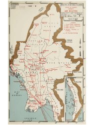
378 ECONOMIC AND ENGINEERING DEVELOPMENT OF BURMAby ferry. There are over 5,000 miles of navigable waterin the delta area; the Irrawaddy is navigable for 800miles of its length in <strong>Burma</strong>; the Chindwin for another400; and the Sittang and Salween are open to naviga¬tion for 350 and 50 miles of their respective lengths.But the only bridge crossing of any of these water¬ways, at present, is the combined rail and highwaystructure at Ava, south of Mandalay. This structure isnot in service, nor has it been since its partial demo¬lition in 1942. Except as the major connections aremade by ferries, the over-all system therefore consistsof a number of discontinuous pieces.As time goes on, and traffic develops, the need willarise for more adequate connection between all partsof the Union, and it is believed that the expandinghighway network will have to include at least twomore crossings of the Irrawaddy. The bridges to bebuilt upon the present system have been indicated. Inaddition, the population and traffic growth wUl neces¬sitate that crossings by bridge be provided over theIrrawaddy at Henzada, and between Magwe andMinbu.Ultimately, it is possible that the Irrawaddy wiUalso need to be bridged in the Myingyan region, andpossibly at Prome; that the improvement of a primaryhighway between Bhamo and Katha may require an¬other crossing of the Irrawaddy; and that the develop¬ment of the Kalewa area may necessitate the replace¬ment of the ferry over the Chindwin with a structure.Consideration should also be given to the possiblefuture hnks between parts of the road network whichare not adequately connected at present.Based on traffic considerations, the arrangement ofthe existing network, the needs of the agricultural andurban population, the topography, and other physicalfeatures, it is suggested that on a long-range basis, thefollowing extensions of the present primary systemshould be brought into being:(1) Improvement of district highway east fromRoute III, at Hsenwi, to the crossing of the Salweenat Kunlong, and on to Yunnan.(2) A connection to Route VIII, at its upper endnear Payagyi, extending westward to Tharrawaddy,on Route II, thence westward to and across the Irra¬waddy at Henzada to serve the secondary networknow existing west of the river.(3) Complete the link between Maubin and thesecondary system extending southward from Henzada.(4) A cross connection between Routes I and II, inthe Loikaw-Pyinmana region. Ultimately, it is be¬lieved that this should extend westward to Taung¬dwingyi and on to the Irrawaddy, with the river beingcrossed between Magwe and Minbu. The crossingwould be 218 river miles above Henzada, and fromMinbu to Mandalay is 203 river miles.(5) Construct a connection between Routes II andI, extending from Prome to Toungoo, and there con¬necting to the west end of Route V.(6) Extend the district road south from Maymyo toLawksawk; then improve the existing road to RouteIV, at Kalaw, or near Taunggyi.(7) Improve and complete the highway from Kathato Bhamo as an east-west link between the districthighways in that area.(8) Improve Route VII between Shwebo and Kale¬wa at the time that traffic has shown the need for thebridging of the Chindwin, at Kalewa.Judging from present trends, traffic and trade willdevelop in such order and to such degree that the im¬provements will become necessary in the order listed.Their construction, however, must also be integratedwith the bridge projects proposed earlier in this sub¬section. Other future needs will also manifest them¬selves as the traffic increases.7. HIGHWAYS TO ADJACENT COUNTRIESBecause of the topography and other physicalfeatures of this portion of southeast Asia, <strong>Burma</strong> ismore or less isolated from her neighbors, except bywater and air. The freight and bus traffic that at pres¬ent moves across her borders is of smaU volume andimportance. However, as the economy of the nationdevelops, and trade with close neighbors becomesnecessary and desirable, the traffic on the highwayroutes to the borders of adjacent countries wUl in¬crease in importance.At present only three national highways reach theborders of <strong>Burma</strong>, as trade gateways. Route VI ex¬tends from Pangsau Pass, on the Indian border, to theborder of Yunnan, east of Muse. The east end ofRoute IV is at Haung-Luk on the Indo-China bound¬ary. Route VII, northward from Mandalay, reachesEast Pakistan at Tamu.Along the lower reaches of Route VIII, how¬ever, there are several district and secondary roadswhich extend eastward to enter, or at least reach,Thailand. These are all of minor importance at presentbut should develop, as trade arteries, when trafficgrows and the roads themselves are improved. Theyinclude:(a) The Bilin Papun road, now 76 miles in length.Another 30 miles to the east, of which 22 are muletrack, reaches Dagwin, where the Salween River maybe crossed into ThaUand.(b) The Thaton-Hlaingbwe road, 48 miles in length.This includes a ferry crossing of the Salween atPa-an, and the route extends, as a mule track, toMyawadi, on the Thai border.(c) The Mudon-Kawkareik road also extends tothe Thai border, with a total length of 124 miles.