

8132 - NPCA SNF Watershed Report.indd - Niagara Peninsula ...
8132 - NPCA SNF Watershed Report.indd - Niagara Peninsula ...
8132 - NPCA SNF Watershed Report.indd - Niagara Peninsula ...

Create successful ePaper yourself
Turn your PDF publications into a flip-book with our unique Google optimized e-Paper software.
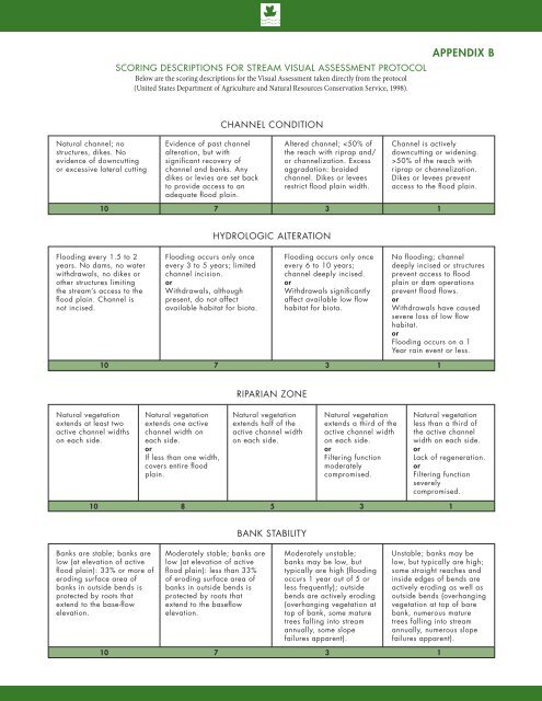
Scoring Descriptions for Stream Visual Assessment ProtocolBelow are the scoring descriptions for the Visual Assessment taken directly from the protocol(United States Department of Agriculture and Natural Resources Conservation Service, 1998).APPENDIX bCHANNEL CONDITIONNatural channel; nostructures, dikes. Noevidence of downcuttingor excessive lateral cuttingEvidence of past channelalteration, but withsignificant recovery ofchannel and banks. Anydikes or levies are set backto provide access to anadequate flood plain.Altered channel; 50% of the reach withriprap or channelization.Dikes or levees preventaccess to the flood plain.10 731HYDROLOGIC ALTERATIONFlooding every 1.5 to 2years. No dams, no waterwithdrawals, no dikes orother structures limitingthe stream’s access to theflood plain. Channel isnot incised.Flooding occurs only onceevery 3 to 5 years; limitedchannel incision.orWithdrawals, althoughpresent, do not affectavailable habitat for biota.Flooding occurs only onceevery 6 to 10 years;channel deeply incised.orWithdrawals significantlyaffect available low flowhabitat for biota.No flooding; channeldeeply incised or structuresprevent access to floodplain or dam operationsprevent flood flows.orWithdrawals have causedsevere loss of low flowhabitat.orFlooding occurs on a 1Year rain event or less.10 731RIPARIAN ZONENatural vegetationextends at least twoactive channel widthson each side.Natural vegetationextends one activechannel width oneach side.orIf less than one width,covers entire floodplain.Natural vegetationextends half of theactive channel widthon each side.Natural vegetationextends a third of theactive channel widthon each side.orFiltering functionmoderatelycompromised.Natural vegetationless than a third ofthe active channelwidth on each side.orLack of regeneration.orFiltering functionseverelycompromised.10 853 1BANK STABILITYBanks are stable; banks arelow (at elevation of activeflood plain): 33% or more oferoding surface area ofbanks in outside bends isprotected by roots thatextend to the base-flowelevation.Moderately stable; banks arelow (at elevation of activeflood plain): less than 33%of eroding surface area ofbanks in outside bends isprotected by roots thatextend to the baseflowelevation.Moderately unstable;banks may be low, buttypically are high (floodingoccurs 1 year out of 5 orless frequently); outsidebends are actively eroding(overhanging vegetation attop of bank, some maturetrees falling into streamannually, some slopefailures apparent).Unstable; banks may below, but typically are high;some straight reaches andinside edges of bends areactively eroding as well asoutside bends (overhangingvegetation at top of barebank, numerous maturetrees falling into streamannually, numerous slopefailures apparent).10 731


