

8132 - NPCA SNF Watershed Report.indd - Niagara Peninsula ...
8132 - NPCA SNF Watershed Report.indd - Niagara Peninsula ...
8132 - NPCA SNF Watershed Report.indd - Niagara Peninsula ...

Create successful ePaper yourself
Turn your PDF publications into a flip-book with our unique Google optimized e-Paper software.
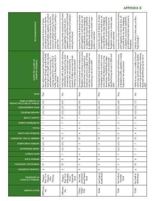
APPENDIX bSuspected Causes ofObserved ProblemsRecommendationsReach Number:General Locationin <strong>Watershed</strong>:Channel Condition:Hydrologic Alteration:Riparian Zone:Bank Stability:Water Appearance:Nutrient Enrichment:Barriers to Fish Movement:Instream Fish Cover:Pools:Invertebrate Habitat:Canopy Cover:Manure Presence:Riffle Embeddedness:Overall Score (Total dividedby number scored)RankNRThirteenMaNRTwelveMaTCMa/TCMb/TCTaTCMbTCMcTCMd<strong>Niagara</strong>River 13 at<strong>Niagara</strong>RiverParkway<strong>Niagara</strong>River 12 atWilloughbyDrive/SomervilleRoadTee Creekat MontroseRoad/YokomRoadTee Creek atKoabel RoadTee Creek atSchaubelRoadTee Creek atWhite Road663556101055310188558174577n/an/a33n/a7n/an/a35n/a710101010101013435411473317635711011110n/an/an/an/an/an/an/an/an/an/an/an/a3.66.94.64.74.87.2PoorFairPoorPoorPoorFairBare sediment exposed along bed & bank(stream flows through agricultural field);fairly high width to depth ratio indicatessedimentation may be occurring; 3crossings present (no culvert); lack ofbuffer, canopy & deep pools results inpoor habitatFairly high width to depth ratio indicatingsedimentation may be occurring; baresoil exposed in near bank zone; treesgrowing within the channel & thepresence of debris jams may indicatewidening; no deep pools presentEntrenched channel with limited access tofloodplain; banks are bare in some areas;the downstream was re-aligned by alandowner; presence of algae, oil sheen,and odour from disturbed sediment wasnoted during a site visit in 2007Entrenched channel with limited accessto floodplain; banks are bare in someareas; sediment deposition occurringdownstream of Koabel Road bridge;algae, duckweed, and turbid wateridentified during site visits in 2006 and2007Entrenched channel with limited accessto floodplain; buffer vegetation is mostlyherbaceous; few pools presentWetland area; trees in middle of channelwhich may indicate widening; blockedculvert may be contributing to widening;duckweed identified during site visit in2007Increase variety & diversity of nativeplant species to create a more diverseecological habitat; vegetation will controlthe amount of bank erosion & limit theamount of sediment entering the channel;crossings should be limited by creating aproper oneIncrease the variety and diversity of nativeplant vegetation in near bank zone;vegetation will control the amount of bankerosion and limit the amount of sedimententering the channelIncrease the variety & diversity of nativeplant vegetation in near bank zone; donot grade banks too steep (dredging)so vegetation can become established& stabilize banks (also need access tofloodplain); continue to monitor waterquality in watershedIncrease the variety & diversity of nativeplant vegetation in near bank zone; donot grade banks too steep (dredging)so vegetation can become established& stabilize bank (also need access tofloodplain); continue to monitor waterquality in watershedIncrease the variety and diversity of nativeplant vegetation in near bank zone; donot grade banks too steep (dredging)so vegetation can become establishedand stabilize bank (also need access tofloodplain)Unblock culvert so that water can flowfreely through it


