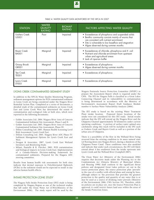
TABLE 4: WATER QUALITY DATA MONITORED BY THE <strong>NPCA</strong> IN 2007STATIONBIOMAPRATINGFACTORS AFFECTING WATER QUALITYUsshers CreekUS001WATERQUALITYRATINGPoorImpaired Bayer CreekBA001MarginalImpaired E. coli Grassy BrookGR001MarginalImpaired Tee CreekTE001MarginalImpaired Lyons CreekLY003MarginalImpaired Lyons Creek Contaminated Sediment StudyIn addition to the <strong>NPCA</strong>’s Water Quality Monitoring Program,sediment management options for PCB-contaminated sedimentin Lyons Creek are being considered under the <strong>Niagara</strong> RiverRemedial Action Plan. Completed as a series of documents, adetailed study of the contaminated sediments on Lyons CreekEast and Lyons Creek West has determined the extent ofcontamination and ecological risks at both sites, which werereported in the following documents:• Golder Associates Ltd. 2004. <strong>Niagara</strong> River Area of ConcernContaminated Sediment Site Assessment, Phase I and II.• Golder Associates Ltd. 2005. <strong>Niagara</strong> River Area of ConcernContaminated Sediment Site Assessment, Phase III.• Dillon Consulting Ltd. 2005. Human Health Screening LevelRisk Assessment: Lyon’s Creek East.• Dillion Consulting Ltd. 2005. <strong>Niagara</strong> River AOC Phase IV:Sediment Management Options for Lyon’s Creek East andWest.• Dougan & Associates. 2007. Lyon’s Creek East WetlandInventory and Monitoring Study.• Milani, Danielle & R. Fletcher. 2005. PCB contaminationand biological impacts in Lyons Creek East: Implementationof a Canada-Ontario Decision-making framework forcontaminated sediments. Prepared for the <strong>Niagara</strong> AOCsteering committee.Results from human health risk assessments for both sitesindicate that dermal exposure to Polychlorinated Biphenyls(PCBs) in the sediment would not be expected to result in anyadverse human health effects.Intake Protection Zone StudyThe <strong>Niagara</strong> Falls Intake Protection Zone (IPZ) study is beingcompleted by <strong>Niagara</strong> Region as one of the technical studiesthat fall under the Clean Water Act (CWA)(Ministry of theEnvironment 2006). The study report will be used by the<strong>Niagara</strong> <strong>Peninsula</strong> Source Protection Committee (NPSPC) toprepare the Assessment <strong>Report</strong> which is required under theCWA. The IPZ for <strong>Niagara</strong> Falls is classified as a Great LakesConnecting Channel and its vulnerability to contaminationis being determined in accordance with the Ministry ofEnvironment’s Assessment <strong>Report</strong> Draft Guidance Modulenumber 4: Surface Water Vulnerability Analysis (2006).The IPZ study is based on the existing Water TreatmentPlant intake location. Proposed future locations of theintake were not considered for this IPZ study. Initial resultsindicate that the IPZ will extend up the <strong>Niagara</strong> River and theChippawa Channel approximately 10 kilometres under currentoperating conditions. A portion of surface water upland areacatchments along this reach will be included in the IPZ suchas Usshers Creek and Bayers Creek as well as a portion of theurban area of Chippawa.There is a possibility of the flow in the Welland River beingreversed from the existing condition to its more natural state(of flowing down into <strong>Niagara</strong> River), during a shutdown of theChippawa Power Canal. These conditions were also modeledand indicate that under such circumstances, the IPZ will likelyextend about 4 km southwest from the intake upstream intoLyon’s Creek and the Welland River (Campbell 2007).The Clean Water Act (Ministry of the Environment 2006)requires that decisions made under the Planning Act or theCondominium Act (Ontario Ministry of Municipal Affairsand Housing 1998) shall conform to the significant threatpolicies and designated Great Lakes policies set out in thesource protection plans; the source protection plan ‘prevails’in the case of a conflict with official plans and zoning by-laws,although subject to ‘the provision that provides the greatestprotection to the quality and quantity of any water that is ormay be used as a source of drinking water prevails (Ministryof the Environment 2006, CWA Section 39). Therefore, whileno policies are in place yet, once the Source Protection Plan isapproved, it could restrict future land uses within the areas ofthe Intake Protection Zones.28
Groundwater ResourcesA Groundwater Study (Waterloo Hydrogeologic Inc.2005) hasbeen completed for the jurisdiction of the <strong>NPCA</strong>. The studyincludes a series of maps illustrating recharge/dischargeareas, well locations, overburden thickness, bedrock types,groundwater use, contaminant sources, and groundwatersusceptibility to contamination.Potential groundwater recharge and discharge areas areidentified on Figure 14. Discharge areas are locations wheregroundwater leaves the aquifer and flows to the surface.Groundwater discharge occurs where the water table (orpotentiometric surface) intersects the land surface. Potentialdischarge areas have been identified along Lyons Creek and aportion of Usshers Creek in the South <strong>Niagara</strong> Falls watershed.The potential height of the water table ranges between 0 and 50metres above the ground surface at these sites.Groundwater recharge areas are locations where water istransmitted downward to an aquifer. The amount of water thatinfiltrates to the water table depends on, for example, vegetationcover, slope, soil composition, surficial geology, and depth tothe water table. In the South <strong>Niagara</strong> Falls watershed potentialrecharge areas are located in the south-west portion of thewatershed. Water that infiltrates to the water table may carrycontaminants with it. Therefore, these areas are consideredgroundwater sensitive.Figure 15 illustrates areas with high, medium and low shallowintrinsic susceptibility. Two areas have been delineated ashaving a high shallow intrinsic susceptibility. The stretchalong the <strong>Niagara</strong> River has been delineated as having mediumsusceptibility. The area in and around Willoughby Marsh hasalso been delineated as an area with medium shallow intrinsicsusceptibility. The areas illustrated on Figure 15 are consideredvulnerable to groundwater contamination due to the type ofsoils and depth of the groundwater table.Additional studies should be conducted in this watershed toensure that current and future land uses do not conflict with theprotection of groundwater resources in susceptible areas, and toensure that planning authorities are adhering to the ProvincialPolicy Statement (Ontario Ministry of Municipal Affairs andHousing 2005b) which requires restrictions on development andsite alteration in order to protect “all municipal drinking watersupplies and designated vulnerable areas; and protect, improve,restore vulnerable surface water and ground water, sensitivesurface water features and sensitive ground water features, andtheir hydrologic functions (Ministry of the Environment 2006,CWA Section 39)”.Identification of Challengesand Opportunities in the South<strong>Niagara</strong> Falls <strong>Watershed</strong>The NWS (Regional Municipality of <strong>Niagara</strong> 2006) summarizeda list of key water protection issues in the South <strong>Niagara</strong> Fallswatershed. Additional issues have been identified by residentsliving in the watershed via public open houses and workshopsduring the Fall of 2006 and early in 2007. A Land Managementand Agricultural Best Management Practice survey (AppendixA) helped to identify land and water management issues inrural areas of the watershed. Descriptions of the challengesfacing the South <strong>Niagara</strong> Falls watershed are reported here.Septic SystemsA well designed septic system can function properly for years.The basic design of a septic system includes a septic tank anda drainage field. Wastewater from toilets, bathtubs, sinks andother drains flows into the tank where bacteria that is naturallyfound in the wastewater breaks down any solid material. Theliquid effluent travels through the perforated distribution pipesto the leaching bed. The water is then absorbed and filtered bythe ground in the drainage field. Problems with septic tanksoften stem from improper use and maintenance. Faulty septicsystems can create serious local contamination problems withthe potential to contaminate groundwater wells (PollutionProbe 2004).Faulty or improperly maintained septic systems have beenreported as a slight to moderate concern in the Land ManagementIssues and Agricultural Best Management Practices survey.A septic system maintenance and education program couldimprove local septic system operation and well water qualityfor groundwater users in the watershed. The watershed strategywill put forth a set of recommendations for this type of waterquality initiative.Landfill SitesThere are 2 known closed landfill sites in the South <strong>Niagara</strong>Falls watershed. Landfill sites labelled as “old dump/fillsites” are areas that were once used as a dump or landfill.Although these sites are known to have existed, they are notmonitored for their impact on water quality (Michaud PersonalCommunication <strong>NPCA</strong> 2006). One of the closed landfill sites islocated in the Lyons Creek subwatershed off of Young Road andthe other known closed landfill is located in the Bayers Creeksubwatershed on Sherk Road. The locations of these landfillsites are located on Figure 14. No other known dump/fill sitesare located in the watershed.Road SaltOriginating from salt storage and snow disposal sites as wellas from runoff, road salts are an environmental concernbecause they are known to have an adverse effect on freshwaterecosystems, soil, vegetation and wildlife (Environment Canada2004a). In April 2004, Environment Canada produced a Code ofPractice for the Environmental Management of Road Salts. TheCode of Practice recommends that all road authorities prepareand implement salt management plans that incorporate theimplementation of best management practices (BMP) for saltapplication, salt storage and handling, and snow disposal. Thebenefits of improved salt management include:• a reduction in corrosive damage to salt application equipment,vehicles, and infrastructure such as concrete sidewalks andsteps;• a reduction in salt damage to vegetation and surroundingroads and walkways;• reduced salt releases to surrounding waterways; and• an overall, more efficient and effective service resulting insafer roads and sidewalks for users (Environment Canada2004b).The Regional Municipality of <strong>Niagara</strong> undertook a SaltVulnerability Study, which was completed by Ecoplans Ltd(2005). The study identified vulnerable areas for land use,groundwater, surface water, and natural areas. In the South29