

8132 - NPCA SNF Watershed Report.indd - Niagara Peninsula ...
8132 - NPCA SNF Watershed Report.indd - Niagara Peninsula ...
8132 - NPCA SNF Watershed Report.indd - Niagara Peninsula ...

Create successful ePaper yourself
Turn your PDF publications into a flip-book with our unique Google optimized e-Paper software.
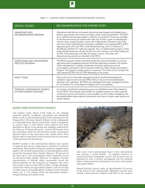
Table 11: Usshers Creek Subwatershed Restoration ActionsSPECIAL STUDIESRECOMMENDATIONS FOR FURTHER STUDYABANDONED WELLDECOMMISSIONING PROGRAMAGRICULTURAL BEST MANAGEMENTPRACTICES PROGRAMPOLICY TOOLSPOTENTIAL CONTAMINANT SOURCESOF POINT SOURCE POLLUTIONAbandoned wells that are not properly decommissioned (capped and sealed) pose athreat to groundwater resources by providing a direct route to groundwater. The <strong>NPCA</strong>has a well decommissioning program in place for its jurisdiction. Grants are availablefor the decommissioning of unused water wells only. Priority is given to hydrologicallysensitive areas, projects located in areas with a high density of domestic water wells,and areas where watershed plans have been completed or are ongoing (<strong>NPCA</strong> 2007).Approved grants will cover 90% of well decommissioning costs to a maximum of$2,000 per well (limit of 2 wells per property). This is a reimbursement program, whichmeans that the landowner will pay the full cost to the contractor, and will be reimbursedfor 90% of the total project cost after all receipts, invoices, and water welldecommissioning records are submitted to the <strong>NPCA</strong>.The <strong>NPCA</strong>’s program aimed at educating landowners about the benefits of rural andagricultural best management practices should be extensively promoted in the UsshersCreek subwatershed. In addition, landowners should be made aware of andencouraged to participate in the Conservation Authority’s Water Quality ImprovementProgram. This program provides grants to a maximum 75% of the cost of a project withcaps between $5,000 and $12,000 depending on the project.Policy tools such as stormwater management policies should be developed andincluded in regional and municipal Official Plans to ensure environmentally-basedplanning in the watershed. The <strong>NPCA</strong> has developed stormwater management policiesfor its jurisdiction for use by Regional <strong>Niagara</strong> and its municipalities.An inventory of potential contaminant sources was identified as part of the objectivesfor the <strong>NPCA</strong>’s Groundwater Study (2005). An updated inventory to confirm potentialcontaminant sources and locations is recommended as well as further investigation intothe potential effects these potential contaminants may have on surface water quality andaquatic habitat.Bayers Creek Restoration StrategyLike Usshers Creek, Bayers Creek works its way throughscattered wetlands, woodlands, agricultural and abandonedfields as well as rural residential areas before draining into the<strong>Niagara</strong> River. The main channel of Bayers Creek is designatedas a municipal drain; Boyers Creek Drain, which is designatedas critical (Type 1) fish habitat. Grass pickerel have beenidentified in Bayers Creek during fish sampling conducted bythe Ministry of Natural Resources. Several fish barriers havebeen identified within the subwatershed, mainly consisting oflog jams, debris in the watercourse and a failed culvert. Suchbarriers affect stream flow as well as prevent the free movementof fish upstream and downstream.BioMAP samples in this subwatershed indicate water qualityis impaired and species composition is indicative of nutrientenrichment. Water quality testing also indicates marginal waterquality with elevated concentrations of total phosphorus whichexceed the Provincial Water Quality Objective 100 percent ofthe time and E. Coli concentrations which frequently exceedthe Provincial Water Quality Objective. In addition, elevatedconcentrations of chloride which occasionally exceed thefederal guideline for the protection of irrigation water havebeen noted in Bayers Creek (<strong>NPCA</strong> 2007a). Sewage discharge,runoff from urban and agricultural landuse, and soil erosionare likely sources of total phosphorus in Bayers Creek. Potentialsources for E. Coli include urban and agricultural landuse,sewage discharge and animal waste.Like Lyons Creek subwatershed, Bayers Creek subwatershedalso contains a closed landfill. An updated inventory toconfirm potential contaminant sources and locations may bebeneficial as well as further investigation into the potentialeffects of these potential contaminants on surface water qualityand aquatic habitat.Natural heritage features make up approximately 30 percentof the Bayers Creek subwatershed. Significant natural areasinclude a small portion of Black Creek PSW in the southern78


