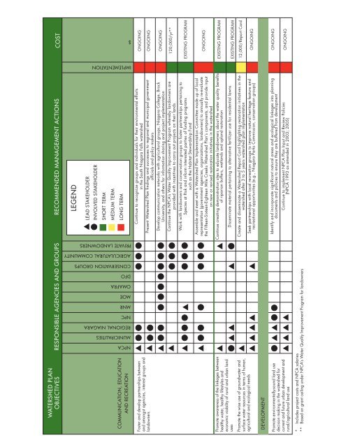
WATERSHED PLANOBJECTIVESRESPONSIBLE AGENCIES AND GROUPS RECOMMENDED MANAGEMENT ACTIONS COST<strong>NPCA</strong>MUNICIPALITIESREGIONAL NIAGARANPCMNRMOEOMAFRADFOCONSERVATION GROUPSAGRICULATURAL COMMUNITYPRIVATE LANDOWNERSIMPLEMENTATION$COMMUNICATION, EDUCATIONAND RECREATIONLEGENDLEAD STAKEHOLDERINVOLVED STAKEHOLDERSHORT TERMMEDIUM TERMLONG TERMFoster and develop partnerships betweenand amongst agencies, interest groups andlandownersPromote awareness of the linkages betweenhealthy water, healthy lifestyles andeconomic viability of rural and urban landusesPromote the wise use of groundwater andsurface water resources in terms of human,agricultural and ecological needsContinue to recognize groups and individuals for their environmental effortsin the South <strong>Niagara</strong> Falls watershedPresent <strong>Watershed</strong> Plan findings and successes to regional and municipal governmentofficials and policy makersDevelop communication networks with agricultural groups, <strong>Niagara</strong> College, BrockUniversity, and others for information sharing and project implementationContinue the <strong>NPCA</strong>’s Water Quality Improvement Program whereby landowners areprovided with incentives to carry out projects on their landsWork with landowners and conservation groups to foster partnerships pertaining toSpecies at Risk and inform interested parties of funding programssuch as the Habitat Stewardship FundAssemble and meet with a <strong>Watershed</strong> Plan Implementation Committee made up of localrepresentation (government agencies, organizations, landowners) to annually re-evaluatethe Fifteen-Sixteen-Eighteen Mile Creeks <strong>Watershed</strong> Plan’s components, and provide inputon new or revised restoration initiatives in the watershedContinue creating demonstration sites to educate landowners about the water quality benefitsof riparian buffers, wetlands and upland restorationDisseminate material pertaining to alternative fertilizer use for residential lawnsCreate and disseminate a <strong>Watershed</strong> <strong>Report</strong> Card highlighting restoration initiatives in thewatershed after 3 to 5 years watershed plan implementationSeek partnerships with local recreation groups to improve natural heritage feature andrecreational opportunities (e.g., <strong>Niagara</strong> Parks Commission, conservation groups)ONGOINGONGOINGONGOING120,000/yr**EXISTING PROGRAMONGOINGEXISTING PROGRAMEXISTING PROGRAM12,000/<strong>Report</strong> CardONGOINGDEVELOPMENTPromote environmentally-sound land usedecision making in the watershed forcurrent and future urban development andrural/agricultural land useIdentify and incorporate significant natural areas and ecological linkages into planningdocuments and policies to ensure they are buffered from developmentContinue to implement <strong>NPCA</strong> Plan Input and Review Policies(<strong>NPCA</strong> 1993 as amended in 2003; 2005)ONGOINGONGOING* Includes project costs and <strong>NPCA</strong> salaries** Based on grant ceiling under <strong>NPCA</strong>’s Water Quality Improvement Program for landowners92
The recommended actions have also been identified in terms oftheir implementation. Green denotes short term implementation,yellow represents medium term implementation and red is usedto indicate long term implementation. For example, projectsthat are ongoing are almost always implemented over the longterm and are therefore, represented in red. Projects that havespecific funding requirements or require approvals, for example,are often represented in green and yellow, thereby indicatingshort term or medium term implementation respectively.MonitoringMonitoring serves two purposes in watershed planning.Monitoring is required to update the watershed plan as landuses change and new issues are identified, and monitoringalso serves to measure the success of restoration projects interms of enhancing and protecting water quality for all usersin a watershed. Monitoring the achievement of a watershedplan’s objectives involves continually reviewing the South<strong>Niagara</strong> Falls <strong>Watershed</strong> Plan. The Plan will be reviewedby the <strong>NPCA</strong> Restoration Team and the South <strong>Niagara</strong> Falls<strong>Watershed</strong> Plan Implementation Committee (comprised ofpublic interest groups, watershed municipalities, agency, andcitizen representatives) annually. As part of the review process,the plan will be amended whenever necessary to reflect thechanging environmental, economic, technical, or social trendswithin the jurisdiction of the <strong>NPCA</strong>, and more specificallywithin the South <strong>Niagara</strong> Falls watershed. A complete reviewand necessary revisions will occur ever 5 years.In addition to monitoring the objectives or outcomes of the<strong>Watershed</strong> Plan, the monitoring process includes measuringthe performance and success of the management actions usedto achieve the objectives. In this regard, monitoring serves tocollect and analyze aquatic, terrestrial and socio-economic datato identify changes in the watershed; both from restorationactivities, and growth and development. This component of themonitoring program should include:• Water quality sampling, benthic studies (BioMap), andwater temperature monitoring through the <strong>NPCA</strong>’s WaterQuality Monitoring Program. This data can be used as anindicator of whether or not the recommendations providedin the <strong>Watershed</strong> Plan have maintained and/or improvedthe physical and chemical characteristics of water quality inthe watershed. Continued groundwater monitoring shouldalso be included as part of the water quality monitoringprogram.• On-going classification of vegetative communities usingstandardized protocols (Ecological Land Classification).These habitat areas are recorded as Geographic InformationSystem layers and are updated bi-annually to evaluate changesin community composition, habitat size and fragmentation.• Biological life assessments (qualitative and quantitative)such as insects/pollinators, fish and birds.• A compilation of the number and location of BMPsimplemented in the watershed. This will also include pollutantloading reduction measurements. This information will behoused in a restoration database and updated as projects arecompleted.• <strong>Watershed</strong> landowners should also be surveyed (at least every5 years prior to the <strong>Watershed</strong> Plan review) to help watershedplanners and the restoration team identify new watershedissues, and evaluate changes in knowledge and behaviour.Land use and land use change in the watershed will also beevaluated. This can be completed using the Agricultural Non-Point Source Pollution (AGNPS) model. AGNPS is a computermodel that is used for evaluating the effect of managementdecisions impacting a watershed system, such as predictingnonpoint source pollutant loadings within agriculturalwatersheds. For example, AGNPS can simulate the effects ofvarious management practices on pollution in the watershed.The model can predict where runoff from rain, snowmelt,or irrigation may carry pesticides, fertilizers, or sedimentthroughout a watershed. The AGNPS model should be amendedas land use change occurs, especially when those changes donot coincide with future land use planning.TIME FRAMEMonthly during ice free season(March-October)YearlyTypically every 3 years (spring and fall)5 Year ReviewContinuous MonitoringContinuous MonitoringACTIONSurface water quality samplingProject Monitoring: photos and notes of restoration projects aretaken to document status of project (i.e., improvements, growth,change)Biological Monitoring and Assessment Program samplingReview of the watershed plan: Investigation of identified issuesand status of recommended actions is completed. Any new issueswill be identified and an updated restoration strategy will becreated.Landowners are given a monitoring journal to document anychanges they observe occurring in the project area.Update Natural Heritage Information Database and GIS layers toreflect Natural Heritage Areas Inventory field surveys and projectfindings.Table 15: <strong>Watershed</strong> Monitoring Schedule93