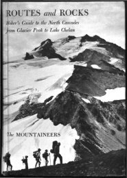
Routes and rocks; hiker's guide to the North Cascades from ... - USGS
Routes and rocks; hiker's guide to the North Cascades from ... - USGS
Routes and rocks; hiker's guide to the North Cascades from ... - USGS
- No tags were found...

You also want an ePaper? Increase the reach of your titles
YUMPU automatically turns print PDFs into web optimized ePapers that Google loves.
SUIATTLE RIVER 25Follow <strong>the</strong> talus <strong>and</strong> <strong>the</strong> hea<strong>the</strong>r- <strong>and</strong> needle-carpeted slopes beyonddown <strong>to</strong> <strong>the</strong> outlet stream of LOWER BATH LAKE (5650). Campinghere is adequate but cannot compare <strong>to</strong> that of <strong>the</strong> uppermost BathLake.From <strong>the</strong> outlet climb (north-nor<strong>the</strong>ast) up <strong>the</strong> ridge rimming <strong>the</strong>lake, keeping in hea<strong>the</strong>ry swales free of huckleberry brush. This ridgebecomes broad <strong>and</strong> open above, where <strong>the</strong>re is a pile of large blocks.Directly above this talus is a steep, shallow, grubby gully, much used bygame, which leads <strong>to</strong> benches above UPPER BATH LAKE (5950-6hours). Bath Lake is a delightful spot with a perfect combination of bluewater, white rock, <strong>and</strong> green hea<strong>the</strong>r. For those who like spectacularpanoramic views, a short climb <strong>to</strong> <strong>the</strong> ridge <strong>to</strong>p brings immediate satisfaction.The lake is well-s<strong>to</strong>cked with fish <strong>and</strong> seldom visited.A longer alternate <strong>to</strong> <strong>the</strong> main <strong>and</strong> easiest route <strong>to</strong> Bath Lakes goesvia <strong>the</strong> two high lakes east of Sulphur Mountain. From <strong>the</strong> flat meadowsnorth of Sulphur Mountain (5750) climb talus <strong>and</strong> hea<strong>the</strong>r southward <strong>to</strong><strong>the</strong> pass (6450) east of Sulphur Mountain. Drop down an easy spur <strong>to</strong> agood camp spot perched on a knoll overlooking <strong>the</strong> FIRST UNNAMEDLAKE (5800-4% hours). Water seeps <strong>from</strong> <strong>the</strong> grass on <strong>the</strong> south side of<strong>the</strong> knoll. Descend very steep hea<strong>the</strong>r <strong>to</strong> <strong>the</strong> lake <strong>and</strong> cross <strong>the</strong> outlet onlogs. Bounce an echo here. Traverse <strong>and</strong> climb south (right) along aledge of hea<strong>the</strong>r <strong>and</strong> scree <strong>to</strong> <strong>the</strong> crest of <strong>the</strong> irregular broken spur whichforms <strong>the</strong> east wall of <strong>the</strong> lake chasm. There is an old burn on <strong>the</strong> lowerpart of this small spur. Brush <strong>and</strong> small trees can be avoided by climbingeast <strong>to</strong>ward <strong>the</strong> main spur ridge with its apron of talus. Climb nor<strong>the</strong>ast<strong>to</strong>ward a broad saddle (6650-5 Vfe hours) on this main spur; this saddleis <strong>the</strong> only good passage through <strong>the</strong> sheer granite cliffs whose jointsare so wonderfully displayed. To reach pleasant lakeside camping spotswith nice views of Glacier Peak, go down along <strong>the</strong> <strong>to</strong>p of <strong>the</strong> main spur<strong>to</strong> a broad smooth shoulder (6300) <strong>and</strong> drop over rounded hillocks <strong>to</strong><strong>the</strong> south side of <strong>the</strong> SECOND UNNAMED LAKE (5900-6 hours). Torejoin <strong>the</strong> main route <strong>to</strong> Bath Lakes, traverse <strong>and</strong> climb nor<strong>the</strong>astward,avoiding cliffs by not climbing <strong>to</strong>o high. Head for <strong>the</strong> grassy swale(6650-6 hours) on <strong>the</strong> tree-spotted spur crossed by <strong>the</strong> main route.Follow <strong>the</strong> main route <strong>from</strong> <strong>the</strong> outlet of <strong>the</strong> uppermost Bath Lake.Go easterly around <strong>the</strong> north side <strong>and</strong> up a sharp nose dotted withgroves of alpine fir. Cross filled-in pockets where tiny, s<strong>and</strong>y meadowsare as smooth <strong>and</strong> flat as billiard tables. Swing sou<strong>the</strong>astward on approachingspur summits <strong>and</strong> talus <strong>and</strong> traverse prominent benches(game trails) <strong>to</strong> <strong>the</strong> main ridge (6750).From here on <strong>to</strong> Canyon Lake <strong>the</strong> route traverses <strong>the</strong> south side of