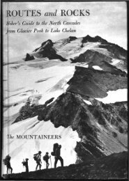
Routes and rocks; hiker's guide to the North Cascades from ... - USGS
Routes and rocks; hiker's guide to the North Cascades from ... - USGS
Routes and rocks; hiker's guide to the North Cascades from ... - USGS
- No tags were found...

Create successful ePaper yourself
Turn your PDF publications into a flip-book with our unique Google optimized e-Paper software.
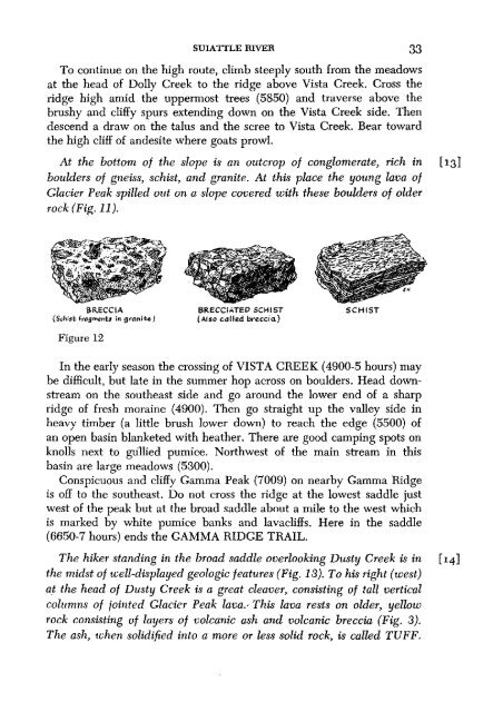
SUIATTLE RIVER 33To continue on <strong>the</strong> high route, climb steeply south <strong>from</strong> <strong>the</strong> meadowsat <strong>the</strong> head of Dolly Creek <strong>to</strong> <strong>the</strong> ridge above Vista Creek. Cross <strong>the</strong>ridge high amid <strong>the</strong> uppermost trees (5850) <strong>and</strong> traverse above <strong>the</strong>brushy <strong>and</strong> cliffy spurs extending down on <strong>the</strong> Vista Creek side. Thendescend a draw on <strong>the</strong> talus <strong>and</strong> <strong>the</strong> scree <strong>to</strong> Vista Creek. Bear <strong>to</strong>ward<strong>the</strong> high cliff of <strong>and</strong>esite where goats prowl.At <strong>the</strong> bot<strong>to</strong>m of <strong>the</strong> slope is an outcrop of conglomerate, rich inboulders of gneiss, schist, <strong>and</strong> granite. At this place <strong>the</strong> young lava ofGlacier Peak spilled out on a slope covered with <strong>the</strong>se boulders of olderrock (Fig. 11).[13]BRJECCIA(Schist fragments in granite )Figure 12BRECCIATED SCHIST(Also called breccia)SCHISTIn <strong>the</strong> early season <strong>the</strong> crossing of VISTA CREEK (4900-5 hours) maybe difficult, but late in <strong>the</strong> summer hop across on boulders. Head downstreamon <strong>the</strong> sou<strong>the</strong>ast side <strong>and</strong> go around <strong>the</strong> lower end of a sharpridge of fresh moraine (4900). Then go straight up <strong>the</strong> valley side inheavy timber (a little brush lower down) <strong>to</strong> reach <strong>the</strong> edge (5500) ofan open basin blanketed with hea<strong>the</strong>r. There are good camping spots onknolls next <strong>to</strong> gullied pumice. <strong>North</strong>west of <strong>the</strong> main stream in thisbasin are large meadows (5300).Conspicuous <strong>and</strong> cliffy Gamma Peak (7009) on nearby Gamma Ridgeis off <strong>to</strong> <strong>the</strong> sou<strong>the</strong>ast. Do not cross <strong>the</strong> ridge at <strong>the</strong> lowest saddle justwest of <strong>the</strong> peak but at <strong>the</strong> broad saddle about a mile <strong>to</strong> <strong>the</strong> west whichis marked by white pumice banks <strong>and</strong> lavacliffs. Here in <strong>the</strong> saddle(6650-7 hours) ends <strong>the</strong> GAMMA RIDGE TRAIL.The hiker st<strong>and</strong>ing in <strong>the</strong> broad saddle overlooking Dusty Creek is in<strong>the</strong> midst of well-displayed geologic features (Fig. 13). To his right (west)at <strong>the</strong> head of Dusty Creek is a great cleaver, consisting of tall verticalcolumns of jointed Glacier Peak lava.- This lava rests on older, yellowrock consisting of layers of volcanic ash <strong>and</strong> volcanic breccia (Fig. 3).The ash, when solidified in<strong>to</strong> a more or less solid rock, is called TUFF.[14!