BOURARHET SUD
BOURARHET SUD
BOURARHET SUD
- No tags were found...

Create successful ePaper yourself
Turn your PDF publications into a flip-book with our unique Google optimized e-Paper software.
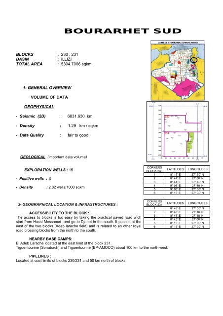
<strong>BOURARHET</strong> <strong>SUD</strong>BLOCKS : 230 , 231BASIN: ILLIZITOTAL AREA : 5304.7066 sqkm1- GENERAL OVERVIEWVOLUME OF DATAGEOPHYSICAL- Seismic (2D) : 6831.630 km- Density : 1.29 km / sqkm- Data Quality : fair to goodGEOLOGICAL (important data volume)EXPLORATION WELLS : 15- Positive wells : 5- Density : 2.82 wells/1000 sqkm2- GEOGRAPHICAL LOCATION & INFRASTRUCTURES :ACCESSIBILITY TO THE BLOCK :The access to blocks is too easy by taking the practical paved road wichstart from Hassi Messaoud and go to Djanet in the south. It passes at theeast of the two blocks (Adeb larache field) and is related to an other royalroad crossing blocks from the north to the south.CORNERSBLOCK 230LATITUDES LONGITUDES1 8° 15’ E 27° 50’ N2 8° 44’ E 27°50’ N3 8° 44’ E 27° 40’ N4 9° 05’ E 27°40’ N5 9° 05’ E 27° 30’ N6 8° 15’ E 27° 30’ NCORNERSBLOCK 231LATITUDES LONGITUDES1 8° 48’ E 27° 30’ N2 8° 48’ E 27°18’ N3 8° 45’ E 27°18’ N4 8° 45’ E 27°00’ N5 8° 15’ E 27° 00’ N6 8° 15’ E 27° 30’ NNEARBY BASE CAMPS:El Adeb Larache located at the east limit of the block 231.Tiguentourine (Sonatrach) and Tiguentourine (BP-AMOCO) about 100 km to the north west.PIPELINES :Located at east limits of blocks 230/231 and 50 km north of blocks.
3- PETROLEUM SYSTEM :- SOURCE ROCKS:FORMATION TOC (%) MATURATION GENERATION/EXPULSIONSilurian hot shales 0.4 - 8.9 WET GASLower Carboniferous -CretaceousFrasnian hot shalesLower Carboniferous -(Middle to UpperDevonian)0.4 - 5.5 OIL WINDOW Cretaceous- RESERVOIR ROCKS:RESERVOIR/AGERESERVOIR FACIESPETROPHYSICAL PARAMETERSPorosity (%) PERMEABILITY (mD)F-2 (Strunian) Deltaic system 10 - 30 0.1 - 500F-6 (C3/C1)Lower DevonianOrdovician (IV)Fluvial system withMarine incursions.Braided delta plain, deltafront (minor channels) atthe top; unstable front andprodelta (mouth bar) at themedium; braid plain todistal prodelta at the base.4 - 19 0.1 - 62 - 100.1 - 16Ordovician (III)Shoals and storm wavedominated + extensiveshallow marine platformwith tide influence.3 – 100.1 – 83Cambrian (II)* Proximal tide-dominated3 - 11shelf(*) JUST 4 WELLS ABOUT 15 REACHED THE CAMBRIAN II UNIT.0.1 - 400
PETROLEUM RESULTS1. BLOCK 231WELLS YEAR RESERVOIRS PETROLEUM RESULTSF2 : 1.9 m 3 water (S=147g/l) + Gas showsDevonianF4 : Gas shows + water (S=21.7 g/l)F5 : Gas shows + 7m 3 water (S=33.9 g/l)F6 : fresh waterTXE-11962(C.F.P.A.)OrdovicianCarboniferousIV : 10 m 3 Gas + 3.6m 3 (S=174 g/l)III-3 : 2.5 m 3 GasIII-2 : Gas shows + 7m 3 water (S=76-88.5g/l)21 l water (S=7.8 g/l)TXF-1 1962DevonianTXF-2 1962 DevonianTXF-3 1963 DevonianTX-1 1959DevonianF2 : 40 000m 3 /j dry gasF4 : gas + fresh waterF5 : Gas + oil shows + 15 m 3 /h water(S=10 g/l)F6 : 3.5 m 3 gas + oil showsF2 : 75 000 m 3 /j Gas+ 100l water (S=95g/l)F4 : Gas shows + 3.6 m 3 water (S=41 g/l)F6 : 1 m 3 /h gas + oil shows + 6.65 m 3(S=0.7 g/l)F2 : 50 000 m 3 /j GasF4 : 1.5 m 3 water (S=37.7g/l)F5 : 5.7 m 3 water (S=34g/l)F6 : 1.3 m 3 gas + oil shows +7m 3 water(S=0.3g/l)F2 : Gas + 20 l water (S=33g/l)F4 : 21 l water (S=20g/l)F5 : oil and gas shows + 20 l water(S=25g/l)
1. BLOCK 230WELLS YEAR RESERVOIRS PETROLEUM RESULTSILM-11997PEDCO-SHDevonianF6 : dryF2 : 1770.7 m 3 Gas + 0.5 m 3 oilDevonianF4 : 0.5 l mud ( S.R)GAH-1 1986F6 : DryZT-11963CREPSRML-1 1984IHSW-1 1989OrdovicianDevonianOrdovicianDevonianOrdovicianDevonianWeak gas flowF2 : salt water (S=158g/l)F4 : salt water (S=53g/l)F6 : fresh water15-25 m 3 /h gasF4 : dryF6 (C3) : dryF6 (C2) : 2 l Oil/CE + 4m 3 fresh waterIV-3 : 2146m 3 /h gas + 2 l gazoline (CE)IV-2 : dryIII-2 : 200 l oil + 1.7m 3 water (S=200g/l)F4 : dryF6 (C3) : 100 l oil (CE)F6 (C2) : 13 m 3 fresh water (CE)TXC-1TXC-2TX-2TXD-11963CFP(A)1963CFP(A)1960CFP(A)1963CFP(A)OrdovicianDevonianDevonianDevonianDevonianIII-2 : 6m 3 water (S=69 g/l)F2 : mud + water (S=54 g/l)F4 : dryF6 : secF2 : dryF4 : dryF6 : 380 l mud + gas and oil /T + 1.7m 3water (S=1.9g/l)F2 : dryF4 : dryF2 : gas and oil / TF4 : oil / TF6 (C3) : oil / TF6 (C2) : 3m 3 water (S=10.2g/l)/TSEALS :Silurian shales ensure the cover of Ordovician reservoirs. Middle and Upper Devonian shales (Frasnian)ensure the cover of Lower Devonian F6 (unit C). F2 reservoir (Strunian) is capped by Carboniferous shales.TRAP STYLES : Structural and combined (diagenetic component).DISCOVERIES : -NUMBER OF PROSPECTS AT THE PRESENT TIME : One prospect in block 231 (TZL).Average drilling depth : 2500 m (unit II : deepest formation).Average of main target (Ordovician unit IV) : 2250 m.
PARAMETERSTIN TARZOULI (Ordovician prospect)Area sqkm 35Amplitude m 40Net/Gross m/m 80Porosity % 5-10HYDROCARBON TYPE : Oil and gasAVERAGE DRILLING COST : 1200 US $ / m ( main target / Ordovician )AVERAGE 2D SEISMIC COST : 5000 US $ / km4- BLOCKS PROSPECTIVITYOrdovician, Strunian “F2” and lower Devonian “F6” are the main targets within the blocks 230 / 231.Cambrian Unit II and Carboniferous sands if capped are also prospective.Fifteen exploration wells were drilled in the area and five (5) showed good petroleum results.Proximity of producing fields mainly in the eastern part make the area interesting in terms of development.This area (southern part) is still under explored with the possibility of trap styles different from the structuralone.