Amsterdam 2040
Amsterdam 2040
Amsterdam 2040
- No tags were found...

Create successful ePaper yourself
Turn your PDF publications into a flip-book with our unique Google optimized e-Paper software.
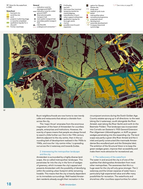
17 Vision for the waterfrontin <strong>2040</strong>Waterfrontlive/work mixwork/live mixworkprojects in planning stageor recently completedqualitative impulse for acity parkFormer naval baseGeneralindicative route foraboveground HQPTindicative route for undergroundHQPTinternational publictransport hubmain public transport hubsecondary public transporthubnew ferry linkunderground connection**P+R facilitysea lock2nd ocean liner terminaltemporary berths forinland shippingintensification of porturban support enterprisesqualitative impulse forborough centremarinapossible zone for portexpansionA/Boption for OlympicGames sitestudy area*regional cycle routebeachmetropolitan placerecreational programmeproposed naturedevelopmentwaterside developmentCompass Island andcycle bridge* / ** See notes on page 09.1718Buurt neighbourhoods are now home to new trendycafés and restaurants that attract a clientele fromacross the city.This ‘major thrust’ emanates from the enormousmagnetism of the heart of <strong>Amsterdam</strong> for countlesspeople, enterprises and institutions. However, thescarcity of space means that people are always forcedto search a little further out: first in the 19th-centurydistricts adjacent to the city centre, then in the surroundingbelt of development realized in the 1920s to1940s, and now the ‘city-centre milieu’ is spreadingout across the IJ waterway and towards Zuidas.2 Interweaving the metropolitan landscapeand the city<strong>Amsterdam</strong> is surrounded by a highly diverse landscape,the so-called metropolitan landscape. Thispenetrates far into the city in the form of wedgesof greenery, which increase the city’s appeal andpresents <strong>Amsterdam</strong> with the possibility of densifyingwithin the existing urban footprint while remainingliveable. This means that the city is heavily dependenton its immediate surroundings. Well-heeled <strong>Amsterdam</strong>residents already sought their recreation in thePLAN<strong>Amsterdam</strong>circumjacent environs during the Dutch Golden Age.Country estates sprung up in all directions: to the west(along the IJ waterway), south (alongside the RiverAmstel), east (along the River Vecht) and north (in theBeemster Polder). That landscape was incorporatedinto Cornelis van Eesteren’s 1935 General ExtensionPlan (Algemeen Uitbreidingsplan, or AUP) as greenwedges penetrating into the expanding city. The landscapewas partly a given (the River Amstel and the IJinlet) and partly constructed (the manmade <strong>Amsterdam</strong>seBos woodland park and the Sloterplas lake).The ambition of the Structural Vision is to keep thegreen wedges green, improve their accessibility andmake them more attractive for recreational use.3 The rediscovery of the waterfrontThe water in and around the city is of one of thequalities that distinguishes <strong>Amsterdam</strong> from mostother metropolises. The awareness that this is ahuge asset for the city will only grow stronger. The IJwaterway and the IJmeer expanse of water have aparticularly high experiential value and offer manypossibilities for recreation. The waterfronts andshorelines offer countless opportunities for urban