NDMA Annual Report 2011 (26MB)
NDMA Annual Report 2011 (26MB)
NDMA Annual Report 2011 (26MB)

You also want an ePaper? Increase the reach of your titles
YUMPU automatically turns print PDFs into web optimized ePapers that Google loves.
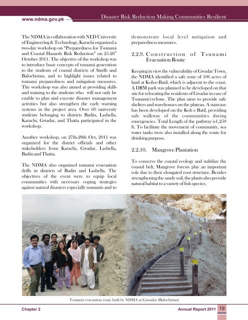
www.ndma.gov.pkDisaster Risk Reduction Making Communities ResilientThe <strong>NDMA</strong> in collaboration with NED Universityof Engineering & Technology, Karachi organized atwo-day workshop on “Preparedness for Tsunamithand Coastal Hazards Risk Reduction” on 25-26October <strong>2011</strong>. The objective of the workshop wasto introduce basic concepts of tsunami generationto the students of coastal districts of Sindh andBalochistan, and to highlight issues related totsunami preparedness and mitigation measures.The workshop was also aimed at providing skillsand training to the students who will not only beenable to plan and execute disaster managementactivities but also strengthen the early warningsystems in the project area. Over 60 universitystudents belonging to districts Badin, Lasbella,Karachi, Gwadar, and Thatta participated in theworkshop.Another workshop, on 27th-28th Oct, <strong>2011</strong> wasorganized for the district officials and otherstakeholders from Karachi, Gwadar, Lasbella,Badin and Thatta.The <strong>NDMA</strong> also organized tsunami evacuationdrills in districts of Badin and Lasbella. Theobjectives of the event were to equip localcommunities with necessary coping strategiesagainst natural disasters especially tsunamis and todemonstrate local level mitigation andpreparedness measures.2.2.9. Construction of TsunamiEvacuation RouteKeeping in view the vulnerability of Gwadar Town,the <strong>NDMA</strong> identified a safe zone of 106 acres ofland at Koh-e-Batil, which is adjacent to the coast.A DRM park was planned to be developed on thatsite for relocating the residents of Gwadar in case ofTsunami/cyclone. The plan aims to provide safeshelters and warehouses on the plateau. A staircasehas been developed on the Koh e Batil, providingsafe walkway of the communities duringemergencies. Total Length of the pathway is1,250ft. To facilitate the movement of community, seawater tanks were also installed along the route fordrinking purpose.2.2.10. Mangrove PlantationTo conserve the coastal ecology and stabilize thecoastal belt, Mangrove forests play an importantrole due to their elongated root structure. Besidesstrengthening the sandy soil, the plants also providenatural habitat to a variety of fish species.Tsunami evacuation route built by <strong>NDMA</strong> at Gawadar (Balochistan)Chapter 2<strong>Annual</strong> <strong>Report</strong> <strong>2011</strong> 19