Park Woodlawn Area Plan - Charlotte-Mecklenburg County
Park Woodlawn Area Plan - Charlotte-Mecklenburg County
Park Woodlawn Area Plan - Charlotte-Mecklenburg County
- No tags were found...

Create successful ePaper yourself
Turn your PDF publications into a flip-book with our unique Google optimized e-Paper software.
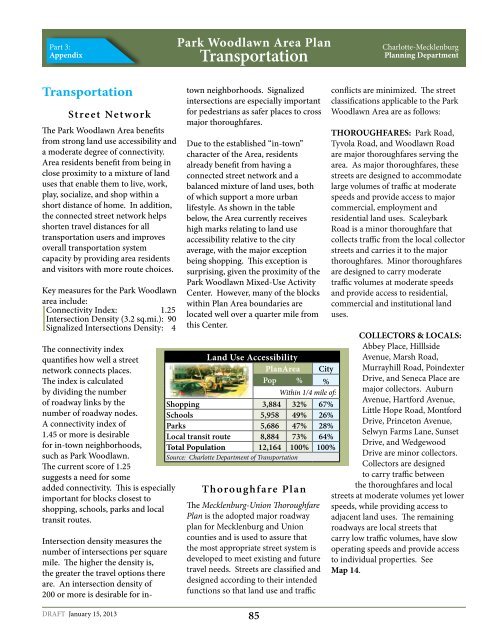
Part 3:Appendix<strong>Park</strong> <strong>Woodlawn</strong> <strong>Area</strong> <strong>Plan</strong>Transportation<strong>Charlotte</strong>-<strong>Mecklenburg</strong><strong>Plan</strong>ning DepartmentTransportationStreet NetworkThe <strong>Park</strong> <strong>Woodlawn</strong> <strong>Area</strong> benefitsfrom strong land use accessibility anda moderate degree of connectivity.<strong>Area</strong> residents benefit from being inclose proximity to a mixture of landuses that enable them to live, work,play, socialize, and shop within ashort distance of home. In addition,the connected street network helpsshorten travel distances for alltransportation users and improvesoverall transportation systemcapacity by providing area residentsand visitors with more route choices.Key measures for the <strong>Park</strong> <strong>Woodlawn</strong>area include:Connectivity Index: 1.25Intersection Density (3.2 sq.mi.): 90Signalized Intersections Density: 4The connectivity indexquantifies how well a streetnetwork connects places.The index is calculatedby dividing the numberof roadway links by thenumber of roadway nodes.A connectivity index of1.45 or more is desirablefor in-town neighborhoods,such as <strong>Park</strong> <strong>Woodlawn</strong>.The current score of 1.25suggests a need for someadded connectivity. This is especiallyimportant for blocks closest toshopping, schools, parks and localtransit routes.Intersection density measures thenumber of intersections per squaremile. The higher the density is,the greater the travel options thereare. An intersection density of200 or more is desirable for intownneighborhoods. Signalizedintersections are especially importantfor pedestrians as safer places to crossmajor thoroughfares.Due to the established “in-town”character of the <strong>Area</strong>, residentsalready benefit from having aconnected street network and abalanced mixture of land uses, bothof which support a more urbanlifestyle. As shown in the tablebelow, the <strong>Area</strong> currently receiveshigh marks relating to land useaccessibility relative to the cityaverage, with the major exceptionbeing shopping. This exception issurprising, given the proximity of the<strong>Park</strong> <strong>Woodlawn</strong> Mixed-Use ActivityCenter. However, many of the blockswithin <strong>Plan</strong> <strong>Area</strong> boundaries arelocated well over a quarter mile fromthis Center.Land Use Accessibility<strong>Plan</strong><strong>Area</strong>CityPop % %Within 1/4 mile of:Shopping 3,884 32% 67%Schools 5,958 49% 26%<strong>Park</strong>s 5,686 47% 28%Local transit route 8,884 73% 64%Total Population 12,164 100% 100%Source: <strong>Charlotte</strong> Department of TransportationThoroughfare <strong>Plan</strong>The <strong>Mecklenburg</strong>-Union Thoroughfare<strong>Plan</strong> is the adopted major roadwayplan for <strong>Mecklenburg</strong> and Unioncounties and is used to assure thatthe most appropriate street system isdeveloped to meet existing and futuretravel needs. Streets are classified anddesigned according to their intendedfunctions so that land use and trafficconflicts are minimized. The streetclassifications applicable to the <strong>Park</strong><strong>Woodlawn</strong> <strong>Area</strong> are as follows:THOROUGHFARES: <strong>Park</strong> Road,Tyvola Road, and <strong>Woodlawn</strong> Roadare major thoroughfares serving thearea. As major thoroughfares, thesestreets are designed to accommodatelarge volumes of traffic at moderatespeeds and provide access to majorcommercial, employment andresidential land uses. ScaleybarkRoad is a minor thoroughfare thatcollects traffic from the local collectorstreets and carries it to the majorthoroughfares. Minor thoroughfaresare designed to carry moderatetraffic volumes at moderate speedsand provide access to residential,commercial and institutional landuses.COLLECTORS & LOCALS:Abbey Place, HilllsideAvenue, Marsh Road,Murrayhill Road, PoindexterDrive, and Seneca Place aremajor collectors. AuburnAvenue, Hartford Avenue,Little Hope Road, MontfordDrive, Princeton Avenue,Selwyn Farms Lane, SunsetDrive, and WedgewoodDrive are minor collectors.Collectors are designedto carry traffic betweenthe thoroughfares and localstreets at moderate volumes yet lowerspeeds, while providing access toadjacent land uses. The remainingroadways are local streets thatcarry low traffic volumes, have slowoperating speeds and provide accessto individual properties. SeeMap 14.DRAFT January 15, 201385