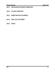
Nationwide Permit 14 Summary - Nebraska Department of Roads
Nationwide Permit 14 Summary - Nebraska Department of Roads
Nationwide Permit 14 Summary - Nebraska Department of Roads

You also want an ePaper? Increase the reach of your titles
YUMPU automatically turns print PDFs into web optimized ePapers that Google loves.
The following general conditions must be followed in orderfor any authorization by a NWP to be valid:General ConditionsPark Service, U.S. Forest Service, Bureau <strong>of</strong> LandManagement, U.S. Fish and Wildlife Service).1. Navigation. No activity may cause more than aminimal adverse effect on navigation.2. Proper Maintenance. Any structure or fillauthorized shall be properly maintained, includingmaintenance to ensure public safety.3. Soil Erosion and Sediment Controls.Appropriate soil erosion and sediment controlsmust be used and maintained in effectiveoperating condition during construction, and allexposed soil and other fills, as well as any workbelow the ordinary high water mark or high tideline, must be permanently stabilized at the earliestpracticable date. <strong>Permit</strong>tees are encouraged toperform work within waters <strong>of</strong> the United Statesduring periods <strong>of</strong> low-flow or no-flow.4. Aquatic Life Movements. No activity maysubstantially disrupt the necessary life-cyclemovements <strong>of</strong> those species <strong>of</strong> aquatic lifeindigenous to the waterbody, including thosespecies which normally migrate through the area,unless the activity's primary purpose is to impoundwater. Culverts placed in streams must beinstalled to maintain low flow conditions.5. Equipment. Heavy equipment working inwetlands must be placed on mats, or othermeasures must be taken to minimize soildisturbance.6. Regional and Case-By-Case Conditions. Theactivity must comply with any regional conditionswhich may have been added by the DivisionEngineer (see 33 CFR 330.4(e)) and with anycase specific conditions added by the Corps or bythe State or tribe in its Section 401 water qualitycertification.7. Wild and Scenic Rivers. No activity may occur ina component <strong>of</strong> the National Wild and Scenic RiverSystem; or in a river <strong>of</strong>ficially designated byCongress as a “study river'' for possible inclusionin the system, while the river is in an <strong>of</strong>ficial studystatus; unless the appropriate Federal agency,with direct management responsibility for suchriver, has determined in writing that the proposedactivity will not adversely affect the Wild andScenic River designation, or study status.Information on Wild and Scenic Rivers may beobtained from the appropriate Federal landmanagement agency in the area (e.g., National8. Tribal Rights. No activity or its operation mayimpair reserved tribal rights, including, but notlimited to, reserved water rights and treaty fishingand hunting rights.9. Water Quality(a) In certain States and tribal lands an individual401 water quality certification must be obtainedor waived (See 33 CFR 330.4(c)).(b) For NWPs 12, <strong>14</strong>, 17, 18, 32, 39, 40, 42, 43,and 44, where the State or tribal 401certification (either generically or individually)does not require or approve a water qualitymanagement plan, the permittee must includedesign criteria and techniques that will ensurethat the authorized work does not result inmore than minimal degradation <strong>of</strong> waterquality. An important component <strong>of</strong> a waterquality management plan includes stormwatermanagement that minimizes degradation <strong>of</strong> thedownstream aquatic system, including waterquality. Refer to General Condition 21 forstormwater management requirements.Another important component <strong>of</strong> a waterquality management plan is the establishmentand maintenance <strong>of</strong> vegetated buffers next toopen waters, including streams. Refer toGeneral Condition 19 for vegetated bufferrequirements for the NWPs.10. Coastal Zone Management. In certain states, anindividual state coastal zone managementconsistency concurrence must be obtained orwaived (see Section 330.4(d)).11. Endangered Species(a) No activity is authorized under any NWP whichis likely to jeopardize the continued existence<strong>of</strong> a threatened or endangered species or aspecies proposed for such designation, asidentified under the Federal EndangeredSpecies Act, or which will destroy or adverselymodify the critical habitat <strong>of</strong> such species.Non-federal permittees shall notify the DistrictEngineer if any listed species or designatedcritical habitat might be affected or is in thevicinity <strong>of</strong> the project, or is located in thedesignated critical habitat and shall not beginwork on the activity until notified by the DistrictEngineer that the requirements <strong>of</strong> the
Endangered Species Act have been satisfiedand that the activity is authorized. Foractivities that may affect Federally-listedendangered or threatened species ordesignated critical habitat, the notification mustinclude the name(s) <strong>of</strong> the endangered orthreatened species that may be affected by theproposed work or that utilize the designatedcritical habitat that may be affected by theproposed work. As a result <strong>of</strong> formal orinformal consultation with the FWS or NMFS,the District Engineer may add species-specificregional endangered species conditions to theNWPs.(b) Authorization <strong>of</strong> an activity by a nationwidepermit does not authorize the ``take'' <strong>of</strong> athreatened or endangered species as definedunder the Federal Endangered Species Act. Inthe absence <strong>of</strong> separate authorization (e.g., anESA Section 10 <strong>Permit</strong>, a Biological Opinionwith "incidental take" provisions, etc.) from theU.S. Fish and Wildlife Service or the NationalMarine Fisheries Service, both lethal and nonlethal``takes'' <strong>of</strong> protected species are inviolation <strong>of</strong> the Endangered Species Act.Information on the location <strong>of</strong> threatened andendangered species and their critical habitatcan be obtained directly from the <strong>of</strong>fices <strong>of</strong> theU.S. Fish and Wildlife Service and NationalMarine Fisheries Service or their world wideweb pages athttp://www.fws.gov/r9endspp/endspp.html andhttp://www.nfms.gov/prot__res/esahome.html,respectively.12. Historic Properties. No activity which may affecthistoric properties listed, or eligible for listing, inthe National Register <strong>of</strong> Historic Places isauthorized, until the District Engineer has compliedwith the provisions <strong>of</strong> 33 CFR part 325,Appendix C. The prospective permittee must notifythe District Engineer if the authorized activity mayaffect any historic properties listed, determined tobe eligible, or which the prospective permittee hasreason to believe may be eligible for listing on theNational Register <strong>of</strong> Historic Places, and shall notbegin the activity until notified by the DistrictEngineer that the requirements <strong>of</strong> the NationalHistoric Preservation Act have been satisfied andthat the activity is authorized. Information on thelocation and existence <strong>of</strong> historic resources can beobtained from the State Historic PreservationOffice and the National Register <strong>of</strong> Historic Places(see 33 CFR 330.4(g)). For activities that mayaffect historic properties listed in, or eligible forlisting in, the National Register <strong>of</strong> Historic Places,the notification must state which historic propertymay be affected by the proposed work or include avicinity map indicating the location <strong>of</strong> the historicproperty.13. Notification(a) Timing: Where required by the terms <strong>of</strong> theNWP, the prospective permittee must notifythe District Engineer with a preconstructionnotification (PCN) as early as possible. TheDistrict Engineer must determine if thenotification is complete within 30 days <strong>of</strong> thedate <strong>of</strong> receipt and can request additionalinformation necessary to make the PCNcomplete only once. However, if theprospective permittee does not provide all <strong>of</strong>the requested information, then the DistrictEngineer will notify the prospective permitteethat the notification is still incomplete and thePCN review process will not commence untilall <strong>of</strong> the requested information has beenreceived by the District Engineer. Theprospective permittee shall not begin theactivity:(1) Until notified in writing by the DistrictEngineer that the activity may proceedunder the NWP with any special conditionsimposed by the District or DivisionEngineer; or(2) If notified in writing by the District orDivision Engineer that an individual permitis required; or(3) Unless 45 days have passed from theDistrict Engineer's receipt <strong>of</strong> the completenotification and the prospective permitteehas not received written notice from theDistrict or Division Engineer.Subsequently, the permittee's right toproceed under the NWP may be modified,suspended, or revoked only in accordancewith procedure set forth in 33 CFR330.5(d)(2).(b) Contents <strong>of</strong> Notification: The notification mustbe in writing and include the followinginformation:(1) Name, address, and telephone numbers <strong>of</strong>the prospective permittee;(2) Location <strong>of</strong> the proposed project;(3) Brief description <strong>of</strong> the proposed project;the project's purpose; direct and indirect
adverse environmental effects the projectwould cause; any other NWP(s), regionalgeneral permit(s), or individual permit(s)used or intended to be used to authorizeany part <strong>of</strong> the proposed project or anyrelated activity. Sketches should beprovided when necessary to show that theactivity complies with the terms <strong>of</strong> theNWP (sketches usually clarify the projectand when provided result in a quickerdecision);(4) For NWPs 7, 12, <strong>14</strong>, 18, 21, 34, 38, 39, 40,41, 42, and 43, the PCN must also includea delineation <strong>of</strong> affected special aquaticsites, including wetlands, vegetatedshallows (e.g., submerged aquaticvegetation, seagrass beds), and riffle andpool complexes (see paragraph 13(f));(5) For NWP 7 (Outfall Structures andMaintenance), the PCN must includeinformation regarding the original designcapacities and configurations <strong>of</strong> thoseareas <strong>of</strong> the facility where maintenancedredging or excavation is proposed;(6) For NWP <strong>14</strong> (Linear TransportationProjects), the PCN must include acompensatory mitigation proposal to <strong>of</strong>fsetpermanent losses <strong>of</strong> waters <strong>of</strong> the U.S.and a statement describing how temporarylosses <strong>of</strong> waters <strong>of</strong> the U.S. will beminimized to the maximum extentpracticable;(7) For NWP 21 (Surface Coal MiningActivities), the PCN must include an Office<strong>of</strong> Surface Mining (OSM) or state-approvedmitigation plan, if applicable. To beauthorized by this NWP, the DistrictEngineer must determine that the activitycomplies with the terms and conditions <strong>of</strong>the NWP and that the adverseenvironmental effects are minimal bothindividually and cumulatively and mustnotify the project sponsor <strong>of</strong> thisdetermination in writing;(8) For NWP 27 (Stream and WetlandRestoration Activities), the PCN mustinclude documentation <strong>of</strong> the priorcondition <strong>of</strong> the site that will be reverted bythe permittee;(9) For NWP 29 (Single-Family Housing), thePCN must also include:(i) Any past use <strong>of</strong> this NWP by theindividual permittee and/or thepermittee's spouse;(ii) A statement that the single-familyhousing activity is for a personalresidence <strong>of</strong> the permittee;(iii) A description <strong>of</strong> the entire parcel,including its size, and a delineation <strong>of</strong>wetlands. For the purpose <strong>of</strong> thisNWP, parcels <strong>of</strong> land measuring 1/4acre or less will not require a formalon-site delineation. However, theapplicant shall provide an indication <strong>of</strong>where the wetlands are and theamount <strong>of</strong> wetlands that exists on theproperty. For parcels greater than 1/4acre in size, a formal wetlanddelineation must be prepared inaccordance with the current methodrequired by the Corps. (See paragraph13(f));(iv) A written description <strong>of</strong> all land(including, if available, legaldescriptions) owned by theprospective permittee and/or theprospective permittee's spouse, withina one mile radius <strong>of</strong> the parcel, in anyform <strong>of</strong> ownership (including any landowned as a partner, corporation, jointtenant, co-tenant, or as a tenant-bythe-entirety)and any land on which apurchase and sale agreement or othercontract for sale or purchase has beenexecuted;(10) For NWP 31 (Maintenance <strong>of</strong> ExistingFlood Control Facilities), the prospectivepermittee must either notify the DistrictEngineer with a PCN prior to eachmaintenance activity or submit a five year(or less) maintenance plan. In addition,the PCN must include all <strong>of</strong> the following:(i)Sufficient baseline information so as toidentify the approved channel depthsand configurations and existingfacilities. Minor deviations areauthorized, provided the approvedflood control protection or drainage isnot increased;(ii) A delineation <strong>of</strong> any affected specialaquatic sites, including wetlands; and,
(iii) Location <strong>of</strong> the dredged materialdisposal site.(11)For NWP 33 (Temporary Construction,Access, and Dewatering), the PCN mustalso include a restoration plan <strong>of</strong>reasonable measures to avoid andminimize adverse effects to aquaticresources;(12)For NWPs 39, 43, and 44, the PCN mustalso include a written statement to theDistrict Engineer explaining how avoidanceand minimization for losses <strong>of</strong> waters <strong>of</strong>the U.S. were achieved on the project site;(13)For NWP 39 and NWP 42, the PCN mustinclude a compensatory mitigationproposal that <strong>of</strong>fsets unavoidable losses <strong>of</strong>waters <strong>of</strong> the United States or justificationexplaining why compensatory mitigationshould not be required. For dischargesthat cause the loss <strong>of</strong> greater than 300linear feet <strong>of</strong> an intermittent streambed, tobe authorized, the District Engineer mustdetermine that the activity complies withthe other terms and conditions <strong>of</strong> the NWP,determine adverse environmental effectsare minimal both individually andcumulatively, and waive the limitation onstream impacts in writing before thepermittee may proceed;(<strong>14</strong>)For NWP 40 (Agricultural Activities), thePCN must include a compensatorymitigation proposal to <strong>of</strong>fset losses <strong>of</strong>waters <strong>of</strong> the United States. This NWPdoes not authorize the relocation <strong>of</strong> greaterthan 300 linear-feet <strong>of</strong> existing serviceabledrainage ditches constructed in non-tidalstreams unless, for drainage ditchesconstructed in intermittent non-tidalstreams, the District Engineer waives thiscriterion in writing, and the DistrictEngineer has determined that the projectcomplies with all terms and conditions <strong>of</strong>this NWP, and that any adverse impacts <strong>of</strong>the project on the aquatic environment areminimal, both individually and cumulatively;(15)For NWP 43 (Stormwater ManagementFacilities), the PCN must include, for theconstruction <strong>of</strong> new stormwatermanagement facilities, a maintenance plan(in accordance with State and localrequirements, if applicable) and acompensatory mitigation proposal to <strong>of</strong>fsetlosses <strong>of</strong> waters <strong>of</strong> the United States. Fordischarges that cause the loss <strong>of</strong> greaterthan 300 linear feet <strong>of</strong> an intermittentstreambed, to be authorized, the DistrictEngineer must determine that the activitycomplies with the other terms andconditions <strong>of</strong> the NWP, determine adverseenvironmental effects are minimal bothindividually and cumulatively, and waivethe limitation on stream impacts in writingbefore the permittee may proceed;(16)For NWP 44 (Mining Activities), the PCNmust include a description <strong>of</strong> all waters <strong>of</strong>the United States adversely affected by theproject, a description <strong>of</strong> measures taken tominimize adverse effects to waters <strong>of</strong> theUnited States, a description <strong>of</strong> measurestaken to comply with the criteria <strong>of</strong> theNWP, and a reclamation plan (foraggregate mining activities in isolatedwaters and non-tidal wetlands adjacent toheadwaters and any hard rock/mineralmining activities);(17)For activities that may adversely affectFederally-listed endangered or threatenedspecies, the PCN must include thename(s) <strong>of</strong> those endangered orthreatened species that may be affected bythe proposed work or utilize the designatedcritical habitat that may be affected by theproposed work.(18)For activities that may affect historicproperties listed in, or eligible for listing in,the National Register <strong>of</strong> Historic Places,the PCN must state which historic propertymay be affected by the proposed work orinclude a vicinity map indicating thelocation <strong>of</strong> the historic property.(c) Form <strong>of</strong> Notification: The standard individualpermit application form (Form ENG 4345) maybe used as the notification but must clearlyindicate that it is a PCN and must include all <strong>of</strong>the information required in (b)(1)-(18) <strong>of</strong>General Condition 13. A letter containing therequisite information may also be used.(d) District Engineer's Decision: In reviewing thePCN for the proposed activity, the DistrictEngineer will determine whether the activityauthorized by the NWP will result in more thanminimal individual or cumulative adverseenvironmental effects or may be contrary tothe public interest. The prospective permittee
to provide the Corps multiple copies <strong>of</strong>notifications to expedite agency notification.(f) Wetlands Delineations: Wetlands delineationsmust be prepared in accordance with thecurrent method required by the Corps. (ForNWP 29 see paragraph (b)(9)(iii) for parcelsless than 1/4-acre in size.) The permittee mayask the Corps to delineate the special aquaticsite. There may be some delay if the Corpsdoes the delineation. Furthermore, the 45-dayperiod will not start until the wetlanddelineation has been completed and submittedto the Corps, where appropriate.<strong>14</strong>. Compliance Certification. Every permittee whohas received a <strong>Nationwide</strong> permit verification fromthe Corps will submit a signed certificationregarding the completed work and any requiredmitigation. The certification will be forwarded bythe Corps with the authorization letter. Thecertification will include:(a) A statement that the authorized work was donein accordance with the Corps authorization,including any general or specific conditions;(b) A statement that any required mitigation wascompleted in accordance with the permitconditions;(c) The signature <strong>of</strong> the permittee certifying thecompletion <strong>of</strong> the work and mitigation.15. Use <strong>of</strong> Multiple <strong>Nationwide</strong> <strong>Permit</strong>s. The use <strong>of</strong>more than one NWP for a single and completeproject is prohibited, except when the acreage loss<strong>of</strong> waters <strong>of</strong> the United States authorized by theNWPs does not exceed the acreage limit <strong>of</strong> theNWP with the highest specified acreage limit. Forexample, if a road crossing over tidal waters isconstructed under NWP <strong>14</strong>, with associated bankstabilization authorized by NWP 13, the maximumacreage loss <strong>of</strong> waters <strong>of</strong> the United States for thetotal project cannot exceed 1/3 acre.16. Water Supply Intakes. No activity, includingstructures and work in navigable waters <strong>of</strong> theUnited States or discharges <strong>of</strong> dredged or fillmaterial, may occur in the proximity <strong>of</strong> a publicwater supply intake except where the activity is forrepair <strong>of</strong> the public water supply intake structuresor adjacent bank stabilization.17. Shellfish Beds. No activity, including structuresand work in navigable waters <strong>of</strong> the United Statesor discharges <strong>of</strong> dredged or fill material, may occurin areas <strong>of</strong> concentrated shellfish populations,unless the activity is directly related to a shellfishharvesting activity authorized by NWP 4.18. Suitable Material. No activity, including structuresand work in navigable waters <strong>of</strong> the United Statesor discharges <strong>of</strong> dredged or fill material, mayconsist <strong>of</strong> unsuitable material (e.g., trash, debris,car bodies, asphalt, etc.) and material used forconstruction or discharged must be free from toxicpollutants in toxic amounts (see Section 307 <strong>of</strong> theClean Water Act).19. Mitigation. The District Engineer will consider thefactors discussed below when determining theacceptability <strong>of</strong> appropriate and practicablemitigation necessary to <strong>of</strong>fset adverse effects onthe aquatic environment that are more thanminimal.(a) The project must be designed and constructedto avoid and minimize adverse effects towaters <strong>of</strong> the United States to the maximumextent practicable at the project site (i.e., onsite).(b) Mitigation in all its forms (avoiding, minimizing,rectifying, reducing or compensating) will berequired to the extent necessary to ensure thatthe adverse effects to the aquatic environmentare minimal.(c) Compensatory mitigation at a minimum onefor-oneratio will be required for all wetlandimpacts requiring notification, unless theDistrict Engineer determines in writing thatsome other form <strong>of</strong> mitigation would be moreenvironmentally appropriate and provides aproject-specific waiver <strong>of</strong> this requirement.Consistent with National policy, the DistrictEngineer will establish a preference forrestoration <strong>of</strong> wetlands as compensatorymitigation, with preservation used only inexceptional circumstances.(d) Compensatory mitigation (i.e., replacement orsubstitution <strong>of</strong> aquatic resources for thoseimpacted) will not be used to increase theacreage losses allowed by the acreage limits<strong>of</strong> some <strong>of</strong> the NWPs. For example, 1/4-acre<strong>of</strong> wetlands cannot be created to change a 3/4-acre loss <strong>of</strong> wetlands to a 1/2-acre lossassociated with NWP 39 verification.However, 1/2-acre <strong>of</strong> created wetlands can beused to reduce the impacts <strong>of</strong> a 1/2-acre loss<strong>of</strong> wetlands to the minimum impact level inorder to meet the minimal impact requirementassociated with NWPs.
(e) To be practicable, the mitigation must beavailable and capable <strong>of</strong> being doneconsidering costs, existing technology, andlogistics in light <strong>of</strong> the overall project purpose.Examples <strong>of</strong> mitigation that may beappropriate and practicable include, but arenot limited to: reducing the size <strong>of</strong> the project;establishing and maintaining wetland or uplandvegetated buffers to protect open waters suchas streams; and replacing losses <strong>of</strong> aquaticresource functions and values by creating,restoring, enhancing, or preserving similarfunctions and values, preferably in the samewatershed.(f) Compensatory mitigation plans for projects inor near streams or other open waters willnormally include a requirement for theestablishment, maintenance, and legalprotection (e.g., easements, deed restrictions)<strong>of</strong> vegetated buffers to open waters. In manycases, vegetated buffers will be the onlycompensatory mitigation required. Vegetatedbuffers should consist <strong>of</strong> native species. Thewidth <strong>of</strong> the vegetated buffers required willaddress documented water quality or aquatichabitat loss concerns. Normally, the vegetatedbuffer will be 25 to 50 feet wide on each side <strong>of</strong>the stream, but the District Engineer mayrequire slightly wider vegetated buffers toaddress documented water quality or habitatloss concerns. Where both wetlands and openwaters exist on the project site, the Corps willdetermine the appropriate compensatorymitigation (e.g., stream buffers or wetlandscompensation) based on what is best for theaquatic environment on a watershed basis. Incases where vegetated buffers are determinedto be the most appropriate form <strong>of</strong>compensatory mitigation, the District Engineermay waive or reduce the requirement toprovide wetland compensatory mitigation forwetland impacts.(g) Compensatory mitigation proposals submittedwith the notification may be either conceptualor detailed. If conceptual plans are approvedunder the verification, then the Corps willcondition the verification to require detailedplans be submitted and approved by the Corpsprior to construction <strong>of</strong> the authorized activityin waters <strong>of</strong> the United States.(h) <strong>Permit</strong>tees may propose the use <strong>of</strong> mitigationbanks, in-lieu fee arrangements or separateactivity-specific compensatory mitigation. In allcases that require compensatory mitigation,the mitigation provisions will specify the partyresponsible for accomplishing and/orcomplying with the mitigation plan.20. Spawning Areas. Activities, including structuresand work in navigable waters <strong>of</strong> the United Statesor discharges <strong>of</strong> dredged or fill material, inspawning areas during spawning seasons must beavoided to the maximum extent practicable.Activities that result in the physical destruction(e.g., excavate, fill, or smother downstream bysubstantial turbidity) <strong>of</strong> an important spawningarea are not authorized.21. Management <strong>of</strong> Water Flows. To the maximumextent practicable, the activity must be designed tomaintain preconstruction downstream flowconditions (e.g., location, capacity, and flow rates).Furthermore, the activity must not permanentlyrestrict or impede the passage <strong>of</strong> normal orexpected high flows (unless the primary purpose <strong>of</strong>the fill is to impound waters) and the structure ordischarge <strong>of</strong> dredged or fill material must withstandexpected high flows. The activity must, to themaximum extent practicable, provide for retainingexcess flows from the site, provide for maintainingsurface flow rates from the site similar topreconstruction conditions, and provide for notincreasing water flows from the project site,relocating water, or redirecting water flow beyondpreconstruction conditions. Stream channelizationwill be reduced to the minimal amount necessary,and the activity must, to the maximum extentpracticable, reduce adverse effects such asflooding or erosion downstream and upstream <strong>of</strong>the project site, unless the activity is part <strong>of</strong> alarger system designed to manage water flows. Inmost cases, it will not be a requirement to conductdetailed studies and monitoring <strong>of</strong> water flow.This condition is only applicable to projects thathave the potential to affect water flows. Whileappropriate measures must be taken, it is notnecessary to conduct detailed studies to identifysuch measures or require monitoring to ensuretheir effectiveness. Normally, the Corps will deferto state and local authorities regardingmanagement <strong>of</strong> water flow.22. Adverse Effects from Impoundments. If theactivity creates an impoundment <strong>of</strong> water, adverseeffects to the aquatic system due to theacceleration <strong>of</strong> the passage <strong>of</strong> water, and/or therestriction <strong>of</strong> its flow, shall be minimized to themaximum extent practicable. This includesstructures and work in navigable waters <strong>of</strong> the
United States, or discharges <strong>of</strong> dredged or fillmaterial.23. Waterfowl Breeding Areas. Activities, includingstructures and work in navigable waters <strong>of</strong> theUnited States or discharges <strong>of</strong> dredged or fillmaterial, into breeding areas for migratorywaterfowl must be avoided to the maximum extentpracticable.24. Removal <strong>of</strong> Temporary Fills. Any temporary fillsmust be removed in their entirety and the affectedareas returned to their preexisting elevation.25. Designated Critical Resource Waters. Criticalresource waters include, NOAA-designated marinesanctuaries, National Estuarine ResearchReserves, National Wild and Scenic Rivers, criticalhabitat for Federally listed threatened andendangered species, coral reefs, State naturalheritage sites, and outstanding national resourcewaters or other waters <strong>of</strong>ficially designated by aState as having particular environmental orecological significance and identified by the DistrictEngineer after notice and opportunity for publiccomment. The District Engineer may alsodesignate additional critical resource waters afternotice and opportunity for comment.(a) Except as noted below, discharges <strong>of</strong> dredgedor fill material into waters <strong>of</strong> the United Statesare not authorized by NWPs 7, 12, <strong>14</strong>, 16, 17,21, 29, 31, 35, 39, 40, 42, 43, and 44 for anyactivity within, or directly affecting, criticalresource waters, including wetlands adjacentto such waters. Discharges <strong>of</strong> dredged or fillmaterials into waters <strong>of</strong> the United States maybe authorized by the above NWPs in NationalWild and Scenic Rivers if the activity complieswith General Condition 7. Further, suchdischarges may be authorized in designatedcritical habitat for Federally listed threatened orendangered species if the activity complieswith General Condition 11 and the U.S. Fishand Wildlife Service or the National MarineFisheries Service has concurred in adetermination <strong>of</strong> compliance with thiscondition.impacts to the critical resource waters will beno more than minimal.26. Fills Within 100-Year Floodplains. For purposes<strong>of</strong> this general condition, 100-year floodplains willbe identified through the Federal EmergencyManagement Agency's (FEMA) Flood InsuranceRate Maps or FEMA-approved local floodplainmaps.(a) Discharges in Floodplain; Below Headwaters:Discharges <strong>of</strong> dredged or fill material intowaters <strong>of</strong> the United States within the mapped100-year floodplain, below headwaters (i.e.five cfs), resulting in permanent above-gradefills, are not authorized by NWPs 39, 40, 42,43 and 44.(b) Discharges in Floodway; Above Headwaters:Discharges <strong>of</strong> dredged or fill material intowaters <strong>of</strong> the United States within the FEMA orlocally mapped floodway, resulting inpermanent above-grade fills, are notauthorized by NWPs 39, 40, 42, and 44.(c) The permittee must comply with any applicableFEMA-approved state or local floodplainmanagement requirements.27. Construction Period. For activities that have notbeen verified by the Corps and the project wascommenced or under contract to commence by theexpiration date <strong>of</strong> the NWP (or modification orrevocation date), the work must be completedwithin 12 months after such date (including anymodification that affects the project).For activities that have been verified and theproject was commenced or under contract tocommence within the verification period, the workmust be completed by the date determined by theCorps.For projects that have been verified by the Corps,an extension <strong>of</strong> a Corps approved completion datemay be requested. This request must be submittedat least one month before the previously approvedcompletion date.(b) For NWPs 3, 8, 10, 13, 15, 18, 19, 22, 23, 25,27, 28, 30, 33, 34, 36, 37, and 38, notificationis required in accordance with GeneralCondition 13, for any activity proposed in thedesignated critical resource waters includingwetlands adjacent to those waters. The DistrictEngineer may authorize activities under theseNWPs only after he determines that the