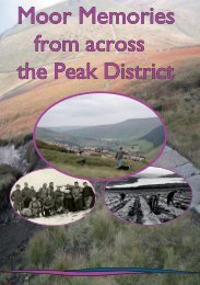
Recording form transect 1 - Moors for the Future
Recording form transect 1 - Moors for the Future
Recording form transect 1 - Moors for the Future

You also want an ePaper? Increase the reach of your titles
YUMPU automatically turns print PDFs into web optimized ePapers that Google loves.
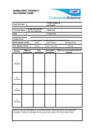
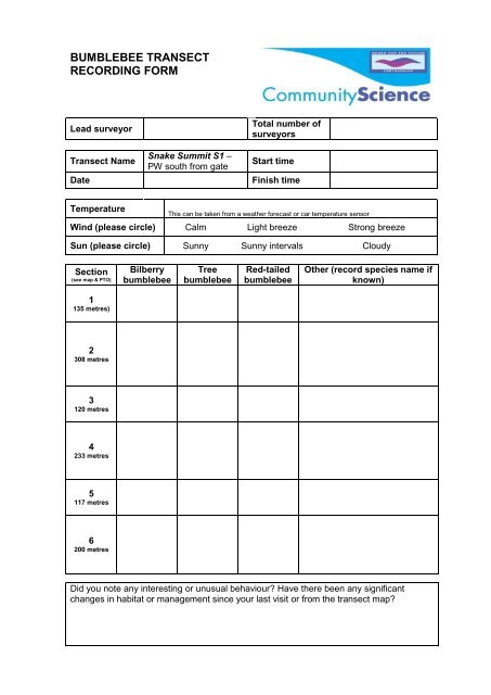
BUMBLEBEE TRANSECTRECORDING FORMLead surveyorTransect NameDateSnake Summit S1 –PW south from gateTotal number ofsurveyorsStart timeFinish timeTemperatureThis can be taken from a wea<strong>the</strong>r <strong>for</strong>ecast or car temperature sensorWind (please circle) Calm Light breeze Strong breezeSun (please circle) Sunny Sunny intervals CloudySection(see map & PTO)BilberrybumblebeeTreebumblebeeRed-tailedbumblebeeO<strong>the</strong>r (record species name ifknown)1135 metres)2308 metres3120 metres4233 metres5117 metres6200 metresDid you note any interesting or unusual behaviour? Have <strong>the</strong>re been any significantchanges in habitat or management since your last visit or from <strong>the</strong> <strong>transect</strong> map?
Don’t <strong>for</strong>get to enter your results as soon as possible atwww.moors<strong>for</strong><strong>the</strong>future.org.uk/community-scienceOr post this <strong><strong>for</strong>m</strong> to us (please see reverse <strong>for</strong> details).To submit your records by post, please complete <strong>the</strong> additional in<strong><strong>for</strong>m</strong>ation below andsend this <strong><strong>for</strong>m</strong> back to us at:Community Science Project Manager<strong>Moors</strong> <strong>for</strong> <strong>the</strong> <strong>Future</strong>The Moorland CentreEdaleDerbyshireS33 7ZAYour nameGroup or organisation youconducted <strong>the</strong> survey with (ifapplicable)AddressTelephone numberEmail addressWe will only contact you if we have any questions about your records.□ Please tick here if you are also happy <strong>for</strong> us to contact you with in<strong><strong>for</strong>m</strong>ation relating to<strong>the</strong> <strong>Moors</strong> <strong>for</strong> <strong>the</strong> <strong>Future</strong> Partnership’s Community Science Project.Transect DescriptionAccess to Start – The o<strong>the</strong>r side of <strong>the</strong> gate as <strong>the</strong> path heads south.Sections – <strong>the</strong>se describe where <strong>the</strong> sections change. Where possible, please use aGPS following <strong>the</strong> coordinates provided on <strong>the</strong> map.1 – begin at sign.1 to 2 – at <strong>the</strong> beginning of <strong>the</strong> path where it veers left/right/left in an S-shape2 to 3 – where a larger flagstone ‘bridges’ a water-course3 to 4 – where <strong>the</strong> path dips slightly and a larger flagstone ‘bridges’ a water-course4 to 5 – where a larger flagstone ‘bridges’ a water-course nad <strong>the</strong> path veers south-west5 to 6 - where <strong>the</strong> path dips slightly and a larger flagstone ‘bridges’ a water-courseEnd – finish at stake/beginning of S2.