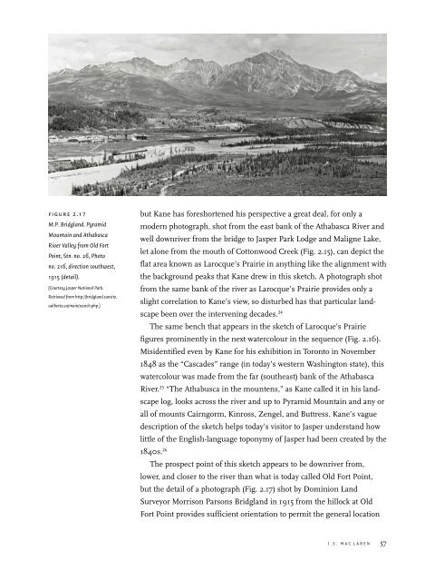
figure 2.17M.P. Bridgl<strong>and</strong>. PyramidMounta<strong>in</strong> <strong>and</strong> <strong>Athabasca</strong>River Valley from Old FortPo<strong>in</strong>t, Stn. no. 26, Photono. 216, direction southwest,1915 (detail).[Courtesy Jasper National Park.Retrieved from http://bridgl<strong>and</strong>.sunsite.ualberta.ca/ma<strong>in</strong>/search.php.]but Kane has foreshortened his perspective a great deal, for only amodern photograph, shot from <strong>the</strong> east bank of <strong>the</strong> <strong>Athabasca</strong> River <strong>and</strong>well downriver from <strong>the</strong> bridge to Jasper Park Lodge <strong>and</strong> Maligne Lake,let alone from <strong>the</strong> mouth of Cottonwood Creek (Fig. 2.15), can depict <strong>the</strong>flat area known as Larocque’s Prairie <strong>in</strong> anyth<strong>in</strong>g like <strong>the</strong> alignment with<strong>the</strong> background peaks that Kane drew <strong>in</strong> this sketch. A photograph shotfrom <strong>the</strong> same bank of <strong>the</strong> river as Larocque’s Prairie provides only aslight correlation to Kane’s view, so disturbed has that particular l<strong>and</strong>scapebeen over <strong>the</strong> <strong>in</strong>terven<strong>in</strong>g decades. 24The same bench that appears <strong>in</strong> <strong>the</strong> sketch of Larocque’s Prairiefigures prom<strong>in</strong>ently <strong>in</strong> <strong>the</strong> next watercolour <strong>in</strong> <strong>the</strong> sequence (Fig. 2.16).Misidentified even by Kane for his exhibition <strong>in</strong> Toronto <strong>in</strong> November1848 as <strong>the</strong> “Cascades” range (<strong>in</strong> today’s western Wash<strong>in</strong>gton state), thiswatercolour was made from <strong>the</strong> far (sou<strong>the</strong>ast) bank of <strong>the</strong> <strong>Athabasca</strong>River. 25 “The Athabusca <strong>in</strong> <strong>the</strong> mountens,” as Kane called it <strong>in</strong> his l<strong>and</strong>scapelog, looks across <strong>the</strong> river <strong>and</strong> up to Pyramid Mounta<strong>in</strong> <strong>and</strong> any orall of mounts Cairngorm, K<strong>in</strong>ross, Zengel, <strong>and</strong> Buttress. Kane’s vaguedescription of <strong>the</strong> sketch helps today’s visitor to Jasper underst<strong>and</strong> howlittle of <strong>the</strong> English-language toponymy of Jasper had been created by <strong>the</strong>1840s. 26The prospect po<strong>in</strong>t of this sketch appears to be downriver from,lower, <strong>and</strong> closer to <strong>the</strong> river than what is today called Old Fort Po<strong>in</strong>t,but <strong>the</strong> detail of a photograph (Fig. 2.17) shot by Dom<strong>in</strong>ion L<strong>and</strong>Surveyor Morrison Parsons Bridgl<strong>and</strong> <strong>in</strong> 1915 from <strong>the</strong> hillock at OldFort Po<strong>in</strong>t provides sufficient orientation to permit <strong>the</strong> general locationI . S . M a c L a r e n 57
of Kane’s sketch. The advantage of Bridgl<strong>and</strong>’s photograph over acontemporary one is that, although his did not precede <strong>the</strong> arrival of <strong>the</strong>two railways on <strong>the</strong> northwest bank of <strong>the</strong> <strong>Athabasca</strong>, only 60 yearsseparated it from <strong>the</strong> time of Kane’s sketch. Certa<strong>in</strong>ly, <strong>the</strong> two versionsresemble one ano<strong>the</strong>r <strong>in</strong> <strong>the</strong> general configuration of Pyramid Mounta<strong>in</strong>that <strong>the</strong>y depict. Kane has aga<strong>in</strong> lowered <strong>and</strong> foreshortened his perspective,with <strong>the</strong> result that <strong>the</strong> bench assumes a heightened prom<strong>in</strong>ence,but its orientation to Pyramid Mounta<strong>in</strong> is discernible <strong>in</strong> Bridgl<strong>and</strong>’sphotograph. For <strong>the</strong> purposes of comparison, however, a photographshot <strong>in</strong> October 2006 (Fig. 2.18) provides fur<strong>the</strong>r clarification of Kane’ssketch. The st<strong>and</strong>po<strong>in</strong>t for this photograph is an open flat on <strong>the</strong> rightside of <strong>and</strong> about halfway along <strong>the</strong> road lead<strong>in</strong>g from <strong>the</strong> bridge across<strong>the</strong> <strong>Athabasca</strong> River to Jasper Park Lodge. The flat sits up from <strong>the</strong> river,atop a steep, moderately high bank. Across <strong>the</strong> river <strong>and</strong> on <strong>the</strong> rightside of <strong>the</strong> photo, <strong>the</strong> draw, or gully, <strong>in</strong> <strong>the</strong> bench is located just a fewmetres from <strong>the</strong> railway rock-cut that lies just east of <strong>the</strong> turnoff fromHighway 16 to <strong>the</strong> bridge; <strong>the</strong> gully of Cottonwood Creek, <strong>and</strong> <strong>the</strong>turnoff from Highway 16 <strong>in</strong>to Jasper townsite, is less than one kilometrewest but too far away (to <strong>the</strong> left) to appear <strong>in</strong> <strong>the</strong> photograph. Meanwhile,<strong>the</strong> draw or gully to <strong>the</strong> left of centre <strong>in</strong> <strong>the</strong> photograph isunnamed <strong>and</strong> has no creek; Jasper cemetery is located where that gullyemerges from <strong>the</strong> bench. It appears to be <strong>the</strong> one that Kane features <strong>in</strong><strong>the</strong> centre of <strong>the</strong> middle ground of his sketch.The location of ano<strong>the</strong>r “sketch <strong>in</strong> <strong>the</strong> mountens” (Fig. 2.19) <strong>in</strong> <strong>the</strong><strong>Athabasca</strong> sequence rema<strong>in</strong>s to be determ<strong>in</strong>ed. It was thought <strong>in</strong>itiallyto resemble <strong>the</strong> view of Roche Ronde (north of <strong>and</strong> beh<strong>in</strong>d JasperHouse) from Rocky River, with <strong>the</strong> shoulder of Disaster Po<strong>in</strong>t <strong>and</strong>Syncl<strong>in</strong>e Ridge extend<strong>in</strong>g <strong>in</strong> from <strong>the</strong> right. However, <strong>the</strong> descent <strong>in</strong>towhat appears to be a nearly dry riverbed is too great to secure this identification.Moreover, <strong>the</strong> order suggested by Kane’s pencilled number—37—<strong>in</strong> <strong>the</strong> upper left corner suggests a location at least as far upriver asLarocque’s Prairie <strong>and</strong> today’s bridge. A likelier possibility is somewhereup <strong>the</strong> Whirlpool River valley, although <strong>in</strong>vestigations to date have notyielded a likely c<strong>and</strong>idate. The difficulty with any place very far up <strong>the</strong>Whirlpool is that <strong>the</strong> lower reaches of <strong>the</strong> l<strong>and</strong>scape <strong>in</strong> <strong>the</strong> picture planeappear <strong>in</strong>sufficiently snow-covered. After sketch<strong>in</strong>g number 36, presumablyon 7 November after camp<strong>in</strong>g at Larocque’s Prairie <strong>the</strong> previousnight, <strong>and</strong> <strong>the</strong>n proceed<strong>in</strong>g to Old Fort Po<strong>in</strong>t, Prairie de la Vache(Buffalo Prairie), past La Montagne de la Gr<strong>and</strong>e Traverse (Mount Edith58 <strong>Henry</strong> <strong>James</strong> Warre’s <strong>and</strong> <strong>Paul</strong> Kane’s <strong>Sketches</strong> <strong>in</strong> <strong>the</strong> <strong>Athabasca</strong> Watershed, 1846
- Page 1 and 2: 1 The University of Alberta PressEd
- Page 3 and 4: Published byThe University of Alber
- Page 5 and 6: 7 Laying the Tracks for Tourism 233
- Page 7 and 8: figure 2.1Henry James Warre, RockyM
- Page 9: figure 2.3Henry James Warre,Jasper
- Page 13 and 14: figure 2.7Paul Kane, Jasper’s Lak
- Page 15 and 16: figure 2.9Paul Kane, AthabascaRiver
- Page 17 and 18: Solomon Creek (downriver) and Fiddl
- Page 19 and 20: the order in which he made the sket
- Page 21: figure 2.15I.S. MacLaren. Athabasca
- Page 25 and 26: figure 2.20Paul Kane, Snow Scene in
- Page 27 and 28: figure 2.22I.S. MacLaren. Committee
- Page 29 and 30: Appendix 1Kane’s Field Notes, 30
- Page 31 and 32: Author’s NoteI thank Bob Hallam a
- Page 33 and 34: subject to Jasper House. (The entry
- Page 35 and 36: 28. George Simpson, Fur Trade and E
- Page 37 and 38: Royal Ontario Museum: 92 ETH, 42-50
- Page 39 and 40: Canadian Congress on Leisure Resear
- Page 41 and 42: ———. Report of the Panel on t
- Page 43 and 44: 2: 82-140. London: Samuel Curtis, 1
- Page 45 and 46: Hart, E.J. Diamond Hitch: The Early
- Page 47 and 48: ———. A History of Canada’s
- Page 49 and 50: Nelson, J.G., and R.C. Scace, eds.
- Page 51 and 52: Speares, Betty. “Mary, Mary, Quit