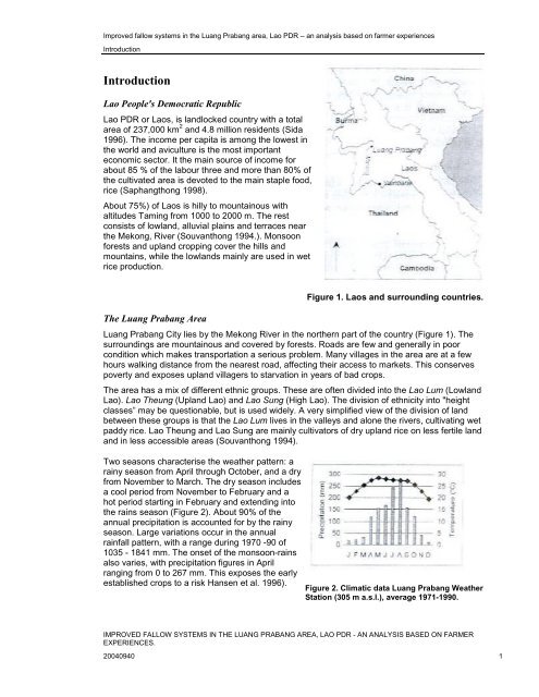
Improved <strong>fallow</strong> <strong>systems</strong> <strong>in</strong> <strong>the</strong> Luang Prabang <strong>area</strong>, Lao PDR – an analysis based on farmer experiencesIntroductionIntroductionLao People's Democratic RepublicLao PDR or Laos, is landlocked country with a total<strong>area</strong> of 237,000 km 2 and 4.8 million residents (Sida1996). The <strong>in</strong>come per capita is among <strong>the</strong> lowest <strong>in</strong><strong>the</strong> world and aviculture is <strong>the</strong> most importanteconomic sector. It <strong>the</strong> ma<strong>in</strong> source of <strong>in</strong>come forabout 85 % of <strong>the</strong> labour three and more than 80% of<strong>the</strong> cultivated <strong>area</strong> is devoted to <strong>the</strong> ma<strong>in</strong> staple food,rice (Saphangthong 1998).About 75%) of Laos is hilly to mounta<strong>in</strong>ous withaltitudes Tam<strong>in</strong>g from 1000 to 2000 m. The restconsists of lowland, alluvial pla<strong>in</strong>s and terraces near<strong>the</strong> Mekong, River (Souvanthong 1994.). Monsoonforests and upland cropp<strong>in</strong>g cover <strong>the</strong> hills andmounta<strong>in</strong>s, while <strong>the</strong> lowlands ma<strong>in</strong>ly are used <strong>in</strong> wetrice production.••The Luang Prabang AreaFigure 1. Laos and surround<strong>in</strong>g countries.Luang Prabang City lies by <strong>the</strong> Mekong River <strong>in</strong> <strong>the</strong> nor<strong>the</strong>rn part of <strong>the</strong> country (Figure 1). Thesurround<strong>in</strong>gs are mounta<strong>in</strong>ous and covered by forests. Roads are few and generally <strong>in</strong> poorcondition which makes transportation a serious problem. Many villages <strong>in</strong> <strong>the</strong> <strong>area</strong> are at a fewhours walk<strong>in</strong>g distance from <strong>the</strong> nearest road, affect<strong>in</strong>g <strong>the</strong>ir access to markets. This conservespoverty and exposes upland villagers to starvation <strong>in</strong> years of bad crops.The <strong>area</strong> has a mix of different ethnic groups. These are often divided <strong>in</strong>to <strong>the</strong> Lao Lum (LowlandLao). Lao Theung (Upland Lao) and Lao Sung (High Lao). The division of ethnicity <strong>in</strong>to "heightclasses” may be questionable, but is used widely. A very simplified view of <strong>the</strong> division of landbetween <strong>the</strong>se groups is that <strong>the</strong> Lao Lum lives <strong>in</strong> <strong>the</strong> valleys and alone <strong>the</strong> rivers, cultivat<strong>in</strong>g wetpaddy rice. Lao Theung and Lao Sung are ma<strong>in</strong>ly cultivators of dry upland rice on less fertile landand <strong>in</strong> less accessible <strong>area</strong>s (Souvanthong 1994).Two seasons characterise <strong>the</strong> wea<strong>the</strong>r pattern: ara<strong>in</strong>y season from April through October, and a dryfrom November to March. The dry season <strong>in</strong>cludesa cool period from November to February and ahot period start<strong>in</strong>g <strong>in</strong> February and extend<strong>in</strong>g <strong>in</strong>to<strong>the</strong> ra<strong>in</strong>s season (Figure 2). About 90% of <strong>the</strong>annual precipitation is accounted for by <strong>the</strong> ra<strong>in</strong>yseason. Large variations occur <strong>in</strong> <strong>the</strong> annualra<strong>in</strong>fall pattern, with a range dur<strong>in</strong>g 1970 -90 of1035 - 1841 mm. The onset of <strong>the</strong> monsoon-ra<strong>in</strong>salso varies, with precipitation figures <strong>in</strong> Aprilrang<strong>in</strong>g from 0 to 267 mm. This exposes <strong>the</strong> earlyestablished crops to a risk Hansen et al. 1996).Figure 2. Climatic data Luang Prabang Wea<strong>the</strong>rStation (305 m a.s.l.), average 1971-1990.IMPROVED FALLOW SYSTEMS IN THE LUANG PRABANG AREA, LAO PDR - AN ANALYSIS BASED ON FARMEREXPERIENCES.20040940 1
Improved <strong>fallow</strong> <strong>systems</strong> <strong>in</strong> <strong>the</strong> Luang Prabang <strong>area</strong>, Lao PDR – an analysis based on farmer experiencesIntroductionElevations vary <strong>in</strong> <strong>the</strong> study <strong>area</strong> from about 300 to 1400 m. The altitude range <strong>in</strong>duces differentclimatic conditions, which <strong>in</strong> turn affect soil properties, vegetation, crop suitability, etc. Hill slopestake up most of <strong>the</strong> <strong>area</strong> and soils found <strong>the</strong>re are ma<strong>in</strong>ly Haplic Alisols, and Dystric and FarallicCambisols. Common rock types are siltstone, sandstone, limestone, schist and phyllite. About 70percent of <strong>the</strong> cultivated upland <strong>area</strong>s are planted with upland rice. O<strong>the</strong>r crops <strong>in</strong>clude paddyrice, maize, sesame, Job's tear, beans, cotton, tobacco vegetables, etc. (Sodarak et al. 1997).Shift<strong>in</strong>g cultivationConceptsShift<strong>in</strong>g cultivation is quite undef<strong>in</strong>ed and is often called "slash-and-burn" or "swidden<strong>in</strong>g".Generally it consists of cutt<strong>in</strong>g <strong>the</strong> natural vegetation, leav<strong>in</strong>g it to dry and burn<strong>in</strong>g it for cropp<strong>in</strong>g<strong>the</strong> land. This is followed by a <strong>fallow</strong> period longer than <strong>the</strong> cropp<strong>in</strong>g phase (Chazee 1994).There are several types of shift<strong>in</strong>g cultivation and <strong>the</strong>re are many op<strong>in</strong>ions on how <strong>the</strong>y should bedef<strong>in</strong>ed. One quite simple view is that <strong>the</strong>re are two ma<strong>in</strong> types- pioneer<strong>in</strong>g- (or transitional-) androtational shift<strong>in</strong>g cultivation.Pioneer<strong>in</strong>g shift<strong>in</strong>g cultivation comprises land-less and small farmers who enter <strong>the</strong> forests often<strong>in</strong> <strong>the</strong> wake of forest harvest<strong>in</strong>g operations. They often lack <strong>the</strong> knowledge of susta<strong>in</strong>able use ofshift<strong>in</strong>g cultivation and upset <strong>the</strong> balance between people and land. This is a real problem for <strong>the</strong><strong>in</strong>dustry and threatens <strong>the</strong> environment (Sandewall et al. 1998).Rotational shift<strong>in</strong>g cultivation is based on short periods of cultivation alter<strong>in</strong>g with longer periodsof <strong>fallow</strong>, when natural vegetation will aga<strong>in</strong> cover <strong>the</strong> land. If <strong>the</strong> <strong>fallow</strong> is sufficiently long soilfertility is restored and potential weeds are repressed by forest re-growth. With <strong>fallow</strong> periods of 5to 15 years, shift<strong>in</strong>g cultivation can susta<strong>in</strong> repeated cycles of cropp<strong>in</strong>g (LSFP 1994). An exampleof <strong>the</strong> plot rotation <strong>in</strong> a very short, three-year cycle is presented <strong>in</strong> Figure 3.The rotational system, if well managed,allows a diversified production with steadypotential yields and virtually no soildegradation. The plant takes nutrientsfrom <strong>the</strong> soil m<strong>in</strong>eralised thanks toburn<strong>in</strong>g, and structured by <strong>the</strong> roots andbiological activities l<strong>in</strong>ked to <strong>the</strong> preced<strong>in</strong>gnatural vegetation. Yields are irregular,s<strong>in</strong>ce <strong>the</strong>y highly depend on climate andcrop pests (Chazee 1994).Year 1Year 2Year 3rice<strong>fallow</strong><strong>fallow</strong><strong>fallow</strong>rice<strong>fallow</strong><strong>fallow</strong><strong>fallow</strong>riceFigure 3. Rotational shift<strong>in</strong>g cultivation systemwith a three-year cycle.Shift<strong>in</strong>g cultivation <strong>in</strong> upland LaosShift<strong>in</strong>g cultivation is widely practised <strong>in</strong> <strong>the</strong> uplands of Laos, particularly <strong>in</strong> <strong>the</strong> nor<strong>the</strong>rn parts of<strong>the</strong> country. The traditional system typically consists of upland rice cropp<strong>in</strong>g for one year and<strong>the</strong>n a long <strong>fallow</strong> until <strong>the</strong> next use of <strong>the</strong> plot. However, <strong>the</strong> <strong>fallow</strong> periods are becom<strong>in</strong>g shorterwith an unsusta<strong>in</strong>able cropp<strong>in</strong>g system as a result.The shorten<strong>in</strong>g of <strong>fallow</strong> periods is caused by a number of factors. Government restrictions onshift<strong>in</strong>g cultivation and clear<strong>in</strong>g of older forest and a land allocation program force farmers toreduce <strong>the</strong> number of plots <strong>in</strong> <strong>the</strong> shift<strong>in</strong>g cultivation cycle. The tendency is streng<strong>the</strong>ned by aris<strong>in</strong>g population density through migration to <strong>area</strong>s with access to roads.IMPROVED FALLOW SYSTEMS IN THE LUANG PRABANG AREA, LAO PDR - AN ANALYSIS BASED ON FARMEREXPERIENCES.20040940 2