Storm Data and Unusual Weather Phenomena - CIG - Mesonet
Storm Data and Unusual Weather Phenomena - CIG - Mesonet
Storm Data and Unusual Weather Phenomena - CIG - Mesonet
- No tags were found...
You also want an ePaper? Increase the reach of your titles
YUMPU automatically turns print PDFs into web optimized ePapers that Google loves.
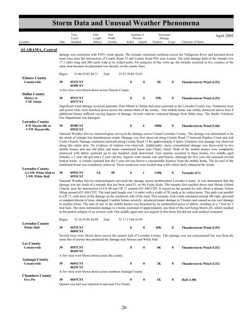
<strong>Storm</strong> <strong>Data</strong> <strong>and</strong> <strong>Unusual</strong> <strong>Weather</strong> <strong>Phenomena</strong>TimeLocal/PathLengthPathWidthNumber ofPersonsEstimatedDamageLocation Date St<strong>and</strong>ard (Miles) (Yards) Killed Injured Property Crops Character of <strong>Storm</strong>April 2005ALABAMA, Centraldamage was consistent with F0/F1 wind speeds. The tornado continued northeast across the Tallapoosa River <strong>and</strong> knocked downmore trees near the intersection of County Road 33 <strong>and</strong> County Road 828, near Louina. The total damage path of the tornado was17.1 miles long <strong>and</strong> 200 yards wide at its widest point. For purposes of this write-up, the tornado occurred in two counties at thesame time because its placement was directly on the county lines.Begin: 33 06.25/85 48.71 End: 33 07.39/85 33.03Elmore CountyCountywide 30 0522CST0548CST0 0 2K 0 Thunderstorm Wind (G52)A few trees were blown down across Elmore County.Dallas CountyMinter to 30 0531CST0 0 55K 0 Thunderstorm Wind (G55)5 SE Selma0557CSTSignificant wind damage occurred generally from Minter to Selma <strong>and</strong> areas eastward to the Lowndes County line. Numerous trees<strong>and</strong> power lines were knocked down across the eastern third of the county. One mobile home was totally destroyed <strong>and</strong> at least 8additional homes suffered varying degrees of damage. Several vehicles sustained damage from fallen trees. The Sardis VolunteerFire Department was damaged.Lowndes County8 W Hayneville to 30 0548CST0 4 100K 0 Thunderstorm Wind (G60)4 NW Hayneville0553CSTNational <strong>Weather</strong> Service meteorologists surveyed the damage across Central Lowndes County. The damage was determined to bethe result of straight line thunderstorm winds. Damage was first observed along County Road 17 between Panther Creek <strong>and</strong> AshCreek Church. Damage continued eastward along County Road 13 for approximately 4 miles. Extensive tree damage was observedalong this entire area. No evidence of rotation was observed. Additionally...more concentrated damage was discovered to twomobile homes <strong>and</strong> one old pillar <strong>and</strong> beam constructed home near Cherry Street. Both of the mobile homes were completelydestroyed with debris scattered up to one hundred yards downwind. Four injuries occurred in these homes, two middle agedfemales, a 2 year old girl <strong>and</strong> a 5 year old boy. Injuries were mostly cuts <strong>and</strong> bruises, although the five year old sustained severalbroken bones. A witness reported that the 5 year old was blown a considerable distance from the mobile home. The tin roof of thetraditional home was completely removed. These residences were located atop a hill which likely enhanced the winds.Lowndes County4.2 SW White Hall to 30 0552CST 1.6 50 0 1 110K 0 Tornado (F1)3 SW White Hall0553CSTNational <strong>Weather</strong> Service meteorologists surveyed the damage across northwestern Lowndes County. It was determined that thedamage was the result of a tornado that has been rated F1 on the Fujita Scale. The tornado first touched down near Mount GillardChurch, near the Intersection of US 80 <strong>and</strong> CR 17 around 652 AM CDT. It stayed on the ground for only about a minute, beforelifting around 653 AM CDT. The total path length was 1.6 miles with a width of 50 yards at its widest point. This path was parallelto CR 17, with most of the damage on the northwest side of the road. This tornado, with winds estimated around 100 mph, uprootedor snapped dozens of trees, damaged 2 mobile homes severely...produced minor damage to 3 homes <strong>and</strong> caused severe roof damageto another home. The side of one of the mobile homes was breached by an unidentified piece of debris, resulting in a 7 foot by 3foot hole. The most substantial damage to a home consisted of approximately one third of the roof being blown off, which resultedin the partial collapse of an exterior wall. One middle aged man was injured in this home but did not seek medical treatment.Begin: 32 16.51/86 44.88 End: 32 17.17/86 43.49Lowndes CountyWhite Hall 30 0553CST0 0 26K 0 Thunderstorm Wind (G55)0605CSTSeveral trees were blown down across the eastern half of Lowndes County. This damage was not concentrated but was from thesame line of storms that produced the damage near Mosses <strong>and</strong> White Hall.Lee CountyCountywide 30 0557CST0 0 4K 0 Thunderstorm Wind (G52)0645CSTA few trees were blown down across the county.Autauga CountyCountywide 30 0601CST0 0 2K 0 Thunderstorm Wind (G52)0625CSTA few trees were blown down across southern Autauga County.Chambers CountyFive Pts 30 0607CST0 0 1K 0 Hail (1.00)Quarter size hail was reported in <strong>and</strong> near Five Points.1620


