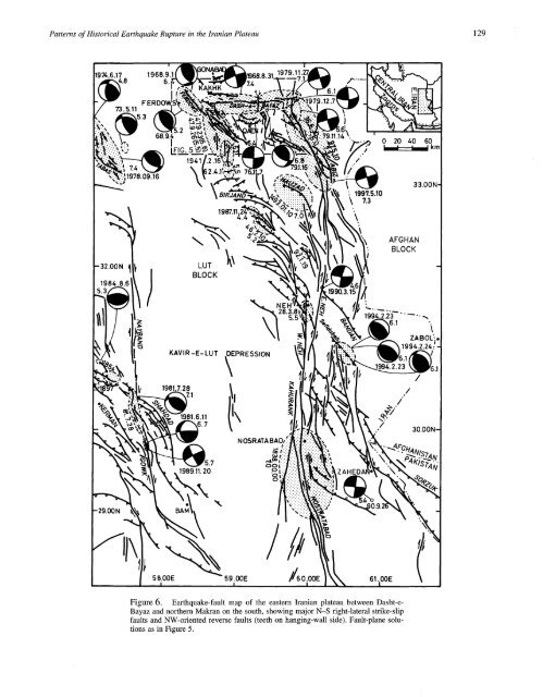
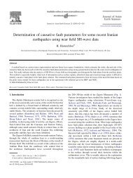
<strong>Patterns</strong> <strong>of</strong> <strong>Historical</strong> <strong>Earthquake</strong> <strong>Rupture</strong> <strong>in</strong> <strong>the</strong> <strong>Iranian</strong> <strong>Plateau</strong> 1291968.9.1~.8 6.£::68.9.~IFIG. 5"~’~194120 40 60I I Ikn1978.09.16 ’~¯ 199"/.5.10\¯33.004.4AFGHANBLOCK-32.00N1984.8.6LUTBLOCKKAVIR-E- LUT1981.7.287.1I~EPRESSIONNEH2.23 ..... ~6.1.~ZABOL;1994.2.24;.11981.6.117N OSRATA BAO,~:i1989.11.20OOP Z AH EDIO5 8.00E 59.00E //6 0.00E 61.00EFigure 6. <strong>Earthquake</strong>-fault map <strong>of</strong> <strong>the</strong> eastern <strong>Iranian</strong> plateau between Dasht-e-Bayaz and nor<strong>the</strong>rn Makran on <strong>the</strong> south, show<strong>in</strong>g major N-S fight-lateral strike-slipfaults and NW-oriented reverse faults (teeth on hang<strong>in</strong>g-wall side). Fault-plane solutionsas <strong>in</strong> Figure 5.
: 130 M. Berberian and R. S. Yeatsdows] used to be a large town but when I visited it was<strong>in</strong> ru<strong>in</strong>s..." (Nasser Khosrau, 1052 A.D.)The follow<strong>in</strong>g discussion focuses on <strong>the</strong> earthquake history<strong>of</strong> a region between <strong>the</strong> Dasht-e-Bayaz fault and <strong>the</strong>Nayband-Gowk fault to <strong>the</strong> west (Fig. 1). This prov<strong>in</strong>ceessentially <strong>the</strong> Shotori Range bounded on <strong>the</strong> west by <strong>the</strong>Tabas reverse fault, <strong>the</strong> Ferdows area to <strong>the</strong> east, and <strong>the</strong>broad depression <strong>in</strong> between (Figs. 1 and 6).The 1968 Dasht-e-Bayaz earthquake on a strike-slipfault was followed 20 h later by two large aftershocks(1968.09.01, s 6.4, a nd 1968.09.04, M5. 2) with re versefaultfocal mechanisms on <strong>the</strong> Ferdows reverse fault at <strong>the</strong>western end <strong>of</strong> <strong>the</strong> Dasht-e-Bayaz fault. The Ferdows earthquakescould be <strong>in</strong>terpreted as a separate ma<strong>in</strong>shock andaftershock, just as <strong>the</strong> 1992 Big Bear, California, left-lateralstrike-slip earthquake is considered as an event separatefrom <strong>the</strong> right-lateral strike-slip Landers earthquake to <strong>the</strong>east (Hauksson et al., 1993). The ma<strong>in</strong>shock on 1 Septemberwas 60 km west <strong>of</strong> <strong>the</strong> ma<strong>in</strong>shock <strong>of</strong> <strong>the</strong> Ms 7.4 Dasht-e-Bayaz earthquake.Ten years after <strong>the</strong> 1968 Dasht-e-Bayaz/Ferdows earthquakes,on 1978.09.16, <strong>the</strong> Tabas-e-Golshan earthquake <strong>of</strong>M s 7.4 ruptured <strong>the</strong> Tabas reverse fault at <strong>the</strong> western front<strong>of</strong> <strong>the</strong> Shotori Range. This earthquake was preceded by threesmall reverse-fault events <strong>in</strong> 1973 and 1974, but aside fromthose events, <strong>the</strong> Shotori Range had not been struck by alarge earthquake for at least 1100 yr. The eleventh-centuryMenar-e-Kabir Seljuk Tower, 40 m high, <strong>the</strong> EmamzadehHosse<strong>in</strong> structure built <strong>in</strong> 1057, and <strong>the</strong> twelfth-centuryMadreseh-ye-Dau Menar (Meshkati, 1970) rema<strong>in</strong>ed stand<strong>in</strong>guntil <strong>the</strong>y were destroyed dur<strong>in</strong>g <strong>the</strong> 1978 earthquake(Fig. 6; Berberian, 1979, 1982).The Tabas-e-Golshan earthquake was accompanied bysurface rupture along <strong>the</strong> entire Shotori range-front fault,with surface rupture correspond<strong>in</strong>g reasonably well with <strong>the</strong>length <strong>of</strong> <strong>the</strong> ma<strong>in</strong>shock subsurface rupture. In contrast, <strong>the</strong>smaller Ferdows earthquakes <strong>of</strong> 1968 ruptured only <strong>the</strong>northwestern third <strong>of</strong> <strong>the</strong> Ferdows reverse fault system,based on aftershock distribution. The Ferdows earthquakeswere part <strong>of</strong> ano<strong>the</strong>r sequence that began <strong>in</strong> 1941 with anearthquake <strong>of</strong> M s 6.1, followed by a larger earthquake <strong>of</strong> Ms6.8 <strong>in</strong> 1947 (Figs. 5 and 6). It is not clear, however, thatei<strong>the</strong>r <strong>of</strong> <strong>the</strong>se events occurred on <strong>the</strong> Ferdows reverse-faultsystem. The 1941 meizoseismal zone is elongated parallelto a north-south-trend<strong>in</strong>g fight-lateral strike-slip fault. The1947 meizoseismal zone also has more <strong>of</strong> a north-south orientationthan <strong>the</strong> NW-SE strike <strong>of</strong> <strong>the</strong> Ferdows reverse-faultsystem, which extends sou<strong>the</strong>ast beyond <strong>the</strong> 1947 meizoseismalzone. Local people reported a ground fracture strik<strong>in</strong>gNW-SE along <strong>the</strong> Ferdows fault, between Badamuk andGurab (B and G along <strong>the</strong> Ferdows fault <strong>in</strong> Fig. 5), fordistance <strong>of</strong> at least 6 km with <strong>the</strong> nor<strong>the</strong>astern hang<strong>in</strong>g-wallblock uplifted (Ambraseys and Melville, 1977, 1982). Thus,<strong>the</strong> 1947 event appears to have ruptured part <strong>of</strong> <strong>the</strong> Ferdowsfault system, but o<strong>the</strong>r faults may have been <strong>in</strong>volved aswell. The tim<strong>in</strong>g and overlap <strong>of</strong> meizoseismal zones <strong>in</strong>dicatean earthquake sequence progress<strong>in</strong>g to <strong>the</strong> northwest.The Tabas and Ferdows earthquakes are examples <strong>of</strong>cross-strike pairs <strong>of</strong> reverse-fault earthquakes, <strong>in</strong> which onefollows <strong>the</strong> o<strong>the</strong>r <strong>in</strong> a time span <strong>of</strong> decades. O<strong>the</strong>r examplesare <strong>the</strong> 1929 Murchison and 1968 Inangahua earthquakes <strong>in</strong>northwest Nelson, New Zealand, <strong>the</strong> 1971 Sylmar and 1994Northridge earthquakes <strong>in</strong> <strong>the</strong> San Fernando Valley, California,and <strong>the</strong> 1944 San Juan and 1977 Caucete earthquakes<strong>in</strong> <strong>the</strong> Pampean Ranges <strong>of</strong> northwest Argent<strong>in</strong>a. All <strong>the</strong>seexamples occurred <strong>in</strong> thick-sk<strong>in</strong>ned range-and-bas<strong>in</strong> prov<strong>in</strong>ces(Yeats et al., 1997). As discussed earlier, two additionalexamples may be <strong>the</strong> 1209 and 1389 B<strong>in</strong>alud earthquakesand <strong>the</strong> 1270 and 1405 Neyshabur earthquakes <strong>in</strong>nor<strong>the</strong>astern Iran, although that region has not been shownto be characterized by thick-sk<strong>in</strong>ned deformation.Tabriz"The Sorkhab Mounta<strong>in</strong> [<strong>in</strong> north Tabriz] was faultedby deep fissures <strong>of</strong> 2 zars [-2 meters] wide and 2 farsangs[--12 km] long trend<strong>in</strong>g sou<strong>the</strong>ast [along <strong>the</strong>North Tabriz fault]..." (Donboli, 1813 A.D., describ<strong>in</strong>g<strong>the</strong> 1780 Tabriz earthquake).The Tabriz region is located <strong>in</strong> <strong>the</strong> Araxes structuralblock <strong>of</strong> northwestern Iran, southwest <strong>of</strong> <strong>the</strong> cont<strong>in</strong>uation <strong>of</strong><strong>the</strong> western Alborz Mounta<strong>in</strong>s toward <strong>the</strong> Caucasus. TheNorth Tabriz fault (NTF) is a complex northwest-trend<strong>in</strong>gstructure that conta<strong>in</strong>s evidence <strong>of</strong> fight-lateral strike-slipdisplacement observed on aerial photographs, and verticaldisplacement with <strong>the</strong> north side up (Fig. 7; Berberian andArshadi, 1976; Berberian, 1997; Berberian and Qorashi,1987, 1999b). The NTF merges northwest with a zone <strong>of</strong>reverse faults that turns to <strong>the</strong> west-southwest <strong>in</strong> <strong>the</strong> areanorth <strong>of</strong> Lake Urumiyeh (Sufian and Tasuj faults; Fig. 7),and it merges sou<strong>the</strong>ast with ano<strong>the</strong>r zone <strong>of</strong> reverse faults,which turns to <strong>the</strong> east-nor<strong>the</strong>ast (South and North Bozqush,Duzduzan, and South Sarab faults; Fig. 8).The NTF system and adjacent reverse faults rupturedfrom sou<strong>the</strong>ast to northwest <strong>in</strong> three earthquakes <strong>in</strong> 65 yr:<strong>the</strong> Shebli earthquake (M-- 7.3) <strong>in</strong> 1721 on <strong>the</strong> sou<strong>the</strong>asternNTF with a surface rupture >35 km long as reported byBrydges (1834); <strong>the</strong> Tabriz earthquake (M-- 7.4) <strong>in</strong>on <strong>the</strong> northwestern NTF, with surface rupture >42 km longand 2- to 4-m vertical separation as reported by al-Omari(1795), Zonuzi (1801), Donboli (1813), and Drouville(1825); and <strong>the</strong> Marand-Mishu earthquake (M -- 6.3)1786 on <strong>the</strong> Mishu reverse fault and <strong>the</strong> Sufian segment <strong>of</strong><strong>the</strong> NTF. A fourth earthquake <strong>of</strong> M -- 5.5 struck <strong>the</strong> Tasujreverse fault far<strong>the</strong>r west <strong>in</strong> 1807. A fifth earthquake <strong>of</strong> M-- 6.7 took place along <strong>the</strong> South Bozqush reverse fault far<strong>the</strong>rsou<strong>the</strong>ast <strong>in</strong> 1879 (Fig. 8; see discussion later). Theearthquake segment boundaries correspond to geometric discont<strong>in</strong>uitiessuch as stepovers (overlaps, <strong>of</strong>fsets) and abruptchanges <strong>in</strong> strike. The boundary between <strong>the</strong> Tabriz and