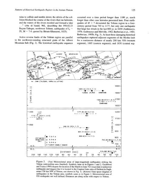
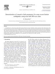
<strong>Patterns</strong> <strong>of</strong> <strong>Historical</strong> <strong>Earthquake</strong> <strong>Rupture</strong> <strong>in</strong> <strong>the</strong> <strong>Iranian</strong> <strong>Plateau</strong> 125ta<strong>in</strong>s to collide and tumble down; <strong>the</strong> debris <strong>of</strong> <strong>the</strong> collisionblocked <strong>the</strong> course <strong>of</strong> <strong>the</strong> rivers that ran between,and <strong>the</strong> waters <strong>of</strong> <strong>the</strong> rivers receded and formed a lake..." (ebn al-’Amid, 961, describ<strong>in</strong>g <strong>the</strong> 958.02.23Ruyan-Taleqan, northwest Tehran, earthquake <strong>of</strong> Io --IX, M -- 7.4; quoted by Biruni-Kharazmi, 1025).Active reverse faults <strong>of</strong> <strong>the</strong> Tehran region are parallelto <strong>the</strong> northwest-trend<strong>in</strong>g structural gra<strong>in</strong> <strong>of</strong> <strong>the</strong> AlborzMounta<strong>in</strong> belt (Fig. 3). The historical earthquake sequenceoccurred over a time period longer than 1100 yr, muchlonger than o<strong>the</strong>r case histories presented here. Four earthquakes<strong>of</strong> M > 7 devastated <strong>the</strong> Tehran region <strong>in</strong> a fourcenturyperiod from 743 to 1177, but only one earthquakethat large has struck <strong>in</strong> <strong>the</strong> last 800 yr, <strong>in</strong> 1830 (Ambraseys,1970; Ambraseys and Melville, 1982; Berberian et al., 1985;Berberian, 1995b; Fig. 3). At least three damag<strong>in</strong>g historicalearthquakes ruptured adjacent segments <strong>of</strong> <strong>the</strong> Mosha faultfor a cont<strong>in</strong>uous distance <strong>of</strong> nearly 200 km: 958 (westernsegment), 1665 (eastern segment), and 1830 (central1830.03.27( IX.7.1 )-- ----I----I~------TEHRAN JAJRUD DAMAVAND1900-1800-- 1 200 1177--1119.12.10(Vl I I ,6.5)QAZV I N1177.05.00(IX,7.2)RAY1665.06-07 (V I I, 6.5) 1700?--~). ?DAMAVAND1600-1200-- I 000A.D.MAGNITUDE 6.0-6.9(Ms)958.02.23(X,7.7)S. 0-5.90 ? QUEST I ONABLE DAMAGERAY864.01-02(Vl I ,5.3)~ RAYB.C. --~[DISTANCE (km)]200 180 140 120 100 80 60 40 20 0 20L i t 1 l l l l__l__l__l"-" 1100-1000-~ 900 -743.03-06(~111+,7.2)800 -TSD 700 -A.D...,’312--280 BC(Xg;6)?40[60 80 100L~Figure 3. (Top) Meizoseismal areas <strong>of</strong> large-magnitude earthquakes strik<strong>in</strong>g <strong>the</strong>Tehran metropolitan area (hatched). Symbols same as <strong>in</strong> Figures 1 and 2. Guidoboniand Tra<strong>in</strong>a (1995) dispute <strong>the</strong> location <strong>of</strong> <strong>the</strong> March to June 743 (exact date is unknown)earthquake and suggest that it is located <strong>in</strong> <strong>the</strong> Caspian Gates area <strong>of</strong> Derbent <strong>in</strong> Daghestan(750 km NW <strong>of</strong> Tehran, not shown <strong>in</strong> Fig. 1). (Bottom) Time-space diagram <strong>of</strong>earthquakes <strong>in</strong> <strong>the</strong> Tehran area; symbols same as <strong>in</strong> Figure 2. Meizoseismal area <strong>of</strong>958 earthquake not well def<strong>in</strong>ed. Distances are along strike with respect to Tehran.
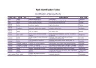
126 M. Berberian and R. S. Yeatsment, north <strong>of</strong> Tehran; Berberian et al., 1985). The Moshafault has a youthful scarp. The boundary between <strong>the</strong> 958and 1830 ruptures is marked by an abrupt change <strong>in</strong> faultstrike, but <strong>the</strong> boundary between <strong>the</strong> 1830 and 1665 rupturesis not marked by an obvious geological discont<strong>in</strong>uity. Thecont<strong>in</strong>uation <strong>of</strong> <strong>the</strong> Mosha fault east <strong>of</strong> <strong>the</strong> 1665 rupture hasnot ruptured historically <strong>in</strong> a large earthquake (Fig. 3; Berberianet al., 1985).We are unable to assign <strong>the</strong> 855 to 856 (exact year uncerta<strong>in</strong>)and 1177 earthquakes to specific faults. These earthquakescould have ruptured <strong>the</strong> North Tehran thrust (NTT),which marks <strong>the</strong> range front at <strong>the</strong> north edge <strong>of</strong> <strong>the</strong> Tehranpla<strong>in</strong> (Fig. 4). In contrast to <strong>the</strong> Mosha fault, however, <strong>the</strong>NTT has a less dist<strong>in</strong>ctive fault scarp. An additional complicationis <strong>the</strong> presence <strong>of</strong> south-dipp<strong>in</strong>g reverse faults, <strong>in</strong>part bl<strong>in</strong>d, such as <strong>the</strong> Bagh-e-Feyz, Davudieh, T.V., Mahmudieh,Shian, and o<strong>the</strong>r faults <strong>in</strong> <strong>the</strong> Tehran pla<strong>in</strong> (Fig. 4).South-dipp<strong>in</strong>g reverse faults may account for uplift <strong>of</strong> <strong>the</strong>NTT footwall block, analogous to <strong>the</strong> 1994 Northridge earthquakeon a bl<strong>in</strong>d thrust that uplifted <strong>the</strong> footwall <strong>of</strong> <strong>the</strong> SantaSusana fault (Yeats and Huftile, 1995). If this is <strong>the</strong> case,<strong>the</strong> south-dipp<strong>in</strong>g faults could have produced <strong>the</strong> 855 to 856and <strong>the</strong> 1177 events. If such an earthquake occurred today,it would wreak a catastrophe on <strong>the</strong> Tehran metropolitanregion. A complicat<strong>in</strong>g factor is <strong>the</strong> poor documentation <strong>of</strong><strong>the</strong> location <strong>of</strong> <strong>the</strong> 855 to 856 earthquake, which could be<strong>the</strong> mislocated Kumes earthquake (M-- 7.4 + ) <strong>of</strong> 856.12.22<strong>in</strong> <strong>the</strong> Damghan region (located <strong>in</strong> Fig. 1). These eventscould also have been located along <strong>the</strong> Ray-Kahrizak faultsystem south <strong>of</strong> Tehran (Figs. 1 and 3). The Qazv<strong>in</strong> earthquake(M-- 6.5) <strong>of</strong> 1119.12.10 on <strong>the</strong> North Qazv<strong>in</strong> thrustto <strong>the</strong> west may be a cont<strong>in</strong>uation <strong>of</strong> <strong>the</strong> zone <strong>of</strong> large earthquakeson <strong>the</strong> Mosha fault but separated from <strong>the</strong> surfacetrace <strong>of</strong> that fault by a historical gap (Fig. 3).Dasht-e-Bayaz/Abiz FaultsThe first two study regions are part <strong>of</strong> <strong>the</strong> reversefaultedranges that extend across nor<strong>the</strong>rn Iran, <strong>in</strong>clud<strong>in</strong>g <strong>the</strong>Alborz Range (Fig. 1). To <strong>the</strong> sou<strong>the</strong>ast, across <strong>the</strong> centralKavir depression, <strong>the</strong> structural style changes dramatically~ulti0 0 0 0TehronFigure 4. Map <strong>of</strong> Tehran metropolitan areas <strong>of</strong> 1970 (diagonal dashed l<strong>in</strong>es) show<strong>in</strong>gNorth Tehran thrust, smaller faults, and partly covered faults (numbered by a letterfollowed by a number), some range fac<strong>in</strong>g with<strong>in</strong> <strong>the</strong> Tehran pla<strong>in</strong>. Contour <strong>in</strong>tervals<strong>in</strong> 200 m. Open circles <strong>in</strong>dicate anomalies <strong>in</strong> groundwater elevation (dropp<strong>in</strong>g to <strong>the</strong>south). Long and short broken l<strong>in</strong>es are <strong>the</strong> exist<strong>in</strong>g highways and roads, respectively,<strong>in</strong> Tehran.