Patterns of Historical Earthquake Rupture in the Iranian Plateau
Patterns of Historical Earthquake Rupture in the Iranian Plateau
Patterns of Historical Earthquake Rupture in the Iranian Plateau
- No tags were found...

You also want an ePaper? Increase the reach of your titles
YUMPU automatically turns print PDFs into web optimized ePapers that Google loves.
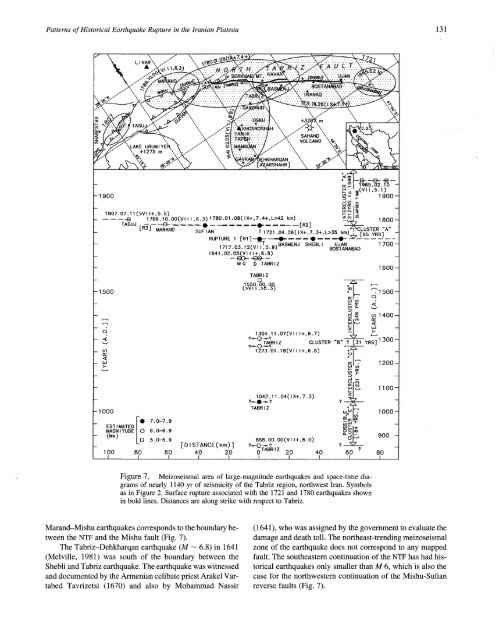
<strong>Patterns</strong> <strong>of</strong> <strong>Historical</strong> <strong>Earthquake</strong> <strong>Rupture</strong> <strong>in</strong> <strong>the</strong> <strong>Iranian</strong> <strong>Plateau</strong> 131^~.~-/,,// \LAKE URU~.~ ~,_+1275o.-- E~ 1965.02.10 -~ (v~,~.~)- 1 900 N ~ ~ 900 -- E~I~ -1807.07.1 I(>Vl 1+,5.5)- -~ ~786.~o.oo(v~ ,6.~) ~7~O.O~.08(~X+,7.~+,L>~2T"F~ R ~A ~.=) ~ ~800-_ -- 1500M G D TABRIZTABR I ZRUPTURE 1 [R1]~~~~~~ -:~-- 1717.03.12(VI IT5.9) BASMENJ, SHEBL I BOSTANABADUJAN1700-1641.02.05(VI I 1+,6.8)1600-1550 O00Q r-~(>V~ r,>5". 3)~ 1 500 -1304.11 .07(VI I 1+,6.7) ----’J7~-~~ u~ 1 400 -~ -?~0~? ~ ~1300TABRIZ CLUSTER "B" ? [31 YRS] -?~01273.01 .18(Vl I 1+,6.5)~0T¯ 1200--- 1000_ FO 7.0--7.9EST I MATEDMAGN I TUDE 6.0-6 9- (Ms)5.0-5 9--100 80 60[DISTANCE(km)]40 201042.11 .04( I X+,7.3) z.L.TABR I Z,,=,1.", 11 oo-~,°1’ 1000-~’858.oo.oo(vl ~+,6.0)"°._L.~900?~o ~ ?oTABRIZ 20J J40l60 "180Figure 7. Meizoseismal area <strong>of</strong> large-magnitude earthquakes and space-time diagrams<strong>of</strong> nearly 1140 yr <strong>of</strong> seismicity <strong>of</strong> <strong>the</strong> Tabriz region, northwest Iran. Symbolsas <strong>in</strong> Figure 2. Surface rupture associated with <strong>the</strong> 1721 and 1780 earthquakes shown<strong>in</strong> bold l<strong>in</strong>es. Distances are along strike with respect to Tabriz.Marand-Mishu earthquakes corresponds to <strong>the</strong> boundary between<strong>the</strong> NTF and <strong>the</strong> Mishu fault (Fig. 7).The Tabriz-Dehkharqan earthquake (M-- 6.8) <strong>in</strong> 1641(Melville, 1981) was south <strong>of</strong> <strong>the</strong> boundary between <strong>the</strong>Shebli and Tabriz earthquake. The earthquake was witnessedand documented by <strong>the</strong> Armenian celibate priest Arakel VartabedTavrizetsi (1670) and also by Mohammad Nassir(1641), who was assigned by <strong>the</strong> government to evaluate <strong>the</strong>damage and death toll. The nor<strong>the</strong>ast-trend<strong>in</strong>g meizoseismalzone <strong>of</strong> <strong>the</strong> earthquake does not correspond to any mappedfault. The sou<strong>the</strong>astern cont<strong>in</strong>uation <strong>of</strong> <strong>the</strong> NTF has had historicalearthquakes only smaller than M 6, which is also <strong>the</strong>case for <strong>the</strong> northwestern cont<strong>in</strong>uation <strong>of</strong> <strong>the</strong> Mishu-Sufianreverse faults (Fig. 7).