Umrer Coalfield - Western Coalfields Limited
Umrer Coalfield - Western Coalfields Limited
Umrer Coalfield - Western Coalfields Limited

Create successful ePaper yourself
Turn your PDF publications into a flip-book with our unique Google optimized e-Paper software.
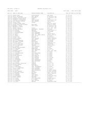
CMPDITable 2.1 Electromagnetic spectral regionsRegion Wavelength RemarksGamma ray < 0.03 nm Incoming radiation is completely absorbed by theupper atmosphere and is not available for remotesensing.X-ray 0.03 to 3.00 nm Completely absorbed by atmosphere. Notemployed in remote sensing.Ultraviolet 0.03 to 0.40 µm Incoming wavelengths less than 0.3mm arecompletely absorbed by Ozone in the upperatmosphere.Photographic UVband0.30 to 0.40 µm Transmitted through atmosphere. Detectable withfilm and photo detectors, but atmosphericscattering is severe.Visible 0.40 to 0.70 µm Imaged with film and photo detectors. Includesreflected energy peak of earth at 0.5mm.Infrared 0.70 to 100.00 µm Interaction with matter varies with wavelength.Absorption bands separate atmospherictransmission windows.Reflected IR band 0.70 to 3.00 µm Reflected solar radiation that contains noinformation about thermal properties of materials.The band from 0.7-0.9mm is detectable with filmand is called the photographic IR band.Thermal IR band 3.008.00toto5.00 µm14.00 µmPrincipal atmospheric windows in the thermalregion. Images at these wavelengths areacquired by optical-mechanical scanners andspecial vediocon systems but not by film.Microwave 0.10 to 30.00 cm Longer wavelengths can penetrate clouds, fogand rain. Images may be acquired in the active orpassive mode.Radar 0.10 to 30.00 cm Active form of microwave remote sensing. Radarimages are acquired at various wavelengthbands.Radio > 30.00 cm Longest wavelength portion of electromagneticspectrum. Some classified radars with very longwavelength operate in this region.The earth's atmosphere absorbs energy in the gamma-ray, X-ray and most of theultraviolet (UV) region; therefore, these regions are not used for remote sensing.Details of these regions are shown in Figure 2.3. The horizontal axes showwavelength on a logarithmic scale; the vertical axes show percent atmospherictransmission of EM energy. Wavelength regions with high transmission are calledatmospheric windows and are used to acquire remote sensing data. Detectionand measurement of the recorded energy enables identification of surface objects(by their characteristic wavelength patterns or spectral signatures), bothfrom air-borne and space-borne platforms.RSC-561410027(WCL) [ Page 11 of 32]
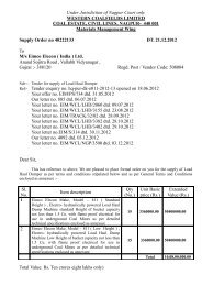
![To [Name & Address of the Assured] Dear Mr./Ms.[______] Subject ...](https://img.yumpu.com/48378713/1/190x245/to-name-address-of-the-assured-dear-mr-ms-subject-.jpg?quality=85)