Umrer Coalfield - Western Coalfields Limited
Umrer Coalfield - Western Coalfields Limited
Umrer Coalfield - Western Coalfields Limited

Create successful ePaper yourself
Turn your PDF publications into a flip-book with our unique Google optimized e-Paper software.
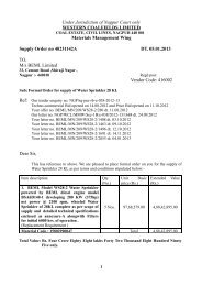
CMPDITable 3.3 Block wise Area Statistics -<strong>Umrer</strong> CF(2011)Classes Area in km 2Level-I Level-II Makardhokra I Makardhokra IIMakardhokra MineExtn. I + III <strong>Umrer</strong> SouthUrban Settlements 0.00 0.08 0.00 0.32Rural Settlements 0.00 0.00 0.08 0.24SettlementsIndustrial Settlements 0.01 0.13 0.00 0.10Dense Forest 0.00 0.00 0.00 0.00Open Forest 0.00 0.35 0.00 0.04Scrubs 0.89 0.85 1.62 1.50Plantation on OB Dump 0.05 0.05 0.00 0.00Plantation on Backfill 0.05 0.61 0.00 0.19Vegetation Cover Social Forestry 0.00 0.03 0.00 0.24Crop land 1.61 0.53 7.47 1.16AgricultureFallow Land 3.24 0.75 8.76 2.21Waste Land 0.59 0.18 0.57 0.49Waste LandSand Body 0.00 0.00 0.00 0.00Coal Quarry 0.49 0.02 0.00 0.91Advance Quarry Site 0.00 0.00 0.00 0.06Mining AreaBarren OB Dump 0.10 0.17 0.00 0.03Barren Backfill 0.53 1.06 0.00 1.05Coal Dump 0.01 0.19 0.00 0.03Water Filled Quarry 0.05 0.00 0.00 0.06Water Body River/ Ponds 0.17 0.17 0.22 0.327.79 5.16 18.71 8.97RSC-561410027(WCL) [Page 28 of 32 ]
![To [Name & Address of the Assured] Dear Mr./Ms.[______] Subject ...](https://img.yumpu.com/48378713/1/190x245/to-name-address-of-the-assured-dear-mr-ms-subject-.jpg?quality=85)