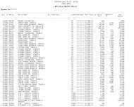
Umrer Coalfield - Western Coalfields Limited
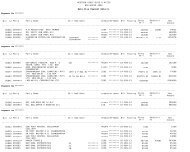
Umrer Coalfield - Western Coalfields Limited
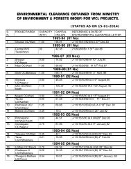
Umrer Coalfield - Western Coalfields Limited

Create successful ePaper yourself
Turn your PDF publications into a flip-book with our unique Google optimized e-Paper software.
CMPDILand Use/ Cover MappingChapter 33.1 IntroductionLand is one of the most important natural resource on which all human activities arebased. Therefore, knowledge on different type of lands as well as its spatialdistribution in the form of map and statistical data is vital for its geospatial planningand management for optimal use of the land resources. In mining industry, the needfor information on land use/ vegetation cover pattern has gained importance due tothe all-round concern on environmental impact of mining. The information on landuse/ cover inventory that includes type, spatial distribution, aerial extent, location,rate and pattern of change of each category is of paramount importance forassessing the impact of coal mining on land use/ vegetation cover.Remote sensing data with its various spectral and spatial resolutions offercomprehensive and accurate information for mapping and monitoring of landuse/cover pattern, dynamics of changing pattern and trends over a period of time.By analysing the data of different cut-off dates, impact of coal mining on land useand vegetation cover can be determined.3.2 Land Use/Cover ClassificationThe array of information available on land use/cover requires arrangement orgrouping under a suitable framework in order to facilitate the creation of a landuse/cover database. Further, to accommodate the changing land use/cover pattern,it becomes essential to develop a standardised classification system that is not onlyRSC-561410027(WCL) [ Page 22 of 32 ]
![To [Name & Address of the Assured] Dear Mr./Ms.[______] Subject ...](https://img.yumpu.com/48378713/1/190x245/to-name-address-of-the-assured-dear-mr-ms-subject-.jpg?quality=85)