

The optimum offshore survey workflow for high-quality GIS ... - Caris
The optimum offshore survey workflow for high-quality GIS ... - Caris
The optimum offshore survey workflow for high-quality GIS ... - Caris
- No tags were found...

You also want an ePaper? Increase the reach of your titles
YUMPU automatically turns print PDFs into web optimized ePapers that Google loves.
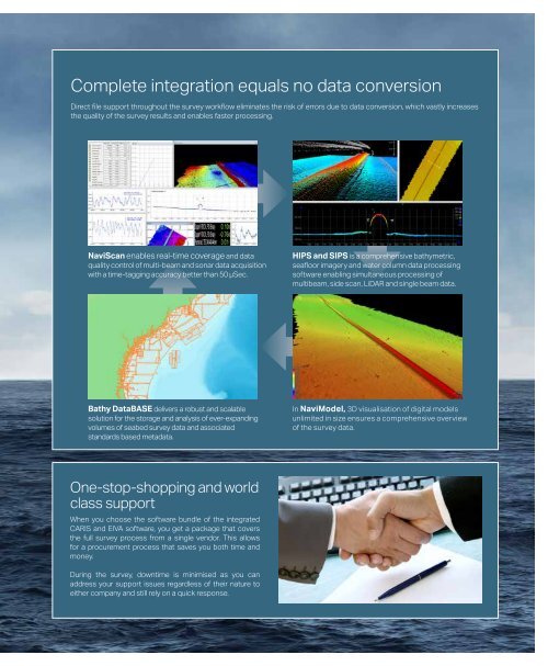
Complete integration equals no data conversionDirect file support throughout the <strong>survey</strong> <strong>workflow</strong> eliminates the risk of errors due to data conversion, which vastly increasesthe <strong>quality</strong> of the <strong>survey</strong> results and enables faster processing.NaviScan enables real-time coverage and data<strong>quality</strong> control of multi-beam and sonar data acquisitionwith a time-tagging accuracy better than 50 µSec.HIPS and SIPS is a comprehensive bathymetric,seafloor imagery and water column data processingsoftware enabling simultaneous processing ofmultibeam, side scan, LiDAR and single beam data.Bathy DataBASE delivers a robust and scalablesolution <strong>for</strong> the storage and analysis of ever-expandingvolumes of seabed <strong>survey</strong> data and associatedstandards based metadata.In NaviModel, 3D visualisation of digital modelsunlimited in size ensures a comprehensive overviewof the <strong>survey</strong> data.One-stop-shopping and worldclass supportWhen you choose the software bundle of the integratedCARIS and EIVA software, you get a package that coversthe full <strong>survey</strong> process from a single vendor. This allows<strong>for</strong> a procurement process that saves you both time andmoney.During the <strong>survey</strong>, downtime is minimised as you canaddress your support issues regardless of their nature toeither company and still rely on a quick response.


