

The optimum offshore survey workflow for high-quality GIS ... - Caris
The optimum offshore survey workflow for high-quality GIS ... - Caris
The optimum offshore survey workflow for high-quality GIS ... - Caris
- No tags were found...

You also want an ePaper? Increase the reach of your titles
YUMPU automatically turns print PDFs into web optimized ePapers that Google loves.
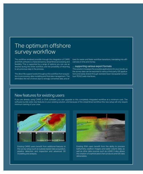
<strong>The</strong> <strong>optimum</strong> <strong>offshore</strong><strong>survey</strong> <strong>workflow</strong><strong>The</strong> <strong>workflow</strong> rendered possible through the integration of CARISand EIVA software is characterised by streamlined processing andflexibility. This is supported by a range of options you can use asdesired during the entire <strong>workflow</strong>, and the possibility of returningto any previous step in the process.<strong>The</strong> direct file support exists throughout the <strong>workflow</strong> from acquisitionto processing, data modelling and final data management. Thiseliminates the risk of errors due to wrongly converted data, and allows<strong>for</strong> easier and faster <strong>workflow</strong> transitions, translating into efficienciesin time and money.… supporting various export <strong>for</strong>matsThis solution increases the possible applications <strong>for</strong> your results, asthe <strong>survey</strong> data can be exported to various third-party <strong>GIS</strong> applicationsand easily shared through standard Open Geospatial Consortium®(OGC) web interfaces.New features <strong>for</strong> existing usersIf you are already using CARIS or EIVA software, you can upgrade to this completely integrated <strong>workflow</strong> at a minimum cost. <strong>The</strong>software bundle adds new features to your existing solution, and because of the streamlined <strong>workflow</strong> this new setup will only requireminimum training of your crew.Courtesy of Statoil and DOF SubseaExisting CARIS users benefit from additional features tothe <strong>survey</strong> setup such as subsea-based data acquisition,pipeline detection and inspection and advanced 3Dmodelling and analysis.Existing EIVA users benefit from the ability to processbathymetry, seafloor imagery and water column data, aswell as other data sources such as LiDAR. It also allowsthe creation of sophisticated chart products and <strong>GIS</strong> datadeliverables.


