

Meghalaya - Ministry of Environment and Forests
Meghalaya - Ministry of Environment and Forests
Meghalaya - Ministry of Environment and Forests

Create successful ePaper yourself
Turn your PDF publications into a flip-book with our unique Google optimized e-Paper software.
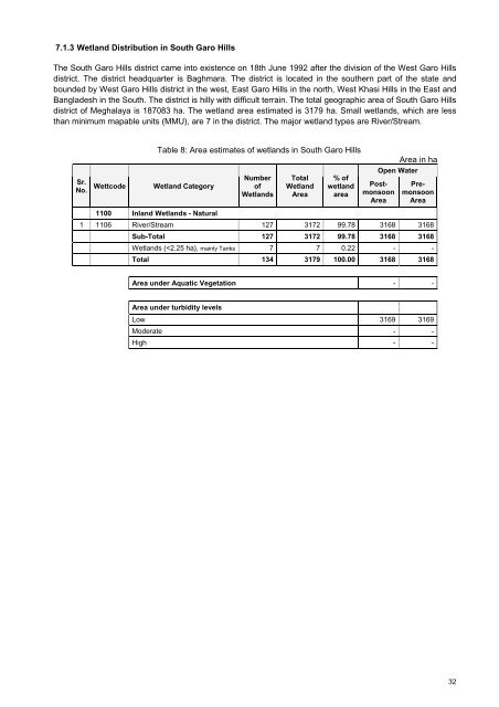
7.1.3 Wetl<strong>and</strong> Distribution in South Garo HillsThe South Garo Hills district came into existence on 18th June 1992 after the division <strong>of</strong> the West Garo Hillsdistrict. The district headquarter is Baghmara. The district is located in the southern part <strong>of</strong> the state <strong>and</strong>bounded by West Garo Hills district in the west, East Garo Hills in the north, West Khasi Hills in the East <strong>and</strong>Bangladesh in the South. The district is hilly with difficult terrain. The total geographic area <strong>of</strong> South Garo Hillsdistrict <strong>of</strong> <strong>Meghalaya</strong> is 187083 ha. The wetl<strong>and</strong> area estimated is 3179 ha. Small wetl<strong>and</strong>s, which are lessthan minimum mapable units (MMU), are 7 in the district. The major wetl<strong>and</strong> types are River/Stream.Sr.No.WettcodeTable 8: Area estimates <strong>of</strong> wetl<strong>and</strong>s in South Garo HillsWetl<strong>and</strong> CategoryNumber<strong>of</strong>Wetl<strong>and</strong>sTotalWetl<strong>and</strong>Area% <strong>of</strong>wetl<strong>and</strong>areaOpen WaterPostmonsoonAreaArea in haPremonsoonArea1100 Inl<strong>and</strong> Wetl<strong>and</strong>s - Natural1 1106 River/Stream 127 3172 99.78 3168 3168Sub-Total 127 3172 99.78 3168 3168Wetl<strong>and</strong>s (


