

Meghalaya - Ministry of Environment and Forests
Meghalaya - Ministry of Environment and Forests
Meghalaya - Ministry of Environment and Forests

Create successful ePaper yourself
Turn your PDF publications into a flip-book with our unique Google optimized e-Paper software.
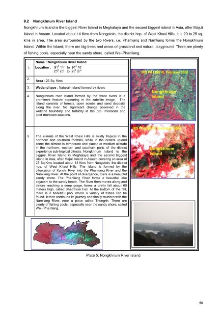
9.2 Nongkhnum River Isl<strong>and</strong>Nongkhnum Isl<strong>and</strong> is the biggest River Isl<strong>and</strong> in <strong>Meghalaya</strong> <strong>and</strong> the second biggest isl<strong>and</strong> in Asia, after MajuliIsl<strong>and</strong> in Assam. Located about 14 Kms from Nongstoin, the district hqs. <strong>of</strong> West Khasi Hills, it is 20 to 25 sq.kms in area. The area surrounded by the two Rivers, i.e. Phanliang <strong>and</strong> Namliang forms the NongkhnumIsl<strong>and</strong>. Within the Isl<strong>and</strong>, there are big trees <strong>and</strong> areas <strong>of</strong> grassl<strong>and</strong> <strong>and</strong> natural playground. There are plenty<strong>of</strong> fishing pools, especially near the s<strong>and</strong>y shore, called Wei-Phanliang.1.2.3.4.Name : Nongkhnum River Isl<strong>and</strong>Location : 91 0 14’ to 91 0 16’25 0 25’ to 25 0 27’Area : 25 Sq. KmsWetl<strong>and</strong> type : Natural- Isl<strong>and</strong> formed by riversNongkhnum river isl<strong>and</strong> formed by the three rivers is aprominent feature appearing in the satellite image. TheIsl<strong>and</strong> consists <strong>of</strong> forests, open scrubs <strong>and</strong> s<strong>and</strong> depositsalong the river. No significant change observed in thewetl<strong>and</strong> boundary <strong>and</strong> turbidity in the pre- monsoon <strong>and</strong>post-monsoon seasons.IRS P6 LISS III, February 2006NongkhnumIsl<strong>and</strong>5.The climate <strong>of</strong> the West Khasi Hills is mildly tropical in thenorthern <strong>and</strong> southern foothills, while in the central upl<strong>and</strong>zone; the climate is temperate <strong>and</strong> places at medium altitudein the northern, western <strong>and</strong> southern parts <strong>of</strong> the districtexperience sub-tropical climate. Nongkhnum Isl<strong>and</strong> is thebiggest River Isl<strong>and</strong> in <strong>Meghalaya</strong> <strong>and</strong> the second biggestisl<strong>and</strong> in Asia, after Majuli Isl<strong>and</strong> in Assam covering an area <strong>of</strong>25 Sq.Kms located about 14 Kms from Nongstoin, the districthqs. <strong>of</strong> West Khasi Hills. The Isl<strong>and</strong> is formed by thebifurcation <strong>of</strong> Kynshi River into the Phanliang River <strong>and</strong> theNamliang River. At the point <strong>of</strong> divergence, there is a beautifuls<strong>and</strong>y shore. The Phanliang River forms a beautiful lakeadjacent to the s<strong>and</strong>y beach. The River then moves along <strong>and</strong>before reaching a deep gorge, forms a pretty fall about 60meters high, called Shadthum Fall. At the bottom <strong>of</strong> the fall,there is a beautiful pool where a variety <strong>of</strong> fishes can befound. It then continues its journey <strong>and</strong> finally reunites with theNamliang River, near a place called Thongrin. There areplenty <strong>of</strong> fishing pools, especially near the s<strong>and</strong>y shore, calledWei- Phanliang.IRS P6 LISS III, December 2006NongkhnumIsl<strong>and</strong>Plate 5: Nongkhnum River Isl<strong>and</strong>66


