Division of Land Into Large Parcels Tentative Map ... - Elko County
Division of Land Into Large Parcels Tentative Map ... - Elko County
Division of Land Into Large Parcels Tentative Map ... - Elko County
- No tags were found...

Create successful ePaper yourself
Turn your PDF publications into a flip-book with our unique Google optimized e-Paper software.
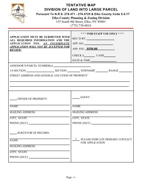
TENTATIVE MAPDIVISION OF LAND INTO LARGE PARCELPursuant To N.R.S. 278.471 - 278.4725 & <strong>Elko</strong> <strong>County</strong> Code 5-2-17<strong>Elko</strong> <strong>County</strong> Planning & Zoning <strong>Division</strong>155 South 9th Street, <strong>Elko</strong>, NV 89801(775) 738-6816APPLICATION MUST BE SUBMITTED WITHALL REQUIRED INFORMATION AND THEAPPLICATION FEE. AN INCOMPLETEAPPLICATION WILL NOT BE ACCEPTED FORREVIEW.* * * FOR STAFF USE ONLY * * *REC’D BY:APP. NO:APP. FEE: $550.00CHECK #DATE & TIMECASHASSESSOR’S PARCEL NUMBER(s)1/4 SECTION SECTION TOWNSHIP RANGESTREET ADDRESS AND GENERAL LOCATION OF PROPERTYOWNER OF PROPERTY:NAMEMAILING ADDRESSCITY, STATEPHONE (DAY):AGENT:NAMEMAILING ADDRESSCITY, STATEPHONE (DAY):SURVEYOR OF RECORD:NAMEMAILING ADDRESS* PLEASE INDICATE PRIMARY CONTACTFOR APPLICATIONCITY, STATEPHONE (DAY):Page -1-
TENTATIVE MAP DIVISION OF LAND INTO LARGE PARCELAPPLICATION SUBMITTAL REQUIREMENTS:THE FOLLOWING ITEMS MUST BE COMPLETED AND SUBMITTED WITH THIS APPLICATION.INCOMPLETE APPLICATIONS WILL NOT BE ACCEPTED.FOR STAFF USE ONLYAPPLICATION FORM COMPLETED, WITH NOTARIZED SIGNATURE OF OWNER ORAUTHORIZED AGENT.LEGAL DESCRIPTION OF PROPERTY. METES AND BOUNDS OR ALIQUOT PART(S),AND A COPY OF ANY REFERENCED AND FILED (RECORDED) MAP.VERIFICATION OF OWNERSHIP COPY OF MOST RECENTLY RECORDED DEEDREFLECTING THE CURRENT OWNERSHIP.WILL SERVE LETTERS (If applicable) WATER, SEWER, SOLID WASTE, AND ANYOTHER PUBLIC UTILITIES.OFFICIAL WRITTEN COMMENTS FROM AGENCIES WHICH HAVE REVIEWED THETENTATIVE MAP. (I.E. - STATE AGENCIES, ACTIVE ARCHITECTURAL REVIEWCOMMITTEE, ETC..)VICINITY MAP, TOPOGRAPHY MAP, AND FLOOD ZONE MAP (IF PRINTED)ZONING VERIFICATION OF EXISTING ZONINGSUPPLEMENTAL DATA FORM THIS SHOULD BE ATTACHED.TEN FOLDED COPIES OF THE PROPOSED TENTATIVE MAP, COMPLETE WITH:OWNER’S SIGNATURE AND PROFESSIONAL LAND SURVEYORS’S SIGNATUREAND STAMP.Page -2-
THE TENTATIVE MAP DIVISION OF LAND INTO LARGE PARCELMUST SHOW THE FOLLOWING:1. ALL ADJACENT PROPERTY OWNERS AND HOLDINGS OF OWNER.2. DOCUMENTED LEGAL RIGHT-OF-WAY TO EXISTING AND PROPOSED NEWPARCELS.3. LOCATION, NAME AND RIGHT-OF-WAY WIDTHS OF ALL ADJOININGSTREETS OR ACCESS EASEMENTS.4. PROPOSED NAME OF EACH NEW STREET AND TYPICAL SECTION OF STREETIMPROVEMENTS (WHEN REQUIRED), ALONG WITH CURVE RADIUS ANDGRADES OF ALL PERIMETER AND PROPOSED STREETS OR ACCESSEASEMENTS.5. WIDTH, LOCATION AND PURPOSE FOR ALL EXISTING AND PROPOSEDEASEMENTS - FOR ACCESS, DRAINAGE IRRIGATION, UTILITIES, ETC.6. IDENTIFICATION OF ALL PARCELS BY LETTER OR NUMBER. THEDIMENSIONS AND NET ACREAGE FOR EACH PARCEL SHALL BE CLEARLYSHOWN.7. VICINITY MAP, LEGEND, NORTH ARROW AND SCALE (ALSO SHEET NO.S IFMORE THAN ONE)8. BASIS OF BEARINGS CLEARLY SHOWN.9. OWNER’S CERTIFICATE WITH NOTARY PUBLIC CERTIFICATE.10. PREPARING SURVEYOR’S CERTIFICATE.11. DELINEATION OF ANY SPECIAL FLOOD HAZARD AREAS, AND THEACCOMPANYING NOTE CONCERNING COMPLIANCE WITH THE COUNTY’SFLOOD PREVENTION CODES FOR ANY NEW/FUTURE CONSTRUCTION.NOTE: ADDITIONAL INFORMATION MAY BE REQUIRED OR REQUESTED BY THE COUNTYSURVEYOR, ENGINEER, PLANNING COMMISSION, OR COUNTY COMMISSIONERS.Page -3-
OWNER'S AFFIDAVITAPPLICATION AGREEMENTI, UNDERSIGNED OWNER ( OR AUTHORIZED AGENT, WITH A LETTER OF APPROVAL FROMTHE PROPERTY OWNER) OF THE PROPERTY HEREIN DESCRIBED, HEREBY MAKEAPPLICATION FOR THE COMMUNITY DEVELOPMENT DEPARTMENT’S REVIEW OF THETENTATIVE MAP BEING SUBMITTED, AND I HEREBY CERTIFY THAT THE INFORMATIONGIVEN IS TRUE AND CORRECT TO THE BEST OF MY KNOWLEDGE. IN ADDITION, IUNDERSTAND THAT THIS APPLICATION MUST BE DETERMINED TO BE COMPLETE BYCOUNTY STAFF AND WILL NOT BE ACCEPTED FOR COMPLETE REVIEW UNTIL SUCHDETERMINATION HAS BEEN MADE.THE APPLICATION HEREBY SUBMITTED TRULY REPRESENTS MY INTENDED PROPOSAL.THEREFORE I UNDERSTAND AND AGREE THAT MY APPLICATION WILL PROCEED FORPROPER REVIEW PROCEDURES, UNLESS A SUBSTANTIAL CHANGE ( AS DETERMINED BYSTAFF) IS MADE DURING THE PUBLIC NOTICE PERIOD.I HEREBY CERTIFY THAT I HAVE READ AND UNDERSTAND THIS APPLICATION.SIGNATURESUBSCRIBED AND SWORN TO BEFORE ME THIS DAY OF , 20 .(NOTARY PUBLIC)COUNTY OF(SEAL), STATE OF NEVADAPage -4-
TENTATIVE MAPDIVISION OF LAND INTO LARGE PARCELApplication Data FormELKO COUNTY HAS WITHIN ITS ADOPTED CODES, ZONING ORDINANCE AND OTHER DEVELOPMENTCRITERIA. VARIOUS REQUIREMENTS, PROVISIONS, INTENDED PURPOSES, SPECIFICATIONS, FEES,VIOLATIONS, AND PENALTIES ARE SET FORTH THEREIN.If you have questions or need assistance please contactPlanning, Zoning, Building & Safety <strong>Division</strong>(775) 738-6816 or 738-2266, Extension No. 3, 4 or 6155 South 9th Street, <strong>Elko</strong>, NV 89801Provide the following information, mandatory for all applications requiring public review and hearings.Answer the following questions thoroughly. Please provide all pertinent and significant Informationuse additional pages as necessary.I. PROJECT DESCRIPTION:Project or Applicant Name:Total size <strong>of</strong> property and Total No. Of Proposed <strong>Parcels</strong>Reason for subdividing land?Will Road Right <strong>of</strong> Ways be <strong>of</strong>fered for dedication for public purposes? ____________________If No Explain Alternative_________________________________________________________________________________________________________________________________________________________________________________________________________________Will Applicant request Alternate Compliance for any applicable Code? _____________________If Yes explain_______________________________________________________________________________________________________________________________________________Additional Information :Page -5-
II. SPECIAL DEVELOPMENT INFORMATION:PLEASE BE AWARE THAT IF YOU MAKE ANY INACCURATE STATEMENTS FILLING OUT THIS SUPPLEMENTALINFORMATION FORM COULD DELAY ACTION ON THIS PARCEL MAP APPLICATION.If YES is answered to ANY <strong>of</strong> the following questions please provide an explanation on aseparate page.DIVISION OF LAND INTO LARGE PARCELS DEVELOPMENT YES NO1. Development, construction or grading on steep slopes.2. Will require extensive earth work or grading.3. Development or construction on fill or expansive soils.4. Will be altering the course <strong>of</strong> any drainage or waterway.5. Will cause an increase in: ash, dust, smoke, fumes or odor to the area or surroundingproperties.6. Proposed project is located on lands that periodically flood or is totally or partially within aflood zone. If yes, provide Flood Zone Designation.7. Will cause the loss <strong>of</strong> wetland or waterway vegetation.8. Will create the reduction <strong>of</strong> agricultural lands, crop lands or agricultural soils.9. Will require the removal <strong>of</strong> trees or large amounts <strong>of</strong> brush.10. Will cause an increase in noise or vibration on or <strong>of</strong>f-site.11. Is substantially different in size or character from existing development patterns <strong>of</strong> the area.12. A notice <strong>of</strong> violation or citation has been issued concerning this property or project.13. Will create a substantial increase in energy / resource use.14. Will cause a loss <strong>of</strong> existing housing units.15. Will cause an increase in housing units.16. Will substantially increase vehicular traffic to the area.17. Involve the use <strong>of</strong>: a) toxic or hazardous materials, b) highly flammable materials, c)explosives.18. Will introduce the risk <strong>of</strong> an explosion or the release <strong>of</strong> hazardous substances in the event<strong>of</strong> an accident.19. Will expose public to untreated or partially treated sewage or chemical pollution.20. Will require outdoor areas illuminated at night21. Will change the scenic view from existing: a) residentialareas, b) public lands, c) roadways.22. Will involve possible archaeological or historical significant areas.Page -6-
DIVISION OF LAND INTO LARGE PARCELS DEVELOPMENT YES NO23. Will involve development on more than one parcel <strong>of</strong> land.24. This project is part <strong>of</strong> a speculated or proposed series <strong>of</strong> future projects.25. This project is located within one (1) mile <strong>of</strong> the Incorporated City limits <strong>of</strong> the City <strong>of</strong>.26. If so has the City Council, Planning Commission or Staff been notified <strong>of</strong> this proposal?27. Are the Incorporated City comments attached to this application?28. This project is located within the un-incorporated town or community <strong>of</strong>.29. If so has the town or community advisory board has been notified <strong>of</strong> this proposal.30. Are the un-incorporated town or community comments attached to this application?31. There are known written or verbal subdivision (CC&R’s) (DOR’s) restrictions attached tothis property. If yes attach a current copy to this application.32. This application has been submitted to the applicable architectural review committee, ifrequired.32a. If yes, then attach a copy <strong>of</strong> letter <strong>of</strong> approval to this application.33. The applicant/developer has contacted adjacent property owners about the possibleammendment <strong>of</strong> this property.34. The applicant/developer is aware <strong>of</strong> any prior <strong>Elko</strong> <strong>County</strong> Planning Commission or <strong>Elko</strong><strong>County</strong> Commissions actions against the development <strong>of</strong> this property.35. Will the proposed require NDEP and/or Army Corp pf Engineers action or permitting?36.There is currently a lawsuit pending that will impact this property. If yes, please provide thecase number and names <strong>of</strong> the parties involved in the lawsuit.37. There is currently a lawsuit pending on properties adjacent to this property that will impactaccess or have other impacts upon this property. If yes, please provide the case number andnames <strong>of</strong> the parties involved in the lawsuit.38. DOES THIS LAND CURRENTLY MEET THE AGRICULTURAL LANDCLASSIFICATION AND IS “AGRICULTURALLY DEFERRED” FOR TAXPURPOSES?39. IS THIS LAND MORE THAN 40 ACRES IN SIZE?40. IS THIS LAND CURRENTLY BEING USED FOR AGRICULTURAL PURPOSES?41. DESCRIBE THE LANDS ON ALL FOUR (4) SIDES OF THIS PROPERTY, INCLUDING USES.( USE ANOTHER SHEET OF PAPER IF NEEDED)41.Page -7-
42. If a second or subsequent subdivision is proposed, when was this property first subdivided, by whom and date<strong>of</strong> the zone change and/or subdivision application?43. <strong>Elko</strong> <strong>County</strong> Recorders File Number?Page -8-