Landscape Evolution at an Active Plate Margin - Biological Science ...
Landscape Evolution at an Active Plate Margin - Biological Science ...
Landscape Evolution at an Active Plate Margin - Biological Science ...

Create successful ePaper yourself
Turn your PDF publications into a flip-book with our unique Google optimized e-Paper software.
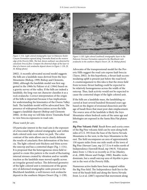
Figure 1-15A. Light colored str<strong>at</strong>igraphic layer in Paleozoic Keeler<br />
C<strong>an</strong>yon Form<strong>at</strong>ion exposed along Tinemaha Road on the western<br />
edge of the Poverty Hills. The bed, shown outlined, was distorted by<br />
c<strong>at</strong>aclastic breccia flow. Compare the distorted shape of the layer to<br />
th<strong>at</strong> of a known rock aval<strong>an</strong>che deposit shown in Figure 1-15b. [K.<br />
M. Bishop photo]<br />
2002). A recently advoc<strong>at</strong>ed second model suggests<br />
the hills are a l<strong>an</strong>dslide mass derived from the Inyo<br />
Mountains (Bishop, 1999; Bishop <strong>an</strong>d Clements,<br />
2006), although the l<strong>an</strong>dslide model was first suggested<br />
in the 1960s by Pakiser et al. (1964) based on<br />
a gravity survey of the valley. If the hills are indeed a<br />
l<strong>an</strong>dslide, the long-run out character classifies it as a<br />
rock aval<strong>an</strong>che. Correct interpret<strong>at</strong>ion of the origin<br />
of the hills is import<strong>an</strong>t because it has implic<strong>at</strong>ions<br />
for underst<strong>an</strong>ding the kinem<strong>at</strong>ics of the Owens Valley<br />
fault. The l<strong>an</strong>dslide model will be advoc<strong>at</strong>ed here. The<br />
presence of widespread brecci<strong>at</strong>ion across the hills<br />
suggest a l<strong>an</strong>dslide deposit (Bishop <strong>an</strong>d Clements<br />
2006). At this stop we will hike down Tinemaha Road<br />
to view breccia exposures in road cuts.<br />
Please w<strong>at</strong>ch for cars.<br />
Of particular interest in the road cuts is the exposure<br />
of a brecci<strong>at</strong>ed light-colored str<strong>at</strong>igraphic unit within<br />
dark colored units near where we park. The color<br />
contrast of the units allows one to clearly deline<strong>at</strong>e<br />
the results of c<strong>at</strong>aclastic flow deform<strong>at</strong>ion of the breccia.<br />
The light-colored unit thickens <strong>an</strong>d thins across<br />
the outcrop <strong>an</strong>d has a contorted shape (Fig. 1-15A).<br />
It is proposed th<strong>at</strong> the heterogeneous stress field required<br />
to cre<strong>at</strong>e this p<strong>at</strong>tern is the result of fluctu<strong>at</strong>ing<br />
internal stresses cre<strong>at</strong>ed by vibr<strong>at</strong>ion <strong>an</strong>d/or variable<br />
traction as the l<strong>an</strong>dslide mass moved rapidly across<br />
<strong>an</strong> irregular ground surface. The deformed geometry<br />
of the light-colored unit is reminiscent of the geometry<br />
of deformed str<strong>at</strong>igraphic units present in the<br />
Blackhawk l<strong>an</strong>dslide, a well-known rock aval<strong>an</strong>che<br />
deposit in the southern Mojave Desert (Fig. 1-15B).<br />
D. R. Jessey <strong>an</strong>d R. E. Reynolds<br />
Figure 1-15B. Light colored (outlined) str<strong>at</strong>igraphic layer in the<br />
Paleozoic Furnace Form<strong>at</strong>ion exposed in the Blackhawk rock<br />
aval<strong>an</strong>che in the southern Mojave Desert. [K. M. Bishop photo]<br />
Advoc<strong>at</strong>es of the tr<strong>an</strong>spressional model for the Poverty<br />
Hills suggest the road cuts expose fault breccia<br />
(Tayor, 2002). In this hypothesis, a thrust fault accommod<strong>at</strong>ing<br />
uplift is present just below the road level.<br />
A counterargument to this idea is th<strong>at</strong> the stress field<br />
from tectonic thrust faulting could be expected to<br />
be rel<strong>at</strong>ively homogeneous across the width of the<br />
outcrop. Thus, fault activity would not be expected to<br />
cause the contorted shape of the light-colored unit.<br />
If the hills are a l<strong>an</strong>dslide mass, the l<strong>an</strong>dsliding occurred<br />
<strong>at</strong> least several hundred thous<strong>an</strong>d years ago<br />
based on the degree of erosional dissection <strong>an</strong>d the<br />
age of basalt flows th<strong>at</strong> must post-d<strong>at</strong>e emplacement.<br />
The source area of the l<strong>an</strong>dslide is likely the Inyo<br />
Mountains where bedrock units of the same age <strong>an</strong>d<br />
lithologies are exposed in the S<strong>an</strong>ta Rita Fl<strong>at</strong> pluton<br />
area.<br />
Big Pine Volc<strong>an</strong>ic Field. Basalt flows <strong>an</strong>d scoria cones<br />
of the Big Pine volc<strong>an</strong>ic field c<strong>an</strong> be seen along both<br />
sides of U.S. 395 from the base of the Sierra Nevada<br />
Mountains to the west, to the Inyo Mountains to the<br />
east. The field encompasses <strong>an</strong> area of approxim<strong>at</strong>ely<br />
150 square miles from one mile south of the town of<br />
Big Pine (Stewart L<strong>an</strong>e, mp 217.5) to 8 miles north of<br />
Independence (Sawmill Road, mp 196.9). Volc<strong>an</strong>ism<br />
d<strong>at</strong>es from 1.2 Ma to as recently as 25 ka (M<strong>an</strong>ley,<br />
et al., 2000; Moore <strong>an</strong>d Dodge, 1980). Basaltic rocks<br />
domin<strong>at</strong>e, but a small outcrop area of rhyolite is present<br />
to the west of the Poverty Hills.<br />
Numerous active faults have been mapped within<br />
the Big Pine field. The Independence fault lies to the<br />
west of the basalt field <strong>an</strong>d along the Sierra Nevada<br />
front. Le et al. (2007) reported th<strong>at</strong> movement along<br />
24 2009 Desert Symposium