Landscape Evolution at an Active Plate Margin - Biological Science ...
Landscape Evolution at an Active Plate Margin - Biological Science ...
Landscape Evolution at an Active Plate Margin - Biological Science ...

You also want an ePaper? Increase the reach of your titles
YUMPU automatically turns print PDFs into web optimized ePapers that Google loves.
Table 3-1. Mineral assemblages <strong>at</strong> Reward <strong>an</strong>d Brown Monster<br />
Reward Mine Brown Monster Mine<br />
Anglesite Conichalcite Linarite<br />
Arsentsumebite Copper Malachite Calcite<br />
Azurite Corkite Mimetite Galena<br />
Beud<strong>an</strong>tite Cuprite Perite Linarite<br />
Broch<strong>an</strong>tite Duftite Pyrargyrite Mimetite<br />
Calcite Fornacite Pyrite Quartz<br />
Caledonite Galena Pyromorphite<br />
Cerussite Goethite Quartz<br />
‘Chalcedony’ Gold Schmiederite<br />
Chalcopyrite Hedyph<strong>an</strong>e Tsumebite<br />
Chlorargyrite Hemimorphite V<strong>an</strong>adinite<br />
Chrysocolla Leadhillite Wulfenite<br />
(Mind<strong>at</strong>.org, 2009; Pemberton, 1983)<br />
52.6 (2.7) Prepare for a left turn. W<strong>at</strong>ch for oncoming<br />
traffic. The M<strong>an</strong>z<strong>an</strong>ar Reloc<strong>at</strong>ion Center c<strong>an</strong> be seen<br />
to the south.<br />
52.8 (0.2) TURN LEFT (east) onto M<strong>an</strong>z<strong>an</strong>ar/Reward<br />
Road. This road leads to the Union Mining District<br />
near the base of the Inyo Mountains where gold was<br />
discovered in the 1860s (Knopf, 1918). Chief producers<br />
were the Brown Monster <strong>an</strong>d Reward mines (Fig.<br />
3-4) with gold production estim<strong>at</strong>ed between 10,000<br />
<strong>an</strong>d 50,000 ounces. The country rock consists of<br />
Paleozoic shale, limestone, <strong>an</strong>d conglomer<strong>at</strong>e, as well<br />
as Jurassic-Triassic shale, tuff, <strong>an</strong>d volc<strong>an</strong>ic breccia.<br />
These rocks were intruded by Mesozoic gr<strong>an</strong>itoids<br />
gener<strong>at</strong>ing lode vein deposits near the contact with<br />
the intrusions. Near-surface ore is highly oxidized<br />
consisting mainly of quartz <strong>an</strong>d minor amounts of<br />
limonite, smithsonite, broch<strong>an</strong>tite, linarite, chrysocolla,<br />
<strong>an</strong>d wulfenite. Unoxidized ore consists of quartz<br />
with small amounts of pyrite, galena, sphalerite, <strong>an</strong>d<br />
chalcopyrite.<br />
53.1 (0.3) Cross M<strong>an</strong>z<strong>an</strong>ar l<strong>an</strong>ding strip.<br />
D. R. Jessey <strong>an</strong>d R. E. Reynolds<br />
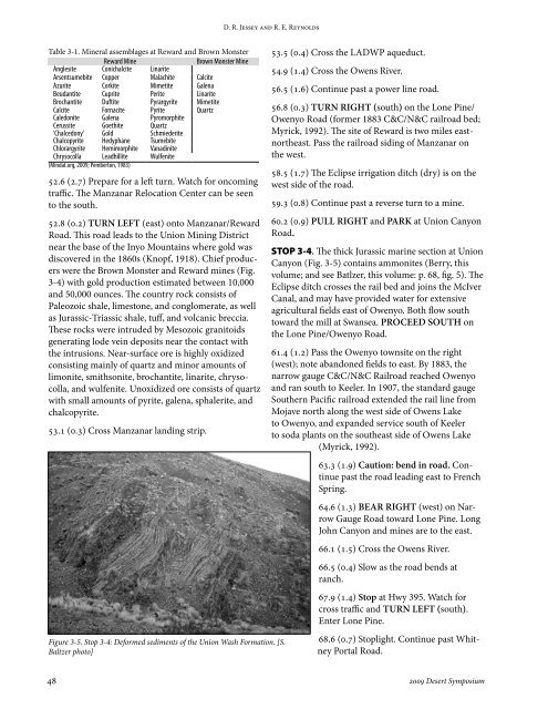
Figure 3-5. Stop 3-4: Deformed sediments of the Union Wash Form<strong>at</strong>ion. [S.<br />
Baltzer photo]<br />
53.5 (0.4) Cross the LADWP aqueduct.<br />
54.9 (1.4) Cross the Owens River.<br />
56.5 (1.6) Continue past a power line road.<br />
56.8 (0.3) TURN RIGHT (south) on the Lone Pine/<br />
Owenyo Road (former 1883 C&C/N&C railroad bed;<br />
Myrick, 1992). The site of Reward is two miles eastnortheast.<br />
Pass the railroad siding of M<strong>an</strong>z<strong>an</strong>ar on<br />
the west.<br />
58.5 (1.7) The Eclipse irrig<strong>at</strong>ion ditch (dry) is on the<br />
west side of the road.<br />
59.3 (0.8) Continue past a reverse turn to a mine.<br />
60.2 (0.9) PULL RIGHT <strong>an</strong>d PARK <strong>at</strong> Union C<strong>an</strong>yon<br />
Road.<br />
STOP 3-4. The thick Jurassic marine section <strong>at</strong> Union<br />
C<strong>an</strong>yon (Fig. 3-5) contains ammonites (Berry, this<br />
volume; <strong>an</strong>d see B<strong>at</strong>lzer, this volume: p. 68, fig. 5). The<br />
Eclipse ditch crosses the rail bed <strong>an</strong>d joins the McIver<br />
C<strong>an</strong>al, <strong>an</strong>d may have provided w<strong>at</strong>er for extensive<br />
agricultural fields east of Owenyo. Both flow south<br />
toward the mill <strong>at</strong> Sw<strong>an</strong>sea. PROCEED SOUTH on<br />
the Lone Pine/Owenyo Road.<br />
61.4 (1.2) Pass the Owenyo townsite on the right<br />
(west); note ab<strong>an</strong>doned fields to east. By 1883, the<br />
narrow gauge C&C/N&C Railroad reached Owenyo<br />
<strong>an</strong>d r<strong>an</strong> south to Keeler. In 1907, the st<strong>an</strong>dard gauge<br />
Southern Pacific railroad extended the rail line from<br />
Mojave north along the west side of Owens Lake<br />
to Owenyo, <strong>an</strong>d exp<strong>an</strong>ded service south of Keeler<br />
to soda pl<strong>an</strong>ts on the southeast side of Owens Lake<br />
(Myrick, 1992).<br />
63.3 (1.9) Caution: bend in road. Continue<br />
past the road leading east to French<br />
Spring.<br />
64.6 (1.3) BEAR RIGHT (west) on Narrow<br />
Gauge Road toward Lone Pine. Long<br />
John C<strong>an</strong>yon <strong>an</strong>d mines are to the east.<br />
66.1 (1.5) Cross the Owens River.<br />
66.5 (0.4) Slow as the road bends <strong>at</strong><br />
r<strong>an</strong>ch.<br />
67.9 (1.4) Stop <strong>at</strong> Hwy 395. W<strong>at</strong>ch for<br />
cross traffic <strong>an</strong>d TURN LEFT (south).<br />
Enter Lone Pine.<br />
68.6 (0.7) Stoplight. Continue past Whitney<br />
Portal Road.<br />
48 2009 Desert Symposium