Permanent Forest Plot Project (PFPP) - EREN
Permanent Forest Plot Project (PFPP) - EREN
Permanent Forest Plot Project (PFPP) - EREN

You also want an ePaper? Increase the reach of your titles
YUMPU automatically turns print PDFs into web optimized ePapers that Google loves.
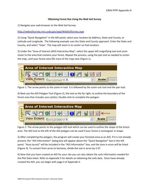
<strong>EREN</strong> <strong>PFPP</strong> Appendix IIIObtaining <strong>Forest</strong> Size Using the Web Soil Survey1) Navigate your web browser to the Web Soil Survey:http://websoilsurvey.nrcs.usda.gov/app/WebSoilSurvey.aspx2) Using “Quick Navigation” in the left panel, select your location by Address, State and County, orLatitude and Longitude. The following example uses the State and County approach. Enter the State andCounty, and select “View”. The map will zoom in to center on that location.3) Under the “Area of Interest (AOI) Interactive Map”, select the upper left magnifying tool and zoomcloser to the area that contains your forest. Repeat the process, using the pan tool as needed to centerthe map, until your forest area fills most of the map view (Figure 1).Figure 1. The arrow points to the zoom-in tool. It is followed by the zoom-out tool and the pan tool.4) Next use the AOI Polygon Tool (Figure 2), the tool as the far right, to outline the boundary of theforest area that includes your plot(s). Double click to complete the polygon.Figure 2. The arrow points to the polygon AOI tool which can be used to outline the shape of the forestarea. The AOI tool to the left of the AOI polygon can be used if your forest is rectangular in shape.5) After completing the polygon, the program will create your forested area as an AOI. If it is not alreadypresent, the “AOI Information” dialog box will appear above the “Quick Navigation” box in the leftpanel. “Area (acres)” will be included in the “AOI Information” box, and the area in acres will be listed(Figure 3). To convert from acres to hectares, divide the size in acres by 2.47.6) Now that you have created an AOI for your site you can also obtain the soils information needed forthe <strong>Plot</strong> Data sheet. Refer to Appendix II for details on obtaining the soils data. Since have alreadycreated the AOI, you can begin with page 4 of Appendix II.<strong>EREN</strong> <strong>Permanent</strong> <strong>Plot</strong> Protocols Version 1.04 (June 2012)