Appendix A - Urban Form Analysis: Canberra's Sustainability ...
Appendix A - Urban Form Analysis: Canberra's Sustainability ...
Appendix A - Urban Form Analysis: Canberra's Sustainability ...

You also want an ePaper? Increase the reach of your titles
YUMPU automatically turns print PDFs into web optimized ePapers that Google loves.
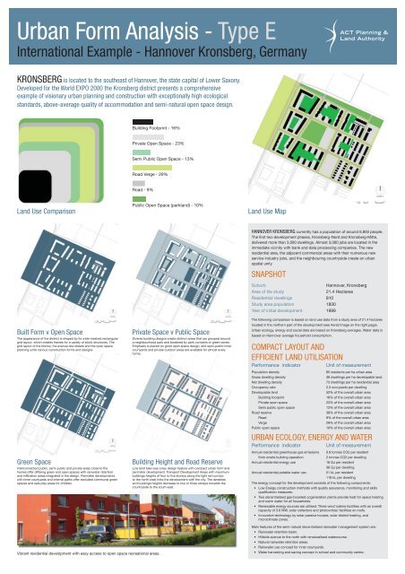
<strong>Urban</strong> <strong>Form</strong> <strong>Analysis</strong> - Type E<br />
International Example - Hannover Kronsberg, Germany<br />
KRONSBERG is located to the southeast of Hannover, the state capital of Lower Saxony.<br />
Developed for the World EXPO 2000 the Kronsberg district presents a comprehensive<br />
example of visionary urban planning and construction with exceptionally high ecological<br />
standards, above-average quality of accommodation and semi-natural open space design.<br />
Land Use Comparison Land Use Map<br />
Built <strong>Form</strong> v Open Space<br />
The appearance of the district is shaped by its wide-meshed rectangular<br />
grid layout, which creates frames for a variety of block structures. The<br />
grid layout of the blocks, the avenue-like streets and the open space<br />
planning unite various construction forms and designs<br />
Green Space<br />
Interconnected public, semi-public and private areas close to the<br />
homes offer differing green and open spaces with rainwater retention<br />
and infi ltration areas integrated in the design. Perimeter developments<br />
with inner courtyards and internal paths offer secluded communal green<br />
spaces and safe play areas for children.<br />
Building Footprint - 16%<br />
Private Open Space - 23%<br />
Vibrant residential development with easy access to open space recreational areas.<br />
Semi Public Open Space - 13%<br />
Road Verge - 29%<br />
Road - 9%<br />
Public Open Space (parkland) - 10%<br />
Private Space v Public Space<br />
Diverse building designs create distinct areas that are grouped around<br />
a neighbourhood park and bordered by park corridors or green zones.<br />
Emphasis is placed on good open space design, and semi-public inner<br />
courtyards and private outdoor areas are available for almost every<br />
home.<br />
Building Height and Road Reserve<br />
Low land take was a key design feature with compact urban form and<br />
perimeter development. Transport Development Areas with maximum<br />
buildings heights of four to fi ve storeys along the light rail corridor<br />
to the north-west links the development with the city. The densities<br />
and buildings heights decrease to two or three storeys towards the<br />
countryside to the south-east.<br />
HANNOVER KRONSBERG currently has a population of around 6,800 people.<br />
The fi rst two development phases, Kronsberg-Nord and Kronsberg-Mitte,<br />
delivered more than 3,000 dwellings. Almost 3,000 jobs are located in the<br />
immediate vicinity with bank and data processing companies. The new<br />
residential area, the adjacent commercial areas with their numerous new<br />
service industry jobs, and the neighbouring countryside create an urban<br />
spatial unity<br />
SNAPSHOT<br />
Suburb Hannover, Kronsberg<br />
Area of tile study 21.4 Hectares<br />
Residential dwellings 810<br />
Study area population 1830<br />
Year of initial development 1999<br />
The following comparison is based on land use data from a study area of 21.4 hectares<br />
located in the northern part of the development (see Aerial Image on the right page).<br />
<strong>Urban</strong> ecology, energy and social data are based on Kronsberg averages. Water data is<br />
based on Hannover average household consumption.<br />
COMPACT LAYOUT AND<br />
EFFICIENT LAND UTILISATION<br />
Performance indicator Unit of measurement<br />
Population density 85 residents per ha urban area<br />
Gross dwelling density 38 dwellings per ha developable land<br />
Net dwelling density 73 dwellings per ha residential area<br />
Occupancy rate 2.3 occupants per dwelling<br />
Developable land 52% of the overall urban area<br />
Building footprint 16% of the overall urban area<br />
Private open space 23% of the overall urban area<br />
Semi public open space 13% of the overall urban area<br />
Road reserve 38% of the overall urban area<br />
Road 9% of the overall urban area<br />
Verge 29% of the overall urban area<br />
Public open space 10% of the overall urban area<br />
URBAN ECOLOGY, ENERGY AND WATER<br />
Performance indicator Unit of measurement<br />
Annual residential greenhouse gas emissions 0.9 tonnes CO2 per resident<br />
from onsite building operation 2 tonnes CO2 per dwelling<br />
Annual residential energy use 16 GJ per resident<br />
36 GJ per dwelling<br />
Annual residential potable water use 51 kL per resident<br />
116 kL per dwelling<br />
The energy concept for the development consists of the following components:<br />
• Low Energy construction methods with quality assurance, monitoring and skills<br />
qualifi cation measures.<br />
• Two decentralised gas-boosted cogeneration plants provide heat for space heating<br />
and warm water for all households.<br />
• Renewable energy sources are utilised: Three wind turbine facilities with an overall<br />
capacity of 3.6 MW, solar collectors and photovoltaic facilities on roofs.<br />
• Innovative technology by solar passive houses, solar district heating, and<br />
microclimate zones.<br />
Main features of the semi-natural decentralised rainwater management system are:<br />
• Rainwater retention basin.<br />
• Hillside avenue to the north with renaturalised watercourse.<br />
• Natural rainwater retention areas.<br />
• Rainwater use concept for inner courtyards.<br />
• Water harvesting and saving concept in school and community centre.
![HSR Training Programs Guidelines [ PDF 191KB]](https://img.yumpu.com/51348280/1/190x245/hsr-training-programs-guidelines-pdf-191kb.jpg?quality=85)


![Teachers Technical and Further Education [ PDF 68KB]](https://img.yumpu.com/34230751/1/184x260/teachers-technical-and-further-education-pdf-68kb.jpg?quality=85)