Appendix A - Urban Form Analysis: Canberra's Sustainability ...
Appendix A - Urban Form Analysis: Canberra's Sustainability ...
Appendix A - Urban Form Analysis: Canberra's Sustainability ...

Create successful ePaper yourself
Turn your PDF publications into a flip-book with our unique Google optimized e-Paper software.
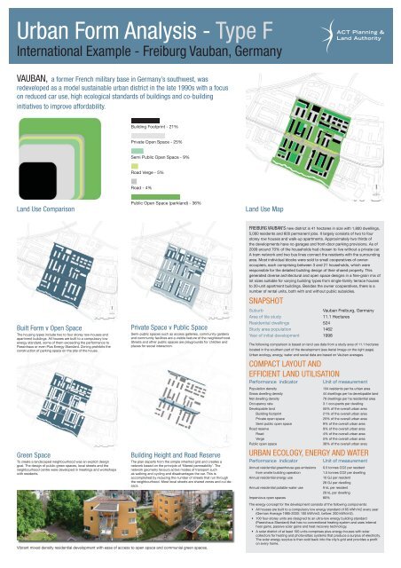
<strong>Urban</strong> <strong>Form</strong> <strong>Analysis</strong> - Type F<br />
International Example - Freiburg Vauban, Germany<br />
VAUBAN, a former French military base in Germany’s southwest, was<br />
redeveloped as a model sustainable urban district in the late 1990s with a focus<br />
on reduced car use, high ecological standards of buildings and co-building<br />
initiatives to improve affordability.<br />
Land Use Comparison Land Use Map<br />
Built <strong>Form</strong> v Open Space<br />
The housing types include two to four storey row-houses and<br />
apartment buildings. All houses are built to a compulsory low<br />
energy standard, some of them exceeding the performance to<br />
Passivhaus or even Plus Energy Standard. Zoning prohibits the<br />
construction of parking space on the site of the house.<br />
Green Space<br />
To create a landscaped neighbourhood was an explicit design<br />
goal. The design of public green spaces, local streets and the<br />
neighbourhood centre were developed in meetings and workshops<br />
with residents.<br />
Building Footprint - 21%<br />
Private Open Space - 25%<br />
Semi Public Open Space - 9%<br />
Road Verge - 5%<br />
Road - 4%<br />
Public Open Space (parkland) - 36%<br />
Private Space v Public Space<br />
Semi-public spaces such as access galleries, community gardens<br />
and community facilities are a visible feature of the neighbourhood.<br />
Streets and other public spaces are playgrounds for children and<br />
places for social interaction.<br />
Building Height and Road Reserve<br />
The plan departs from the simple inherited grid and creates a<br />
network based on the principle of ‘fi ltered permeability’. The<br />
network geometry favours active modes of transport such<br />
as walking and cycling and disadvantages the car. This is<br />
accomplished by reducing the number of streets that run through<br />
the neighbourhood. Most local streets are shared zones and cul-desacs.<br />
Vibrant mixed density residential development with ease of access to open space and communial green spaces.<br />
FREIBURG VAUBAN’S new district is 41 hectares in size with 1,800 dwellings,<br />
5,000 residents and 600 permanent jobs. It largely consists of two to four<br />
storey row houses and walk-up apartments. Approximately two thirds of<br />
the developments have no garages and front-door parking provisions. As of<br />
2009 around 70% of the households had chosen to live without a private car.<br />
A tram network and two bus lines connect the residents with the surrounding<br />
area. Most individual blocks were sold to small cooperatives of owneroccupiers,<br />
each comprising between 3 and 21 households, which were<br />
responsible for the detailed building design of their shared property. This<br />
generated diverse architectural and open space designs in a fi ne-grain mix of<br />
lot sizes suitable for varying building types from single-family terrace houses<br />
to 20-unit apartment buildings. Besides the owner cooperatives, there is a<br />
number of rental units, both with and without public subsidies.<br />
SNAPSHOT<br />
Suburb Vauban Freiburg, Germany<br />
Area of tile study 11.1 Hectares<br />
Residential dwellings 524<br />
Study area population 1462<br />
Year of initial development 1998<br />
The following comparison is based on land use data from a study area of 11.1 hectares<br />
located in the southern part of the development (see Aerial Image on the right page).<br />
<strong>Urban</strong> ecology, energy, water and social data are based on Vauban averages.<br />
COMPACT LAYOUT AND<br />
EFFICIENT LAND UTILISATION<br />
Performance indicator Unit of measurement<br />
Population density 134 residents per ha urban area<br />
Gross dwelling density 44 dwellings per ha developable land<br />
Net dwelling density 79 dwellings per ha residential area<br />
Occupancy rate 3.1 occupants per dwelling<br />
Developable land 55% of the overall urban area<br />
Building footprint 21% of the overall urban area<br />
Private open space 25% of the overall urban area<br />
Semi public open space 9% of the overall urban area<br />
Road reserve 9% of the overall urban area<br />
Road 4% of the overall urban area<br />
Verge 5% of the overall urban area<br />
Public open space 36% of the overall urban area<br />
URBAN ECOLOGY, ENERGY AND WATER<br />
Performance indicator Unit of measurement<br />
Annual residential greenhouse gas emissions 0.5 tonnes CO2 per resident<br />
from onsite building operation 1.5 tonnes CO2 per dwelling<br />
Annual residential energy use 10 GJ per resident<br />
28 GJ per dwelling<br />
Annual residential potable water use 9 kL per resident<br />
29 kL per dwelling<br />
Impervious open spaces 80%<br />
The energy concept for the development consists of the following components:<br />
• All houses are built to a compulsory low energy standard of 65 kWh/m2 every year<br />
(German Average 1995-2000: 100 kWh/m2, before: 200 kWh/m2).<br />
• 100 four-storey units are designed to an ultra-low energy building standard<br />
(Passivhaus Standard) that has no conventional heating system and uses internal<br />
heat gains, passive solar gains and heat recovery technology.<br />
• A solar district of at least 100 units comprises plus-energy-houses with solar<br />
collectors for heating and photovoltaic systems that produce a surplus of electricity.<br />
The solar energy surplus is then sold back into the city’s grid and provides a profi t<br />
on every home.

![HSR Training Programs Guidelines [ PDF 191KB]](https://img.yumpu.com/51348280/1/190x245/hsr-training-programs-guidelines-pdf-191kb.jpg?quality=85)


![Teachers Technical and Further Education [ PDF 68KB]](https://img.yumpu.com/34230751/1/184x260/teachers-technical-and-further-education-pdf-68kb.jpg?quality=85)