Structure Plan - Rural City of Murray Bridge
Structure Plan - Rural City of Murray Bridge
Structure Plan - Rural City of Murray Bridge

Create successful ePaper yourself
Turn your PDF publications into a flip-book with our unique Google optimized e-Paper software.
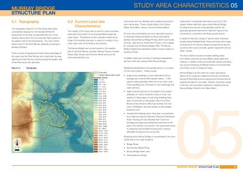
STUDY AREA CHARACTERISTICS 055.1 TopographyThe topography (Figure 5.1) <strong>of</strong> the Study Area variesconsiderably ranging from the elevated White Hillescarpment to the west, the generally fl at form <strong>of</strong> theexisting urban area to the low lying dairy fl ats located onthe eastern side <strong>of</strong> the River <strong>Murray</strong>. The Town Centreslopes down to the River <strong>Murray</strong>, generally providing anelevated interface.There is a lack <strong>of</strong> development which takes advantage <strong>of</strong>the views over the River <strong>Murray</strong> and in particular the areaadjoining the Rail Precinct and land along the eastern side<strong>of</strong> the River above the dairy fl ats.Figure 5.1: Topography5.2 Current Land UseCharacteristicsThe majority <strong>of</strong> the Study Area is used for urban purposes,particularly that portion <strong>of</strong> the area identifi ed as plannedurban lands. The balance <strong>of</strong> land, typically located at thefringe <strong>of</strong> the existing township, is used for a variety <strong>of</strong> nonurbanuses such as horticulture and industry.The <strong>Murray</strong> <strong>Bridge</strong> town centre located on the westernside <strong>of</strong> the River <strong>Murray</strong>, between Railway Terrace, CharlesStreet, Mary Terrace and Florence Street serves as themain administrative core.Community and civic facilities have clustered around the Collectively it is estimated that there is around 27,000town centre area. These include shops, Civic Centre square metres retail fl oor space within <strong>Murray</strong> <strong>Bridge</strong>.Offi ce, Post Offi ce, Library, Court and Police Station.It is likely that economic and population growth willgenerate signifi cant demand for retail fl oor space in theSchools are concentrated around an education precinct convenience, comparison and bulky goods sectors.on Swanport Road and Mannum Road. EducationalIn addition there are a range <strong>of</strong> ‘service trade’ premisesfacilities include <strong>Murray</strong> <strong>Bridge</strong> Primary, (North and South)located along Adelaide Road. These premises sell a rangeSchools, High School, Fraser Park Primary, Unity College,<strong>of</strong> products for the service trades and agricultural sectorsSt. Josephs and the <strong>Murray</strong> <strong>Bridge</strong> TAFE. The <strong>Murray</strong>as well as items such as boats, garden equipment and car<strong>Bridge</strong> Hospital and ambulance station is also located onsales / repairs.Swanport Road.The Town Centre and service trades retailing areasIn addition there are a number <strong>of</strong> existing kindergartens form distinct precincts serving different retail needs andand four child care centres within <strong>Murray</strong> <strong>Bridge</strong>.markets. In addition there are small retail clusters providingtop up local shopping at Mitchell Avenue on the east sideResidential development has typically grown in a number and further south on Swanport Road.<strong>of</strong> forms and location. These include:<strong>Murray</strong> <strong>Bridge</strong> is at the centre <strong>of</strong> a major agricultural• single storey dwellings on town allotments with an district which supports irrigated horticulture and dairyingaverage size <strong>of</strong> around 800 square metres – 1,000 along the River <strong>Murray</strong> and cropping and intensive animalsquare metres generally within the ‘inner urban’ area. keeping throughout rural areas. Industry, including a rangeThese dwellings are connected to town sewerage and <strong>of</strong> primary and secondary industries is clustered aroundwater services;<strong>Murray</strong> <strong>Bridge</strong>, Monarto and Tailem Bend.• larger rural living blocks on the eastern and westernperiphery <strong>of</strong> 1 and 2 hectares in area or more. Themajority <strong>of</strong> these types <strong>of</strong> rural living dwellings havebeen constructed on the eastern side <strong>of</strong> the River<strong>Murray</strong> where the land <strong>of</strong>fers high amenity and river05views. Dwellings in this area require on site sewagetreatment; and• Housing SA dwellings which have been concentratedin an area bounded by Swanport Road and HindmarshRoad. Housing SA has indicated that it does notenvisage any large scale additional investment in thisarea in the medium to long term. The opportunity existsto redevelop and revitalise housing and to achieveaffordable housing for the community.Shopping within <strong>Murray</strong> <strong>Bridge</strong> is concentrated in the towncentre area in four main locations:• <strong>Bridge</strong> Street;• Woolworths Market Place;• <strong>Murray</strong> <strong>Bridge</strong> Green; and• Coles (Mannum Road).21