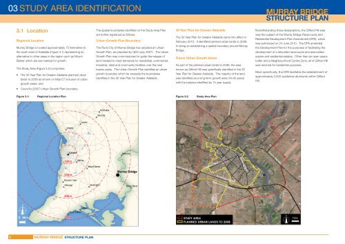
STUDY AREA IDENTIFICATION3.1 LocationRegional Location<strong>Murray</strong> <strong>Bridge</strong> is located approximately 75 kilometres tothe south-east <strong>of</strong> Adelaide (Figure 3.1) representing anThe spatial boundaries identifi ed on the Study Area <strong>Plan</strong>are further explained as follows.Urban Growth <strong>Plan</strong> BoundaryThe <strong>Rural</strong> <strong>City</strong> <strong>of</strong> <strong>Murray</strong> <strong>Bridge</strong> has adopted an UrbanGrowth <strong>Plan</strong>, as prepared by QED (July 2007). The Urban30 Year <strong>Plan</strong> for Greater AdelaideThe 30 Year <strong>Plan</strong> for Greater Adelaide came into effect inFebruary 2010. It identifi ed planned urban lands to 2038.In doing so establishing a spatial boundary around <strong>Murray</strong><strong>Bridge</strong>.Notwithstanding these designations, the Gifford Hill areawas the subject <strong>of</strong> the <strong>Murray</strong> <strong>Bridge</strong> Racecourse andResidential Development <strong>Plan</strong> Amendment (DPA), whichwas authorized on 24 June 2010. The DPA amendedthe Development <strong>Plan</strong> for the purposes <strong>of</strong> facilitating thedevelopment <strong>of</strong> a relocated racecourse and associatedalternative to other areas in the region such as MountBarker which are ear-marked for growth.Growth <strong>Plan</strong> was commissioned to guide the release <strong>of</strong>land needed to meet demands for residential, commercial,Future Urban Growth Areasequine and residential estates. Other than an open spacebuffer and a Neighbourhood Centre Zone, all <strong>of</strong> Gifford HillThe Study Area (Figure 3.2) comprises:• The 30 Year <strong>Plan</strong> for Greater Adelaide planned urbanlands to 2038 as shown on Map E7 inclusive <strong>of</strong> urbangrowth areas; andindustrial, retail and community facilities over the nexttwenty years. The Urban Growth <strong>Plan</strong> identifi es an urbangrowth boundary which far exceeds the boundariesidentifi ed in the 30 Year <strong>Plan</strong> for Greater Adelaide.As part <strong>of</strong> the planned urban lands to 2038, the areaknown as Gifford Hill was specifi cally identifi ed in the 30Year <strong>Plan</strong> for Greater Adelaide. The majority <strong>of</strong> the landwas identifi ed as a long term growth area (16-30 years)with the balance identifi ed as 15 year supply.was rezoned for residential purposes.More specifi cally, the DPA facilitates the establishment <strong>of</strong>approximately 3,500 residential allotments within GiffordHill.• Council’s (2007) Urban Growth <strong>Plan</strong> boundary.Figure 3.1:Regional Location <strong>Plan</strong>Figure 3.2:Study Area <strong>Plan</strong>6
STRATEGIC CONTEXT 04This section considers the relevant strategicframework and policy settings which will infl uencethe <strong>Structure</strong> <strong>Plan</strong>. The strategic framework includesState, Regional and Local level policies.Some <strong>of</strong> these documents identify population targetsand projections.Population targets are aspirational indicatorsused for strategic planning purposes and are notforecasts <strong>of</strong> the future. Population projectionsare intended to illustrate the consequences <strong>of</strong>selected assumptions on the size, age structureand geographic distribution <strong>of</strong> population andare <strong>of</strong>ten based on data/trends drawn frompreceding years.4.1 State4.1.1 South Australia Strategic <strong>Plan</strong>South Australia’s Strategic <strong>Plan</strong> outlines a mediumto long-term vision for the whole <strong>of</strong> South Australia.It has two important, complementary roles. Firstly, itprovides a framework for the activities <strong>of</strong> the SouthAustralian Government, business and the entireSouth Australian community. Secondly, it is a meansfor tracking progress state-wide, with the targetsacting as points <strong>of</strong> reference that can be assessedperiodically.The Strategic <strong>Plan</strong> does not contain any specifi c referenceto the Study Area. However the <strong>Plan</strong> does expressthemes which are relevant to the planning within the StudyArea. The investigations recognize and support SouthAustralia’s Strategic <strong>Plan</strong>, and ensure future policy willassist in achieving key goals and targets.The Strategic <strong>Plan</strong> sets out six objectives each with itsown suite <strong>of</strong> targets. The relevant targets <strong>of</strong> particularrelevance to these <strong>Structure</strong> <strong>Plan</strong> investigations areoutlined as follows:Target 45: Total populationIncrease South Australia’s population to 2 million by 2027(baseline: 2003)Target 46: Regional population levelsIncrease regional populations, outside <strong>of</strong> Greater Adelaide,by 20 000 to 320 000 or more by 2020 (baseline: 2010)Target 47: JobsIncrease employment by 2% each year from 2010 to 2016(baseline: 2010)Target 56: Strategic infrastructureEnsure the provision <strong>of</strong> key economic and socialinfrastructure accommodates population growth (baseline:2010-11)Target 73: Recycled stormwaterSouth Australia has the system capacity to harvest up to35 GL <strong>of</strong> stormwater per annum by 2025 (baseline: 2009)Target 74: Recycled wastewaterSouth Australia has the system capacity to recycle up to50 GL <strong>of</strong> wastewater per annum by 2025 (baseline: 2009)Target 75: Sustainable water useSouth Australia’s water resources are managed withinsustainable limits by 2018 (baseline: 2003)Target 76: River <strong>Murray</strong> – fl ows*Increase environmental fl ows in the River <strong>Murray</strong> by aminimum <strong>of</strong> 1,500 GL by 2018 (baseline: 2003)Target 77: River <strong>Murray</strong> – salinityThe components <strong>of</strong> the 30 Year <strong>Plan</strong> for Greater Adelaide<strong>of</strong> most relevance to formulating a land use planningSouth Australia maintains a positive balance on theframework for <strong>Murray</strong> <strong>Bridge</strong> are outlined below.<strong>Murray</strong>-Darling Basin Authority salinity register (baseline:2008)4.1.2 The 30 Year <strong>Plan</strong> for Greater AdelaideIn relation to expected changes to the size andcomposition <strong>of</strong> the population the 30 Year <strong>Plan</strong> for GreaterAdelaide sets out the following:• a total forecast population for Greater Adelaide <strong>of</strong> 1.85million people by 2036 (the population is growing fasterthan was forecast in South Australia’s Strategic <strong>Plan</strong>(2004) and the Prosperity Through People populationpolicy (2004), which both forecast a target <strong>of</strong> 2 millionpeople by 2050 for the entire state. This is nowprojected to be reached 23 years ahead <strong>of</strong> target, in2027;)• Greater Adelaide’s population is older than theAustralian average and the share <strong>of</strong> people aged over65 is growing faster than the national average:– those aged over 65 will increase from 194,000 inThe 30 Year <strong>Plan</strong> for Greater Adelaide: A volume <strong>of</strong> theSA <strong>Plan</strong>ning Strategy took effect in February 2010 andpresents current State Government planning policyfor development. It also indicates directions for futuredevelopment to the community, the private sector andlocal government.––2006 to 407,000 in 2036, a 110 per cent increasethe proportion <strong>of</strong> aged people (over 65 years) in thepopulation will increase from 18 per cent in 2006 to22 per cent in 2036the number <strong>of</strong> South Australians aged 85 yearsor more is projected to increase by 222 percent by 2036, with those living in non-privateThe 30 Year <strong>Plan</strong> for Greater Adelaide aims to:accommodation projected to increase by morethan 220 per cent from about 10,000 in 2006 to in• outline how the South Australian Government proposes04excess <strong>of</strong> 31,000 in 2036;to balance population and economic growth with theneed to preserve the environment and protect theheritage, history and character <strong>of</strong> Greater Adelaide.• seeks to create inclusive, vibrant and livablecommunities, while protecting the regional hinterlandsand primary production lands and sustaining naturalresources.• assists the State Government, local government andthe entire community in building resilience to the risksand impacts <strong>of</strong> climate change.• provides context on a number <strong>of</strong> main themesincluding population characteristics, form <strong>of</strong> newdevelopment and employment.7