- Page 1 and 2:
University of Nevada, RenoForest Mo
- Page 4 and 5:
iTHESIS ABSTRACTWidespread and sync
- Page 6 and 7:
iiimiddle and upper-elevation fores
- Page 8 and 9:
vpine (Pinus albicaulis) forests of
- Page 10 and 11:
viiACKNOWLEDGMENTS: Primary financi
- Page 12 and 13:
ixPlate 2. Photograph of mountain p
- Page 14 and 15:
xiForest Types and Ecoregions......
- Page 16 and 17:
xiiiAPPENDIX A. 25 years of annual
- Page 18 and 19:
xvefficiency measures agreement bet
- Page 20 and 21:
xviimortality; Negative DDM: decrea
- Page 22 and 23:
xixratios greater than one indicate
- Page 24 and 25:
2ABSTRACTIncreased stand density is
- Page 26 and 27:
4rise to outbreaks of widespread mo
- Page 28 and 29:
6of compounds and structures necess
- Page 30 and 31: 8landscapes (Logan et al. 1998; Nel
- Page 33 and 34: 11(Sierra Nevada) of the LTB with m
- Page 35 and 36: 13treatment areas were also exclude
- Page 37 and 38: 15We evaluated the accuracy of mode
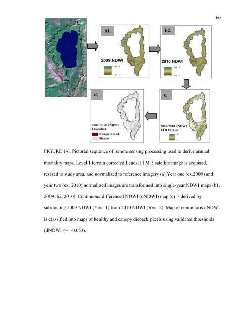
- Page 39 and 40: 17field data. In early fall of 2010
- Page 41 and 42: 19gray canopies, a result of the co
- Page 43 and 44: 21established five climatic periods
- Page 45 and 46: 23far greater during the first drou
- Page 47 and 48: 25slightly more frequent during the
- Page 49 and 50: 27but persistent factor for forest
- Page 51 and 52: 29For sugar pine, mortality risk in
- Page 53 and 54: 31treatments to be variable, incons
- Page 55 and 56: 33Baret, F. and G. Guyot. 1991. Pot
- Page 57 and 58: 35Das, Adrian, John Battles, Nathan
- Page 59 and 60: 37Fettig, Christopher J., Robert R.
- Page 61 and 62: 39Huete, A.R., H.Q. Liu, K. Batchil
- Page 63 and 64: 41Loomis W E. 1932. Growth-differen
- Page 65 and 66: 43Moritz, Max A., Paul F. Hessburg,
- Page 67 and 68: 45Scholl, Andrew E. and Alan H. Tay
- Page 69 and 70: 47van Mantgem, P.J., Stephenson, N.
- Page 71 and 72: 49Table 1-1. Description of LTB for
- Page 73 and 74: 51TABLE 1-3a,b. Validation of remot
- Page 75 and 76: 53TABLE 1-5. Summary of odds-ratios
- Page 77 and 78: FIGURE 1-1. Location of Lake Tahoe
- Page 79 and 80: 57a.b.FIGURE 1-3a, b. LAI Validatio
- Page 84 and 85: 62FIGURE 1-8. Mortality levels and
- Page 86 and 87: 64FIGURE 1-10. Direction and magnit
- Page 88 and 89: 66FIGURE 1-12. Number of models whe
- Page 90 and 91: Ratio: Positive DDM:Negative DDM681
- Page 92 and 93: 70FIGURE 1-16. Average odds ratio f
- Page 94 and 95: 72APPENDIX A. 95 th Percentile of L
- Page 96 and 97: 19801982198419861988199019921994199
- Page 98 and 99: 76APPENDIX C. Final models in five
- Page 100 and 101: 78ForestType Year Model LRT ModelTy
- Page 102 and 103: 80Chapter 2 - Spatial and Temporal
- Page 105 and 106: 83mountainous regions of snow-domin
- Page 107 and 108: 85McDowell et al. 2008; Rice et al.
- Page 109 and 110: 87periods in the same forest may re
- Page 111 and 112: 89Forest Types and EcoregionsWe exa
- Page 113 and 114: 91Environmental VariablesIn additio
- Page 115 and 116: 93(Figure 2-6). Forest mortality ma
- Page 117 and 118: 95In JP forests, decreases in eleva
- Page 119 and 120: 97that abrupt declines in growth ar
- Page 121 and 122: 99and d2) and increased temperature
- Page 123 and 124: 101concentrated at lower elevations
- Page 125 and 126: 103responses may be due to the grea
- Page 127 and 128: 105Berg, Edward E, J. David Henry,
- Page 129 and 130: 107from 1991-1996 near Spooner Lake
- Page 131 and 132:
109Hansen, E., Bentz, B. and Turner
- Page 133 and 134:
111reference to historical disturba
- Page 135 and 136:
113Ogle, Kiona, Thomas G. Whitham,
- Page 137 and 138:
115SNEP [Sierra Nevada Ecosystem Pr
- Page 139 and 140:
117Vygodskaya, N.N., E.D. Schulze,
- Page 141 and 142:
119ForestType Coefficients Standar
- Page 143 and 144:
121a.b.c.d.FIGURE 2-1. Ecoregions (
- Page 145 and 146:
123FIGURE 2-3. Solar radiation (WH/
- Page 147 and 148:
125FIGURE 2-5. Boxplots of annual m
- Page 149 and 150:
127FIGURE 2-7. Effect plots for Ann
- Page 151 and 152:
129a: JPb: MFc: RFFIGURE 2-9a-c. Le
- Page 153 and 154:
131FIGURE 2-11. Location of increas
- Page 155 and 156:
133FIGURE 2-13. Location of increas
- Page 157 and 158:
1351993-94 1994-95 1995-96 1996-971
- Page 159 and 160:
137THESIS SUMMARYForest mortality i