IRA~IANeURBANHOWOAR nSAILABYENGIJEH =~38.25eAQZIARATZOLA
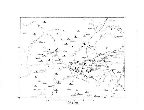
1930SALMAS EARTHQUAKE 275about 40 churches were destroyed or damaged (Tables 1 and 2). Casualties, which occurrednearly exclusively amongst the section of the population which had not heededthe foreshock, amounted to about 2,514 killed (Table 1). Two surface faults were formedwith the earthquake: the first, oriented NW-SE and located at the southern edgeof the Salmas Plain, was about 20km long and displayed a maximum right-lateral movementof 4m and a maximum vertical throw (NE down) of about 5m; the second,oriented NE-SW and located in the western mountains, was over 3km long, leftlateral,and had a vertical throw (NW down) of about lm. A recent recalculationlocated the instrumental epicentre at 38°.22’N, 44°.66’E (Nabavi 1972), which isclose agreement with the centre of the region of maximum destruction (macroseismicepicentre), found in this study to be approximately 38 °. 15’N, 44°.70’E. Hence foreshockand main shock had, to a first approximation, nearly identical epicentres.Outside the epicentral region, Khoy, Qutur, and Sharafkhaneh were slightlydamaged. In Tabriz, the shock caused panic, and part of the population fled the town.In the north, it was felt with intensities between 4 and 6 bals in Julfa (Medvedev, 1953),Nakhichevan, Ordubad, and was even reported as felt in Leninakan and Tiflis. NearJulfa (North Iran), the eastern wall of S.Stephanos developed a vertical central crack(Fig. 4), probably as a result of unequal foundation settlement. In the west the shockwas felt in Bashkaleh and as far as Van in Turkey, and in the south as far as SavejBulaq (Mahabad).3.2. Eyewitness account,The main shock was witnessed by Abel Zayia, a Persian Lazarist of the FrenchMission in Rezaiyeh to investigate the damage in Salmas. The account given refers tothe effects as felt in the southeastern part of the epicentral region, at a point on theRezaiyeh-Dilman road just north of the present-day village of Aliabad, and southof the isolated mountain (marked 1628 in Figs. 2 and 3) which contains a well-knownSassanian bas-relief. The extracts which follow are translated from the French by thepresent authors."At half-past one in the morning we were just in front of the Suratis mountain(bas-relief), one of the car’s headlights broke-down and the driver got out to repairit. Suddenly I felt the car shake and thrown-upwards; it was projected from south tonorth and displaced by 50 cm (Zayia 1930b, is more precise:" it (the car) was projected50cm sideways"). The driver was thrown down onto the ground" (Zayia, 1930a). "Thedriver was lying on the road. I thought that the car was out of control and instinctivelyreached for the brake and ignition key, when I heard a terrible noise: it was the rocksrolling down from the mountain. I quickly got out of the car, but what difficulty toremain standing! Not being able to advance, or go back, we waited for two hours;I looked upwards to see the apparition of the sign of the Son of Man. During this timeFig. 3. (Facing Page) Main shock of 6 May 1930.Village destruction estimated at:$ 75-100% O 25-75°,/o O 0-25°/o O 0°/o * no information avuilabl~Damage to churches:~ destroyed ~ partly destroyed ~ fissured ~,an.damaged"r church destroyed before 1930-- fault-break gchanged thermal spring ...... rockfalllandslide or rockslide w = waterlogging d = springs decreased i = springs increasedHT Haftavan Tepe, DT Drishik Tepe. New (post-1930) villages shown as squares. Heights ilx meters.