Land East of Parsonage Lane, South Molton - North Devon District ...
Land East of Parsonage Lane, South Molton - North Devon District ...
Land East of Parsonage Lane, South Molton - North Devon District ...

Create successful ePaper yourself
Turn your PDF publications into a flip-book with our unique Google optimized e-Paper software.
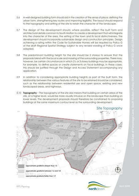
5.6 A well-designed building form should aid in the creation <strong>of</strong> the sense <strong>of</strong> place; defining theurban form, strengthening key routes and improving legibility. The layout should respondto the topography and setting <strong>of</strong> the site to retain the character <strong>of</strong> the landscape.5.7 The design <strong>of</strong> the development should, where possible, reflect the built form andarchitectural details common to <strong>South</strong> <strong>Molton</strong> to create a development that will integrateinto the character <strong>of</strong> the area, the setting <strong>of</strong> the town and its local distinctiveness. Thedevelopment should incorporate sustainable design and construction principles. Designachieving a rating within the Code for Sustainable Homes will be required by Policy G<strong>of</strong> the draft Regional Spatial Strategy subject to any revised wording <strong>of</strong> Policy G onceadopted.5.8 The predominant building height for the site should be 2 storeys to ensure that theproposals blend with the local scale and massing <strong>of</strong> the surrounding properties. There may,however, be certain circumstances in which 2½ or 3 storey buildings may be appropriate,for example, to define spaces or create statements on focal buildings. In these cases,this should be justified through the Design and Access Statement accompanying anyapplication.5.9 In addition to considering appropriate building heights as part <strong>of</strong> the built form, therelationship between the various features <strong>of</strong> the site to be retained should be considered,such as the relationship between residential use and open space, existing and newlandscaped areas, and highways.5.10 Topography – The topography <strong>of</strong> the site also means that building on certain areas <strong>of</strong> thesite, at a higher level, would be more visually intrusive on the landscape than building onlower levels. The development proposals should therefore be constrained to proposingbuildings at the same maximum contour level as the surrounding development.Site Topography15<strong>Land</strong> <strong>East</strong> <strong>of</strong> <strong>Parsonage</strong> <strong>Lane</strong>, <strong>South</strong> <strong>Molton</strong> (Policy SMO2d) ADOPTED DEVELOPMENT BRIEFapproximate gradients steeper than 1:5napproximate gradients between 1:6 and 1:8approximate gradients flatter than 1:9RPS PlanningApril 2008