Stormwater Source Control Design Guidelines 2005 - Waterbucket
Stormwater Source Control Design Guidelines 2005 - Waterbucket
Stormwater Source Control Design Guidelines 2005 - Waterbucket

Create successful ePaper yourself
Turn your PDF publications into a flip-book with our unique Google optimized e-Paper software.
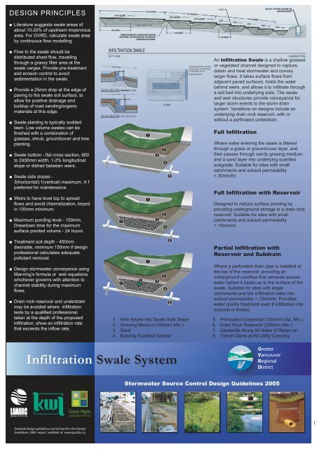
DESIGN PRINCIPLES■ Literature suggests swale areas ofabout 10-20% of upstream imperviousarea. For GVRD, calculate swale areaby continuous flow modelling.2% SLOPE2.0% SLOPELEVEL BASE (TYP)10m MAXTRENCH DAM OF COMPACTEDNATIVEMATERIAL OR EQUIVALENT TO CREATESUBSURFACE BASIN2.0% SLOPE10m MAXWEIR5%SLOPE SLOPE2.0% SLOPE10%2.0%2.0%2.0%5m MAXOUTLET TO PIPE SYSTEM ORWATERCOURSE2.0%2.0%■ Flow to the swale should bedistributed sheet flow, travellingthrough a grassy filter area at theswale verges. Provide pre-treatmentand erosion control to avoidsedimentation in the swale.■ Provide a 25mm drop at the edge ofpaving to the swale soil surface, toallow for positive drainage andbuildup of road sanding/organicmaterials at this edge.■ Swale planting is typically soddedlawn. Low volume swales can befinished with a combination ofgrasses, shrub, groundcover and treeplanting.■ Swale bottom - flat cross section, 600to 2400mm width, 1-2% longitudinalslope or dished between weirs.■ Swale side slopes -3(horizontal):1(vertical) maximum, 4:1preferred for maintenance.■ Weirs to have level top to spreadflows and avoid channelization, keyedin 100mm minimum.■ Maximum ponding level - 150mm.Drawdown time for the maximumsurface ponded volume - 24 hours.ADJACENT GRADERETENTIO7PLAN123481236 4PROVIDE EROSION CONTROLALONG SIDES OF WEIR ANDAT DRAINAGE INLETSCONCRETE WEIRAn Infiltration Swale is a shallow grassedor vegetated channel designed to capture,detain and treat stormwater and conveylarger flows. It takes surface flows fromadjacent paved surfaces, holds the waterbehind weirs, and allows it to infiltrate througha soil bed into underlying soils. The swaleand weir structures provide conveyance forlarger storm events to the storm drainsystem. Variations on designs include anunderlying drain rock reservoir, with orwithout a perforated underdrain.Full InfiltrationWhere water entering the swale is filteredthrough a grass or groundcover layer, andthen passes through sandy growing mediumand a sand layer into underlying scarifiedsubgrade. Suitable for sites with smallcatchments and subsoil permeability> 30mm/hr.Full Infiltration with Reservoir<strong>Design</strong>ed to reduce surface ponding byproviding underground storage in a drain rockreservoir. Suitable for sites with smallcatchments and subsoil permeability> 15mm/hr.■ Treatment soil depth - 450mmdesirable, minimum 150mm if designprofessional calculates adequatepollutant removal.■ <strong>Design</strong> stormwater conveyance usingManning’s formula or weir equationswhichever governs with attention tochannel stability during maximumflows.■ Drain rock reservoir and underdrainmay be avoided where infiltrationtests by a qualified professional,taken at the depth of the proposedinfiltration, show an infiltration ratethat exceeds the inflow rate.751236 41. Weir Keyed into Swale Side Slope2. Growing Medium (300mm Min.)3. Sand4. Existing Scarified Subsoil88Partial Infiltration withReservoir and SubdrainWhere a perforated drain pipe is installed atthe top of the reservoir, providing anunderground overflow that removes excesswater before it backs up to the surface of theswale. Suitable for sites with largercatchments and low infiltration rates intosubsoil permeability < 15mm/hr. Provideswater quality treatment even if infiltration intosubsoils is limited.5. Perforated Underdrain (150mm Dia. Min.)6. Drain Rock Reservoir (300mm Min.)7. Geotextile Along All Sides of Reservoir8. Trench Dams at All Utility CrossingInfiltration Swale SystemGreaterVancouverRegionalDistrict<strong>Stormwater</strong> <strong>Source</strong> <strong>Control</strong> <strong>Design</strong> <strong>Guidelines</strong> <strong>2005</strong>Goya NganLandscape ArchitectDetailed design guidelines can be found in the <strong>Design</strong><strong>Guidelines</strong> <strong>2005</strong> report, available at www.gvrd.bc.ca11