1000 Hydraulics Chapter - Ministry of Transportation
1000 Hydraulics Chapter - Ministry of Transportation
1000 Hydraulics Chapter - Ministry of Transportation

Create successful ePaper yourself
Turn your PDF publications into a flip-book with our unique Google optimized e-Paper software.
BC MoT<br />
SUPPLEMENT TO TAC GEOMETRIC DESIGN GUIDE<br />
MoT Section <strong>1000</strong> TAC Section Not Applicable<br />
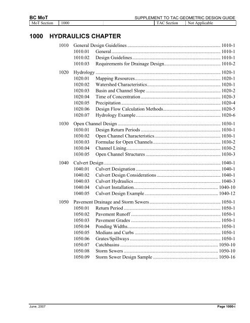
<strong>1000</strong> HYDRAULICS CHAPTER<br />
1010 General Design Guidelines ............................................................................ 1010-1<br />
1010.01 General......................................................................................... 1010-1<br />
1010.02 Design Guidelines........................................................................ 1010-1<br />
1010.03 Requirements for Drainage Design.............................................. 1010-2<br />
1020 Hydrology ...................................................................................................... 1020-1<br />
1020.01 Mapping Resources...................................................................... 1020-1<br />
1020.02 Watershed Characteristics............................................................ 1020-1<br />
1020.03 Basin and Channel Slope ............................................................. 1020-2<br />
1020.04 Time <strong>of</strong> Concentration ................................................................. 1020-3<br />
1020.05 Precipitation ................................................................................. 1020-4<br />
1020.06 Design Flow Calculation Methods............................................... 1020-5<br />
1020.07 Hydrology Example..................................................................... 1020-6<br />
1030 Open Channel Design .................................................................................... 1030-1<br />
1030.01 Design Return Periods ................................................................. 1030-1<br />
1030.02 Open Channel Characteristics...................................................... 1030-1<br />
1030.03 Formulae for Open Channels....................................................... 1030-2<br />
1030.04 Channel Lining............................................................................. 1030-2<br />
1030.05 Open Channel Structures ............................................................. 1030-3<br />
1040 Culvert Design ............................................................................................... 1040-1<br />
1040.01 Culvert Designation ..................................................................... 1040-1<br />
1040.02 Culvert Design Considerations .................................................... 1040-1<br />
1040.03 Culvert <strong>Hydraulics</strong>....................................................................... 1040-3<br />
1040.04 Culvert Installation..................................................................... 1040-10<br />
1040.05 Culvert Design Example............................................................ 1040-12<br />
1050 Pavement Drainage and Storm Sewers.......................................................... 1050-1<br />
1050.01 Return Period ............................................................................... 1050-1<br />
1050.02 Pavement Run<strong>of</strong>f ......................................................................... 1050-1<br />
1050.03 Pavement Grades ......................................................................... 1050-1<br />
1050.04 Ponding Widths............................................................................ 1050-1<br />
1050.05 Medians and Curbs ...................................................................... 1050-1<br />
1050.06 Grates/Spillways .......................................................................... 1050-1<br />
1050.07 Catchbasins ................................................................................ 1050-10<br />
1050.08 Storm Sewers ............................................................................. 1050-10<br />
1050.09 Storm Sewer Design Sample ..................................................... 1050-16<br />
June, 2007 Page <strong>1000</strong>-i
SUPPLEMENT TO TAC GEOMETRIC DESIGN GUIDE<br />
MoT Section <strong>1000</strong> TAC Section Not Applicable<br />
BC MoT<br />
1060 Ditch Infilling................................................................................................. 1060-1<br />
1060.01 General......................................................................................... 1060-1<br />
1060.02 Sizing ........................................................................................... 1060-1<br />
1060.03 Installation.................................................................................... 1060-1<br />
1060.04 Cross Culverts.............................................................................. 1060-1<br />
1060.05 Inlet and Outlet Ditches ............................................................... 1060-2<br />
1060.06 Backfilling.................................................................................... 1060-2<br />
1060.07 Catchbasins .................................................................................. 1060-2<br />
1060.08 Perimeter and Ro<strong>of</strong> Drains........................................................... 1060-2<br />
1060.09 Planting ........................................................................................ 1060-2<br />
1060.10 Traffic Control ............................................................................. 1060-2<br />
Page <strong>1000</strong>-ii June, 2007
BC MoT<br />
SUPPLEMENT TO TAC GEOMETRIC DESIGN GUIDE<br />
MoT Section <strong>1000</strong> TAC Section Not Applicable<br />
<strong>1000</strong> HYDRAULICS CHAPTER<br />
TABLES<br />
1010.A Design Return Periods for Hydraulic Structures (years).................................... 1010-2<br />
1020.A Maximum Run<strong>of</strong>f Coefficient Values for Coastal Type Basins ........................ 1020-2<br />
1040.A Manning’s Roughness Coefficient ..................................................................... 1040-3<br />
1050.A Grate Catchment Widths .................................................................................... 1050-1<br />
1050.B Spillway Catchment Width ................................................................................ 1050-2<br />
1050.C Inlet Spacing Tables for Depressed BC Bicycle Safe Grate .............................. 1050-3<br />
1050.D Inlet Spacing Tables for Depressed BC Freeway Grate..................................... 1050-4<br />
1050.E Inlet Spacing Tables for Undepressed BC Bicycle Safe Grate .......................... 1050-5<br />
1050.I Manhole Spacings ............................................................................................ 1050-10<br />
1050.M Concrete Pipe Trench Installation .................................................................... 1050-15<br />
June, 2007<br />
Page <strong>1000</strong>-iii
SUPPLEMENT TO TAC GEOMETRIC DESIGN GUIDE<br />
MoT Section <strong>1000</strong> TAC Section Not Applicable<br />
BC MoT<br />
<strong>1000</strong> HYDRAULICS CHAPTER<br />
FIGURES<br />
1020.B Time <strong>of</strong> Concentration........................................................................................ 1020-1<br />
1030.A Riprap Design Chart........................................................................................... 1030-4<br />
1040.B Hydraulic Design Chart for Circular Steel Pipe................................................. 1040-5<br />
1040.C Hydraulic Design Chart for Corrugated Steel Pipe-Arch................................... 1040-6<br />
1040.D Hydraulic Sample Chart for Circular Steel Pipe ................................................ 1040-7<br />
1040.E Hydraulic Sample Chart for Corrugated Steel Pipe-Arch.................................. 1040-8<br />
1040.F Inlet Control Nomograph ................................................................................... 1040-9<br />
1040.G Foundation Excavation for Culverts................................................................. 1040-11<br />
1050.F Sample Spreadsheet - Spacing for Depressed/Undepressed<br />
BC Bicycle Safe Grate........................................................................................ 1050-7<br />
1050.G Sample Spreadsheet – Spacing for Depressed/Undepressed<br />
BC Freeway Grate .............................................................................................. 1050-8<br />
1050.H Sample Spreadsheet – Inlet Spacing for Spillways ............................................ 1050-9<br />
1050.J Concrete Pipe Storm Sewer Foundation Excavation ....................................... 1050-12<br />
1050.K Corrugated Steel Pipe Storm Sewer Foundation Excavation........................... 1050-13<br />
1050.L Foundation Excavation Volumes per Metre Depth <strong>of</strong> Manhole ...................... 1050-14<br />
1060.A Ditch Infilling / Culverting................................................................................. 1060-3<br />
Page <strong>1000</strong>-iv June, 2007
BC MoT<br />
SUPPLEMENT TO TAC GEOMETRIC DESIGN GUIDE<br />
MoT Section 1010 TAC Section Not Applicable<br />
1010<br />
GENERAL DESIGN GUIDELINES<br />
1010.01 GENERAL<br />
This chapter has been prepared as a guide to the<br />
acceptable procedures and methods used in the<br />
development <strong>of</strong> hydraulic design plans for the design,<br />
construction and maintenance <strong>of</strong> British Columbia<br />
highways.<br />
It is intended for the use <strong>of</strong> personnel competent to<br />
evaluate the significance and limitations <strong>of</strong> its content and<br />
recommendations, and who will accept responsibility for<br />
the application <strong>of</strong> the material it contains. The <strong>Ministry</strong><br />
<strong>of</strong> <strong>Transportation</strong> disclaims any or all responsibility for<br />
the application <strong>of</strong> the stated guidelines.<br />
This chapter is not intended to be a textbook <strong>of</strong> hydraulic<br />
engineering but a reference book <strong>of</strong> guidelines and<br />
instructions. It does not cover all conceivable problems<br />
that might arise or address all <strong>of</strong> the possible<br />
methodologies. The scope <strong>of</strong> the chapter is limited to<br />
relatively simple hydrology and hydraulics. Advanced or<br />
complicated analyses should be referred first to the<br />
Regional Offices, then to Engineering Branch,<br />
Headquarters.<br />
The chapter is intended to meet BC conditions and design<br />
practices. The chapter is also to be used in conjunction<br />
with the following readings:<br />
• CSPI Handbook <strong>of</strong> Steel Drainage and Highway<br />
Construction Products (2002)<br />
• CSPI Modern Sewer Design (1996)<br />
• Atmospheric Environment Service (AES) Rainfall<br />
Frequency Atlas for Canada (1985, Hogg; Carr) +<br />
• Department <strong>of</strong> Fisheries and Oceans - Land<br />
Development Guidelines for the Protection <strong>of</strong><br />
Aquatic Habitat (1993)<br />
• MoT Standard Specifications for Highway<br />
Construction<br />
• RTAC Drainage Manual Volume 1 (1982) and<br />
Volume 2 (1987)*<br />
+ Copies <strong>of</strong> the atlas are available upon request from Climate<br />
Services at Environment Canada: e-mail:<br />
climate.services@ec.gc.ca<br />
* CD Rom can be purchased from Glen Cole, Manager, Technical<br />
Information Programs, TAC, Tel: (613) 736-1350 Ext 244, Email:<br />
library@tac-atc.ca, or directly from the website. http://www.tacatc.ca/english/projectsandpublications/bookstore.cfm<br />
Updating this chapter is a continuing process and<br />
revisions will be issued as required.<br />
1010.02 DESIGN GUIDELINES<br />
Bridge and Culvert Hydraulic Design<br />
Bridge and large diameter (≥ 3 m) culvert hydraulic<br />
design requires an understanding <strong>of</strong> the complex<br />
relationship between channel morphology, hydrology,<br />
bridge hydraulics, and scour protection and is beyond the<br />
scope <strong>of</strong> this guide. The BC MoT Bridge Standards and<br />
Procedures Manual shall be referenced for bridge<br />
hydrotechnical design and specifically, the hydraulic<br />
design <strong>of</strong> bridges, buried structures, culverts and<br />
associated works shall comply with the requirements <strong>of</strong><br />
the <strong>Transportation</strong> Association <strong>of</strong> Canada (TAC) Guide to<br />
Bridge <strong>Hydraulics</strong>, (latest edition).<br />
Design Flood Return Periods<br />
The design flood return period criteria indicated in Table<br />
1010.A shall be used for the design <strong>of</strong> highway drainage<br />
facilities, culverts and bridges.<br />
The selection <strong>of</strong> the return period for storm sewers,<br />
highway ditches and culverts < 3 m span from the values<br />
specified in the table shall be determined by a<br />
pr<strong>of</strong>essional engineer using risk assessment, general<br />
practice and pr<strong>of</strong>essional judgment.<br />
In some instances, there will be situations when the<br />
degree <strong>of</strong> risk is high enough to justify design return<br />
periods greater than those shown in the table for gutters,<br />
storm water inlets, storm sewers and highway ditches.<br />
Similarly, there will be situations when the degree <strong>of</strong> risk<br />
is low enough to justify smaller return periods.<br />
When using design return periods other than those given<br />
in Table 1010.A, a documented risk assessment must be<br />
completed by a pr<strong>of</strong>essional engineer and approval for the<br />
design return period must be obtained from the Chief<br />
Engineer.<br />
It may also be necessary to design drainage facilities to<br />
conform to the requirements <strong>of</strong> local authorities.<br />
When the upstream flood levels are critical, it may be<br />
necessary to design the hydraulic structure so as not to<br />
increase the upstream water levels. In some instances, it<br />
is important to recognize that the <strong>Ministry</strong> <strong>of</strong><br />
Environment (MoE) uses the 1 in 200 year return period<br />
as a provincial standard to define the floodplain area and<br />
to control development near watercourses.<br />
June, 2007 Page 1010-1
SUPPLEMENT TO TAC GEOMETRIC DESIGN GUIDE<br />
MoT Section 1010 TAC Section Not Applicable<br />
BC MoT<br />
Where fish and fish habitat are involved, it may be<br />
necessary to design the hydraulic structure to meet the<br />
regulatory agencies approval. The designer will find that<br />
the Department <strong>of</strong> Fisheries and Oceans (DFO), Canada<br />
and the <strong>Ministry</strong> <strong>of</strong> Agriculture, Food & Fisheries<br />
(MAFF) are generally the regulatory agencies.<br />
Table 1010.A - Design Return Periods for Hydraulic Structures (years)<br />
1<br />
2<br />
Road Classification Low Volume Local Collector Arterial Freeway<br />
Hydraulic Structures<br />
Gutters - 5 5 5 5<br />
Stormwater Inlets - 5 5 5 5<br />
Storm Sewers - 10 to 25 10 to 25 10 to 25 10 to 25<br />
Highway Ditches 10 to 25 10 to 25 10 to 25 10 to 25 10 to 25<br />
Culverts < 3 m Span 1 50 to 100 50 to 100 100 100 100<br />
Buried Structures &<br />
Culverts ≥ 3 m Span 2 100 200 200 200 200<br />
Bridges 2 100 200 200 200 200<br />
River Training and<br />
Channel Control Works<br />
100 200 200 200 200<br />
For drainage areas less than 1 ha, the 10-year return period storm can be used.<br />
Design shall be in accordance with BC MoT Bridge Standards and Procedures Manual<br />
1010.03 REQUIREMENTS FOR<br />
DRAINAGE DESIGNS<br />
Land Development Drainage Design<br />
Dual Drainage Concept<br />
All drainage works shall be designed utilizing the dual<br />
drainage or minor/major system concept.<br />
The minor or piped system consists primarily <strong>of</strong> the storm<br />
sewer system comprised <strong>of</strong> inlets, conduits, manholes and<br />
other appurtenances designed to collect and discharge<br />
into a major system for frequently occurring storms (e.g.<br />
less than 5 to 10 year return period).<br />
The major or overland system will come into operation<br />
once the minor system’s capacity is exceeded. Thus, in<br />
developments where the major system has been planned,<br />
the streets and ditches may act as open channels directing<br />
the excess storm water to nearby watercourses without<br />
endangering the public, damaging property or causing<br />
excessive erosion. The major system shall be designed to<br />
convey a 100 year return period peak discharge.<br />
For information on the dual drainage system, refer to:<br />
♦ CSPI Modern Sewer Design (1996), p. 139.<br />
Discharge Rates for Land Development<br />
All drainage systems must include run-<strong>of</strong>f controls to<br />
limit post-development peak discharge rates to the predevelopment<br />
rates for 5 year return period storms.<br />
An additional <strong>Ministry</strong> requirement is an assessment <strong>of</strong><br />
the receiving ditch or watercourse for peak flows greater<br />
than a 5 year return period up to a 100 year return period.<br />
The assessment must document the net change in water<br />
velocity in the ditch or receiving water, identify any<br />
potential impacts from increased peak flows, and make<br />
recommendations for mitigation. In other words, flows<br />
must be managed to ensure that no increase in flooding<br />
and stream erosion occur as a result <strong>of</strong> development storm<br />
drainage.<br />
For information on Storm Drainage Design refer to:<br />
♦<br />
♦<br />
♦<br />
Master Municipal Construction Document (MMCD)<br />
Design Guideline Manual (2005)<br />
Stormwater Planning, A Guidebook for British<br />
Columbia<br />
Water Balance Model for British Columbia<br />
Page 1010-2 June, 2007
BC MoT<br />
SUPPLEMENT TO TAC GEOMETRIC DESIGN GUIDE<br />
MoT Section 1010 TAC Section Not Applicable<br />
Water Quality<br />
Run-<strong>of</strong>f quality treatment for highway or land<br />
development drainage is good practice, and is <strong>of</strong>ten<br />
mandated by Federal, Provincial or Regional guidelines<br />
or permits. Design considerations include: using catch<br />
basins to direct pavement run-<strong>of</strong>f overland instead <strong>of</strong><br />
direct discharge to streams, topsoil and sod lined ditches,<br />
filtration ditch blocks, and/or water quality ponds at ditch<br />
outlets to streams. A Registered Pr<strong>of</strong>essional Biologist<br />
shall be involved with these designs.<br />
Reports for Land Development Drainage<br />
The <strong>Ministry</strong> recommends all Subdivision Development<br />
Drainage Reports contain the following information prior<br />
to submission:<br />
• existing and proposed site description.<br />
• site hydrology and hydraulic calculations including:<br />
• pre and post-development flows, return<br />
periods and contributing drainage areas;<br />
• design storm details or continuous<br />
simulation details;<br />
• a table showing the run-<strong>of</strong>f and ditch<br />
capacity calculations;<br />
• detention/retention and other flow control<br />
requirements.<br />
• plans/drawings including:<br />
• site plan with contours and scale noted;<br />
• existing plan with contours and the layout<br />
and identification <strong>of</strong> the existing system<br />
including roads, watercourses, major flow<br />
paths, storm sewers, catchbasins, culverts,<br />
ditches, etc.;<br />
• developed site plan with the layout and<br />
identification <strong>of</strong> the proposed drainage<br />
system including proposed land uses, lot<br />
grading, roads, storm sewers, catchbasins,<br />
culverts, ditches, etc.<br />
• if necessary, a discussion <strong>of</strong> need for and design <strong>of</strong><br />
special features such as detention, erosion and<br />
sediment control, water quality improvement ponds,<br />
lined channels, inlet/outlet structures, groundwater<br />
control, etc.<br />
• listing <strong>of</strong> problem areas and/or unresolved issues<br />
with recommended course <strong>of</strong> action.<br />
Detention Storage and Run-<strong>of</strong>f Controls<br />
Proposed works for a development should be designed<br />
using the following criteria:<br />
• an increase in downstream flooding or stream erosion<br />
will not be allowed. Designs will achieve this<br />
requirement unless it can be demonstrated that these<br />
changes do not adversely impact property or the<br />
environment;<br />
• a hydrograph method shall be used to calculate<br />
design run-<strong>of</strong>f volumes;<br />
• storage requirements must be checked for a number<br />
<strong>of</strong> storm durations to confirm the maximum storage<br />
requirements. (Storm durations that generate the<br />
critical peak flow may be different from the duration<br />
that generates the critical storage volume);<br />
• 24 hour duration rainfall should be checked for<br />
coastal areas;<br />
• alternatively, continuous simulations may be used in<br />
place <strong>of</strong> design storms for sizing storage volumes and<br />
assessing stream impacts;<br />
• the detention ponds should be designed to reduce all<br />
post-development discharge rates up to the 5-year<br />
return period to the corresponding pre-development<br />
rates;<br />
• un-attenuated flood waters in excess <strong>of</strong> the 5 year<br />
discharge that by-pass the detention facility must not<br />
adversely affect the receiving ditch or channel.<br />
Documentation <strong>of</strong> this assessment is required for all<br />
projects.<br />
• an unconfined emergency spillway capable <strong>of</strong><br />
passing a 100 year peak discharge should be<br />
provided to direct overflow safely into the<br />
downstream watercourse.<br />
In areas where a Master Drainage Plan has been<br />
developed, all subsequent drainage designs should<br />
conform to the plan.<br />
The Subdivision Development Drainage Report must<br />
provide sufficient information to allow the reviewer to<br />
understand the developer’s objectives and to thoroughly<br />
assess the hydraulic impacts <strong>of</strong> the development.<br />
For information on Storm Drainage Design refer to:<br />
♦<br />
♦<br />
♦<br />
Master Municipal Construction Document (MMCD)<br />
Design Guideline Manual (2005)<br />
Stormwater Planning, A Guidebook for British<br />
Columbia<br />
Water Balance Model for British Columbia<br />
June, 2007 Page 1010-3
BC MoT<br />
SUPPLEMENT TO TAC GEOMETRIC DESIGN GUIDE<br />
MoT Section 1010 TAC Section Not Applicable<br />
Highway Drainage Design<br />
Channel and Culvert Pr<strong>of</strong>iles<br />
Channel pr<strong>of</strong>iles are required to determine the design<br />
hydraulic gradient and critical hydraulic controls and it is<br />
good practice to prepare culvert pr<strong>of</strong>iles in the drainage<br />
details <strong>of</strong> the design drawing set. These pr<strong>of</strong>iles will help<br />
to develop ditch, channel and culvert design features such<br />
as: adequate depth <strong>of</strong> coverage for structural pipe design;<br />
clearances to utilities or walls; the excavation depth; the<br />
rock horizon for culvert trenching; traffic management<br />
around proposed excavations; culvert extension<br />
components; roadside safety end treatments; fish passage;<br />
upstream trash racks and debris flow protection; erosion<br />
protection for the outlet velocities and soil type to avoid<br />
erosion; and energy dissipation provided where needed.<br />
The length <strong>of</strong> the pr<strong>of</strong>ile survey upstream and<br />
downstream <strong>of</strong> a structure should be 10 to 20 bankfull<br />
channel widths or 150 m, whichever is greater.<br />
Reports for Highway Drainage<br />
Highway drainage design reports are required for small<br />
culverts (< 3 m diameter), pavement drainage and storm<br />
sewer design, and ditch in-filling. The report should<br />
include most information as noted above in “Reports for<br />
Land Development Drainage” and also:<br />
• photos <strong>of</strong> existing culverts;<br />
• a topographic map showing the run-<strong>of</strong>f catchment<br />
areas with numbered culverts or drainage<br />
outlets/crossings;<br />
• an inventory <strong>of</strong> culverts and water channels <strong>of</strong>f the<br />
highway alignment and shown on the drawings,<br />
along with their interconnection to the proposed<br />
highway culvert system.<br />
Page 1010-4 June, 2007
BC MoT<br />
SUPPLEMENT TO TAC GEOMETRIC DESIGN GUIDE<br />
MoT Section 1020 TAC Section 2.1.2<br />
1020<br />
HYDROLOGY<br />
1020.01 MAPPING RESOURCES<br />
Topographic Mapping<br />
Many rural and urban areas have 1:5000 or 1:<strong>1000</strong>0<br />
topographic mapping with 2 m and 10 m contour<br />
intervals. TRIM mapping at 1:20000 and 20 m contour<br />
intervals, prepared by Base Mapping and Geomatic<br />
Services, <strong>Ministry</strong> <strong>of</strong> Sustainable Resource Management<br />
(MSRM),, are available in digital files or as paper prints.<br />
National Topographic Series (NTS) mapping at scales <strong>of</strong><br />
1:50000 and 1:250000 are also available.<br />
Site inspections and air photo interpretation should also<br />
be used wherever possible.<br />
For information on :<br />
♦ Air Photos – contact Base Mapping and Geomatic<br />
Services, MSRM . See<br />
http://srmwww.gov.bc.ca/bmgs/<br />
♦ Topographical and Trim Maps – contact Crown<br />
Publications Inc., Victoria, BC. See<br />
http://www.crownpub.bc.ca/<br />
Floodplain Mapping<br />
Floodplain maps are available for over one hundred<br />
locations throughout the Province and show the area<br />
affected by the 200-year flood. The maps are generally<br />
drawn to a scale <strong>of</strong> 1:5000 with one meter contour<br />
intervals. The maps also show natural and man-made<br />
features <strong>of</strong> the area.<br />
For information on:<br />
♦ Available Floodplain Maps – see<br />
http://srmwww.gov.bc.ca/aib/fpm/index.html#How<br />
♦ Purchase <strong>of</strong> Floodplain Maps – See<br />
http://www.crownpub.bc.ca/<br />
1020.02 WATERSHED<br />
CHARACTERISTICS<br />
Drainage Area<br />
The drainage area should be determined from contour<br />
maps assuming that water will flow at right angles to the<br />
contours. The influences <strong>of</strong> ditches and roads must be<br />
taken into account as well as other features that could<br />
divert run<strong>of</strong>f from the natural run<strong>of</strong>f channels shown by<br />
the contours. The drainage area is usually expressed in<br />
units <strong>of</strong> hectares (ha) or square kilometres (km 2 ).<br />
Land Use<br />
Official Settlement Plans, which may consider up to 20<br />
years <strong>of</strong> future planning, are available from the Regional<br />
Districts.<br />
Baseline Thematic mapping showing present land use at a<br />
scale <strong>of</strong> 1:250,000 is available in paper or digital format.<br />
For information on Baseline Thematic mapping, contact:<br />
♦ Base Mapping and Geomatic Services, MSRM.<br />
Run<strong>of</strong>f Coefficients<br />
In selecting the run<strong>of</strong>f coefficients (C), the land should be<br />
considered to be developed to the limit <strong>of</strong> its zoning. For<br />
smaller drainage areas, detailed land use information may<br />
be available resulting in a more precise estimate <strong>of</strong> the<br />
run<strong>of</strong>f coefficients. With larger drainage basins only<br />
general information is usually available resulting in the<br />
need to use conservative assumptions <strong>of</strong> the run<strong>of</strong>f<br />
coefficients.<br />
Table 1020.A was obtained from the MSRM, Resource<br />
Information Branch, Hydrology Programs and Standards<br />
and presents conservative C values for coastal type<br />
drainage basins where the maximum run<strong>of</strong>f occurs as a<br />
result <strong>of</strong> fall and winter rains.<br />
June, 2007 Page 1020-1
SUPPLEMENT TO TAC GEOMETRIC DESIGN GUIDE<br />
MoT Section 1020 TAC Section Not Applicable<br />
BC MoT<br />
Table 1020.A Maximum Run<strong>of</strong>f Coefficient Values For Coastal Type Basins<br />
Surface Cover Impermeable Forested Agricultural Rural Urban<br />
Physiography<br />
mountain (>30%) 1.00 0.90 - - -<br />
steep slope (20-30%) 0.95 0.80 - - -<br />
moderate slope (10-20%) 0.90 0.65 0.50 0.75 0.85<br />
rolling terrain (5-10%) 0.85 0.50 0.40 0.65 0.80<br />
flat ( 25 years +0.10 +0.05 +0.15 +0.10 +0.10<br />
snowmelt +0.10 +0.10 +0.10 +0.10 +0.10<br />
For small interior drainage basins where the critical<br />
run<strong>of</strong>f events are generally a result <strong>of</strong> summer rainstorms,<br />
the run<strong>of</strong>f coefficients can be selected from the following:<br />
• RTAC Drainage Manual Volume 1 (1982), Table<br />
2.4.1-2.4.3, p. 2.22.<br />
For information on run<strong>of</strong>f coefficients, refer to:<br />
♦ RTAC Drainage Manual Volume 1 (1982), p. 2.22.<br />
SCS Soil Groups and Curve Numbers<br />
Hydrologic soil groups and soil/land use curve numbers<br />
(CN) can be obtained from the following:<br />
• <strong>Ministry</strong> <strong>of</strong> Environmnet (MoE) Soils Maps<br />
• textural classifications provided by geotechnical<br />
investigations<br />
• CSPI Modern Sewer Design (1996), p. 67<br />
• CSPI Handbook <strong>of</strong> Steel and Highway Drainage<br />
Products (2002), p.109.<br />
In areas where flooding is usually the result <strong>of</strong> winter<br />
precipitation (e.g. coastal areas), curve numbers should<br />
generally correspond to Antecedent Moisture Condition<br />
III (AMC III) to reflect the highest run<strong>of</strong>f potential. In<br />
areas where critical run<strong>of</strong>f values are the result <strong>of</strong> summer<br />
storms (e.g. interior areas), Antecedent Moisture<br />
Condition II should be assumed.<br />
For information on SCS soil groups and curve numbers,<br />
refer to:<br />
♦<br />
♦<br />
CSPI Modern Sewer Design (1996), p. 68 &69.<br />
CSPI Handbook <strong>of</strong> Steel Drainage and Highway<br />
Construction Products (2002),p. 108.<br />
1020.03 BASIN AND CHANNEL SLOPE<br />
For small drainage areas, the slope <strong>of</strong> the drainage area<br />
can be estimated using the following formula:<br />
h1 − h2<br />
s =<br />
L<br />
s is the average slope <strong>of</strong> drainage area, m/m<br />
h 1 is the maximum elevation <strong>of</strong> drainage basin, m<br />
h 2 is the minimum elevation <strong>of</strong> drainage basin, m<br />
L is the maximum length <strong>of</strong> drainage path, m<br />
Vertical drops such as falls and rapids, etc. should be<br />
deducted from the calculations.<br />
For large or complex drainage areas, the main channel<br />
slope should be estimated using the Average Slope<br />
Method or the Equivalent Slope Method.<br />
Average Slope Method<br />
The Average Slope Method is recommended for normal<br />
use. It should give reasonable results for streams having<br />
short rapids or falls. However, it is not recommended for<br />
pr<strong>of</strong>iles which are strongly convex or concave for much<br />
<strong>of</strong> their length.<br />
For information on the Average Slope Method, refer to:<br />
♦ RTAC Drainage Manual Volume 1 (1982), p. 2.11.<br />
Page 1020-2 June, 2007
BC MoT<br />
SUPPLEMENT TO TAC GEOMETRIC DESIGN GUIDE<br />
MoT Section 1020 TAC Section 2.1.2<br />
Equivalent Slope Method<br />
The Equivalent Slope Method is recommended for<br />
streams which have intermediate steep sections totaling<br />
over 10 percent <strong>of</strong> the overall length.<br />
For information on the Equivalent Slope Method, refer to:<br />
♦ RTAC Drainage Manual Volume 1 (1982), p. 2.13.<br />
1020.04 TIME OF CONCENTRATION<br />
For most drainage basins (e.g. those not effected by<br />
retention or detention), the “time <strong>of</strong> concentration” is<br />
defined as the time required for the surface run<strong>of</strong>f from<br />
the most remote part <strong>of</strong> the drainage basin to reach the<br />
point <strong>of</strong> concentration being considered. For very small<br />
basins, the following minimum times <strong>of</strong> concentration are<br />
recommended:<br />
urban<br />
5 minutes<br />
residential<br />
10 minutes<br />
natural, undeveloped 15 minutes<br />
Water Management Method<br />
This method was developed by the <strong>Ministry</strong> <strong>of</strong><br />
Environment, Water Management Division, Hydrology<br />
Section and is shown in Figure 1020.B. This method is<br />
limited to drainage areas up to 10 km 2 when used with the<br />
BC Rational Formula and for drainage areas up to 25 km 2<br />
for the SCS Unit Hydrograph Method. The time <strong>of</strong><br />
concentration is dependent on the basin characteristics.<br />
The following parameters should be considered:<br />
flat approximately 0% slope<br />
rolling approximately 1% slope<br />
moderate approximately 2.5% slope<br />
steep greater than 10% slope<br />
For agricultural and rural basins, the curves labeled flat<br />
and rolling should be used. For forested watersheds, the<br />
curves labeled rolling, moderate and steep should be<br />
used.<br />
Figure 1020.B Time <strong>of</strong> Concentration<br />
June, 2007 Page 1020-3
SUPPLEMENT TO TAC GEOMETRIC DESIGN GUIDE<br />
MoT Section 1020 TAC Section Not Applicable<br />
BC MoT<br />
Kirpich Formula<br />
This method can be used to estimate the time <strong>of</strong><br />
concentration for natural basins with well defined<br />
channels, for overland flow on bare earth, and mowed<br />
grassed roadside channels. For overland flow, grassed<br />
surfaces, multiply t c by 2. For overland flow, concrete or<br />
asphalt surfaces, multiply t c by 0.4.<br />
0.77<br />
0.00032 L<br />
t<br />
c<br />
=<br />
0.385<br />
S<br />
t c is the time <strong>of</strong> concentration, hr<br />
L is the total stream length from the most remote part<br />
<strong>of</strong> the basin as extended from the stream source to<br />
the divide, m<br />
S is the average slope <strong>of</strong> the total stream length, m/m<br />
For information on the Kirpich Formula, refer to:<br />
♦ CSPI Handbook <strong>of</strong> Steel Drainage and Highway<br />
Construction Products (2002), p. 116.<br />
Hathaway Formula<br />
This method can be applied to small urban or agricultural<br />
catchments and to small interior basins with light forest.<br />
0.467<br />
(rL)<br />
t<br />
c<br />
=<br />
0.234<br />
1.65 S<br />
t c is the time <strong>of</strong> concentration, hr<br />
L is the total stream length from the most remote part<br />
<strong>of</strong> the basin as extended from the stream source to<br />
the divide, km<br />
S is the average slope <strong>of</strong> the total stream length, m/m<br />
r is the roughness coefficient<br />
The table below presents roughness coefficients which<br />
are recommended for use with the Hathaway formula.<br />
Surface Cover r<br />
smooth, impervious 0.02<br />
smooth, bare packed soil 0.10<br />
poor grass, row crops 0.20<br />
rough, bare soil 0.30<br />
pasture, range land 0.40<br />
deciduous timber land 0.60<br />
coniferous timber land 0.70<br />
timber land with deep litter 0.80<br />
Other Methods<br />
Other methods <strong>of</strong> estimating the time <strong>of</strong> concentration for<br />
small and large watersheds are:<br />
• Uplands Method<br />
• SCS Curve Number Method<br />
• Bransby Williams Formula<br />
Time <strong>of</strong> concentration in channels and conduits can be<br />
estimated using Manning’s Equation, the Continuity<br />
Equation and first principles.<br />
For further information on time <strong>of</strong> concentration and<br />
estimating the time <strong>of</strong> concentration, refer to:<br />
♦ RTAC Drainage Manual Volume 1 (1982), p. 2.23.<br />
♦<br />
CSPI Handbook <strong>of</strong> Steel Drainage and Highway<br />
Construction Products (2002), p. 114.<br />
1020.05 PRECIPITATION<br />
Intensity Duration Frequency Curves<br />
Rainfall intensities can be obtained from Intensity-<br />
Duration-Frequency (IDF) curves which are published by<br />
the Atmosphere Environment Service (AES) for urban<br />
centers in Canada. AES <strong>of</strong>fers s<strong>of</strong>tware and data for<br />
printing and plotting IDF data.<br />
IDF curve data is not recommended in high elevation,<br />
mountainous areas or areas where snowmelt is a<br />
significant contributing factor to flood events.<br />
For general information on IDF curves, refer to:<br />
♦ RTAC Drainage Manual Volume 1 (1982), p. 2.15.<br />
Remote Locations<br />
For remote locations where IDF curves are not available,<br />
the Rainfall Frequency Atlas <strong>of</strong> Canada may provide the<br />
best interpolations <strong>of</strong> extreme rainfall statistics in BC.<br />
Design Storm<br />
A design storm or rainfall pattern, rather than a single<br />
point from IDF values, is required for many unit<br />
hydrograph methods and simulation models. The design<br />
storm pattern may be either historical (e.g. as actually<br />
recorded) or synthetic (e.g. as recreated from statistical<br />
summaries).<br />
Page 1020-4 June, 2007
BC MoT<br />
SUPPLEMENT TO TAC GEOMETRIC DESIGN GUIDE<br />
MoT Section 1020 TAC Section 2.1.2<br />
Research has shown that the SCS Type 1A, 24 hour<br />
rainfall distribution best represents conditions for coastal<br />
BC.<br />
Synthetic design storms can be incorporated into the<br />
following methods to produce design hydrographs:<br />
• BC Rational Formula Method<br />
• SCS Curve Number Method<br />
• SCS Triangular Hydrograph Method<br />
For information on design storms, refer to:<br />
♦ RTAC Drainage Manual Volume 1 (1982), p. 2.19.<br />
1020.06 DESIGN FLOW CALCULATION<br />
METHODS<br />
Small Drainage Areas<br />
For urban and small drainage areas (25 km 2 ), the recommended<br />
design flow calculation methods are:<br />
• Station Frequency Analysis<br />
• Regional Frequency Analysis<br />
For the above noted calculation methods, the most<br />
commonly used distributions to describe extreme flows in<br />
BC are:<br />
• Extreme Value Type 1 (Gumbel)<br />
• Three Parameter Lognormal<br />
• Log Pearson Type III<br />
Annual peak daily and peak instantaneous flows are<br />
available from Water Survey <strong>of</strong> Canada (WSC) gauging<br />
stations.<br />
For information on Station Frequency Analysis and<br />
Regional Frequency Analysis, refer to:<br />
♦ RTAC Drainage Manual Volume 1 (1982), p. 2.31, p.<br />
2.35.<br />
Design flow estimates can also be confirmed using the<br />
following methods:<br />
• FLOOD - UBC, Civil Engineering Department<br />
• Consolidated Frequency Analysis (CFA_3.1)<br />
• Pre-Analyzed Basins - Resource Information Branch,<br />
MSRM.<br />
Design Flow Estimate<br />
In some instances, more than one design flow calculation<br />
method should be used. The designer should evaluate all<br />
the results and finally estimate a design flow based on the<br />
reliability <strong>of</strong> input data, past events, historic high flow<br />
records and experience.<br />
If the drainage areas approach the upper limits, efforts<br />
should be made to check the results using other methods<br />
(e.g. measured flow data, regional frequency analysis<br />
etc.) and confirmed with an on-site inspection <strong>of</strong> stream<br />
channel capacity.<br />
June, 2007 Page 1020-5
SUPPLEMENT TO TAC GEOMETRIC DESIGN GUIDE<br />
MoT Section 1020 TAC Section Not Applicable<br />
BC MoT<br />
1020.07 HYDROLOGY EXAMPLE<br />
Background<br />
Thames Creek is located on the east<br />
side <strong>of</strong> Vancouver Island near<br />
Denman Island.<br />
Problem<br />
Since the highway crosses Thames<br />
Creek, a bridge or culvert will be<br />
required. Estimate the 200-year<br />
(Q 200 ) flow.<br />
Solution<br />
Step 1 - Determine Basin Size and Creek Length<br />
From the 1:50000 scale mapping, the following<br />
dimensions were measured:<br />
A = 6.6 km 2 = 660 ha<br />
L = 8.2 km<br />
Step 2 - Determine Basin Slope<br />
A pr<strong>of</strong>ile <strong>of</strong> the main channel was plotted. Since the<br />
upper portion <strong>of</strong> basin is steep, the basin slope was<br />
estimated using the Equivalent Slope Method.<br />
s = 0.051 m/m = 5.1%<br />
Step 3 - Determine Land Characteristics<br />
Design flows are estimated assuming worst case<br />
conditions. Considerations include basin slope, type <strong>of</strong><br />
vegetation, recurrence intervals, snowmelt, antecedent<br />
moisture condition (AMC) etc. Since the Thames Creek<br />
basin is relatively low with light forest cover, the<br />
following land characteristic values were selected:<br />
r = 0.60, deciduous timber land<br />
CN = 85, forest land with good cover, Hydrologic<br />
Soil Group C, AMC III<br />
C = 0.40, flat, forested<br />
Step 4 - Determine Time <strong>of</strong> Concentration<br />
There are numerous ways <strong>of</strong> estimating the time <strong>of</strong><br />
concentration (t c ). A few different methods will be used<br />
and an “average” value will be selected.<br />
Method 1 - BC Rational Formula Method<br />
A = 66 . km = 2.6km<br />
t c = 3.6hr (interpolated)<br />
2<br />
Method 2 - Hathaway Formula<br />
t = (rL) 0.467 0.467<br />
(( 0. 60)(8.<br />
2km))<br />
c<br />
= = 2.6hr<br />
0234 .<br />
0.234<br />
165 . s 1. 65( 0.<br />
051m/m)<br />
Method 3 - SCS Curve Number Method<br />
S = 254( 100<br />
CN − 1) = 254( 100 − 1)<br />
= 44.8<br />
CN<br />
85<br />
0.8<br />
0.7<br />
T = L ( 0.<br />
039SCN<br />
+1)<br />
L<br />
0.5<br />
735 s<br />
0.8<br />
( 8200m)<br />
( 0. 039( 44.8) + 1)<br />
=<br />
05 .<br />
735(.<br />
51%)<br />
t c = 1.7T L = 1.7(1.7hr) = 2.8hr<br />
07 .<br />
= 17 . hr<br />
Method 4 - Bransby Williams Formula<br />
t = 0.605L 0605 . ( 82 . km)<br />
c = = 30 . hr<br />
0.2 0.1 0.2 2 01 .<br />
s A (5.1%) ( 66 . km )<br />
Taking an “average”, it is assumed that t c =3 hours.<br />
Page 1020-6 June, 2007
BC MoT<br />
SUPPLEMENT TO TAC GEOMETRIC DESIGN GUIDE<br />
MoT Section 1020 TAC Section 2.1.2<br />
Step 5 - Determine Rainfall Intensity<br />
The nearest rainfall gauging station is located at Comox<br />
Airport (El. 24 m). Since the basin elevation varies from<br />
El. 20 m to El. 760 m, a precipitation gradient is<br />
expected. The 10-year rainfall intensity corresponding to<br />
the time <strong>of</strong> concentration will be used due to the increased<br />
reliability <strong>of</strong> rainfall data over more frequent return<br />
periods (e.g. 2-year). A previous hydrological study<br />
estimated the average intensity over the basin will<br />
increase at a rate <strong>of</strong> 5% per 100 m rise in elevation.<br />
i = (9mm / hr)(( 740m )( 05 . )( 005 . ) + 1) = 107 . mm / hr<br />
100m<br />
Step 6 - Determine Design Flow<br />
There are numerous ways <strong>of</strong> estimating the design flow.<br />
A few different methods will be used.<br />
Method 1 - Rational Formula<br />
Since the basin is small and there is limited data, the<br />
Rational Formula will be used to determine the 10-year<br />
flow. The 10-year flow will then be converted to a 200-<br />
year flow. Studies have shown that the Q 200 /Q 10 ratio is<br />
approximately 1.7 for this region.<br />
Method 2 – SCS Peak Flow Method<br />
For this creek, a 24-hour, Type 1A rainfall distribution<br />
will be used in the analysis. The 10-year 24 hour total<br />
rainfall volume will be obtained from the Comox Airport<br />
IDF curve. The estimated 10-year flow will be converted<br />
to a 200-year flow.<br />
Total Rainfall = (3.2mm / hr)(24hr) = 76.8mm<br />
Q 10 = 7.4m 3 / s<br />
3 3<br />
Q 200 = 1.7Q 10 = 1.7(7.4m / s) = 12.6m / s<br />
Method 3 - Regional Frequency Analysis<br />
Hydrological studies have resulted in regional frequency<br />
curves for the area.<br />
Q<br />
200<br />
= (A)(unit run<strong>of</strong>f)(peaking factor)<br />
2 3 2 3<br />
= (6.6km )( 18 . m / skm )( 15 . ) = 17.8m / s<br />
Since the results do not vary significantly, an “average”<br />
will be taken. The 200-year flow is estimated to be 15<br />
m 3 /s.<br />
Q = CiA ( 040)(107 . . mm / hr)(660ha)<br />
10 =<br />
360<br />
360<br />
3<br />
= 7.9m<br />
/ s<br />
3 3<br />
Q 200 = 1.7Q 10 = 1.7(7.9m / s) = 13.4m / s<br />
June, 2007 Page 1020-7
SUPPLEMENT TO TAC GEOMETRIC DESIGN GUIDE<br />
MoT Section 1020 TAC Section Not Applicable<br />
BC MoT<br />
This page<br />
is intentionally left blank<br />
Page 1020-8 June, 2007
BC MoT<br />
SUPPLEMENT TO TAC GEOMETRIC DESIGN GUIDE<br />
MoT Section 1030 TAC Section 2.1.2<br />
1030<br />
OPEN CHANNEL DESIGN<br />
1030.01 DESIGN RETURN PERIODS<br />
For open channel design return periods, refer to<br />
Section 1010.02.<br />
1030.02 OPEN CHANNEL<br />
CHARACTERISTICS<br />
Highway ditch designs typically accommodate right-<strong>of</strong>way<br />
drainage, which may include run<strong>of</strong>f from pavement<br />
areas, cut slopes and adjacent overland flow. Conversely,<br />
drainage channels are specifically designed for larger<br />
drainage basins and watercourses. Drainage channel<br />
design may incorporate the following considerations:<br />
hydraulic requirements, river engineering concepts,<br />
fisheries enhancement works, etc.<br />
For typical earth ditch sections, ditch sections in solid<br />
rock cuts and median sections, refer to:<br />
♦ BC Supplement to TAC Geometric Design Guide,<br />
Fig. 440.A, B, C, D & G.<br />
For geometric properties <strong>of</strong> various open channels, refer<br />
to:<br />
♦ RTAC Drainage Manual Volume 1 (1982), p. 3.4.<br />
Grades<br />
Roadside drainage ditch grades do not necessarily need to<br />
be the same as the road pr<strong>of</strong>ile. The desirable minimum<br />
sustained grade for channels is -0.5%, with -0.3% allowed<br />
as an absolute minimum to ensure drainage and prevent<br />
“standing water”. Steep channel grades should be<br />
checked for erodibility.<br />
For information on ditch grades, refer to:<br />
♦ RTAC Drainage Manual Volume 1 (1982), p. 3.31.<br />
Channel Depth<br />
The roadside drainage ditch depth should be designed<br />
such that the ditch invert is a minimum 0.30 m below the<br />
bottom <strong>of</strong> the SGSB layer. The ditch should also be<br />
designed such that the flow does not frequently make<br />
contact with the SGSB layer. The maximum allowable<br />
depth <strong>of</strong> flow in minor ditches is 0.6 m.<br />
The recommended minimum freeboard is 0.3 m for small<br />
drainage channels, larger channels should have a greater<br />
freeboard allowance.<br />
For information on ditch depth, refer to:<br />
♦ RTAC Drainage Manual Volume 1 (1982), p. 3.31.<br />
Channel Width<br />
The bottom width <strong>of</strong> highway ditches varies and is<br />
dependent upon ditch shape, depth, slope, type <strong>of</strong> material<br />
and maintenance requirements. The bottom width <strong>of</strong> a<br />
roadside ditch should not normally be less than 1 m.<br />
However, for major roadways, this may be increased for<br />
safety purposes to approximately 2 m.<br />
For information on channel width, refer to:<br />
♦ RTAC Drainage Manual Volume 1(1982), p. 3.31.<br />
Sideslopes<br />
Typical channel sideslopes range between 1.5:1 (H:V) to<br />
4:1. Ditch sideslopes steeper than 2:1 are generally<br />
difficult to maintain.<br />
For information on sideslopes, refer to:<br />
♦ BC Supplement to TAC Geometric Design Guide,<br />
Fig. 440.A, B, C, D & G.<br />
Roughness Coefficients<br />
Manning’s roughness coefficients (n) are commonly used<br />
to describe channel and conduit characteristics.<br />
For Manning’s roughness coefficients, refer to:<br />
♦ RTAC Drainage Manual Volume 1 (1982), Table<br />
3.2.3, p. 3.12.<br />
For information on Manning’s roughness coefficients,<br />
refer to:<br />
♦ RTAC Drainage Manual Volume 1 (1982), p. 3.10.<br />
Assessment <strong>of</strong> Existing Channel<br />
An existing channel should be analyzed to determine if<br />
there is sufficient capacity to accommodate the design<br />
flow. If channel capacity is insufficient, drainage<br />
problems may occur at unexpected locations during large<br />
flood events. In addition, channel stability and debris<br />
loads should also be assessed.<br />
June, 2007 Page 1030-1
SUPPLEMENT TO TAC GEOMETRIC DESIGN GUIDE<br />
MoT Section 1030 TAC Section Not Applicable<br />
BC MoT<br />
1030.03 FORMULAE FOR<br />
OPEN CHANNELS<br />
Manual Calculations<br />
Capacity, discharge, depth <strong>of</strong> flow and velocity for<br />
uniform and non-uniform sections such as conduits and<br />
channels can be approximated through an iterative<br />
process involving Manning’s Equation and the Continuity<br />
Equation. A water surface pr<strong>of</strong>ile can be approximated<br />
and is dependent on whether the flow depth, as<br />
determined by Manning’s Equation, is greater or less than<br />
the critical flow depth for the channel.<br />
The Manning’s Equation is as follows:<br />
0.67 0.5<br />
R S<br />
v =<br />
n<br />
v is the average flow velocity, m/s<br />
R is the hydraulic radius = A/P, m<br />
A is the cross sectional area <strong>of</strong> flow, m 2<br />
P is the wetted perimeter, m<br />
S is the friction or channel slope, m/m<br />
n is the Manning’s roughness coefficient<br />
For information on Manning’s Equation, refer to:<br />
♦ RTAC Drainage Manual Volume 1 (1982), p. 3.10.<br />
The Continuity Equation is as follows:<br />
Q = vA<br />
Q is the discharge, m 3 /s<br />
v is the average flow velocity, m/s<br />
A is the cross sectional area <strong>of</strong> flow, m 2<br />
For information on the Continuity Equation, refer to:<br />
♦ RTAC Drainage Manual Volume 1 (1982), p. 3.3.<br />
Critical Flow<br />
Subcritical flow occurs on mild slopes while supercritical<br />
flow occurs on steep slopes. The Froude number (F) will<br />
determine whether the flow is subcritical (F1). The Froude number formula<br />
is as follows:<br />
F=<br />
v<br />
gy h<br />
F is the Froude number<br />
v is the average flow velocity, m/s<br />
g is the gravitational acceleration, m/s 2<br />
y h is the hydraulic depth = A/B, m<br />
A is the cross sectional area <strong>of</strong> flow, m 2<br />
B is the width <strong>of</strong> flow at the water surface, m<br />
For information on critical flow, refer to:<br />
♦ RTAC Drainage Manual Volume 1 (1982), p. 3.5.<br />
Water Surface Pr<strong>of</strong>iles<br />
Natural river channels tend to be highly irregular in shape<br />
so a simple analysis using Manning’s equation, while<br />
helpful for making an approximation, is not sufficiently<br />
accurate to determine a river water surface pr<strong>of</strong>ile. The<br />
following one-dimensional analysis programs are<br />
recommended:<br />
♦ HEC-2<br />
♦ HEC-RAS<br />
The above numerical models have been developed by the<br />
US Army Corps <strong>of</strong> Engineers. Use your internet web<br />
browser to search for “Hec-Ras” and “Hec-2”.<br />
For information on water surface pr<strong>of</strong>iles, refer to:<br />
♦ RTAC Drainage Manual Volume 1 (1982), p. 3.15.<br />
1030.04 CHANNEL LINING<br />
A variety <strong>of</strong> channel liners including grass and riprap are<br />
used where channel slopes are steep. If flow velocities<br />
are high, erosion may be a potential problem. The<br />
treatment <strong>of</strong> highway run<strong>of</strong>f may also be necessary.<br />
Where the grade is -1% and steeper, the erodibility <strong>of</strong> the<br />
channel material should be checked against the flow<br />
velocity. Methods used for the design <strong>of</strong> erodible<br />
channels include:<br />
• maximum permissible velocity<br />
• maximum permissible tractive force<br />
For a qualitative evaluation <strong>of</strong> various types <strong>of</strong> channel<br />
lining, refer to:<br />
♦<br />
RTAC Drainage Manual Volume 1(1982), Table<br />
3.3.2, p. 3.25.<br />
Unlined Channels<br />
Unlined channels exist during construction and may be a<br />
potential problem if erodible soils are present.<br />
Temporary ground protection or a sediment control plan<br />
may be required until sufficient vegetation has developed.<br />
Erosion and sediment control structures shall be designed<br />
according to DFO/MoE guidelines.<br />
For competent mean velocities for cohesionless soils,<br />
refer to:<br />
♦ RTAC Drainage Manual Volume 1 (1982),<br />
Figure 3.3.1, p. 3.23.<br />
For information on erosion and sediment control, refer to:<br />
♦ Fisheries and Oceans - Land Development<br />
Guidelines for Protection <strong>of</strong> Aquatic Habitat (1993),<br />
p. 23.<br />
Page 1030-2 June, 2007
BC MoT<br />
SUPPLEMENT TO TAC GEOMETRIC DESIGN GUIDE<br />
MoT Section 1030 TAC Section 2.1.2<br />
Grassed-Lined Channels<br />
All cut and fill slopes are generally seeded. Small grasslined<br />
channels usually require a minimum slope <strong>of</strong> -0.5%<br />
to function properly. Grass-lined channels are generally<br />
sufficient where the treatment <strong>of</strong> highway run<strong>of</strong>f is<br />
required.<br />
For information on grass-lined channels, refer to:<br />
♦ RTAC Drainage Manual Volume 1 (1982), p. 3.24.<br />
Riprap Lining<br />
Riprap is required where channel degradation and erosion<br />
is a concern. For ditches, the riprap will be placed on the<br />
sideslopes to a height <strong>of</strong> at least the design depth <strong>of</strong> the<br />
water. For creeks and larger watercourses, riprap is<br />
usually placed 0.3 m above the design depth <strong>of</strong> water. A<br />
proper toe or key must also be provided at the bottom <strong>of</strong><br />
any riprap bank protection. Riprap classification can be<br />
determined using Figure 1030.A. The gradation <strong>of</strong> riprap<br />
shall conform to Table 205-A <strong>of</strong> the Standard<br />
Specifications for Highway Construction.<br />
For information on riprap lining, refer to:<br />
♦ TAC Guide to Bridge <strong>Hydraulics</strong>, (latest edition)<br />
♦ RTAC Drainage Manual Volume 1 (1982), p. 3.24.<br />
♦<br />
MoE Riprap Design and Construction Guide (March,<br />
2000)<br />
http://www.env.gov.bc.ca/wsd/public_safety/flood/str<br />
uctural.html#riprap<br />
1030.05 OPEN CHANNEL STRUCTURES<br />
The design <strong>of</strong> open channel structures such as weirs and<br />
ditch blocks must address safety issues and also consider<br />
their location relative to the roadway.<br />
Check Dams/Drop Structures<br />
To prevent erosion and degradation <strong>of</strong> the stream beds,<br />
check dams or drop structures may be required in a<br />
channel where the topography is steeper than the desired<br />
channel slope. The structure should be lower in the<br />
middle than the edges (notched), and riprap protection<br />
should be provided to prevent erosion around the bank<br />
ends and undermining <strong>of</strong> the toe.<br />
Ditch Blocks<br />
Where the ditch grade is steeper than -2%, a ditch block<br />
should be located at the lower side <strong>of</strong> the culvert inlet to<br />
provide a sump and direct flows into culvert. Provision<br />
for a sump may require the sacrifice <strong>of</strong> the ditch slope, the<br />
cutslope or the ditch bottom width.<br />
An option for creating a sump is to steepen up the road<br />
fill slope somewhat without varying the back cutslope<br />
location. Ditch blocks may be constructed using concrete<br />
filled sandbags or by using a berm protected with riprap.<br />
Clear Zone requirements preclude the traditional vertical<br />
faced ditch block design. Barrier protection or<br />
traversable ditch blocks may be needed.<br />
Filter Blanket<br />
To protect fine grained bank material (less than 12 mm<br />
diameter) from scour and sloughing, wave action and<br />
groundwater flow from sideslopes, a filter blanket <strong>of</strong><br />
coarse gravel (less than 100 mm diameter) or geotextile<br />
shall be placed between the bank and riprap.<br />
June, 2007 Page 1030-3
BC MoT<br />
SUPPLEMENT TO TAC GEOMETRIC DESIGN GUIDE<br />
MoT Section 1040 TAC Section Not Applicable<br />
1040<br />
CULVERT DESIGN<br />
1040.01 CULVERT DESIGNATION<br />
Dimensions for culverts shall be shown in the following<br />
form for pipes up to 3000 mm diameter and equivalent:<br />
XX m - YYY Ø ZZZ NN WT CC<br />
Where XX is the total length <strong>of</strong> the culvert in metres;<br />
YYY is the Inside Diameter <strong>of</strong> the culvert in millimetres;<br />
ZZZ are the Initials for the Type <strong>of</strong> Culvert, which is<br />
normally:<br />
CSP 68x13 Corrugated Steel Pipe<br />
CSP 125x25 Corrugated Steel Pipe<br />
SPCSP Structural Plate Corrugated Steel Pipe<br />
SPCSPA Structural Plate Corrugated Steel Pipe Arch<br />
SPCSA Structural Plate Corrugated Steel Arch<br />
CONC Concrete Pipe<br />
PVC Poly Vinyl Chloride Pipe<br />
HDPE High Density Polyethylene Pipe<br />
NN is the wall thickness (WT) in millimetres for steel<br />
pipe. The complete information shall be shown on the<br />
plan and pr<strong>of</strong>ile drawings, although showing <strong>of</strong> the WT<br />
on the plan is optional. PVC and HDPE pipes shall have<br />
a minimum stiffness <strong>of</strong> 320 kPa.<br />
CC is the coating type for CSP and mix type for concrete.<br />
PVC and HDPE shall not contain recycled materials.<br />
Typical coating materials are.<br />
Gal Galvanized<br />
AL2 Aluminized Type 2<br />
PL Polymer Laminated<br />
1040.02 CULVERT DESIGN<br />
CONSIDERATIONS<br />
General<br />
This section is intended for buried structures with spans<br />
less than 3000 mm. The Designer shall pay due regard to<br />
empirical methods, manufacturer’s literature and<br />
solutions that have a proven record <strong>of</strong> success for small<br />
diameter culverts.<br />
Specifications for materials, fabrication and construction<br />
<strong>of</strong> buried structures shall be in accordance with MoT<br />
Standard Specifications SS 303 Culverts and SS 320<br />
Corrugated Steel Pipe, where applicable.<br />
Design Return Periods<br />
For culvert design return periods, refer to Table 1010.A.<br />
Examples <strong>of</strong> when various return periods should be used<br />
are as follows:<br />
50 year For low volume roads with<br />
shallow fill in undeveloped areas.<br />
100 year Normal design except when the<br />
conditions stated for the 50 or 200<br />
year return period are applicable.<br />
200 year For highways in areas where<br />
flood damage is critical and where<br />
requested by MoE.<br />
Culvert Locations<br />
Culverts shall be located at existing watercourses, at low<br />
points and where “day lighting” the culvert outlet is<br />
feasible. The culvert must discharge into a natural<br />
watercourse or a properly designed channel that<br />
terminates at a natural watercourse or body <strong>of</strong> water.<br />
Culvert outflows must not be allowed to find their own<br />
route to down slope watercourses. For highway ditches<br />
in cut, culverts are generally spaced every 300 m.<br />
For information on culvert locations, refer to:<br />
♦ RTAC Drainage Manual Volume 2 (1987), p. 4.12.<br />
♦ CSPI Handbook <strong>of</strong> Steel Drainage and Highway<br />
Construction Products (2002), p.193.<br />
Culvert Types<br />
Common culvert types include circular, pipe arch and<br />
rectangular box. Culvert selection will depend on factors<br />
such as availability, material costs, ease <strong>of</strong> installation,<br />
headroom, durability etc.<br />
For information on culvert types, refer to:<br />
♦ RTAC Drainage Manual Volume 2 (1987), p. 4.3.<br />
June, 2007 Page 1040-1
BC MoT<br />
SUPPLEMENT TO TAC GEOMETRIC DESIGN GUIDE<br />
MoT Section 1040 TAC Section Not Applicable<br />
Culvert Size<br />
The following minimum culvert diameters are<br />
recommended:<br />
• The minimum size culvert under a highway or main<br />
road shall be 600 mm diameter.<br />
• The minimum size frontage road culvert shall be 500<br />
mm diameter.<br />
• The minimum size driveway culvert shall be 400 mm<br />
diameter.<br />
Skew<br />
A skew angle shall be designated for all installations.<br />
The skew angle is the angle measured from the centerline<br />
<strong>of</strong> the highway ahead to the centerline <strong>of</strong> the culvert,<br />
measured in a clockwise direction. The normal range is<br />
from 45 to 135 degrees.<br />
A cross culvert from a highway ditch in cut shall be<br />
installed on a skew to facilitate inlet pickup.<br />
For information on culvert skew, refer to:<br />
♦ CSPI Handbook <strong>of</strong> Steel Drainage and Highway<br />
Construction Products (2002), p. 199.<br />
Slope<br />
Culverts should generally be placed on the stream grade.<br />
If possible, culverts should ideally be placed slightly<br />
steeper than the critical slope for the size and type <strong>of</strong> pipe<br />
used. This is usually between 1.0 to 2.2%, however the<br />
desirable minimum gradient is 0.5% to prevent<br />
sedimentation. The desired maximum gradient is 20% for<br />
CSP and 10% for concrete pipes.<br />
For culverts on steep grades, the stability <strong>of</strong> the upstream<br />
bed material should be reviewed to ensure the culvert<br />
invert is not abraded by the bed load. Additional features<br />
including thicker walls, wear resistant coatings, and<br />
armoured and paved inverts should be considered.<br />
For culverts required to provide fish passage, the culvert<br />
slope may have to be less than 0.5% to minimize<br />
velocities. Special culvert enhancements to provide fish<br />
passage may also be considered.<br />
In some instances a culvert may be located at a grade<br />
change in a channel bed (e.g. break point between steep<br />
mountain flow and floodplain flow). This is the worst<br />
place for debris deposition therefore mitigative measures<br />
such as a debris basin or smooth flow transition should be<br />
considered.<br />
For information on culvert slopes, refer to:<br />
♦ CSPI Handbook <strong>of</strong> Steel Drainage and Highway<br />
Construction Products (2002), p.196.<br />
♦ RTAC Drainage Manual Volume 2 (1987), pp. 4.12.<br />
♦ Land Development Guidelines for the Protection <strong>of</strong><br />
Aquatic Habitat (1993), p. 73.<br />
Invert Elevations at Streams<br />
Culvert inverts should be at least one quarter <strong>of</strong> the rise<br />
below the average natural channel bed up to a maximum<br />
depth <strong>of</strong> 1 m. Exceptions to the recommended invert<br />
depth may be considered when site specific features<br />
would require special attention (i.e. fish passage;<br />
bedrock).<br />
Length<br />
Culverts shall extend at least 0.5 to 0.7 m beyond the toe<br />
<strong>of</strong> slope to accommodate possible sloughing. If riprap is<br />
to be placed at the culvert ends, the end extensions should<br />
be adjusted accordingly. The total culvert length shall be<br />
rounded up to the nearest 1.0 m. CSP stock pipe lengths<br />
are 6 m, however, other lengths are available.<br />
For a SPCSP or concrete box culvert, the extension<br />
beyond the toe may be greater than 0.7 m due to the<br />
length <strong>of</strong> the prefabricated sections.<br />
As part <strong>of</strong> final construction clean up, the embankment<br />
shall be built-up around the culvert end to limit protrusion<br />
to less than 150 mm. Culvert ends shall be step-bevelled,<br />
where appropriate.<br />
For information on culvert length, refer to:<br />
♦ CSPI Handbook <strong>of</strong> Steel Drainage and Highway<br />
Construction Products (2002), p. 197.<br />
Wall Thickness and Height <strong>of</strong> Cover Requirements<br />
The Canadian Highway Bridge Design Code (CHBDC)<br />
indicates that the provisions <strong>of</strong> Section 7 <strong>of</strong> the code<br />
apply only to buried structures with span (DH) greater<br />
than 3000 mm, but the CHBDC does not provide design<br />
guidance for smaller structures.<br />
Buried structures with spans less than or equal to 3000<br />
mm may also be designed to CHBDC S6-06 Section 7<br />
(except that the design live load vehicle shall be the BCL-<br />
625 per the BC MoT Supplement to CHBDC S6-06), or<br />
the Designer shall use empirical methods, current practice<br />
and manufacturer’s literature and solutions that have a<br />
proven record <strong>of</strong> success for small diameter culverts.<br />
Maximum and minimum height <strong>of</strong> cover and minimum<br />
wall thickness shall be per manufacturer’s specifications.<br />
CSP wall thickness and height <strong>of</strong> cover are shown in<br />
Tables HC-1 to HC -12 in the following:<br />
♦ CSPI Handbook <strong>of</strong> Steel Drainage and Highway<br />
Construction Products (2002),<br />
SPCSP, concrete pipe, and PVC/HDPE wall thickness<br />
shall be obtained from manufacturer specifications.<br />
Page 1040-2 June, 2007
BC MoT<br />
SUPPLEMENT TO TAC GEOMETRIC DESIGN GUIDE<br />
MoT Section 1040 TAC Section Not Applicable<br />
For culverts less than 3000 mm diameter, a minimum<br />
cover <strong>of</strong> 450 mm (measured from the finished shoulder<br />
grade) over the crown <strong>of</strong> the pipe is required. The<br />
minimum cover requirements may require a sump at the<br />
inlet. An increase in minimum height <strong>of</strong> cover may be<br />
required for heavy construction vehicle loading.<br />
Durability Constraints<br />
If not specified otherwise in a design assignment, the<br />
structural design life <strong>of</strong> a culvert shall be 50 years. The<br />
flow water chemistry is a significant factor relating to the<br />
durability <strong>of</strong> pipe materials; however, economical pipe<br />
materials and coatings are available that perform well in<br />
BC waters. Water hardness, pH and Resistivity values<br />
should be obtained at each site to confirm environmental<br />
conditions. If water resistivity values are 8000<br />
ohm-cm, specialist advice should be obtained. Where<br />
abrasion and corrosion interferes with durability, a<br />
suitable coating or pipe material must be selected. In<br />
some applications, such as creeks with high bed load,<br />
armoured inverts, open bottom arches on concrete<br />
footings or concrete box culverts are recommended.<br />
For information on Durability, refer to:<br />
♦ CSPI Handbook <strong>of</strong> Steel Drainage and Highway<br />
Construction Products (2002), <strong>Chapter</strong> 8;<br />
♦ RTAC Drainage Manual Volume 2 (1987),.<br />
Manning’s Roughness Coefficient<br />
The following roughness coefficients (n) are<br />
recommended for culverts:<br />
Table 1040.A Manning’s Roughness Coefficient<br />
Pipe Material<br />
CSP<br />
SPCSP<br />
Manning’s “n”<br />
Varies<br />
~ 0.021 to 0.027<br />
Varies<br />
~ 0.027 to 0.033<br />
concrete 0.012<br />
PVC 0.009<br />
For CSP and SPCSP, the roughness coefficient will<br />
depend on the depth <strong>of</strong> flow, pipe material, corrugation<br />
dimensions and whether the pipe is annular or helical.<br />
The above Manning’s roughness coefficients can be<br />
confirmed from:<br />
• RTAC Drainage Manual Volume 1 (1982), Table<br />
3.2.3, p. 3.12.<br />
• CSPI Handbook <strong>of</strong> Steel Drainage and Highway<br />
Construction Products (2002), Table 4-6, 4-7, p. 145,<br />
p. 146.<br />
1040.03 CULVERT HYDRAULICS<br />
The following design criteria are recommended for<br />
typical culverts:<br />
• Inlet control headwater depth to diameter ratio<br />
(HW/D) shall not exceed 1.0 at the design flow.<br />
• Outlet control headloss through a typical highway<br />
culvert shall be less than 0.3 m.<br />
The minimum pipe gradient for inlet control and initial<br />
dimensions for circular steel pipe and steel pipe arch<br />
culverts can be determined using Figure 1040.B and<br />
Figure 1040.C respectively. A worked example for<br />
circular pipe is provided in Figure 1040.D and pipe-arch<br />
in Figure 1040.E.<br />
The culvert operation must be checked for inlet and outlet<br />
control. The greater headwater depth (HW) will govern.<br />
For information on culvert design procedures, refer to:<br />
♦ RTAC Drainage Manual Volume 2 (1987), p. 4.35.<br />
Culverts providing fish passage shall be designed with<br />
reference to the Land Development Guidelines.<br />
For information on fish passage requirements, refer to:<br />
♦ Land Development Guidelines for the Protection <strong>of</strong><br />
Aquatic Habitat (1993), p. 69.<br />
♦ RTAC Drainage Manual Volume 2 (1987), p. 4.107.<br />
♦ CSPI Handbook <strong>of</strong> Steel Drainage and Highway<br />
Construction Products (2002), p.9.<br />
Check For Inlet Control<br />
Headwater depths under inlet control (HW in ) can be<br />
estimated using the following figures:<br />
For circular CSP and SPCSP:<br />
• CSPI Handbook <strong>of</strong> Steel Drainage and Highway<br />
Construction Products (2002), Figure 4-10, p. 151.<br />
A frequently used inlet control nomograph for circular<br />
pipes is presented in Figure 1040.F.<br />
For CSP and SPCSP pipe arch:<br />
• CSPI Handbook <strong>of</strong> Steel Drainage and Highway<br />
Construction Products (2002), Figure 4-12, 4-13, 4-<br />
14, p. 153, p.154, p. 155.<br />
For circular concrete pipe:<br />
• RTAC Drainage Manual Volume 2 (1987), Figure<br />
4.7.7, p. 4.42.<br />
For concrete box culvert:<br />
• RTAC Drainage Manual Volume 2 (1987), Figure<br />
4.7.3, 4.7.4, p. 4.38, p. 4.39.<br />
For further information on inlet control, refer to:<br />
♦ RTAC Drainage Manual Volume 2 (1987), p. 4.17.<br />
♦ CSPI Handbook <strong>of</strong> Steel Drainage and Highway<br />
Construction Products (2002), p. 140.<br />
June, 2007 Page 1040-3
BC MoT<br />
SUPPLEMENT TO TAC GEOMETRIC DESIGN GUIDE<br />
MoT Section 1040 TAC Section Not Applicable<br />
Check For Outlet Control<br />
Headloss (H) for full flow conditions can be estimated<br />
using the following figures:<br />
For circular CSP and SPCSP:<br />
• CSPI Handbook <strong>of</strong> Steel Drainage and Highway<br />
Construction Products (2002), Figure 4-17, 4-18, p.<br />
158, p. 159.<br />
For CSP and SPCSP pipe arch:<br />
• CSPI Handbook <strong>of</strong> Steel Drainage and Highway<br />
Construction Products (2002), Figure4-19, 4-20, p.<br />
160, p. 161.<br />
For circular concrete pipe:<br />
• RTAC Drainage Manual Volume 2 (1987), Figure<br />
4.7.14, p. 4.48.<br />
For concrete box culvert:<br />
• RTAC Drainage Manual Volume 2 (1987), Figure<br />
4.7.13, p. 4.47.<br />
Headloss (H) for partially full flow conditions can be<br />
approximated using the equation from the CSPI<br />
Handbook <strong>of</strong> Steel Drainage and Highway Construction<br />
Products (2002), p. 146, or equation 4.5.4 from the RTAC<br />
Drainage Manual Volume 2 (1987), p. 4.18.<br />
The headwater depth under outlet control (HW out ) can be<br />
estimated using CSPI Handbook <strong>of</strong> Steel Drainage and<br />
Highway Construction Products (2002), p. 143, or<br />
equation 4.5.10 from the RTAC Drainage Manual<br />
Volume 2 (1987), p. 4.20.<br />
For information on outlet control, refer to:<br />
♦ RTAC Drainage Manual Volume 2 (1987), p. 4.18.<br />
♦ CSPI Handbook <strong>of</strong> Steel Drainage and Highway<br />
Construction Products (2002), p. 143.<br />
Hydraulic Programs<br />
Hydraulic computer programs have distinct advantages<br />
over hand calculations or nomographs for determining<br />
normal depth, culvert velocity, hydraulic radius and area<br />
<strong>of</strong> flow for partially full flow conditions.<br />
• CSPI Handbook <strong>of</strong> Steel Drainage and Highway<br />
Construction Products (2002), p. 150.<br />
Critical Flow<br />
For information on critical flow, refer to Section 1030.03.<br />
Treatment <strong>of</strong> Inlet/Outlet Structures<br />
Riprap, in combination with geotextile, is generally used<br />
for inlet and outlet protection. The average culvert<br />
velocity during the design flow should be used to<br />
determine riprap requirements. For information on riprap<br />
lining and filter blanket, refer to Section 1030.04.<br />
To prevent scour around the inlet and outlet, riprap shall<br />
be placed in the channel bed and side slopes. The length<br />
<strong>of</strong> the inlet apron should be at least equal to twice the<br />
culvert rise while the length <strong>of</strong> the outlet apron should be<br />
at least equal to four times the culvert rise. The riprap<br />
should be placed to a height <strong>of</strong> at least 0.3 m above the<br />
high water level (HWL) or above the crown <strong>of</strong> the pipe,<br />
whichever is higher.<br />
For information and details on concrete inlet and outlet<br />
structures, refer to:<br />
♦ Specification Dwg. No. SP303-01 to 04, MoT<br />
Standard Specifications for Highway Construction.<br />
♦ RTAC Drainage Manual Volume 2 (1987), p. 4.25<br />
and 4.103.<br />
♦ CSPI Handbook <strong>of</strong> Steel Drainage and Highway<br />
Construction Products (2002), p.300.<br />
Page 1040-4 June, 2007
BC MoT<br />
SUPPLEMENT TO TAC GEOMETRIC DESIGN GUIDE<br />
MoT Section 1040 TAC Section Not Applicable<br />
Figure 1040.B Hydraulic Design Chart For Circular Steel Pipe<br />
June, 2007 Page 1040-5
BC MoT<br />
SUPPLEMENT TO TAC GEOMETRIC DESIGN GUIDE<br />
MoT Section 1040 TAC Section Not Applicable<br />
Figure 1040.C Hydraulic Design Chart for Corrugated Steel Pipe-Arch<br />
Page 1040-6 June, 2007
BC MoT<br />
SUPPLEMENT TO TAC GEOMETRIC DESIGN GUIDE<br />
MoT Section 1040 TAC Section Not Applicable<br />
Figure 1040.D Hydraulic Sample Chart for Circular Steel Pipe<br />
June, 2007 Page 1040-7
BC MoT<br />
SUPPLEMENT TO TAC GEOMETRIC DESIGN GUIDE<br />
MoT Section 1040 TAC Section Not Applicable<br />
1040.04 CULVERT INSTALLATION<br />
Some miscellaneous notes:<br />
• Culvert Installation shall generally conform to the<br />
current MoT Standard Specifications for Highway<br />
Construction, Section 303.<br />
• Designate re-corrugated culvert ends with annular<br />
couplers for helical CSP culverts where the<br />
installation will be on a gradient greater than 15%.<br />
• Annular couplers shall be indicated on the drawings,<br />
the additional materials list, and the H741 and H742<br />
forms.<br />
Foundation Excavation/Base Preparation<br />
Foundation excavations for culverts less than 3000 mm<br />
diameter are shown in Figure 1040.G. Special<br />
conditions apply to SPCSP.<br />
For information on base preparation, refer to:<br />
♦ The current MoT Standard Specifications for<br />
Highway Construction, Section 303.<br />
Backfill/Bedding<br />
For information on backfill or bedding, refer to:<br />
♦ The current MoTH Standard Specifications for<br />
Highway Construction, Section 303.<br />
Camber<br />
In situations involving weak foundation soils or high fills,<br />
camber should be considered to account for anticipated<br />
settlement.<br />
For information on camber, refer to:<br />
♦ CSPI Handbook <strong>of</strong> Steel Drainage and Highway<br />
Construction Products (2002), p. 309.<br />
♦ RTAC Drainage Manual Volume 2 (1982), p. 4.14.<br />
Headwalls and Wingwalls<br />
A culvert with mitered ends may require headwalls to<br />
provide reinforcement by securing the metal edges at the<br />
inlet and outlet against earth pressures and hydraulic<br />
forces. Headwalls may also be used to counter-weigh<br />
hydrostatic uplift and prevent end scour.<br />
Wingwalls should be considered for culverts which<br />
require end extensions, improved inlet capacity or are in<br />
areas with debris or severe scour problems. The purpose<br />
<strong>of</strong> wingwalls is to retain and protect the embankment, and<br />
provide a transition between the culvert and the channel.<br />
Normally they will consist <strong>of</strong> flared vertical wingwalls, a<br />
full or partial apron and a cut<strong>of</strong>f wall.<br />
For information on end structures, refer to:<br />
♦ RTAC Drainage Manual Volume 2 (1987), p. 4.104.<br />
Cut<strong>of</strong>f Walls<br />
The inlets <strong>of</strong> CMP, PVC and HDPE culverts are<br />
susceptible to hydrostatic lift and may collapse due to this<br />
effect. To prevent undermining and uplift, concrete cut<br />
<strong>of</strong>f walls shall be constructed at the ends <strong>of</strong> culverts equal<br />
to or greater than 900 mm diameter or span.<br />
For information on typical cut<strong>of</strong>f walls, refer to:<br />
♦ CSPI Handbook <strong>of</strong> Steel Drainage and Highway<br />
Construction Products (2002),Fig. 6.27, p.300.<br />
Safety<br />
For culverts larger than 2000 mm and located within the<br />
clear zone, the culvert ends can be made safe by the use<br />
<strong>of</strong> suitable grates, but only if the grates do not become a<br />
hazard by causing upstream flooding. Culverts in urban<br />
environments require grates to prevent human entry.<br />
Grates are generally not permitted on culverts which<br />
provide fish passage.<br />
Grates are also installed to prevent debris from entering<br />
the culvert. For culverts providing fish passage, debris<br />
racks rather than grates, should be installed.<br />
At locations where culverts ends cannot be located<br />
outside the clear zone and where grates would be<br />
impractical or unsafe, roadside barrier protection should<br />
be provided.<br />
For information on safety measures, refer to:<br />
♦ RTAC Drainage Manual Volume 2 (1987), p. 4.15.<br />
Multiple Installations<br />
For multiple pipe installations, one inlet should be lower<br />
than the others so that at low to medium flows the water<br />
is concentrated in one pipe. This is conducive to fish<br />
passage and discourages silting up <strong>of</strong> the installation.<br />
For multiple pipes and installations refer to:<br />
♦ CSPI Steel Drainage and Highway Construction<br />
Products (2002), p. 181, p. 336.<br />
Page 1040-10 June, 2007
BC MoT<br />
SUPPLEMENT TO TAC GEOMETRIC DESIGN GUIDE<br />
MoT Section 1040 TAC Section Not Applicable<br />
Figure 1040.G Foundation Excavation for Culverts<br />
June, 2007 Page 1040-11
BC MoT<br />
SUPPLEMENT TO TAC GEOMETRIC DESIGN GUIDE<br />
MoT Section 1040 TAC Section Not Applicable<br />
1040.05 CULVERT DESIGN EXAMPLE<br />
Problem<br />
The design flow (Q 200 ) for the creek has been estimated as<br />
7.0 m 3 /s. The creek slope at the highway is -2.5%.<br />
Determine the culvert size and flow characteristics.<br />
Solution<br />
Step 1 - Preliminary Culvert Dimension and <strong>Hydraulics</strong><br />
The minimum pipe grade for inlet control and initial<br />
dimensions for SPCSP culverts can be determined using<br />
Figure 1040.B. A worked example (see Figure 1040.D)<br />
provides the following:<br />
3<br />
Q200<br />
= 7.0 m / s<br />
D = 2200 mm<br />
2<br />
Ac<br />
= 2.4 m<br />
3<br />
Q capacity = 7. 8 m / s<br />
Sc = 0022 . m / m<br />
n = 0.031<br />
Step 2 - Check Headwater Depth<br />
The final culvert slope is -2.5%. The slope is steeper than<br />
the critical slope ensuring that the culvert will operate<br />
under inlet control. If the culvert were to be placed on a<br />
milder slope (say -1.0%), outlet control may govern and a<br />
backwater analysis would be required to determine the<br />
headwater depth.<br />
Referring to Figure 1040.F (Example 2), if we assume a<br />
2.28 m diameter SPCSP with the entrance mitered to<br />
conform to the slope (k e =0.7) and a design flow <strong>of</strong><br />
7.0 m 3 /s:<br />
HW<br />
=<br />
D 082 .<br />
HW = (0.82)(2.28 m) = 1.87 m<br />
The inlet configurations satisfy the inlet control design<br />
criteria which requires that the headwater depth to<br />
diameter ratio (HW/D) not exceed 1.0 at the design flow.<br />
Step 3 - Determine Full Flow Characteristics<br />
Using Manning’s Equation and the Continuity Equation,<br />
the full flow characteristics <strong>of</strong> the culvert can be<br />
determined. See Table below<br />
D A R=D/4 R 0.67 n S S 0.5 /n v full =R 0.67 S 0.5 /n Q full =vA<br />
(m) (m 2 ) (m) (m/m) (m/s) (m 3 /s)<br />
2.28 4.1 0.57 0.69 0.031 0.025 5.1 3.5 14.4<br />
Step 4 - Determine Partial Flow Characteristics<br />
Since the culvert is operating under inlet control, the flow<br />
within the barrel will be partially full. Partial flow<br />
characteristics for the culvert were determined using a<br />
hydraulic element chart for a circular pipe.<br />
Q 7.0m 3 / s<br />
=<br />
Qfull<br />
14.4 m 3 = 049 .<br />
/ s<br />
d<br />
D = 05 .<br />
d = (0.5)(2.28 m) = 1.1 m<br />
v<br />
vfull<br />
= 10 .<br />
v = (1.0)(3.5 m / s) = 3.5 m / s<br />
The average flow velocity in the culvert (v) should be<br />
used for outlet riprap design, while the average depth <strong>of</strong><br />
flow (d) may be used for outlet control calculations.<br />
Page 1040-12 June, 2007
BC MoT<br />
SUPPLEMENT TO TAC GEOMETRIC DESIGN GUIDE<br />
MoT Section 1050 TAC Section Not Applicable<br />
1050<br />
PAVEMENT DRAINAGE AND STORM SEWERS<br />
1050.01 RETURN PERIOD<br />
For design return periods, refer to Section 1010.02.<br />
1050.02 PAVEMENT RUNOFF<br />
The run<strong>of</strong>f for highway pavements is computed by the<br />
Rational Formula Method using a run<strong>of</strong>f coefficient (C)<br />
equal to 0.95 and a minimum time <strong>of</strong> concentration equal<br />
to 5 minutes.<br />
1050.03 PAVEMENT GRADES<br />
The desirable minimum sustained grade for curbed<br />
pavements is -0.5%, with -0.3% allowed for a curb and<br />
gutter section as an absolute minimum. If a level grade<br />
on a low-speed curbed road is unavoidable, false grading<br />
<strong>of</strong> the gutter may have to be provided to produce an<br />
absolute minimum slope <strong>of</strong> -0.3% to the inlets. Roadway<br />
design should try to limit the number <strong>of</strong> lanes which drain<br />
in one direction.<br />
1050.04 PONDING WIDTHS<br />
Gutters should generally be designed such that the<br />
maximum ponding width at the catchbasin or spillway is<br />
equal to 65% <strong>of</strong> the paved shoulder width with a<br />
minimum <strong>of</strong> 1.2 m. For low grade roadways, the ponding<br />
width may have to be increased to maximize the inlet<br />
spacing. However, encroachment <strong>of</strong> the gutter flow onto<br />
the traveled portion is discouraged due to the possibility<br />
<strong>of</strong> hydroplaning, soaking <strong>of</strong> pedestrians etc. Ponding<br />
widths should be measured from the face <strong>of</strong> the curb.<br />
For information on gutter flow, refer to:<br />
♦ RTAC Drainage Manual Volume 2 (1987), p. 5.22.<br />
1050.05 MEDIANS AND CURBS<br />
Median drainage is generally designed for a maximum<br />
depth <strong>of</strong> 0.3 m.<br />
Drainage curbs and outlets for paved surfaces on erodible<br />
slopes will be required if any <strong>of</strong> the following criteria are<br />
met:<br />
• Fill height exceeds 3 m high.<br />
• Longitudinal grade is greater than 4%.<br />
• Superelevation is over 6%.<br />
• Any superelevated pavement is wider than 15 m.<br />
Asphalt curbs are generally used for rural projects.<br />
Concrete curbs are used for urban projects and other areas<br />
where there is considerable development.<br />
1050.06 GRATES/SPILLWAYS<br />
Grate Inlets<br />
The current practice is to use Bicycle Safe grates on any<br />
roadway which cyclists are permitted to travel. Freeway<br />
grates shall be used on all other roadways. Wide<br />
pavements tend to require depressed grate inlets.<br />
Similarly, urban areas use depressed grate inlets.<br />
Due to vane configurations, twin Bicycle Safe and<br />
Freeway grate inlets are recommended in areas where<br />
gutter flow velocities exceed 1.5 m/s and 2.0 m/s<br />
respectively.<br />
Table 1050.A presents grate catchment widths which are<br />
recommended for use with the Spreadsheet or Calculator<br />
Method grate inlet spacing calculations:<br />
Table 1050.A - Grate Catchment Widths<br />
Inlet Type w (m)<br />
Undepressed Bicycle Safe 0.305<br />
Depressed Bicycle Safe 0.625<br />
Undepressed Freeway 0.375<br />
Depressed Freeway 0.625<br />
For drawings <strong>of</strong> catchbasin grates, refer to:<br />
• MoT Standard Specifications for Highway<br />
Construction, Drawing No. 10-SP219.<br />
Spillways<br />
In rural areas with potential pavement debris problems<br />
(e.g. debris from deciduous or coniferous trees, heavy<br />
sanding operations, etc.) spillways may be preferred over<br />
catchbasins.<br />
Spillway channels lined with riprap are generally<br />
recommended. Paved spillway channels are not<br />
recommended unless they have very short lengths and<br />
adequate soils supporting the sides <strong>of</strong> the channel. It<br />
should also be noted that spillways are more susceptible<br />
to damage from snow clearing operations.<br />
June, 2007 Page 1050-1
BC MoT<br />
SUPPLEMENT TO TAC GEOMETRIC DESIGN GUIDE<br />
MoT Section 1050 TAC Section Not Applicable<br />
Table 1050.B presents the spillway catchment width,<br />
which is recommended for use with the<br />
Spreadsheet/Calculator Method spillway inlet spacing<br />
calculations:<br />
Table 1050.B - Spillway Catchment Width<br />
Inlet Type w (m)<br />
Paved Spillway 0.600<br />
Grates/Spillways Spacing on a Grade<br />
Research conducted by the Washington State Department<br />
<strong>of</strong> <strong>Transportation</strong> (WSDOT) has found that the capacity<br />
<strong>of</strong> an inlet on a continuous grade can be estimated by<br />
determining the portion <strong>of</strong> the gutter discharge directly<br />
over the width <strong>of</strong> the inlet. The model assumes a<br />
triangular flow cross section and is most accurate for<br />
longitudinal slopes <strong>of</strong> -2% to -3%. The WSDOT model<br />
has been modified to account for lateral inflow on mild<br />
grades and high velocities on steep grades. Two methods<br />
have been developed to provide approximate spacing<br />
requirements and also suit calculator and spreadsheet<br />
applications.<br />
The inlet spacing calculations should be conducted<br />
approximately where the inlet is to be located. At least<br />
one iteration will be required to match the assumed inlet<br />
location with the calculated inlet location.<br />
For one or two lane roadways, a maximum<br />
catchbasin/spillway spacing <strong>of</strong> 150 m is recommended.<br />
The maximum median spacing <strong>of</strong> 250 m is recommended.<br />
The maximum spacing criteria has been established to<br />
facilitate maintenance operations and to prevent an<br />
excessively long flow path in the event that one becomes<br />
blocked. For one and two lane roadways, a minimum<br />
catchbasin/spillway spacing <strong>of</strong> 20 m is recommended.<br />
The minimum spacing criteria has been established to<br />
prevent over-conservative designs.<br />
Tabular Method<br />
The Tabular Method provides a quick estimate <strong>of</strong> the inlet<br />
spacings, but is limited in terms <strong>of</strong> crossfall and<br />
longitudinal grade combinations. The tables were<br />
developed using a run<strong>of</strong>f coefficient (C) equal to 0.95 and<br />
a ponding width <strong>of</strong> 1.2 m. The tables are useful for<br />
normal crossfall and longitudinal grades between 2% and<br />
4%.<br />
Inlet spacing coefficients have been provide in<br />
Table 1050.C, Table 1050.D and Table 1050.E for<br />
depressed Bicycle Safe grates, depressed Freeway grates<br />
and undepressed Bicycle Safe grates. The notation for<br />
the spacing tables are as follows:<br />
s y is the longitudinal grade, m/m<br />
s x is the crossfall, m/m<br />
i is the rainfall intensity for t c equal to 5 minutes,<br />
5 year return period, mm/hr<br />
C1, C2 is the spacing coefficients for a single grate<br />
C1, C2 is the spacing coefficients for twin grates<br />
CB one is the initial inlet spacing, m<br />
CB two is the consecutive inlet spacing, m<br />
The following procedure shall be used to estimate<br />
catchbasin spacings:<br />
1. Select appropriate rainfall intensity.<br />
2. Select the longitudinal grade (s y ) and crossfall (s x )<br />
which closely matches the assumed inlet location. It<br />
may be necessary to try more than one location.<br />
3. From the appropriate table, select appropriate values<br />
for C1, C2 (single) or C1, C2 (twin).<br />
4. Determine effective/average pavement width (w)<br />
from drainage patterns.<br />
5. For single grates, determine CB one and CB two using<br />
pavement width (w) in the following formulas:<br />
CB = C1<br />
one CB = C2<br />
two<br />
w<br />
w<br />
else, for twin grates, determine CB one and CB two using<br />
pavement width in the following formulas:<br />
CB = 1.2 C1<br />
one<br />
CB = 1.2 C2<br />
two<br />
w<br />
w<br />
Page 1050-2 June, 2007
BC MoT<br />
SUPPLEMENT TO TAC GEOMETRIC DESIGN GUIDE<br />
MoT Section 1050 TAC Section Not Applicable<br />
Table 1050.C Inlet Spacing Tables for Depressed BC Bicycle Safe Grate<br />
Sx=0.02 Sx=0.02 Sx=0.02 Sx=0.02 Sx=0.02 Sx=0.02<br />
Sy=0.003 Sy=0.005 Sy=0.010 Sy=0.015 Sy=0.02 Sy=0.04<br />
i C1 C2 C1 C2 C1 C2 C1 C2 C1 C2 C1 C2<br />
(mm/h) (m 2 ) (m 2 ) (m 2 ) (m 2 ) (m 2 ) (m 2 ) (m 2 ) (m 2 ) (m 2 ) (m 2 ) (m 2 ) (m 2 )<br />
20 455 436 587 531 834 758 1023 928 1194 1061 1686 1516<br />
30 303 291 392 354 556 505 682 619 796 707 1124 1011<br />
40 227 218 294 265 417 379 512 464 597 531 843 758<br />
50 182 174 235 212 333 303 409 371 477 424 675 606<br />
60 152 145 196 177 278 253 341 309 398 354 562 505<br />
70 130 125 168 152 238 217 292 265 341 303 482 433<br />
80 114 109 147 133 208 189 256 232 298 265 422 379<br />
90 101 97 131 118 185 168 227 206 265 236 375 337<br />
100 91 87 117 106 167 152 205 186 239 212 337 303<br />
110 83 79 107 96 152 138 186 169 217 193 307 276<br />
Sx=0.04 Sx=0.04 Sx=0.04 Sx=0.04 Sx=0.04 Sx=0.04<br />
Sy=0.003 Sy=0.005 Sy=0.010 Sy=0.015 Sy=0.02 Sy=0.04<br />
i C1 C2 C1 C2 C1 C2 C1 C2 C1 C2 C1 C2<br />
(mm/h) (m 2 ) (m 2 ) (m 2 ) (m 2 ) (m 2 ) (m 2 ) (m 2 ) (m 2 ) (m 2 ) (m 2 ) (m 2 ) (m 2 )<br />
20 1459 1402 1895 1762 2672 2406 3278 2937 3789 3392 5343 4794<br />
30 973 935 1263 1175 1781 1604 2185 1958 2526 2261 3562 3196<br />
40 729 701 947 881 1336 1203 1639 1468 1895 1696 2672 2397<br />
50 584 561 758 705 1069 963 1311 1175 1516 1357 2137 1917<br />
60 486 467 632 587 891 802 1093 979 1263 1131 1781 1598<br />
70 417 401 541 503 763 688 937 839 1083 969 1527 1370<br />
80 365 351 474 441 668 602 819 734 947 848 1336 1198<br />
90 324 312 421 392 594 535 728 653 842 754 1187 1065<br />
100 292 280 379 352 534 481 656 587 758 678 1069 959<br />
110 265 255 344 320 486 438 596 534 689 617 971 872<br />
June, 2007 Page 1050-3
BC MoT<br />
SUPPLEMENT TO TAC GEOMETRIC DESIGN GUIDE<br />
MoT Section 1050 TAC Section Not Applicable<br />
Table 1050.D Inlet Spacing Tables for Depressed BC Freeway Grate<br />
Sx=0.02 Sx=0.02 Sx=0.02 Sx=0.02 Sx=0.02 Sx=0.02<br />
Sy=0.003 Sy=0.005 Sy=0.010 Sy=0.015 Sy=0.02 Sy=0.04<br />
i C1 C2 C1 C2 C1 C2 C1 C2 C1 C2 C1 C2<br />
(mm/h) (m 2 ) (m 2 ) (m 2 ) (m 2 ) (m 2 ) (m 2 ) (m 2 ) (m 2 ) (m 2 ) (m 2 ) (m 2 ) (m 2 )<br />
20 455 436 587 531 834 758 1023 928 1194 1061 1686 1516<br />
30 303 291 392 354 556 505 682 619 796 707 1124 1011<br />
40 227 218 294 265 417 379 512 464 597 531 843 758<br />
50 182 174 235 212 333 303 409 371 477 424 675 606<br />
60 152 145 196 177 278 253 341 309 398 354 562 505<br />
70 130 125 168 152 238 217 292 265 341 303 482 433<br />
80 114 109 147 133 208 189 256 232 298 265 422 379<br />
90 101 97 131 118 185 168 227 206 265 236 375 337<br />
100 91 87 117 106 167 152 205 186 239 212 337 303<br />
110 83 79 107 96 152 138 186 169 217 193 307 276<br />
Sx=0.04 Sx=0.04 Sx=0.04 Sx=0.04 Sx=0.04 Sx=0.04<br />
Sy=0.003 Sy=0.005 Sy=0.010 Sy=0.015 Sy=0.02 Sy=0.04<br />
i C1 C2 C1 C2 C1 C2 C1 C2 C1 C2 C1 C2<br />
(mm/h) (m 2 ) (m 2 ) (m 2 ) (m 2 ) (m 2 ) (m 2 ) (m 2 ) (m 2 ) (m 2 ) (m 2 ) (m 2 ) (m 2 )<br />
20 1459 1402 1895 1762 2672 2406 3278 2937 3789 3392 5343 4794<br />
30 973 935 1263 1175 1781 1604 2185 1958 2526 2261 3562 3196<br />
40 729 701 947 881 1336 1203 1639 1468 1895 1696 2672 2397<br />
50 584 561 758 705 1069 963 1311 1175 1516 1357 2137 1917<br />
60 486 467 632 587 891 802 1093 979 1263 1131 1781 1598<br />
70 417 401 541 503 763 688 937 839 1083 969 1527 1370<br />
80 365 351 474 441 668 602 819 734 947 848 1336 1198<br />
90 324 312 421 392 594 535 728 653 842 754 1187 1065<br />
100 292 280 379 352 534 481 656 587 758 678 1069 959<br />
110 265 255 344 320 486 438 596 534 689 617 971 872<br />
Page 1050-4 June, 2007
BC MoT<br />
SUPPLEMENT TO TAC GEOMETRIC DESIGN GUIDE<br />
MoT Section 1050 TAC Section Not Applicable<br />
Table 1050.E Inlet Spacing Tables for Undepressed BC Bicycle Safe Grate<br />
Sx=0.02 Sx=0.02 Sx=0.02 Sx=0.02 Sx=0.02 Sx=0.02<br />
Sy=0.003 Sy=0.005 Sy=0.010 Sy=0.015 Sy=0.02 Sy=0.04<br />
i C1 C2 C1 C2 C1 C2 C1 C2 C1 C2 C1 C2<br />
(mm/h) (m 2 ) (m 2 ) (m 2 ) (m 2 ) (m 2 ) (m 2 ) (m 2 ) (m 2 ) (m 2 ) (m 2 ) (m 2 ) (m 2 )<br />
20 455 284 587 341 834 493 1023 606 1194 644 1686 909<br />
30 303 189 392 227 556 328 682 404 796 429 1124 606<br />
40 227 142 294 171 417 246 512 303 597 322 843 455<br />
50 182 114 235 136 333 197 409 243 477 258 675 364<br />
60 152 95 196 114 278 164 341 202 398 215 562 303<br />
70 130 81 168 97 238 141 292 173 341 184 482 260<br />
80 114 71 147 85 208 123 256 152 298 161 422 227<br />
90 101 63 131 76 185 109 227 135 265 143 375 202<br />
100 91 57 117 68 167 99 205 121 239 129 337 182<br />
110 83 52 107 62 152 90 186 110 217 117 307 165<br />
Sx=0.04 Sx=0.04 Sx=0.04 Sx=0.04 Sx=0.04 Sx=0.04<br />
Sy=0.003 Sy=0.005 Sy=0.010 Sy=0.015 Sy=0.02 Sy=0.04<br />
i C1 C2 C1 C2 C1 C2 C1 C2 C1 C2 C1 C2<br />
(mm/h) (m 2 ) (m 2 ) (m 2 ) (m 2 ) (m 2 ) (m 2 ) (m 2 ) (m 2 ) (m 2 ) (m 2 ) (m 2 ) (m 2 )<br />
20 1459 966 1895 1175 2672 1554 3278 1914 3789 2046 5343 2899<br />
30 973 644 1263 783 1781 1036 2185 1276 2526 1364 3562 1933<br />
40 729 483 947 587 1336 777 1639 957 1895 1023 2672 1449<br />
50 584 387 758 470 1069 621 1311 765 1516 819 2137 1160<br />
60 486 322 632 392 891 518 1093 638 1263 682 1781 966<br />
70 417 276 541 336 763 444 937 547 1083 585 1527 828<br />
80 365 242 474 294 668 388 819 478 947 512 1336 725<br />
90 324 215 421 261 594 345 728 425 842 455 1187 644<br />
100 292 193 379 235 534 311 656 383 758 409 1069 580<br />
110 265 176 344 214 486 282 596 348 689 372 971 527<br />
June, 2007 Page 1050-5
BC MoT<br />
SUPPLEMENT TO TAC GEOMETRIC DESIGN GUIDE<br />
MoT Section 1050 TAC Section Not Applicable<br />
Spreadsheet/Calculator Method<br />
The Spreadsheet/Calculator Method provides a detailed<br />
estimate <strong>of</strong> the inlet spacings for different crossfall and<br />
longitudinal grade combinations. This method is useful<br />
for low grades when using varying design ponding widths<br />
and optimizing inlet spacings.<br />
The model requires the following design input:<br />
SW<br />
y 0<br />
s y<br />
s x<br />
n<br />
i<br />
width<br />
C w<br />
w<br />
is the paved shoulder width, m<br />
is the design depth <strong>of</strong> flow (for median), m<br />
is the longitudinal grade, m/m<br />
is the crossfall, m/m<br />
is the Manning’s roughness coefficient<br />
is the rainfall intensity for t c equal to 5 minutes,<br />
5 year return period, mm/hr<br />
is the effective width <strong>of</strong> contributing area, m<br />
is the width weighted run<strong>of</strong>f coefficient<br />
is the inlet catchment width, m<br />
The model will calculate the following values:<br />
PW is the design ponding width, m<br />
y 0 is the maximum depth <strong>of</strong> gutter flow (for<br />
pavement), m<br />
R s is the crossfall-longitudinal grade ratio, m<br />
w eff is the effective inlet catchment width, m<br />
v is the gutter flow velocity, m/s<br />
Q 0 is the gutter flow, m 3 /s<br />
y over is the maximum depth <strong>of</strong> flow outside the<br />
catchment width, m<br />
Q over is the overflow, m 3 /s<br />
Q int is the intercepted flow, m 3 /s<br />
Eff is the inlet efficiency, %<br />
CB one is the initial inlet spacing, m<br />
CB two is the consecutive inlet spacing, m<br />
Grates/Spillways on a Crest Vertical Curve<br />
On vertical curves, the longitudinal grades near the crest<br />
are gradually reduced to zero and will result in closely<br />
spaced inlets. To increase the drainage capacity <strong>of</strong> the<br />
gutter, it might be possible to increase the crossfall<br />
(typically from 2% to 3%) at the crest. The crossfall<br />
transition should be long enough and far enough from the<br />
crest so as not to adversely affect the longitudinal slope <strong>of</strong><br />
the gutter.<br />
Cross-Over Flow<br />
Particular attention should be paid to situations where<br />
rapid changes in grade and crossfall occur.<br />
Sag vertical curve and spiral combinations may<br />
experience channelized gutter flow which can leave one<br />
side <strong>of</strong> the pavement and cross-over to the other side.<br />
Careful attention must be paid to inlet spacings within the<br />
runout zone to minimize the bypass or cross-over flow.<br />
Since the inlet spacing methodologies presented in<br />
Section 1050.06 assume a certain degree <strong>of</strong> bypass flow,<br />
it is recommended that the last two inlets upslope <strong>of</strong> the<br />
Tangent to Spiral point should only be half the distance<br />
given by the design methodologies.<br />
Crest vertical curve and spiral combinations generally<br />
will not experience this type <strong>of</strong> channelized cross-over<br />
flow.<br />
Bridge Approaches<br />
The drainage for bridge decks is usually designed to only<br />
accommodate the bridge surface with no allowance for<br />
run<strong>of</strong>f from the approach roads. To avoid flow onto the<br />
bridge deck, the spacing <strong>of</strong> the last two catchbasins<br />
upslope <strong>of</strong> the bridge should only be half the distance<br />
given by the design methodologies. The last catchbasin<br />
should be as near to the end <strong>of</strong> the bridge as practicable.<br />
For detailed Spreadsheet/Calculator Method calculations,<br />
refer to Figures 1050.F to H.<br />
Grates/Spillways in a Sag Vertical Curve<br />
Twin catchbasins or a spillway should be placed in a sag<br />
vertical curve to maximize the open area. To prevent<br />
excess ponding, the distance to the next inlet should not<br />
exceed 100 m.<br />
Quite <strong>of</strong>ten in a vertical sag situation on higher fills, two<br />
separate drainage inlets are placed in close proximity to<br />
each other. The intent <strong>of</strong> this measure is to provide<br />
additional drainage capacity in the event that if one <strong>of</strong> the<br />
inlets becomes plugged, slope failure will not occur.<br />
Page 1050-6 June, 2007
BC MoT<br />
SUPPLEMENT TO TAC GEOMETRIC DESIGN GUIDE<br />
MoT Section 1050 TAC Section Not Applicable<br />
Figure 1050.F Sample Spreadsheet - Spacing for Depressed/Undepressed BC Bicycle Safe Grate<br />
Design Input<br />
SW = paved shoulder width = 1.2 m
BC MoT<br />
SUPPLEMENT TO TAC GEOMETRIC DESIGN GUIDE<br />
MoT Section 1050 TAC Section Not Applicable<br />
Figure 1050.G Sample Spreadsheet - Spacing for Depressed/Undepressed BC Freeway Grate<br />
Design Input<br />
SW = paved shoulder width = 1.85 m
BC MoT<br />
SUPPLEMENT TO TAC GEOMETRIC DESIGN GUIDE<br />
MoT Section 1050 TAC Section Not Applicable<br />
Figure 1050.H Sample Spreadsheet - Inlet Spacing for Spillways<br />
Design Input<br />
SW = paved shoulder width = 1.85 m
BC MoT<br />
SUPPLEMENT TO TAC GEOMETRIC DESIGN GUIDE<br />
MoT Section 1050 TAC Section Not Applicable<br />
1050.07 CATCHBASINS<br />
Catchbasin Locations<br />
In general, inlets should be placed at all low points in the<br />
gutter grade and at intersections to prevent the gutter flow<br />
from crossing traffic lanes <strong>of</strong> the intersecting road. In<br />
urban locations, inlets are normally placed upgrade from<br />
the pedestrian crossings to intercept the gutter flow before<br />
it reaches the cross walk.<br />
Catchbasin locations should be determined in conjunction<br />
with values derived in Section 1050.06.<br />
For information on catchbasin locations, refer to:<br />
♦ RTAC Drainage Manual Volume 2 (1987), p.<br />
5.40.<br />
Concrete and Cast Iron Catchbasin<br />
Cast iron catchbasins are used in conjunction with asphalt<br />
drainage curbs to provide shoulder drainage.<br />
Concrete catchbasins are used to provide shoulder<br />
drainage as well as act as a junction between pipe<br />
sections.<br />
Trapping hoods are required in concrete catchbasins to<br />
prevent debris and sediment from entering the pipe<br />
system. This is particularly important for small diameter<br />
pipes on flat grades where sediment can accumulate along<br />
the invert or on pipes with steep grades where invert<br />
abrasion can occur.<br />
Catchbasin Lead Pipe<br />
Minimum 200 mm diameter lead pipe is recommended<br />
for catchbasin and median drainage to prevent blockage.<br />
Lead pipe design should consider catchbasin flow<br />
capacities.<br />
Minimum -0.5% slope is recommended for a catchbasin<br />
lead installation.<br />
1050.08 STORM SEWERS<br />
General<br />
Storm sewer systems associated with MoT projects are<br />
usually designed to pick up flow from catchbasins along a<br />
new highway or rehabilitated urban streets. These pipe<br />
systems are limited in extent and generally require<br />
relatively simple methods <strong>of</strong> analysis. The Rational<br />
Method is recommended for calculating the flow<br />
quantities for these systems and simple equations and<br />
charts can be used to estimate pipe sizes and flow times in<br />
the sewers. A simple design example is provided in<br />
Example 5.4. For complicated systems where the sewer<br />
network may serve a considerable area, more complicated<br />
methods <strong>of</strong> analysis may be required.<br />
For information on more advanced calculation methods,<br />
refer to:<br />
♦ RTAC Drainage Manual Volume 2 (1987), p. 5.51.<br />
♦ CSPI Modern Sewer Design (1996), p. 125.<br />
Design Return Periods<br />
For design storm return periods, refer to Section 1010.02.<br />
The storm sewer system design should be based on the<br />
minor/major concept whereby the minor sewer pipe<br />
system is designed to carry up to the 10 to 25 year return<br />
period storm. Flows in excess <strong>of</strong> the pipe system capacity<br />
are assumed to flow overland to the natural drainage<br />
system for the area. With this concept, it is important that<br />
in conjunction with designing the pipe system the flow<br />
routes for the major floods are also examined and<br />
designed where necessary.<br />
In instances where there is no possibility <strong>of</strong> overland<br />
routes for the major flows, some sections <strong>of</strong> the pipe<br />
system may have to be designed for the major flows.<br />
Location<br />
Medians usually <strong>of</strong>fer the most desirable storm sewer<br />
locations. In the absence <strong>of</strong> medians, a location beyond<br />
the edge <strong>of</strong> pavement within the right <strong>of</strong> way or drainage<br />
easement is preferable. It is generally recommended<br />
when a storm sewer is placed beyond the edge <strong>of</strong><br />
pavement that one system, with connecting laterals, be<br />
used instead <strong>of</strong> two systems, with one running down each<br />
side. If a storm sewer must be located under the<br />
pavement, sufficient vertical clearance must be provided<br />
for making the proper inlet to storm sewer connections.<br />
Manholes<br />
Manholes should be located at all changes in direction,<br />
grade, pipe size, flow rate and invert elevation to<br />
minimize hydraulic and maintenance difficulties.<br />
Manholes should also be located such that they do not<br />
interfere with the vehicle wheel path.<br />
The following maximum manhole spacings are<br />
recommended:<br />
Table 1050.I Manhole Spacings<br />
Pipe Diameter (mm) Spacing (m)<br />
< 250 Maximum 100<br />
250-400 Maximum 120<br />
500-900 Maximum 200<br />
> 900 Maximum 250<br />
The crown <strong>of</strong> pipes at manholes must be at the same<br />
elevation. During the design procedure, it may be critical<br />
Page 1050-10 June, 2007
BC MoT<br />
SUPPLEMENT TO TAC GEOMETRIC DESIGN GUIDE<br />
MoT Section 1050 TAC Section Not Applicable<br />
to recognize the minor losses at junctions. Possible<br />
situations <strong>of</strong> concern include: changes in pipe diameter<br />
and abrupt changes in alignment and slope.<br />
Pipe runs should generally be straight between manholes.<br />
The pipes may be laid in curves, either horizontal or<br />
vertical, but only one curve is allowable between<br />
manholes. The pipe curvature should be as per pipe<br />
manufacturer’s specification but in no case can the radius<br />
be less than 35 m.<br />
Manhole heights may require adjustment to provide<br />
positive drainage.<br />
For information on manholes, refer to:<br />
♦ RTAC Drainage Manual Volume 2 (1987), p. 5.85.<br />
For information on manhole sizes, refer to:<br />
♦ MoT Standard Specifications for Highway<br />
Construction, Drawing 20-SP219.<br />
Velocities<br />
Velocities should be 0.6 m/s and greater to prevent silting<br />
and clogging the pipes. This velocity should be<br />
calculated under full flow condition even if the pipe is<br />
only flowing partially full with the design storm. With<br />
water carrying highly abrasive material over relatively<br />
long periods, velocities should be limited to say 5 m/s. In<br />
some areas it may be necessary to lay the pipes at flatter<br />
gradients than the ground surface in order to meet<br />
maximum velocity criteria in which drop manholes may<br />
be required.<br />
Pipes on a Grade<br />
In cases where the roadway or ground pr<strong>of</strong>ile grades<br />
increase downstream along a storm sewer, a smaller<br />
diameter pipe may sometimes be sufficient to carry the<br />
flow at the steeper grade. However, since decreasing the<br />
pipe diameter downstream is not recommended, these<br />
pipes end up being oversized.<br />
Consideration should be given in such cases to the<br />
possibility <strong>of</strong> running the entire length <strong>of</strong> pipe at a grade<br />
steep enough to minimize the need to use a larger<br />
diameter pipe. Although this will necessitate deeper<br />
trenches, it is possible for the savings in pipe costs to<br />
exceed the increased cost in excavation.<br />
Where storm sewers are laid on steep terrain there may be<br />
considerable savings to be made by laying the pipe<br />
parallel to the ground surface rather than using drop<br />
manholes. The high velocities are not suitable for water<br />
with heavy sediment loads, which could abrade the pipe,<br />
but may be appropriate where the flows are relatively<br />
clean and intermittent. In steep sewers the head losses in<br />
the manholes must be minimized otherwise energy<br />
dissipation may cause flows out <strong>of</strong> the manhole covers.<br />
Because <strong>of</strong> the steep terrain, overland flows may cause<br />
extensive damage. Care must be taken to ensure clean<br />
transitions in the manhole benching and bends should not<br />
be greater than 45 degrees.<br />
Foundation Excavation<br />
Figure 1050.J presents volumes for concrete pipe storm<br />
sewer. Figure 1050.K presents volumes for corrugated<br />
steel pipe storm sewer. Figure 1050.L presents volumes<br />
for manholes.<br />
For storm sewer foundation excavations greater than 1.2<br />
m, the use <strong>of</strong> 1:1 side slopes or a trench box is required.<br />
The volumes in Figures 1050.J and K may have to be<br />
adjusted accordingly.<br />
Depth <strong>of</strong> Sewers<br />
The depth <strong>of</strong> cover varies due to the type <strong>of</strong> pipe material<br />
used, magnitude <strong>of</strong> vehicular loads, the surrounding<br />
material, depth <strong>of</strong> frost penetration etc. Typically, storm<br />
sewers should have at least 1 m <strong>of</strong> cover between finished<br />
grade and the crown <strong>of</strong> the pipe in untraveled areas and<br />
not less than 1.5 m <strong>of</strong> cover under traveled areas.<br />
Table 1050.M presents maximum cover over concrete<br />
pipe.<br />
June, 2007 Page 1050-11
BC MoT<br />
SUPPLEMENT TO TAC GEOMETRIC DESIGN GUIDE<br />
MoT Section 1050 TAC Section Not Applicable<br />
Table 1050.M Concrete Pipe Trench Installation<br />
Design Data:<br />
1. Class “B” bedding.<br />
2. Width <strong>of</strong> trench at pipe crown = transition width.<br />
3. Backfill = sand and gravel at 1.92 tonnes/m 3<br />
4. Pipe strength - ASTM - C 14 and C 76.<br />
5. Live Load CS-600<br />
6. Safety Factor = 1.5<br />
COVER IN METRES<br />
Diameter<br />
in<br />
Non-reinf.<br />
C 14 - 3<br />
Reinforced<br />
C 76 - 111<br />
Reinforced<br />
C 76 - IV<br />
Reinforced<br />
C 76 - V<br />
Diameter<br />
in<br />
mm Max. Min. Max. Min. Max. Min. Max. Min. mm<br />
200 6.4 0.3 - - - - - - 200<br />
250 5.2 0.4 - - - - - - 250<br />
300 4.2 0.4 - - 4.8 0.4 6.1 0.3 300<br />
375 3.8 0.4 - - 5.0 0.4 6.2 0.3 375<br />
450 3.7 0.4 - - 5.1 0.4 6.3 0.3 450<br />
525 3.7 0.4 3.4 0.5 5.1 0.3 6.3 0.2 525<br />
600 3.8 0.4 3.5 0.5 5.2 0.3 6.4 0.2 600<br />
675 3.6 0.4 3.5 0.5 5.2 0.2 6.5 0.2 675<br />
750 3.4 0.4 3.5 0.4 5.3 0.2 6.6 0.2 750<br />
900 3.0 0.4 3.6 0.3 5.3 0.2 6.6 0.2 900<br />
1050 - - 3.6 0.2 5.4 0.2 6.7 0.2 1050<br />
1200 - - 3.6 0.2 5.4 0.2 6.7 0.2 1200<br />
1350 - - 3.7 0.2 5.4 0.2 6.7 0.2 1350<br />
1500 3.7 0.2 5.5 0.2 6.7 0.2 1500<br />
1650 3.5 0.2 5.5 0.2 6.7 0.2 1650<br />
1800 3.8 0.2 5.5 0.2 6.7 0.2 1800<br />
June, 2007 Page 1050-15
BC MoT<br />
SUPPLEMENT TO TAC GEOMETRIC DESIGN GUIDE<br />
MoT Section 1050 TAC Section Not Applicable<br />
1050.09 STORM SEWER<br />
DESIGN SAMPLE<br />
A1<br />
A2<br />
A3<br />
Step 1 - Determine drainage areas A1, A2, etc. by<br />
planimetering area from map. Estimate values <strong>of</strong> run<strong>of</strong>f<br />
coefficient, C. Determine slopes, S, between catchbasins<br />
←, ↑, etc.<br />
Step 2 - For drainage area, A1, assume the time <strong>of</strong><br />
concentration, t c , as 5-20 minutes. Look up rainfall<br />
intensity, i, from the IDF curves. Calculate the design<br />
flow using the Rational Method.<br />
Step 3 - Find diameter <strong>of</strong> pipe, d, between ← and ↑ using<br />
the design flow and Manning’s Equation.<br />
R 0.67 S 0.5<br />
v = or Q 0.31d2.67 S 0.5<br />
=<br />
n<br />
n<br />
Assuming a pipe roughness coefficient, n, compute d<br />
from the formula and chose the next available size.<br />
Step 4 - Assuming full flow, estimate the travel time, t t ,<br />
from ← and ↑ using the following equation:<br />
pipe length<br />
t t =<br />
velocity<br />
Step 5 - Assume t c for inlet ↑ as t c for ← + t t . Look up i.<br />
Compute flows at ↑ from Q 2 =C 2 i(A1+A2).<br />
Step 6 - Size pipe between ↑ and → and keep going.<br />
Step 7 - Once the storm sewer system has been designed,<br />
the pipe network can be analyzed using a commercially<br />
available computer program.<br />
Problem<br />
A storm drain, 150 m long, drains a residential area. The<br />
drainage area to the upstream end is 6 hectares and there<br />
is an additional 8 hectares before the downstream end.<br />
The ground is sloped at 1.0%. What is the design flow at<br />
the downstream end <strong>of</strong> the storm drain (from both<br />
catchment areas).<br />
Solution<br />
Step 1 - A1=6 ha, A2=8 ha, C=0.6, S=0.01 m/m<br />
Step 2 - For drainage area A1 assume t c =20 min. The 10-<br />
year rainfall intensity will be calculated using a formula<br />
for the area rather than the IDF curves.<br />
−<br />
c<br />
−<br />
i = 77e 0.0277t = 77e 0.0277(20min) = 44mm / hr<br />
The design flow is:<br />
CiA1 (0.6)(44mm / hr)(6ha)<br />
Q = = = 0.44m 3 /s<br />
1 360<br />
360<br />
Step 3 - Assuming a pipe roughness, n=0.013, find<br />
diameter <strong>of</strong> pipe.<br />
0.375<br />
Qn<br />
(0.44m 3 0375 .<br />
/ s)(0.013)<br />
d = ⎛ ⎞ ⎛<br />
⎞<br />
⎜<br />
0.31S 0.5 ⎟ = ⎜<br />
(0.31)(0.01m / m) 0.5 ⎟ = 0.53m<br />
⎝ ⎠ ⎝<br />
⎠<br />
The next larger size is 600 mm diameter.<br />
Page 1050-16 February, 2005
BC MoT<br />
SUPPLEMENT TO TAC GEOMETRIC DESIGN GUIDE<br />
MoT Section 1050 TAC Section Not Applicable<br />
The full flow velocity <strong>of</strong> a 600 mm diameter pipe is:<br />
0.67 0.5 0.67 0.5<br />
R S (0.6m / 4) (0.01m / m)<br />
v = =<br />
n<br />
0.013<br />
= 2.2m / s<br />
Step 4 - The estimated travel time, t t , through the pipe is:<br />
pipe length 150m<br />
t t = = = 68s = 1.1min<br />
velocity 2.2m / s<br />
Step 5 - The time <strong>of</strong> concentration at the next inlet, t c for<br />
A2, is:<br />
t c for A2 = t c for A1 + t t = 20 min +1.1 min = 21.1 min<br />
The rainfall intensity is:<br />
−0.0277t c 0.0277(21.1min)<br />
−<br />
i = 77e = 77e = 43mm / hr<br />
The combined design flow for both catchment areas is:<br />
CA<br />
1<br />
1 + CA<br />
2<br />
2 (0.6)(6ha) + (0.6)(8ha)<br />
C1 + 2=<br />
=<br />
A1+<br />
A2<br />
6ha + 8ha<br />
= 0.6<br />
C1+2i(A 1+A 2)<br />
Q = 2 360<br />
(0.6)(43mm / hr)(6ha + 8ha)<br />
= =10 . m 3 /s<br />
360<br />
The design flow at the downstream end <strong>of</strong> the storm drain<br />
is 1 m 3 /s.<br />
The above design method is best completed in tabular<br />
form.<br />
February, 2005 Page 1050-17
BC MoT<br />
SUPPLEMENT TO TAC GEOMETRIC DESIGN GUIDE<br />
MoT Section 1050 TAC Section Not Applicable<br />
This page is<br />
intentionally left blank<br />
Page 1050-18 February, 2005
BC MoT<br />
SUPPLEMENT TO TAC GEOMETRIC DESIGN GUIDE<br />
MoT Section 1060 TAC Section Not Applicable<br />
1060<br />
DITCH INFILLING<br />
1060.01 GENERAL<br />
Land owners adjacent to Provincial Highways <strong>of</strong>ten find<br />
the roadside ditch is inconvenient when maintaining their<br />
property and aesthetically displeasing. The purpose <strong>of</strong><br />
this policy is to ensure that where infilling <strong>of</strong> the ditch by<br />
the property owner is permitted, it complies with both the<br />
<strong>Ministry</strong> Standard Specifications for Highway<br />
Construction book and the BC Supplement to TAC<br />
Geometric Design Guide and ensures proper drainage is<br />
maintained. Infilling <strong>of</strong> roadside ditches by adjacent<br />
property owners at their own cost shall generally be<br />
permitted.<br />
Exceptions - Infilling <strong>of</strong> ditches will not be permitted:<br />
• Where the ditch forms an integral part <strong>of</strong> a flood<br />
control system<br />
• Where water storage in the ditch provides a<br />
significant reduction in peak flow rates<br />
• Within 3 m <strong>of</strong> a cross culvert (unless an approved<br />
culvert basin with end walls or a manhole is<br />
installed)<br />
• Adjacent to any road other than rural minor roads<br />
and secondary roads and urban minor and local<br />
streets<br />
• In areas used as fish habitat, unless approved by<br />
the local environmental agencies<br />
• In areas not approved by the District Manager,<br />
<strong>Transportation</strong><br />
Access to properties will be limited to designated<br />
driveways.<br />
The ditch infilling works, once installed and approved,<br />
shall become the property <strong>of</strong> the <strong>Ministry</strong>.<br />
The <strong>Ministry</strong> reserves the right to change, raise, lower or<br />
realign the highway in such a way as to render the ditch<br />
infilling works ineffective without any recompense to the<br />
property owner.<br />
All works on <strong>Ministry</strong> Right-<strong>of</strong>-Way will be to<br />
appropriate <strong>Ministry</strong> standards. If the District Manager,<br />
<strong>Transportation</strong> cannot supply adequate direction for<br />
design by the property owner, ditch infilling works must<br />
be designed and constructed under the supervision <strong>of</strong> a<br />
Pr<strong>of</strong>essional Engineer at the property owner’s expense.<br />
It is the responsibility <strong>of</strong> the property owner to contact the<br />
environmental agencies and, where necessary, obtain their<br />
approvals for the works, including <strong>Ministry</strong> permission<br />
for ditch infilling.<br />
Where required by the District Manager, <strong>Transportation</strong>,<br />
the property owner shall submit a design for review and<br />
approval or employ a Pr<strong>of</strong>essional Engineer to design and<br />
supervise construction <strong>of</strong> ditch infilling works. Roadside<br />
ditch infilling, when permitted by the <strong>Ministry</strong>, shall<br />
conform to the applicable <strong>Ministry</strong> <strong>of</strong> <strong>Transportation</strong><br />
Standard Specifications for both materials and installation<br />
<strong>of</strong> culverts, including, but not limited to, the following:<br />
1060.02 SIZING<br />
Culverts shall be a minimum <strong>of</strong> 400 mm in diameter.<br />
Driveway culverts which do not meet this standard shall<br />
be upgraded.<br />
1060.03 INSTALLATION<br />
Invert elevations shall be a minimum <strong>of</strong> 700 mm below<br />
finished grade <strong>of</strong> centreline, except where otherwise<br />
approved by the <strong>Ministry</strong> representative. Culvert grade<br />
shall generally conform to existing ditch grade with a<br />
desirable minimum grade <strong>of</strong> 0.5%. Bedding shall<br />
conform to <strong>Ministry</strong> <strong>of</strong> <strong>Transportation</strong> Standard<br />
Specifications, including trench excavation and refilling,<br />
to form a gravel bed (see Figure 1060.A).<br />
In locations where the road subgrade is not free draining<br />
gravel, a 300 mm thick blanket <strong>of</strong> drain rock shall be<br />
placed on the road side bank <strong>of</strong> the ditch to a minimum<br />
depth <strong>of</strong> 1 m below highway grade. A 100 mm diameter<br />
perforated pipe shall be placed in the toe <strong>of</strong> the drain rock<br />
running parallel to the culvert and shall be drained into<br />
the culvert by means <strong>of</strong> a T or Y junction every 30 m.<br />
Clean outs for the perforated pipe shall be installed every<br />
30 m.<br />
1060.04 CROSS CULVERTS<br />
Ditch infilling shall not be allowed within 3 m <strong>of</strong> cross<br />
culverts unless a proper culvert basin with end walls or a<br />
manhole is installed.<br />
June, 2007 Page 1060-1
SUPPLEMENT TO TAC GEOMETRIC DESIGN GUIDE<br />
MoT Section 1060 TAC Section Not Applicable<br />
BC MoT<br />
1060.05 INLET AND OUTLET DITCHES<br />
Existing inlet and outlet ditches to culverts, roadside<br />
ditches and cross ditches shall not be blocked by ditch<br />
infilling.<br />
1060.06 BACKFILLING<br />
Methods and materials used in backfill shall comply with<br />
<strong>Ministry</strong> <strong>of</strong> <strong>Transportation</strong> specifications. Maximum<br />
extent <strong>of</strong> the backfill will be the top <strong>of</strong> SGSB. The<br />
finished ground pr<strong>of</strong>ile will form a swale parallel to the<br />
highway with a minimum cross slope down from the<br />
highway shoulder <strong>of</strong> 5% and a minimum 1%<br />
longitudinal grade. A typical cross section is shown in<br />
Figure 1060.A.<br />
1060.07 CATCH BASINS<br />
Catch basins with removable grates at ground level (for<br />
surface drainage and culvert cleanout) shall be installed at<br />
20 m intervals, in the bottom <strong>of</strong> the swale to drain into the<br />
culvert, and immediately upstream <strong>of</strong> driveways, or as<br />
otherwise required.<br />
1060.08 PERIMETER AND ROOF<br />
DRAINS<br />
Any ro<strong>of</strong> or perimeter drains which enter the ditch must<br />
be joined into the culvert, with a saddle branch, above the<br />
centreline <strong>of</strong> the culvert. Cleanouts will be installed at the<br />
edge <strong>of</strong> the R/W.<br />
1060.09 PLANTING<br />
Planting <strong>of</strong> shrubs or trees by property owners or their<br />
agents on Highway R/W will not be permitted.<br />
1060.10 TRAFFIC CONTROL<br />
Appropriate traffic control, signage, safety equipment and<br />
clothing must be used during construction.<br />
Page 1060-2 June, 2007
BC MoT<br />
SUPPLEMENT TO TAC GEOMETRIC DESIGN GUIDE<br />
MoT Section 1060 TAC Section Not Applicable<br />
Figure 1060.A Ditch Infilling / Culverting<br />
Max. extent <strong>of</strong> fill<br />
Min. slope 20:1<br />
100 mm Perf. pipe<br />
Drain rock<br />
min. depth = 300 mm<br />
Granular "structural" fill<br />
Drain/cleanout at low point<br />
<strong>of</strong> swale<br />
300 mm<br />
1:1<br />
CBC<br />
SGSB<br />
Min. 400 mm CSP or PVC<br />
Bedding as per Figure 1040.G,<br />
Example 4 and Standard<br />
Specifications Section 303,<br />
if required<br />
June, 2007 Page 1060-3
SUPPLEMENT TO TAC GEOMETRIC DESIGN GUIDE<br />
MoT Section 1060 TAC Section Not Applicable<br />
BC MoT<br />
This page is<br />
intentionally left blank<br />
Page 1060-4 June, 2007