1000 Hydraulics Chapter - Ministry of Transportation
1000 Hydraulics Chapter - Ministry of Transportation
1000 Hydraulics Chapter - Ministry of Transportation

You also want an ePaper? Increase the reach of your titles
YUMPU automatically turns print PDFs into web optimized ePapers that Google loves.
SUPPLEMENT TO TAC GEOMETRIC DESIGN GUIDE<br />
MoT Section 1020 TAC Section Not Applicable<br />
BC MoT<br />
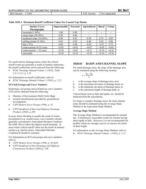
Table 1020.A Maximum Run<strong>of</strong>f Coefficient Values For Coastal Type Basins<br />
Surface Cover Impermeable Forested Agricultural Rural Urban<br />
Physiography<br />
mountain (>30%) 1.00 0.90 - - -<br />
steep slope (20-30%) 0.95 0.80 - - -<br />
moderate slope (10-20%) 0.90 0.65 0.50 0.75 0.85<br />
rolling terrain (5-10%) 0.85 0.50 0.40 0.65 0.80<br />
flat ( 25 years +0.10 +0.05 +0.15 +0.10 +0.10<br />
snowmelt +0.10 +0.10 +0.10 +0.10 +0.10<br />
For small interior drainage basins where the critical<br />
run<strong>of</strong>f events are generally a result <strong>of</strong> summer rainstorms,<br />
the run<strong>of</strong>f coefficients can be selected from the following:<br />
• RTAC Drainage Manual Volume 1 (1982), Table<br />
2.4.1-2.4.3, p. 2.22.<br />
For information on run<strong>of</strong>f coefficients, refer to:<br />
♦ RTAC Drainage Manual Volume 1 (1982), p. 2.22.<br />
SCS Soil Groups and Curve Numbers<br />
Hydrologic soil groups and soil/land use curve numbers<br />
(CN) can be obtained from the following:<br />
• <strong>Ministry</strong> <strong>of</strong> Environmnet (MoE) Soils Maps<br />
• textural classifications provided by geotechnical<br />
investigations<br />
• CSPI Modern Sewer Design (1996), p. 67<br />
• CSPI Handbook <strong>of</strong> Steel and Highway Drainage<br />
Products (2002), p.109.<br />
In areas where flooding is usually the result <strong>of</strong> winter<br />
precipitation (e.g. coastal areas), curve numbers should<br />
generally correspond to Antecedent Moisture Condition<br />
III (AMC III) to reflect the highest run<strong>of</strong>f potential. In<br />
areas where critical run<strong>of</strong>f values are the result <strong>of</strong> summer<br />
storms (e.g. interior areas), Antecedent Moisture<br />
Condition II should be assumed.<br />
For information on SCS soil groups and curve numbers,<br />
refer to:<br />
♦<br />
♦<br />
CSPI Modern Sewer Design (1996), p. 68 &69.<br />
CSPI Handbook <strong>of</strong> Steel Drainage and Highway<br />
Construction Products (2002),p. 108.<br />
1020.03 BASIN AND CHANNEL SLOPE<br />
For small drainage areas, the slope <strong>of</strong> the drainage area<br />
can be estimated using the following formula:<br />
h1 − h2<br />
s =<br />
L<br />
s is the average slope <strong>of</strong> drainage area, m/m<br />
h 1 is the maximum elevation <strong>of</strong> drainage basin, m<br />
h 2 is the minimum elevation <strong>of</strong> drainage basin, m<br />
L is the maximum length <strong>of</strong> drainage path, m<br />
Vertical drops such as falls and rapids, etc. should be<br />
deducted from the calculations.<br />
For large or complex drainage areas, the main channel<br />
slope should be estimated using the Average Slope<br />
Method or the Equivalent Slope Method.<br />
Average Slope Method<br />
The Average Slope Method is recommended for normal<br />
use. It should give reasonable results for streams having<br />
short rapids or falls. However, it is not recommended for<br />
pr<strong>of</strong>iles which are strongly convex or concave for much<br />
<strong>of</strong> their length.<br />
For information on the Average Slope Method, refer to:<br />
♦ RTAC Drainage Manual Volume 1 (1982), p. 2.11.<br />
Page 1020-2 June, 2007