1000 Hydraulics Chapter - Ministry of Transportation
1000 Hydraulics Chapter - Ministry of Transportation
1000 Hydraulics Chapter - Ministry of Transportation

Create successful ePaper yourself
Turn your PDF publications into a flip-book with our unique Google optimized e-Paper software.
BC MoT<br />
SUPPLEMENT TO TAC GEOMETRIC DESIGN GUIDE<br />
MoT Section 1020 TAC Section 2.1.2<br />
Equivalent Slope Method<br />
The Equivalent Slope Method is recommended for<br />
streams which have intermediate steep sections totaling<br />
over 10 percent <strong>of</strong> the overall length.<br />
For information on the Equivalent Slope Method, refer to:<br />
♦ RTAC Drainage Manual Volume 1 (1982), p. 2.13.<br />
1020.04 TIME OF CONCENTRATION<br />
For most drainage basins (e.g. those not effected by<br />
retention or detention), the “time <strong>of</strong> concentration” is<br />
defined as the time required for the surface run<strong>of</strong>f from<br />
the most remote part <strong>of</strong> the drainage basin to reach the<br />
point <strong>of</strong> concentration being considered. For very small<br />
basins, the following minimum times <strong>of</strong> concentration are<br />
recommended:<br />
urban<br />
5 minutes<br />
residential<br />
10 minutes<br />
natural, undeveloped 15 minutes<br />
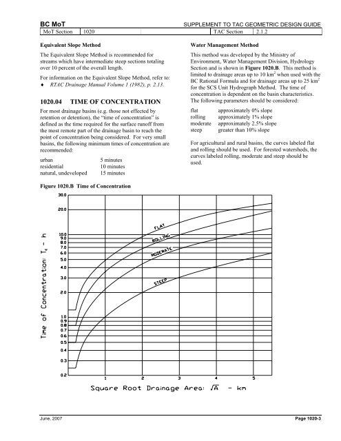
Water Management Method<br />
This method was developed by the <strong>Ministry</strong> <strong>of</strong><br />
Environment, Water Management Division, Hydrology<br />
Section and is shown in Figure 1020.B. This method is<br />
limited to drainage areas up to 10 km 2 when used with the<br />
BC Rational Formula and for drainage areas up to 25 km 2<br />
for the SCS Unit Hydrograph Method. The time <strong>of</strong><br />
concentration is dependent on the basin characteristics.<br />
The following parameters should be considered:<br />
flat approximately 0% slope<br />
rolling approximately 1% slope<br />
moderate approximately 2.5% slope<br />
steep greater than 10% slope<br />
For agricultural and rural basins, the curves labeled flat<br />
and rolling should be used. For forested watersheds, the<br />
curves labeled rolling, moderate and steep should be<br />
used.<br />
Figure 1020.B Time <strong>of</strong> Concentration<br />
June, 2007 Page 1020-3