1000 Hydraulics Chapter - Ministry of Transportation
1000 Hydraulics Chapter - Ministry of Transportation
1000 Hydraulics Chapter - Ministry of Transportation
You also want an ePaper? Increase the reach of your titles
YUMPU automatically turns print PDFs into web optimized ePapers that Google loves.
SUPPLEMENT TO TAC GEOMETRIC DESIGN GUIDE<br />
MoT Section 1020 TAC Section Not Applicable<br />
BC MoT<br />
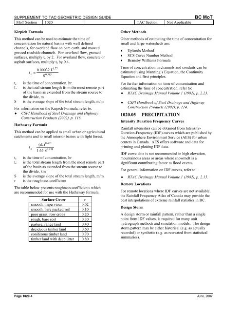
Kirpich Formula<br />
This method can be used to estimate the time <strong>of</strong><br />
concentration for natural basins with well defined<br />
channels, for overland flow on bare earth, and mowed<br />
grassed roadside channels. For overland flow, grassed<br />
surfaces, multiply t c by 2. For overland flow, concrete or<br />
asphalt surfaces, multiply t c by 0.4.<br />
0.77<br />
0.00032 L<br />
t<br />
c<br />
=<br />
0.385<br />
S<br />
t c is the time <strong>of</strong> concentration, hr<br />
L is the total stream length from the most remote part<br />
<strong>of</strong> the basin as extended from the stream source to<br />
the divide, m<br />
S is the average slope <strong>of</strong> the total stream length, m/m<br />
For information on the Kirpich Formula, refer to:<br />
♦ CSPI Handbook <strong>of</strong> Steel Drainage and Highway<br />
Construction Products (2002), p. 116.<br />
Hathaway Formula<br />
This method can be applied to small urban or agricultural<br />
catchments and to small interior basins with light forest.<br />
0.467<br />
(rL)<br />
t<br />
c<br />
=<br />
0.234<br />
1.65 S<br />
t c is the time <strong>of</strong> concentration, hr<br />
L is the total stream length from the most remote part<br />
<strong>of</strong> the basin as extended from the stream source to<br />
the divide, km<br />
S is the average slope <strong>of</strong> the total stream length, m/m<br />
r is the roughness coefficient<br />
The table below presents roughness coefficients which<br />
are recommended for use with the Hathaway formula.<br />
Surface Cover r<br />
smooth, impervious 0.02<br />
smooth, bare packed soil 0.10<br />
poor grass, row crops 0.20<br />
rough, bare soil 0.30<br />
pasture, range land 0.40<br />
deciduous timber land 0.60<br />
coniferous timber land 0.70<br />
timber land with deep litter 0.80<br />
Other Methods<br />
Other methods <strong>of</strong> estimating the time <strong>of</strong> concentration for<br />
small and large watersheds are:<br />
• Uplands Method<br />
• SCS Curve Number Method<br />
• Bransby Williams Formula<br />
Time <strong>of</strong> concentration in channels and conduits can be<br />
estimated using Manning’s Equation, the Continuity<br />
Equation and first principles.<br />
For further information on time <strong>of</strong> concentration and<br />
estimating the time <strong>of</strong> concentration, refer to:<br />
♦ RTAC Drainage Manual Volume 1 (1982), p. 2.23.<br />
♦<br />
CSPI Handbook <strong>of</strong> Steel Drainage and Highway<br />
Construction Products (2002), p. 114.<br />
1020.05 PRECIPITATION<br />
Intensity Duration Frequency Curves<br />
Rainfall intensities can be obtained from Intensity-<br />
Duration-Frequency (IDF) curves which are published by<br />
the Atmosphere Environment Service (AES) for urban<br />
centers in Canada. AES <strong>of</strong>fers s<strong>of</strong>tware and data for<br />
printing and plotting IDF data.<br />
IDF curve data is not recommended in high elevation,<br />
mountainous areas or areas where snowmelt is a<br />
significant contributing factor to flood events.<br />
For general information on IDF curves, refer to:<br />
♦ RTAC Drainage Manual Volume 1 (1982), p. 2.15.<br />
Remote Locations<br />
For remote locations where IDF curves are not available,<br />
the Rainfall Frequency Atlas <strong>of</strong> Canada may provide the<br />
best interpolations <strong>of</strong> extreme rainfall statistics in BC.<br />
Design Storm<br />
A design storm or rainfall pattern, rather than a single<br />
point from IDF values, is required for many unit<br />
hydrograph methods and simulation models. The design<br />
storm pattern may be either historical (e.g. as actually<br />
recorded) or synthetic (e.g. as recreated from statistical<br />
summaries).<br />
Page 1020-4 June, 2007


