

le-,3f - E-Library - WMO
le-,3f - E-Library - WMO
le-,3f - E-Library - WMO

You also want an ePaper? Increase the reach of your titles
YUMPU automatically turns print PDFs into web optimized ePapers that Google loves.
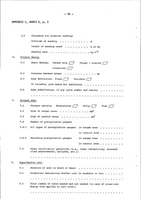
- 90 -APPENDIX C, ANNEX B, p. 23.3 Procedure for airborne seeding:Altitude of seedingLength of seeding trackSeeding rate4. Project design. . . . . . . . . .mm or km4.1 Basic design: Target only / /Target + control /--;4.24.3Cross-over / /Distance between areas:Area definition: Fixed /--; Variab<strong>le</strong> / /If variab<strong>le</strong>, give basis for definition• km4.4 Area subdivisions, if any (give number and 'nature)5. Project site5.1 Project terrain: Mountainous /--; Hilly / . / Flat / /5.25.3Size of targetarea:Size of control area:•••• km 2• • • • • • km 25.4 Number of precipitation gauges:5.4.15.4.2AlI types of precipitation gauges:Recording precipitation gauges:in target areain control areain target areain control area5.5 Other verification quantities (e.g., radar ref<strong>le</strong>ctivity, aircraftcloud measurements, hailpads, etc.),. . . . . . . . . . . . . . . . . . . . . . . . . . . . . .6. Experimental unit6.16.2Duration of unit in hours or days:Conditions determining whether unit is seedab<strong>le</strong> or not,6.3 Total number of units seeded and not seeded (in case of cross-overdesign this applies to each area):. . . . . . . . . . . . . . . . . . . . . . . . . . . . . . . . . . .


